Connected Regional Transportation Service: Northern Virginia Regional Mobility Initiative
b) Project Narrative
i. Project Description
1. Introduction
The Connected Regional Transportation Service – Northern Virginia Regional Mobility Initiative will provide Northern Virginia with more reliable travel times for commuters and more travel choices between modes. We will do this by implementing one of the nation's first unified, regional, predictive, transportation services for all agencies to make transportation management decisions collectively and to make transportation more reliable and seamless for users. We will install supporting technologies for this service. We will provide end-to-end connected intermodal transportation service data in one place for private sector/media to distribute to consumers. This will improve mobility, particularly when major incidents occur. Consider this story:
On the same day, Ned, a traffic operator is starting his shift at the Public Safety and Transportation Operations Center Project in Fairfax. He receives a radio broadcast from the Safety Service Patrol that a tractor-trailer has overturned on I-66 Eastbound near the I-495 Interchange; only one lane of traffic remains passable. Ned enters the incident information in VDOT's Advanced Traffic Management System and the information is automatically populated in the Data Warehouse for exchange with VDOT's partners, including local transportation and transit agencies. The DSS system pops-up on Ned's monitor and the simulation tool has already calculated the impact of the incident on travel time in the network and created a response plan for implementation, including points-of-contact, traffic signal plan information, transit schedules and passenger loading, etc. The plan is simultaneously viewed by the operators overseeing conditions on arterials (e.g., US-50 and SR-123) and transit agencies. Ned reviews the plan and, after confirmation from the arterial and transit agencies, clicks "Execute." The agencies coordinate to ensure that the pre-agreed signals plans are in place and to augment train service on Metro Rail.
In the meantime, Lisa and her co-passengers are on their way to Arlington on I-66 just east of Centreville, when a traffic alert, transmitted through the 5G connected vehicles communications infrastructure on the roadway, pops-up on her in-vehicle display. She touches a button on her steering wheel and a text-to-speech system reads the message: "OVERTURNED TRACTOR-TRAILER ON I-66 EB AT I-495 EXIT. ONE LANE OPEN."
The in-vehicle display shows her travel time has increased to 115 minutes on her regular route along I-66. She will not have enough time to prepare and set up for her presentation! The system calculates the fastest route and mode alternatives based on current transportation conditions. Several options are available to Lisa: exit I-66 at US-50 and drive to Arlington (estimated travel time of 72 minutes) or park at the Vienna Metro and take the train (travel time of 58 minutes). Unfortunately, there are only 14 spaces available at the Metro parking lot. Lisa chooses the US-50 option. Using connected vehicle technology, the signal countdown timer for the approaching signals on US-50 is shown on her vehicle display to help her maintain a steady speed and reduce delay at intersections. Lisa arrives at her office with time to spare before her meeting.
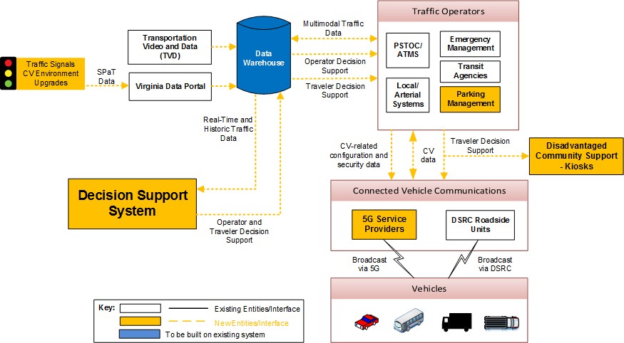 Figure 1: Concept Diagram
The Connected Regional Transportation Service: Northern Virginia Regional Mobility Initiative (NOVA RMI) will enhance the safety and mobility of travel in the region through the application of advanced technologies and operational strategies. The RMI will build on integrated corridor management activities (ICM) already underway in NOVA. It will pull together a range of NOVA projects, including the I-66 Express Lanes project, and serve as the "glue" for linking together the various components.
The NOVA RMI will establish a coordinated regional relationship across two of the most congested corridors in the nation: I-95/I-395 and the East-West Travel Shed (anchored by I-66 and the Dulles Toll Road). Key components of the initiative will include (1) a regional ICM Decision Support System (DSS), (2) a regional Data Warehouse and Portal, (3) a plan for aligning technologies and closing gaps across the region and (4) providing support for disadvantaged communities. Figure 1 shows the concept diagram.
2. Entities Entering the Agreement
The Connected Regional Transportation Service - NOVA RMI development, implementation, and operation will be directly managed by the Virginia Department of Transportation (VDOT) in partnership with the Virginia Department of Rail and Public Transportation (DRPT) and the Northern Virginia Transportation Authority (NVTA). VDOT will function as the administrative and technical manager for the project. DRPT will serve as the liaison/advocate to the region's transit community, including oversight of transit activities. NVTA will oversee regional planning, funding, and implementation activities in relation to the ICM program, and serve as a liaison/advocate to localities.
2.1. Partners
2.1.1. Virginia Department of Transportation
VDOT is responsible for building, maintaining, and operating the roads, bridges and tunnels in the Commonwealth of Virginia. It is overseen by the Commonwealth Transportation Board, which has the authority to fund airports, seaports, rail, and public transportation. The Northern Virginia Region where the NOVA RMI will be deployed includes more than 17,000 lane miles of roads in the counties of Fairfax, Arlington, Loudoun, and Prince William. Secondary roads in Arlington are maintained by the county. The corresponding VDOT District supports highways in nine cities and towns.
Developing, deploying, and successfully operating advanced transportation solutions that enhance safety and mobility is not new to the VDOT Northern Virginia Region. In recent years VDOT has overseen the deployment of high occupancy/toll (HOT) lanes on a 14-mile segment of I-495, extending from the Springfield Interchange to north of the Dulles Toll Road. The Northern Virginia Region was also responsible for delivering the first implementation of a fully integrated Active Traffic Management (ATM) solution on the East Coast.
2.1.2. Virginia Department of Rail and Public Transportation
DRPT reports to the Secretary of Transportation. Its primary focus is to facilitate the movement of people and goods throughout the Commonwealth; its principal areas of activity are rail, public transportation, and commuter services. DRPT works with local, regional, state, and federal governments, as well as private entities to support for projects and programs by (1) assessing feasibility and environmental impacts of new and expanding services; (2) conducting statewide rail and public transportation studies; (3) planning and programming new services and capital improvement projects; and (4) providing leadership, advocacy, technical assistance, and funding.
2.1.3. Northern Virginia Transportation Authority
NVTA is responsible for long-range transportation project planning, prioritization, and funding for regional transportation projects in Northern Virginia. NVTA's policies and priorities are guided by two overarching goals: (1) reduce congestion, and (2) move the greatest number of people in the most cost-effective manner. These two goals are combined with performance-based criteria, such as the ability to improve travel times, reduce delay, connect regional activity centers, and improve safety and air quality. NVTA works toward regional consensus when setting regional transportation policies and priorities for transportation projects. NVTA is also charged with developing and updating the long-range regional transportation plan for Northern Virginia, currently TransAction 2040.1 NVTA's regional partners are:
- VDOT
- Arlington County
- Fairfax County
- Loudoun County
- Prince William County
- City of Alexandria
- City of Fairfax
- City of Falls Church
- City of Manassas
- City of Manassas Park
- Town of Dumfries
- Town of Herndon
- Town of Leesburg
- Town of Purcellville
- Town of Vienna
- WMATA
- NVTC
- Potomac and Rappahannock Transportation Commission
- DRPT
- Virginia Railway Express
2.2. Management Approach
VDOT will be responsible for the overall management of the NOVA RMI. It will employ standard project management techniques based on the Project Management Body of Knowledge (PMBOK) to effectively manage the range of activities and stakeholders required under this on-call services contract.2 To facilitate the comprehensive and proactive management of project services, VDOT will follow typical project management best practices and develop an overall Project Management Plan (PMP) to guide the delivery of the project. The PMP will be composed of multiple components that detail the execution, management, control, collaboration, and coordination of the various tasks, and will be updated routinely. These components will include the following, as appropriate: (1) Work Plan, (2) Systems Engineering Management Plan, (3) Work Breakdown Structure, (4) Scope Management Plan, (5) Schedule Management Plan, (6) Cost Management Plan, (7) Risk Management Plan, (8) Resource Management Plan, (9) Communications Management Plan, and (10) Quality Management Plan.
The partners to this program – VDOT, DRPT, and NVTA – have already signed a Partner Management Agreement. Agencies and stakeholders participating in the regional ICM program will execute a memorandum of understanding (MOU).
Multiple contract vehicles are available to VDOT for performing and completing the program work expeditiously, consistent with the Deployment Schedule in Section 12. Most of the work will be performed under VDOT's Design and ITS On-Call contracts, all of which were recently renewed for multi-year terms. The On-Call contracts are all "Federally-eligible." Multiple VDOT On-Call contractors have been involved in our ICM planning activities, and several have national experience planning and implementing ICM, including DSS deployment.
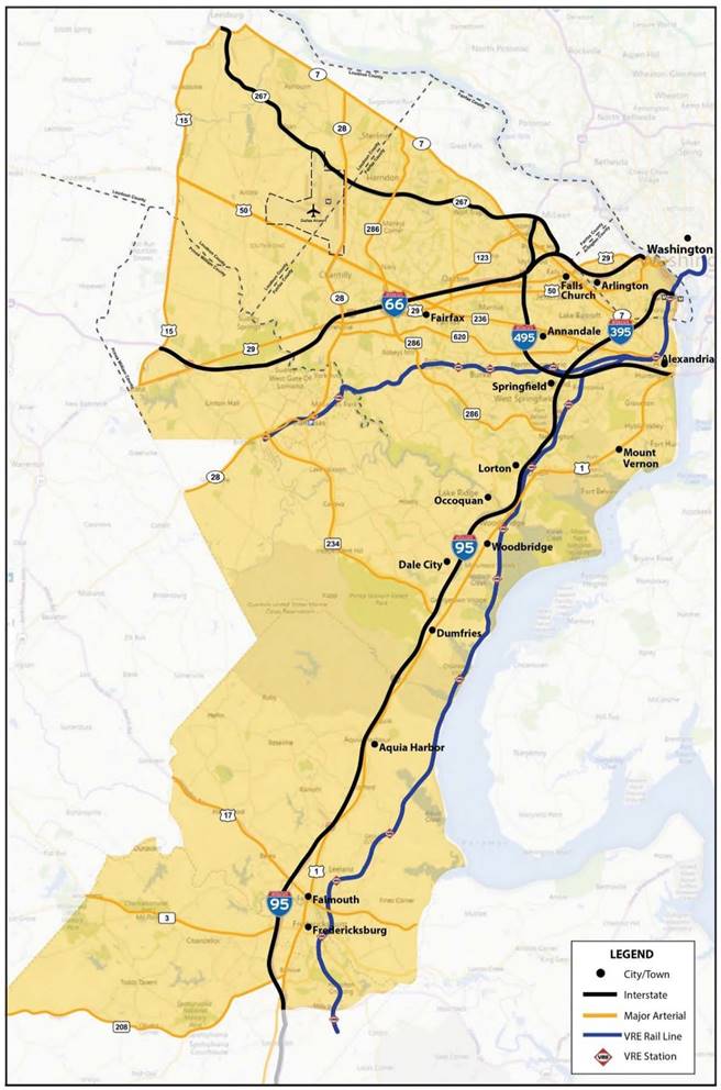
Figure 2: NOVA Regional Mobility Initiative Deployment Area
3. Geographic Area
The Connected Regional Transportation Service – Northern Virginia Regional Mobility Initiative will be deployed in Northern Virginia, which is comprised of multiple counties and cities to the south and west of Washington, D.C. The deployment area is shown in Figure 2. NOVA's population is approximately 2.8M residents, making it the most populous region in Virginia and the Washington metropolitan area.
Northern Virginia is often characterized as the "economic engine" for the Commonwealth of Virginia. It accounts for a significantly larger job base than either Washington, D.C. or the Maryland suburbs. In addition to business being driven by proximity to the federal government, Northern Virginia is known for its entrepreneurial spirit and technology-based companies.
As a result of the robust economy in Northern Virginia, several patterns have emerged that foster increased traffic congestion. Over the last three decades, NOVA has diversified from a "residentially based" economy into one that is technology-intensive and knowledge-based. The economy has also evolved from one primarily based on the Federal government, to one that is more driven by income growth and private-sector expansion. Consequently, Northern Virginia has become an importer of workers commuting from D.C., suburban Maryland, and points further outside the Washington metropolitan area. These factors, coupled with dispersion of major employment centers across the region (Tysons Corner, Reston, the Pentagon, Crystal City, Fort Belvoir, etc.) have contributed to significant growth in traffic congestion.
Northern Virginia is served by a range of multi-modal transportation services which will be leveraged as part of the proposed NOVA RMI. The highways and major arterials that are part of the RMI include: (1) major interstate limited-access facilities (I-66, I-95, I-395, and I-495), including HOT lanes; (2) tolled non-interstate limited-access facilities (SR-267, Dulles Toll Road and Dulles Greenway); and (3) principal arterials (SR-28, SR-286, SR-7, US-50, US-29, and US-1).
I-95, I-66 and the Dulles Toll Road are important multi-modal corridors serving Northern Virginia, and a range of transit options critical to the success of the ICM and are available for long- and short-distance commuters, including the following:
- Multiple rail transit options, including Metrorail's Orange, Silver, and Blue Lines, which are considered heavy rail, and the Virginia Railway Express (VRE), a commuter rail service which runs near I-66 between Manassas and Washington, D.C. and I-95 between Fredericksburg and Washington, D.C.
- Multiple express bus services, including commuter bus services provided by Metro Bus, Loudoun County Transit, the Potomac and Rappahannock Transportation Commission (PRTC), and Fairfax Connector.
- Major park-and-ride lots, including lots with Metro Rail stations, VRE stations, termini for commuter bus services, and VDOT commuter lots.
- High-occupancy vehicle (HOV) lanes and facilities, including I-66 inside the Beltway during weekday peak periods in the peak direction (eastbound during the AM peak and westbound during the PM peak); peak-period HOV lanes are also provided in the left-most lane along I-66 west of I-495 and along SR 267 between I-495 and SR 28.
- HOT lanes along I-495, between the I-95 interchange and Tysons Corner, and on I-95/I-395, from Stafford County northward. These lanes are free for vehicles with three or more people and offer variable tolls for other users. Additional facilities in the region, including notably I-66, will be reconstructed to include HOT lanes in the near future.
- Various options for carpooling, vanpooling, and ride-sharing, including many recent on-demand services accessible via a mobile app.
- Options for tele-working and co-working.
- Amtrak, which operates several stations within the corridor and provides passenger rail service along Amtrak's Northeast Regional, Crescent, Silver Service/Palmetto, Carolinian/Piedmont and Cardinal routes, running from Washington, D.C. to the south and west.
4. Real-World Issues and Challenges
4.1.1. Northern Virginia Mobility Challenges and Opportunities
Transportation congestion in the Northern Virginia region is among the worst in the nation. According to the 2015 Urban Mobility Scorecard, automobile commuters in the region incurred an average of 82 hours of delay per commuter and wasted 25 gallons of fuel, equating to a cost of $1,834 per commuter.3 These experiences are reflected in the operational conditions on I-95 and I-66, the two primary corridors of focus under the Northern Virginia Regional Mobility Initiative. In 2016, travelers on the I-66 corridor endured over 4.2M hours of congestion-related delay, at an annualized cost of $160M. Likewise, travelers on the I-95 corridor encountered 4.6M hours of congestion-related delay, at an annualized cost of $173M. Average commute times in Northern Virginia are among the longest in the U.S., averaging in excess of 30 minutes. Indeed, the travel time index across the region often exceeds 2.5, meaning that trips that should take 30 minutes under free-flow conditions require 75 minutes to complete.
Virginia is engaging in a host of regional strategies to mitigate congestion. These include the introduction of managed lanes across the region (including the pending deployment of HOT lanes on I-66, both inside and outside the Capital Beltway), new service on Metro Rail's Silver Line, and a host of technology projects, such as the Virginia Connected Corridors initiative, which is facilitating the real-world deployment of connected-vehicle technology.
Virginia views integrated corridor management (ICM) as an important tool in the arsenal for combating congestion and promoting safety. In the current climate, where a plethora of regional initiatives are underway or about to get started, ICM strategies are more pertinent than ever – as the "glue" to link the disparate transportation initiatives together. To date, VDOT has conducted two ICM planning efforts in Northern Virginia and is ready to implement those plans.
ICM Planning in Northern Virginia. For the I-95/I-395 corridor, VDOT completed a concept of operations and implementation plan in 2012 and 2013, respectively. Likewise, in the East-West Travel Shed, VDOT has prepared an ICM concept of operations and is finalizing its implementation plan. The latter work is being performed under a 2015 FHWA ICM Deployment Grant. VDOT is committed to implementing ICM in Northern Virginia. It is also interested in applying the lessons learned to corridors in other parts of the Commonwealth.
VDOT's approach to ICM has emphasized multi-modalism. It has also focused on extensive engagement by VDOT's partners and stakeholders across the region. For instance, in the East-West Travel Shed project, regional stakeholders participated in four major Stakeholder Coordinating Committee meetings. Additionally, a total of 20 stakeholder workshops, called Resource Forums, were convened to plan for the ICM program. These workshops sequentially focused on (1) identifying pertinent study area needs, (2) brainstorming ICM-related strategies to address those needs, and (3) specifying plans for implementing the ICM strategies. A management committee, called the Program Advisory Group, has been in place throughout the planning process, to oversee the ICM efforts. The stakeholder groups are shown in Figure 3.
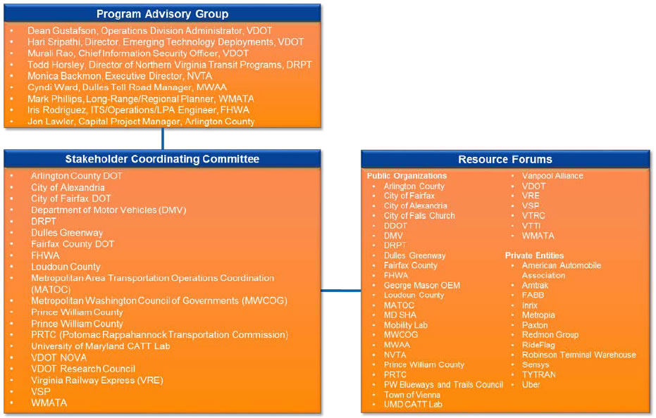
Figure 3: NOVA East-West ICM Stakeholder Groups
Challenges and Needs. Through a dual process of data-driven analysis of corridor conditions and stakeholder deliberations, a host of pertinent corridor-level challenges were identified. These challenges were distilled down to a small number of top-level needs, as follows: (1) need expanded operational coordination and information-exchange across agencies, jurisdictions, and modes; (2) need accurate, reliable, real-time information on transit and commuter system status; (3) need expanded operational coordination and information-exchange across agencies, jurisdictions, and modes; (4) need on-demand, real-time, predictive user-centric traveler information encompassing end-to-end trips; and (5) need to promote and empower incentivized "smart" traveler choices.
A Framework Approach to ICM. To address corridor needs, three ICM program goals were identified: (1) optimize performance, (2) enhance reliability, and (3) support traveler choice.
To achieve these goals, five ICM foundational initiatives were defined:
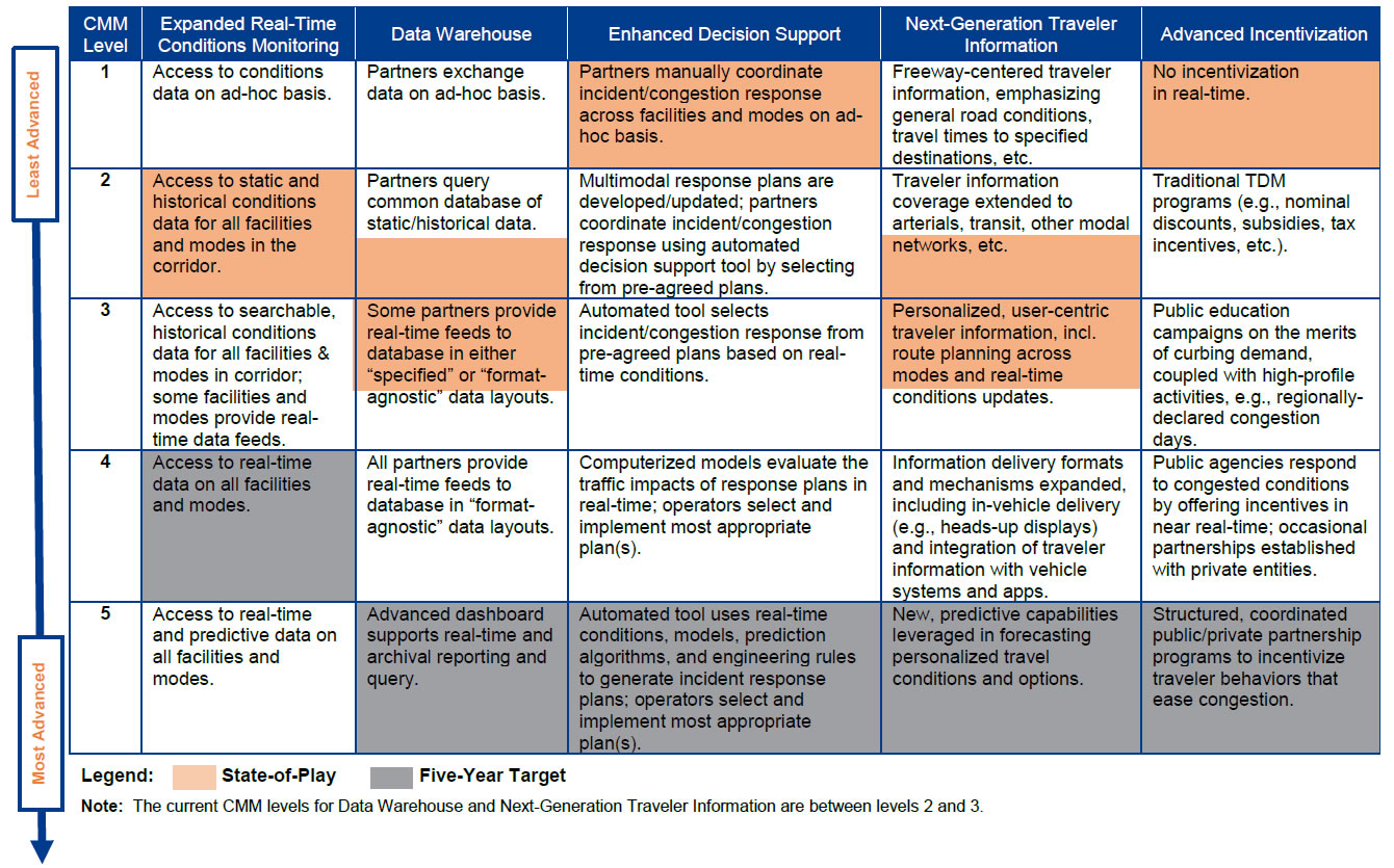
- Expanded Real-Time Conditions Monitoring. The objective is to constantly "know" conditions on freeways, arterials, transit, parking lots, etc. across the corridor.
- Data Warehouse. A common data repository for the sharing and exchange of information among the regional partners.
- Enhanced Decision Support. An automated operations tool that supports systematic, structured responses to recurring and non-recurring congestion.
- Next-Generation Traveler Information. On-demand, real-time and predictive, multi-modal trip guidance for travelers; the initiative will rely predominantly on private, third-party providers.
- Advanced Incentivization. Whereas the other initiatives focus on managing congestion, this one emphasizes managing demand; includes strategies to reduce the number of vehicles and travelers on the transportation grid during peak periods.
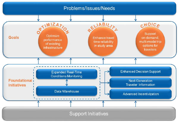
Figure 4: ICM Framework
In addition to these foundational initiatives, secondary support initiatives were identified in multiple key areas: (1) roadway operations, (2) incident and emergency management, (3) bicycles and pedestrians, (4) freight, and (5) connected vehicle technology.
Five-Year Vision. Planning principles from the Capabilities Maturity Model (CMM) were applied to the ICM framework, as shown in Table 1. Each foundational initiative is envisioned as progressing along a continuum of five levels of increasing "maturity," from "least advanced" to "most advanced." The table further demarcates (1) current state-of-play for each initiative, and (2) each initiative's targeted capability over the five-year planning horizon. The ICM deployment "projects" that have been identified and defined are collectively intended to move the initiatives from state-of-play to targeted capability.
The overarching five-year vision for the ICM program is as follows:
The aim of [the] ICM program is to bring structure, stability, and balance to multi-modal transportation across the East-West Travel Shed. The vision is one of continuous situational awareness on conditions in the corridor, so that operations teams can respond quickly and appropriately to changing circumstances. The aim is an integrated corridor in which travelers have steady, easy access to a suite of real-time transportation options, enabling them to arrive at informed traveler choices. Travel-time reliability will be significantly improved, so that the time needed to complete individual trips can be more effectively judged. Travelers will be exposed to incentives and strategies to curb peak-period transportation demand.4
Commitment to Deploy. VDOT, its partners, and stakeholders are committed to implementing the ICM program delineated in the concept of operations document. To move the program forward, USDOT funding is requested in support of critical program elements.
Table 1: Capabilities Maturity Model (CMM) View of the Five Foundational Initiatives
5. Transportation Systems and Services
The ATCMTD concept proposed herein will combine two geographic areas – the East-West Travel Shed (anchored by I-66) and the North-South Corridor (anchored by I-95/I-395). Both areas have been the subject of extensive ICM planning studies by VDOT. Additionally, there is a strong synergistic relationship between the two areas – transportation conditions in one area typically impact circumstances in the other. Managing the two areas as a single ICM region seems both sensible and appropriate, and offers the opportunity to demonstrate and deploy ICM at the regional level. The ICM framework developed for the East-West Corridor, including the five foundational initiatives, is also applicable to the North-South Corridor. Hence, the ICM framework concepts will be applied across the entire region.
The NOVA RMI plan is consistent with the Northern Virginia Regional ITS Architecture, updated in 2011. The foundational initiatives and some of the related information flows will result in updates to the regional architecture. The recommended updates to the architecture will be submitted through the VDOT Systems Engineering and Architecture Compliance (Rule 940) Checklist process.
The NOVA RMI has identified several primary elements for which ATCMTD funding is sought. The requested funding, if made available, will enable VDOT and its project partners to complete important milestone activities under all five ICM foundational initiatives.
The specific activities for which funding is sought are as follows:
- Regional ICM Decision Support System. Here we will implement a sophisticated automated tool that generates incident and congestion management response plans based on real-time conditions. (Completes activities under the Enhanced Decision Support initiative.)
- Regional Data Warehouse. This set of projects will build on existing statewide and regional systems to establish a warehouse for the real-time exchange of information among stakeholders. The warehouse will link to Virginia's emerging Statewide Data Portal, which will deliver pertinent transportation data to third-party providers and the general public. (Completes most activities under the Data Warehouse initiative.)
- Technology Alignment and Gap Closures. These technology installations are intended to provide consistent, multimodal traffic monitoring and management support across the region. They include signal system enhancements, parking lot monitoring, and communications deployments – all designed to advance the region's connected vehicle technology readiness. Key arterials across the region will be targeted. (Completes selected activities under the Expanded Real-Time Conditions Monitoring initiative.)
- Additional Activities. These efforts include (1) first-mile/last-mile traveler services targeted at disadvantaged populations in the US-1 corridor, and (2) public-private partnership outreach to traveler information and advanced communications providers to dialogue with them on how their services can most effectively address the NOVA RMI's program requirements. (Completes selected activities under the Next-Generation Traveler Information and Advanced Incentivization initiatives.)
The activities for which funding is sought are further enumerated below.
5.1. Decision Support System (DSS)
A Decision Support System (DSS) is the foundational technology behind the deployment of a regional integrated corridor management system. It is the basis of the information-fed, objectives-driven, software-intensive system. Individual agencies operating in the region already perform regular traffic operations and incident/event response operations; however, coordinated responses among agencies happen either ad-hoc or manually. A DSS with multi-agency data fusion and common data-dissemination provides the foundation for coordinated, automated, regional-wide responses to unusual transportation situations.
For this project, a next-generation DSS for traffic management centers is envisioned as a stand-alone application as shown in the architecture in Figure 5. The DSS will connect to the Data Warehouse and receive real-time and historical data. The outputs of the DSS, which includes the actions from the selected response plan, will be provided to the "Next-Generation Traveler Information System" and the "Operator Management System." To increase both collaboration and technology-independence, the stand-alone DSS will utilize standardized data-exchange interfaces, such as the Traffic Management Data Dictionary.
The next-generation DSS will include a complex grouping of integrated subsystems. These include an off-line simulation engine, an on-line (i.e., real-time) simulation engine, an expert rules engine, and an evaluation engine. The next-generation DSS will set the stage for "big data" analytics.
Before moving into development, a Development Plan will be created that documents how the DSS will meet the project requirements, including detailed specifications for the various components of the system. The delivered solution will have all the planned functionality consistent with the existing ICM Concept of Operations document.
The Development Plan will summarize the existing conditions of the corridor, covering the status of the traffic conditions, state-of-play, and capabilities of the system devices and the current operational process used by the different agencies within NOVA who manage the transportation network. VDOT will organize additional stakeholder meetings to provide and review these items. Through these meetings, an inventory of the existing Incident and Event Management Plans that are currently implemented within the corridor by each agency will be prepared. The inventory will be reviewed for consistency with the Concept of Operations – Operational Scenarios section. VDOT will summarize how each entity reacts under normal and incident management conditions in relation to freeway, arterial, and transit activities. Where possible, the actions will be merged into the five principal incident management strategies:
- No Incident/No Event (Normal Conditions)
- Transit Incident
- Scheduled Event
- Roadway Incident
- Others (Maintenance, Weather, and Technology)
A signal-readiness inventory will be performed to ensure that the signalized intersections can be leveraged as part of the scenarios; timing plans will be reviewed and gaps regarding how that signal controller can support ICM operations will be identified. An inventory of controllers needing additional timing plans and having the space available for the additional plans will be generated. VDOT will hold a review meeting with its stakeholders to discuss the inventory prior to developing new traffic signal timing plans. The existing conditions will be summarized in an Existing Conditions Report as part of the DSS Development Plan.
In parallel to the existing conditions review, the DSS development plan will be based on the following evaluation elements:
- Use of business rules and analytics for initial evaluations of response plans built from stored pre-agreed response plans for each agency.
- Use of an On-Line Simulation engine that will provide continual network predictions, as well as simulated evaluation of response plans to insure the best plan is deployed.
- Use of an off-line modeling tool to build new response plans which will be added to the library of pre-agreed responses.
These deployment stages will be applied to the four key elements of the DSS:
- Expert Rules Engine (ERE) – Monitors current travel conditions and compares current with predicted conditions, in order to build incident response plans and monitor the progression of an implemented response plan.
- Off-Line Simulation Modeling Tool – Furnishes verification and evaluation support prior to implementation of infrastructure changes, ITS changes, response plans reconfiguration, demand changes, or other traffic engineering-related studies.
- On-Line Simulation Predictive Tool – Uses near real-time network predicted conditions and response plan evaluation simulations to provide the metrics used by the evaluation engine recommending the optimal response plan.
- Evaluation Engine – Determines the optimal response plan to be implemented using stakeholder-defined Key Performance Indices (KPIs), i.e., Improved Travel Time Reliability, Improved Traffic Throughput, Reductions in Person-Hours of Delay and Vehicle-Hours of Delay, Reduction in Emissions, Shorter Traveler Journey Time, Improved Traveler Decision-Making, and Reductions in Multi-Modal Delay.
At the start of operations, the evaluation engine will use rules, analytics, and current conditions for scoring the response plan against the "Do-Nothing" scenario. After gathering the initial real-time data, the evaluation engine will generate the various KPIs by comparing the modeled results of each Response Plan against the "Do-Nothing" scenario. Once a response plan is selected to have a significant enough benefit when compared to the "Do-Nothing" scenario, the response plan elements will be disseminated to the individual agencies as warranted by device ownership. Response plans include dissemination of information via the Connected Vehicle subsystem.
The initial architecture of the Enhanced DSS is shown in Figure 5 depicting the high-level flows.
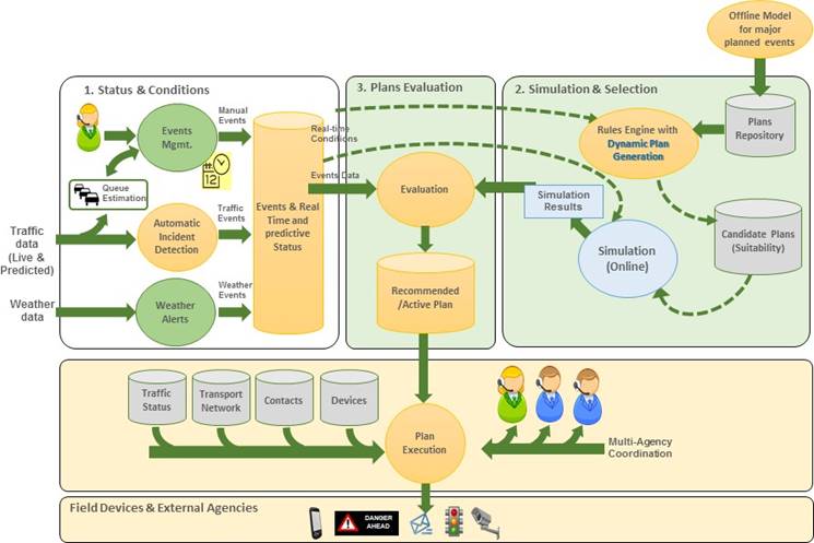
Figure 5: DSS Architecture
5.2. Regional Data Warehouse and Portal
The Regional Data Warehouse will be a vast repository of regional travel conditions data from a host of sources. It will include both real-time and archived data on roadway operations, signals, transit, parking, bikes and pedestrians, freight, incidents, as well as probe and CV-generated data.
Several options are available as candidate "platforms" for the Data Warehouse. One key option is to build on the established Regional Integrated Transportation Information System (RITIS). RITIS is an existing transportation repository in the Washington, D.C. area that supports real-time information-exchange between Virginia, Maryland, and the District of Columbia. While changes and additions to RITIS will be required to customize it to the NOVA RMI requirements, the system already supports many of the functions and capabilities required by the Data Warehouse, including real-time data-processing, situational awareness tools, and archived analytics. RITIS already contains much of the data and functionality necessary to support the regional ICM program including real-time transit AVL and schedules, bike-share, probe, sensor, weather, ATMS, county/city CCTV, and more.
The Warehouse will interface with complementary statewide data repositories such as iPeMS, the VDOT Transportation Video and Data (TVD), and a Virginia Data Portal. iPEMS is a performance measurement and analysis tool. TVD captures and provides relevant information including CCTV video from the VDOT's VA Traffic and transportation operations centers (TOC) to Virginia 511 traveler information system and external partners. The Virginia Data Portal is cloud-based system, being launched in Summer 2017, to support the dissemination of transportation data, including connected and automated vehicle applications, for use among third-party application developers and the general public.
The Warehouse will contain both real-time and archived data. As shown in the ICM Framework diagram in Figure 4, the Warehouse will support other foundational initiatives, including conditions monitoring, decision support, and traveler information. It will serve as the common platform for the sharing and exchange of information among the regional partners; it will include a graphical user interface (GUI) with querying, visualization, and analytic capabilities. In addition to facilitating real-time information-exchange, the Warehouse will furnish the data required by the Enhanced DSS and the Connected Vehicle technology subsystem, exchange data with third parties through the Virginia Data Portal, and generate pertinent performance metrics on an on-going basis.
Agencies often have difficulty providing or converting their data to prescribed formats. This is a critical issue and will likely impact the ability of some stakeholders – notably transit agencies – to be contributing partners to the NOVA RMI. To address this issue, the Data Warehouse will be designed to accept data in broad-ranging formats (i.e., "format agnostic"). In general, the Warehouse will be able to capture data entered into agencies' local systems, such that operators will not be required to reenter data into the Warehouse.
The VDOT Advanced Traffic Management System (ATMS) and Data Warehouse will be disparate entities. The Warehouse will ingest pertinent ATMS data elements directly from the ATMS, while others are captured through the TVD system. An institutional framework defining agency relationships to the Warehouse will be spelled out in a memorandum of understanding.
Implementation of the Warehouse will include performing the following key tasks:
- Identify and ingest additional missing data elements from stakeholders, including, but not limited to:
- Additional multi-modal data from Virginia (for example, VRE).
- SPaT/signal data from arterials (refer to Figure 6, CV Concept diagram).
- NOVA speed/volume sensor locations and configuration verification.
- Other data sources and systems, including the Virginia Data Portal.
- Stress test the system, and make improvements where necessary to support production-level ICM functionality.
- Enhance the ability of RITIS to support connected and autonomous vehicle datasets in real-time.
- Provide documentation and support for ad-hoc reporting, analytics, and other API functionality.
- Coordinate with the agencies' cybersecurity teams to verify relevant security protocols requirements. Cybersecurity is an important element of VDOT's technology program. Virginia Executive Orders 6 and 7 address cybersecurity concerns and NOVA already complies with these executive orders.
- Establish a load balanced backup site for the Data Warehouse.
5.3. Technology Alignment and Gap Closure
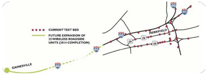
Figure 6: VDOT Testbeds (to be updated)
The ICM Concept of Operations noted that, while transportation technologies were present to enable an ICM program, they were not consistent across the region. For this reason, three technology alignment and gap closures are projects are proposed to enable the ICM program including Communications Resources for Connected Vehicle Applications, Traffic Signal Controllers for enhanced arterial operations, and Regional Parking Management Systems for mode shift opportunities.
5.3.1. Communication Resources for Connected Vehicles Project
VDOT has been a pioneer in the Connected Vehicle (CV) arena, as demonstrated by its leadership in the Connected Vehicle Pooled Fund Study (PFS) and participation in multiple NCHRP Project panels, the AASHTO CAV Technical Working Group (TWG) and the Vehicle-to-Infrastructure Deployment Coalition (V2I DC).
VDOT has actively deployed CV technologies through the Virginia Connected Corridor initiative whose goals include the development of CV applications, deployment of major CV testbeds and integration of CV technologies and solutions into VDOT's Transportation Operations Centers (TOC).
VDOT's testbeds include the Virginia Tech Transportation Institute's (VTTI) SmartRoad in Blacksburg, and two testbeds in NOVA covering both interstate and arterial routes (see Figure 6), inside the RMI area. VDOT has invested in the deployment of more than 60 CV technology-capable roadside units (RSUs), the development of CV applications, and supported the deployment of on-board units (OBUs) in private, commercial, and research vehicles.
Table 2 summarizes the CV applications and solutions that address VDOT's needs, as well as the performance metrics to ensure the needs have been met.
The NOVA RMI project will deploy CV technologies along the US-1 and RT-7 corridors, and expand existing deployments along US-50 and US-29. Additionally, the project will take advantage of recent announcements by both Verizon and T-Mobile to deploy 5G communications services along RT-1 in the Washington, D.C. area. While VDOT has extensive experience with RSU deployments and CV applications and is proposing to expand these deployments through CV-based Transit Signal Priority (TSP) along portions of US-50 and US-29, the utilization of emerging 5G services will expand CV coverage range, as well as bring the entire North American Connected Vehicle initiative to a new level. The 5G communications approach is not intended to replace the need for DSRC-based V2V and V2I Safety communications in the 5G-based coverage area. Rather, it demonstrates a complementary tool.
The project will also provide needed upgrades to approximately 120 traffic signal controllers in the corridor (see Section 5.3.2) to enable the provision of signal phasing & timing (SPaT) data, which will be made available to CV-equipped vehicles traversing the corridor.
This project will enable CV applications that provide the following features:
- CV-based transit signal priority (TSP) requests and confirmation to CV-equipped transit vehicles traveling the RT-1 corridor.
- CV-based signal phasing and timing information broadcasts to the CV-equipped vehicles.
- CV-based traveler information broadcasts to CV-equipped vehicles.
In general, the logical architecture of the CV subsystem will be part of the overall VDOT ICM Architecture and is depicted in Figure 7. The proposed architecture shows both DSRC-based and 5G-based communications services to support CV applications. However, VDOT is proposing to only deploy 5G-based services. The two approaches are shown here to indicate that both approaches fit within the overall ICM Architecture.
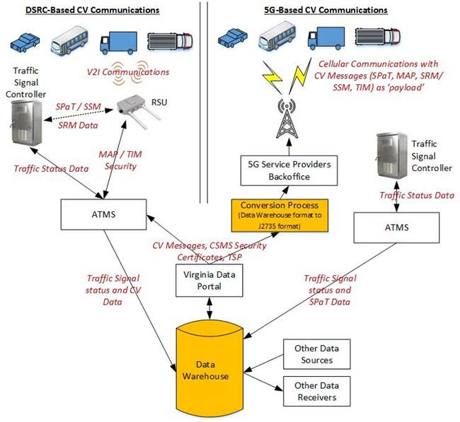
Figure 7: Connected Vehicle Subsystem Architecture
The purpose of proposing 5G communications services for this project is based on:
- The need for a real-life U.S. deployment of 5G communications technology and use in conjunction with CV applications to determine whether there are issues when 5G is rolled out nationwide.
- The announcement that cellular network provider, Verizon, will implement 5G technology in 13 major U.S. markets, including the Washington DC area.
- The announcement that cellular network provide, T-Mobile, has plans to provide 5G technology all across the U.S. by the end of 2018.
- The planning phase of this project is anticipated to end within early or mid-2019, depending on date of the ATCMTD grant awards, seamlessly aligning with the 5G roll-outs of both Verizon and T-Mobile.
- A potential opportunity for public agencies to reduce the field devices needing to be maintained, because 5G technology does not need specialized field devices (such as the RSUs needed for DSRC-based V2I communications).
Additionally, VDOT can leverage its Resource Sharing Program to advance the installation of 5G technologies with minimal direct costs. VDOT has actively leveraged this strategy for transportation technology communications via its fiber optic resource sharing opportunities since 1998. Over that time, VDOT has entered into 16 fiber optic resource sharing agreements with telecommunications providers to gain access to over 3,000 miles of fiber routes. Expansion of fiber resource sharing deployments in the NOVA RMI can provide backhaul capabilities for future 5G wireless towers. VDOT additionally manages a wireless resource-sharing program, where cellular and wireless providers establish service on structures installed on VDOT's limited access ROW for a monthly fee.
By providing such communication resources, the benefits of the existing and emerging connected vehicle program can be incorporated into the NOVA RMI by enabling data transfer to the Data Warehouse and the ICM Enhanced DSS.
5.3.2. Traffic Signal Controller Upgrades for Arterial Operations
VDOT recognizes that an effective NOVA RMI will require active management of parallel arterial systems. For this reason, VDOT's traffic signal system in NOVA was recently upgraded to include Advanced Transportation Controller (ATC) hardware and firmware. The new controllers deployed as part of this process allows for greater functionality of the approximately 1425 signals they currently operate in the region, and interoperability with regional partners.
Specifically, the new signal system provides:
- The ability to push SPaT (signal phasing & timing) data in real-time.
- An open-source platform (Linux-based) to accommodate future connected vehicle technology/applications coordinating with the signal controller.
- Implementation of Automated Traffic Signal Performance Metrics (ATSPM) that will allow greater efficiencies in optimizing traffic signal timings and coordination without the expense/effort of extensive traffic count data collection.
- Greater integration into a Central Signal System of monitoring/control features,
- Expanded capabilities and features for controlling multiple modes of transportation including, transit, pedestrian, bicycle, and freight without sacrificing the ability to efficiently manage passenger vehicle traffic.
- Improved functionality for providing emergency vehicle preemption/priority allowing for the immediate return of coordination to a corridor.
To enable the full functionality of the upgraded traffic signal system along US-1, US-29 and US-50, and SR-7, and support the functionality of additional Regional ICM components such as improved and expanded detection, monitoring, and communications systems, additional traffic signal enhancements are necessary. Traffic signal enhancements proposed as part of the NOVA RMI include:
- Integration with Locality Signals - Includes controller upgrades to ATC standards and related costs for cities and towns in the region, and integration of locality signal system controllers into the Central Signal System and ATMS platform.
- Enhanced Communications - Includes communications network upgrades within locality systems and linking to the VDOT system.
- Signal Upgrades/Detection for Performance - Includes providing upgraded presence and advance vehicle detection needed for expanding the Automated Traffic Signal Performance Measures (ATSPMs) functionality.
5.3.3. Regional Parking Management System
VDOT has sponsored a successful Park & Ride (P&R) Lot Program to aid I-95 corridor commuters. P&R lots allow commuters to park their vehicles and take alternative transportation modes such as cars/vanpools, buses, or trains. Commuters can pick-up passengers at any of the commuter lots and take advantage of the I-95/395 Express Lanes (HOV-3 lanes) for a faster and free-of-toll commute. Most of these P&R lots are served by commuter buses that make best use of Express/HOV lanes.
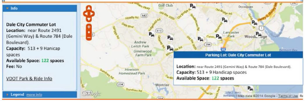
Figure 8: Real-time Parking Information Concept
The VDOT 511 web page currently includes the I-95 corridor P&R lot and VRE parking lot capacity, but not availability information. As part of the NOVA RMI, VDOT plans to deploy systems to collect real-time parking availability information that will be provided the VDOT 511 system. Figure 8 illustrates how the real-time parking information will be provided to travelers.
VDOT P&R facilities that will be included in NOVA RMI are:
- Falmouth – Constructed to support the Express Lanes with 1024 parking spaces. The proposed strategy is to encourage Fredericksburg drivers to park their cars at this lot before reaching I-95.
- Courthouse – In proximity to I-95 with 534 spaces this lot is not fully utilized by AM commuters as many commuters prefer to park at the 2 lots off Garrisonville Road. The proposed strategy is to encourage Fredericksburg drivers to park their cars at this lot before reaching I-95.
- Garrisonville – Key parking location for accessing Express Lanes with 926 spaces. A Travel Time and parking information signing concept was developed in 2013 with replacing "I-95 HOV" with "EXPRESS LANES."
- South Commuter – Key parking location for accessing Express Lanes with 926 spaces. A Travel Time and parking information signing concept was developed in 2013 with replacing "I-95 HOV" with "EXPRESS LANES."
5.4. Disadvantaged Community Support
Across the NOVA region, there are residents that are economically disadvantaged. The problem is particularly acute along parts of the US-1corridor. Many residents in this area are highly dependent on transit for access to jobs and services, both inside and outside the corridor. Some do not have access to private vehicles or smartphone technology, and are limited in their ability to walk long distances. Consequently, these residents are lacking in access to accurate, real-time information on public transit services and are often stymied in their ability to travel by a dearth of first-mile/last-mile connectivity to public transportation.
To address these issues, the NOVA RMI will undertake the following in the US-1 corridor:
- Install transit information kiosks at strategic locations along the corridor, including employment resource centers, shopping areas, shelters, etc.
- Establish a pilot program to assist residents who are dependent on transit with first-mile/last-mile support to reach employment locations and attend job training.
5.5. Stakeholder Outreach
Stakeholder and community outreach is an essential element of the NOVA RMI. It is necessary to ensure that program needs and expectations are clearly articulated, and that partners, third-party providers, and transportation customers have sufficient information to be supportive of the program. Outreach is planned on three levels:
- Third-party traveler information providers. The concept here is to furnish guidance materials – and convene workshops to discuss – regional ICM program needs and expectations regarding traveler information. The assumption is that if providers understand what the region is seeking to accomplish with traveler information, they will best be able to accommodate those needs. Additionally, providers may have ideas and insights to make the ICM program stronger. Regardless, both the region and providers are likely to have data of that will be of interest to one another.
- Communications companies. The process here is similar to that described above – namely to educate communications companies on regional needs and plans, and seek out these firms support, notably in the area of 5G communications support. This is an opportunity for win/win outcomes in the context of public/private partnerships.
- Citizen outreach. Program materials and informational meetings will explain ICM concepts in plain-English, and discuss the relationship between the ICM program and the other transportation initiatives across the region.
The overarching theme behind the outreach effort is that when stakeholders are knowledgeable and empowered, they will be best positioned to be part of our transportation solutions.
6. Deployment Plan
The NOVA RMI will build upon the foundational planning that has been conducted through the completed ICM planning activities. The development and deployment of the initiative is divided into three phases:
- Design – Entails the development of the Systems Engineering Management Plan (SEMP), including Systems Requirements Specifications and Detailed Design document. (Concepts of Operations were previously completed for the I-95/I-395 Corridor and East-West Travel Shed.)
- Development and Testing – Primary activities include the development and testing of the Enhanced DSS, Regional Data Warehouse and Portal. During this phase, VDOT will take the necessary steps to ensure the functionality, reliability and long-term sustainability of the technologies to be deployed.
- Deployment and Operations – During this phase, VDOT will conduct component-level, end-to-end, and system-level testing. This phase also entails the deployment and sustained operations of the system.
VDOT expects that both the technical approach and plan for deploying the NOVA RMI will be a model for the other regions in Virginia and the nation that aspire to develop, deploy, and operate a regional ICM. VDOT is a participant in the I-95 Corridor Coalition and can provide the framework from its program toward development of a larger corridor ICM program. VDOT is committed to not only the sustained operation of the NOVA RMI, but also the continual enhancement and expansion of the technologies.
6.1. Deployment Obstacles
No obstacles are identified that would hinder the development, deployment, and sustained operations of the NOVA RMI. To a substantial degree, the institutional issues that may have arisen were identified and mitigated through the planning conducted under the FHWA-funded ICM Planning Grant. The ICM planning process has been characterized by collaboration, and broad-based regional support. To help foster collaboration throughout the planning process, seven agencies partnered, in the form of a Program Advisory Group (PAG), to advise and guide the planning process. These agencies are: (1) VDOT, (2) the Virginia Department of Rail and Public Transit (DRPT), (3) NVTA, (4) the Washington Metropolitan Area Transit Administration (WMATA) which operates the Metro Rail and Metro Bus systems, (5) the Metropolitan Washington Airports Authority (MWAA), which operates the Dulles Toll Road, (6) Arlington County, representing local jurisdictions across the ICM study corridor and (7) FHWA. A broader team of regional stakeholders, known as the Stakeholder Coordinating Committee (SCC), has served as the coordinating body for developing the ICM concept. Members of the SCC include local departments of transportation, transit agencies, incident managers, regional planning entities, neighboring states and jurisdictions, and others. The stakeholder groups are shown in Figure 2.
6.2. Deployment Readiness
VDOT recognizes the development, deployment, and operation of ICM is a significant step forward in enhancing regional mobility. The US DOT ITS Joint Program Office has developed a list of attributes of successful ICM sites.5 These attributes as they relate to VDOT's proposed NOVA RMI are:
- Significant Congestion and Unreliable Travel Times
- Centralized Data Hub
- Successful Procurement Practices
- Readily Available Alternative Transit Options
- Infrastructural Availabilities
- Multimodal Capabilities
- Optimization of Existing Transportation Systems
- Public Engagement
- Open-mindedness for Change
- Institutional Support
7. Regulatory, Legislative, or Institutional Challenges
There are no regulatory or legislative issues that impede or prohibit the development, deployment, and sustained operations of the NOVA RMI. As mentioned, institutional challenges have been mitigated through the extensive planning that has been conducted through the ICM Planning Grant. Cooperation and collaboration will be further solidified through the signing of MOUs with partner agencies following the grant award.
8. System Performance Improvement
ICM, which is a focal point of the NOVA RMI, is viewed as an emerging approach to address congestion and travel-time issues, not only at the corridor-level, but increasingly at the regional level. The expected primary benefits to be derived from the deployment of the NOVA RMI are:
- Enhanced Mobility – Measured in terms of travel-time, delay, and throughput.
- Travel Time Reliability – Defined as the total observed travel time less the travel time under uncongested conditions, and is reported both in terms of vehicle-hours and person-hours of delay.
- Throughput – Throughput is measured by comparing the total number of vehicles entering the network and reaching their destination within the simulation time period.
US DOT-sponsored research using modeling and simulation suggests that the potential benefit-cost ratio of ICM solutions range from 10:1 to 25:1 over a 10-year period.6 Likewise research conducted by the University of Virginia indicates that ICM deployments along the I-95 corridor in the Commonwealth would result in a travel time reductions of 3-10%. Assuming a conservative 3% improvement in travel time, there would be an estimated reduction of 307,000 hours of vehicle delay in the Northern Virginia region. This equates to a $10.5M in savings/year lost time and wasted fuel.
9. Vision, Goals, and Objectives
VDOT's stated mission is to plan, deliver, operate and maintain a transportation system that is safe, enables easy movement of people and goods, enhances the economy and improves the quality of life. The NOVA RMI shares this mission.
As it relates to the NOVA RMI, VDOT's goals are to:
- Optimize performance of the existing infrastructure – Ensures that all elements of the transportation infrastructure perform at peak efficiency.
- Enhance travel time reliability in the study area – Improves the accuracy of travel time prediction, such that the amount of time needed to complete individual trips in or through the study corridor can be more effectively judged.
- Support on-demand, multi-modal trip options for travelers – Requires furnishing timely, detailed, actionable information to travelers to guide them in making "intelligent" travel choices.
10. Partnership Plan
VDOT, DRPT, and NVTA are joining together to implement the NOVA RMI; the Program Management Agreement for accomplishing this may be viewed in Volume 2 of this submission. Stakeholders across the region will be part of the deployment/operations process. These stakeholders have participated in the ICM planning process and will join in a memorandum of understanding (MOU) following grant award. Letters of support from key stakeholders are also included in Volume 2.
As noted, VDOT will continue leveraging its resource-sharing agreements with telecommunications providers. In particular, VDOT has in place a resource-sharing agreement with Verizon Communications, which will be used to advance the 5G communications program discussed in this application.
VDOT also has data-sharing agreements with Inrix, Waze, RITIS, and others. VDOT is a partner in the Metropolitan Area Transportation Operations Coordination (MATOC) program. VDOT also has partnership relationships with the University of Virginia (to jointly operate the Virginia Transportation Research Council) and the Virginia Tech Transportation Institute, including operating the Virginia Connected Corridors initiative.
11. Leverage Existing Investments
The development and implementation of the NOVA RMI provides the opportunity to leverage the functionality of a range of transportation technology investments in the region. These include, but are not limited to:
- Freeway and Arterial Infrastructure – ITS devices have been deployed by VDOT and other jurisdictions along the corridor, including cameras, dynamic message signs, traffic sensors for counting and classifying vehicles, and roadside weather information system devices.
- Connected Vehicles – The Virginia Connected Corridors initiative is facilitating the real-world development and deployment of connected-vehicle technology using roadside equipment units (RSUs) and highly instrumented vehicle fleets.
- Virginia Automated Corridors (VAC) Initiative – Aims to streamline the use of Virginia's roads and state-of-the-art test facilities for automated vehicle testing, certification, and migration toward deployment.
- Signal Controller and Communications Upgrade – Northern Region Operations (NRO) is upgraded all traffic signal controllers and communication to type 2070 ATC controllers and Ethernet broadband communications.
- Closed Circuit Television (CCTV) – NRO has deployed hundreds of CCTV cameras along interstate facilities with nearly 100 percent viewing coverage, and over 80 intersections.
- Uninterruptable Power Supply (UPS) – To preserve continuous signal operations during power outages, NRO has taken a phased approach to furnishing and installing a true-on-line, power conditioner and digital signal processor (DSP) UPS system designed for transportation and traffic applications.
- Extension of I-95 Express Lanes – The I-95 Express Lanes will be extended 10 miles south to Fredericksburg to alleviate backups at the current southern terminus.
- Deployment of New 511 System Features – To promote multimodal options and advanced travel time estimation features. Promotes traffic demand management capabilities to control traffic volume.
- I-66 Express Lanes (Inside the Beltway) – Conversion of I-66 east of I-495 to dynamically-priced toll lanes during rush hours in the peak directions where HOV vehicles and buses will travel the lanes for free, while others will be required to pay a toll.
- I-66 Express Lanes (Outside the Beltway) – As part of a private-public partnership initiative, reconstruct I-66 between US 15 (Exit 40) in Haymarket and I-495 (Exit 64) in an effort to transform the corridor into a much more multi-modal corridor.
- I-495 Express Lanes – HOT Lanes deployed on a 14-mile segment of I-495 extending from the Springfield Interchange to a point north of the Dulles Toll Road.
- I-395 Express Lanes – Convert the existing reversible high-occupancy vehicle (HOV) lanes from near Alexandria to Washington, DC.
12. Schedule
12.1. Deployment Schedule
VDOT recognizes that the NOVA RMI deployment schedule is aggressive. However, developing, deploying, and operating the proposed services within the planned time-frame is achievable given the significant amount of upfront planning that will be leveraged. Table 3 provides an overview of VDOT's deployment schedule.
13. Support of USDOT ITS Initiatives
The NOVA RMI supports US DOT research, development and deployment activities across a range of "strategic priorities and themes" per the ITS Strategic Plan 2015-2019, including:
- Enhance Mobility by exploring methods and management strategies that increase system efficiency and improve individual mobility.
- Limit Environmental Impacts by better managing traffic flow, speeds, and congestion, and using technology to address other vehicle and roadway operational practices.
- Promote Innovation by fostering technological advancement and innovation across the ITS Program, continuously pursuing a visionary/exploratory research agenda, and aligning the pace of technology development, adoption, and deployment to meet future transportation needs.
- Support Transportation System Information Sharing through the development of standards and systems architectures, and the application of advanced wireless technologies that enable communications among and between vehicles of all types, the infrastructure, and portable devices.7
In addition, the NOVA RMI is in step with many of the Program categories detailed in the plan, including:
- Interoperability: Essential to ensure effective connectivity among devices and systems.
- Enterprise Data: With increased connectivity among vehicles, organizations, systems, and people, unprecedented amounts of data are being generated. These activities also focus on enhancing the creation of data environments that enable integration of data from multiple sources for use in transportation research, management, and performance measurement.
- Interoperability: Essential to ensure effective connectivity among devices and systems. Interoperability focuses on enabling ITS elements in vehicles, devices, infrastructure, and applications to effectively communicate with other parts of the system as needed, regardless of where they are built and where or when they are used.
- Accelerating Deployment: Address questions associated with adoption and deployment. Adoption includes the phase after testing, when technologies are ready for initial implementation in the "real world."8
It is also important to note that the NOVA RMI leverages the institutional collaboration facilitated through the US DOT-funded Northern Virginia East-West ICM Corridor Planning Study. It builds on the ICM work previously completed by VDOT and its regional partners, including preparation of concepts of operations and implementation plans in for the I-66 and I-95 corridors.
1 See https://thenovaauthority.org/about/. [ Return to Note 1 ]
2 The Project Management Body of Knowledge (PMBOK) is a set of standard terminology, processes, and guidelines for project management. The body of knowledge evolves over time and is presented in A Guide to the Project Management Body of Knowledge which is sanctioned by the Project Management Institute. [ Return to Note 2 ]
3 Texas A&M Transportation Institute and INRIX, 2015 Urban Mobility Scorecard, p. 18. [ Return to Note 3 ]
4 Virginia Department of Transportation, Northern Virginia East-West ICM Corridor Planning Study: Concept of Operations, February 2017, p. 3. [ Return to Note 4 ]
5 United States Department of Transportation – Intelligent Transportation Systems Joint Program Office. Integrated Corridor Management – 10 Attributes of A Successful ICM Site. https://www.its.dot.gov/factsheets/pdf/ICM_10Attributes.pdf [ Return to Note 5 ]
6 https://www.itsknowledgeresources.its.dot.gov/its/bcllupdate/pdf/BCLL_Freeway_ICM_2014_FINAL.pdf [ Return to Note 6 ]
7 United States Department of Transportation – Intelligent Transportation Systems Joint Program Office. ITS 2015-2019 Strategic Plan. Pp.V [ Return to Note 7 ]
8 United States Department of Transportation – Intelligent Transportation Systems Joint Program Office. ITS 2015-2019 Strategic Plan. Pp.VI [ Return to Note 8 ]