ATCMTD Proposal: Central Valley Gateway ITS Project
Printable Version [PDF, 2.7MB]
You may need the Adobe® Reader® to view the PDFs on this page.
Contact Information: Operations Feedback at OperationsFeedback@dot.gov

U.S. Department of Transportation
Federal Highway Administration
Office of Operations
1200 New Jersey Avenue, SE
Washington, DC 20590
Project Narrative
BACKGROUND
Nearly a decade ago, three MPOs comprising the Lower San Joaquin Valley of California and the California State Department of Transportation (Caltrans) came together to finalize a plan for their backbone surface transportation network. The Counties were Merced, Stanislaus and San Joaquin at the northern end of the San Joaquin (Central) Valley. With each County experiencing active and sizable growth, they shared a common vision of congestion management featuring ITS. Ambitious in its scope, the resulting Plan1 called for integration of intelligent vehicle systems into the existing and future highway and local street and road networks.
Subsequently, ramp meter and HOV elements were incorporated into the Regional Transportation Plans of each of the MPOs2,3,4. These elements were also incorporated into Caltrans planning documents5,6.
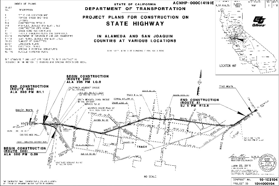
In 2010, the California Department of Transportation (Caltrans) began designing the first Phase of the I-205 SMART Corridor (cf. Figure 1). Phase 1 construction started in late 2015 and is expected to be complete in August, 2017. Phase I installed fiber optic trunk lines, loop detectors, changeable message signs (CMS), closed-circuit television (CCTV), roadside weather information stations (RWIS), along a 15 mile stretch of I-205 between I-5 and I-580.
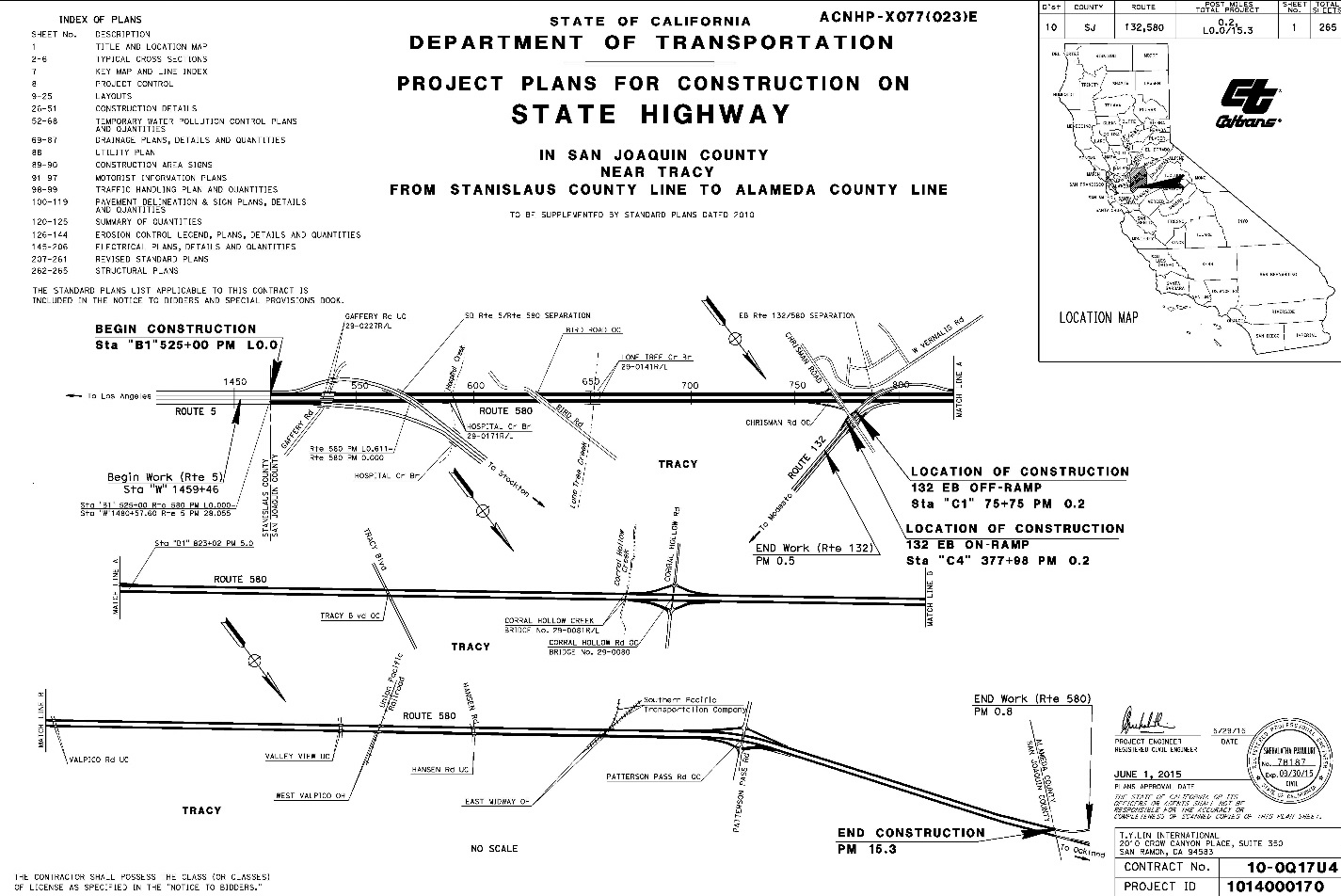
Similar ITS elements were planned for and designed along I-580 in San Joaquin County (cf. Figure 2). These elements began construction in early 2016 and are expected to be complete in October, 2017.
Together, these 2 ITS route segments funnel large amounts of commuters and freight on a daily basis into and out of the San Francisco Bay Area – a haven for employment centers – and expensive housing.
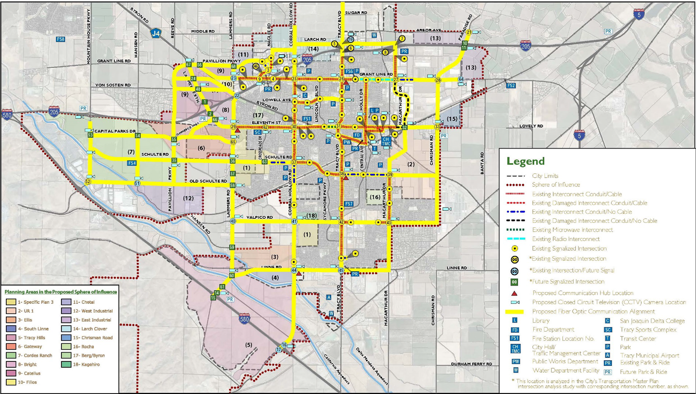
Within the County of San Joaquin, individual communities have also added ITS elements to their transportation system. The City of Tracy in western San Joaquin County is no exception. Their ITS vision
is carefully included in their Transportation Master Plan.7 A schematic of the vision is provided in Figure 3 on the next page.
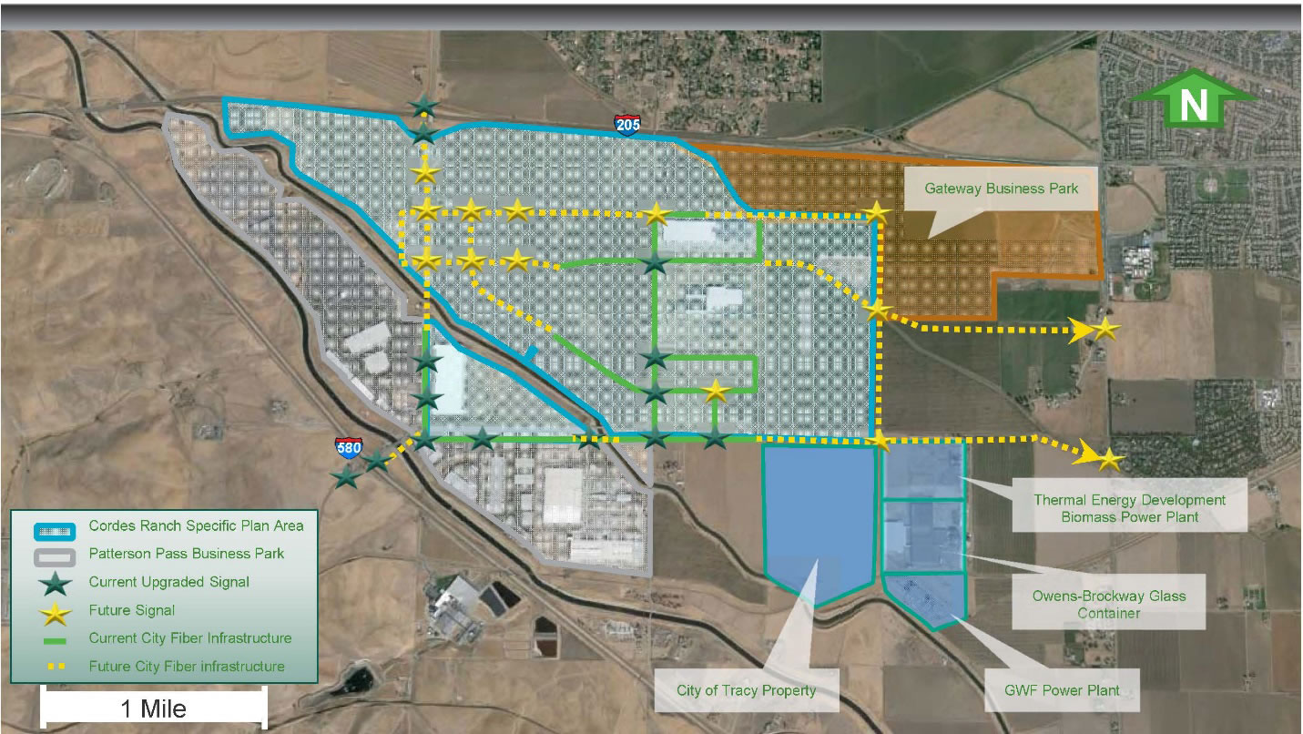
The western portion of the City of Tracy was planned largely through the Cordes Ranch Specific Plan.8 Given the Ranch's proximity to both I-205 and I-580, the site is ideal for both long-haul freight warehousing and short haul trans-shipment. As the majority of the property is being developed for commercial and industrial land uses, truck volumes are anticipated to become relatively high. The ITS component of this development is designed to complement the City of Tracy and Caltrans design. A schematic depicting ITS deployment throughout Cordes Ranch is presented as Figure 4, above. Both the I-205 and I-580 corridors are major arteries between residential communities of the Central Valley and the employment centers of the San Francisco Bay Area. It is also a primary freight corridor between the agricultural producers of the Great Central Valley of California, the port of Oakland, and San Jose Mineta International airport.
PROJECT SCOPE
Our project proposes to connect the rapidly growing western City of Tracy street-and-road network to the larger San Joaquin County and Central Valley transportation network (cf. Figure 4). The project also proposes to provide major components of the Phase 2 ITS build-out along I-205 between the junctions of I-5 and I-580. Connections will be made to both the City of Tracy Traffic Control Center (TCC) and the Caltrans District 10 Transportation Management Center (TMC). Freight haulers will collect freight data arriving and departing their terminals within Cordes Ranch.
Phase 2 of the I-205 SMART Corridor is in the preliminary engineering phase. The current schedule anticipates construction to begin in June, 2019. Completing these installations will connect the Central Valley gateway ITS system to the larger Caltrans SMART network to the west in Alameda and Santa Clara Counties, and the expanding toll lanes along both I-580 and I-680.
TECHNOLOGIES
Fiber optic trunk lines, ramp meters, closed circuit television cameras (CCTV), changeable message signs (CMS), and loop detectors will be employed in the field, along with several monitors and desktop computers at the TCC and TMC. Global positioning system (GPS) detectors will be used for mobile applications in freight haulers and shippers.
BENEFITS
Emergency response times for emergency vehicles (fire engines, paramedics, ambulances) and law enforcement (Highway Patrol, County Sheriff, City Police) will improve as a result of TCC and TMC connectivity. This correlates to sizable safety benefits which can be easily quantified using the Cal B/C model. Treatment for injuries sustained in motor vehicle accidents will be more quickly administered, insuring better survival rates and also improving safety in quantifiable fashion. Traffic congestion and delay times will be reduced as a result of real time travel information. As a consequence, air quality will improve and GHG emissions will be reduced as a result of real time travel network updates, enabling travelers to take alternate routes during congested peak hours, not to mention lowering fuel consumption and operating costs. Health benefits for asthma suffers will result – again resulting in quantifiable benefits using the Cal B/C model. Shipping data will be used to assist in formulation of a sinking fund to address development of either (a) westbound express lane extensions from Livermore (over the Altamont Pass on I-580 in Livermore) or (b) a dedicated truck climbing lane – possibly with freight tolling.
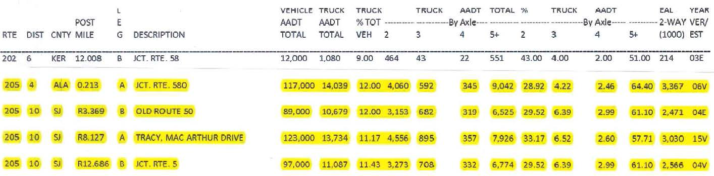
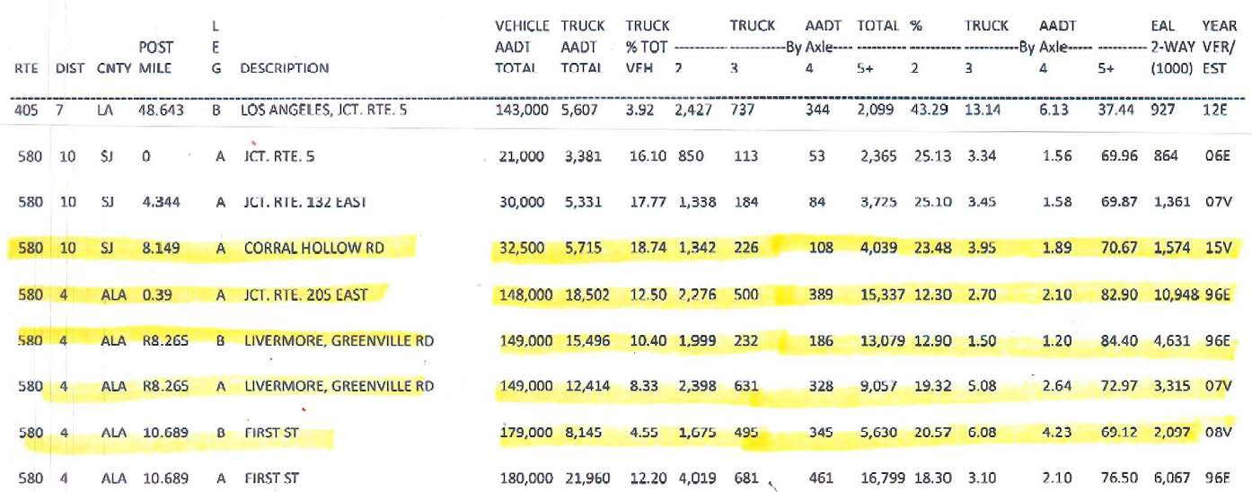
While at this time real-time data collection, origin-destination, time-of-day departures and arrivals, and average running speeds are the sole freight aspects of this ITS application, they can directly contribute to the broader NorCal (and statewide) goods movement applications. Relevant tallies of existing truck counts by Caltrans on both I-205 and I-580 are reflected in the yellow highlights of Figures 5 & 6.
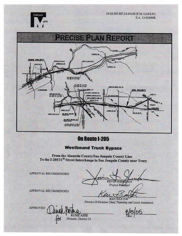
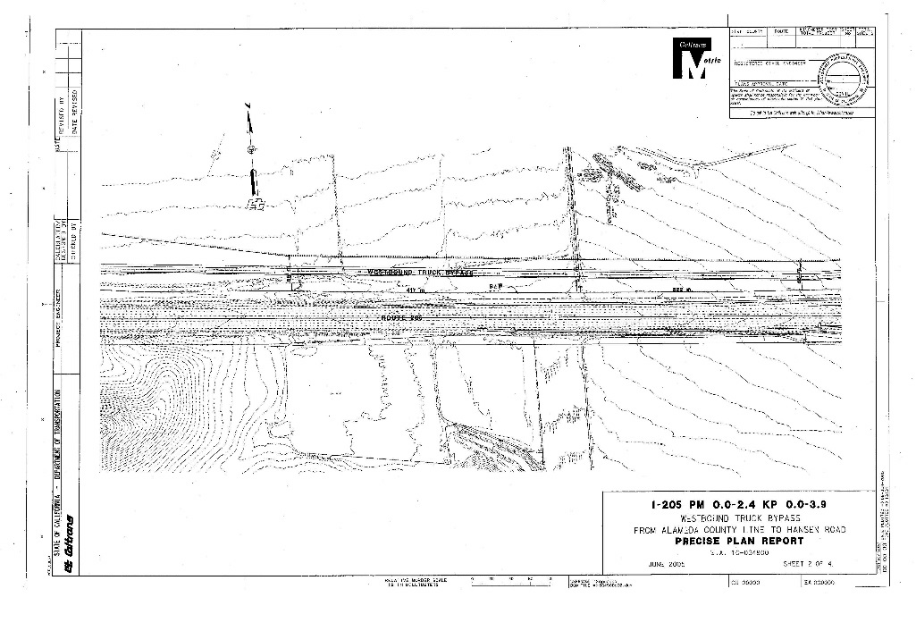
Caltrans has for many years considered the development of westbound truck climbing lanes between western Tracy and the Altamont Summit in Alameda County. Towards this end a Precise Plan Report was prepared in 2005 including cost estimates (cf. Figure 7). Base maps were also prepared to accompany the infrastructure scope (cf. Figure 8). Preliminary data from companies with warehouse located in Cordes Ranch indicates both an interest on the part of shippers for a more integrated strategy and a willingness to pay for it.
Cordes Ranch is strategically situated just beyond the Alameda County/ Metropolitan Transportation Commission (MTC) boundary. While historically, Alameda County has been resistant to any notion of opening up what they perceive to be 'their' gateway to the SF Bay area for more (westbound) trucks, quality emissions which westbound trucks contribute to their County. Ongoing dialogue across MPO boundaries in the form of the California Sustainable Freight Action Plan, the California Freight Advisory Committee (CFAC), and the CUFC/CRFC Technical Working Group9 provide the perfect opportunity for the development of a common understanding of the mutual benefit of intra-regional cooperation between the SF Bay Area and the California Central Valley, the MPOs of record (MTC and SJCOG), and the two Regional Air Quality Management agencies (BAAQMD and SJVAPCD).
Trucks leaving facilities in western Tracy and western San Joaquin County are subject to indirect source reduction fees for the San Joaquin Valley Air Pollution Control District (SJVAPCD), yet because their mileage within the San Joaquin Valley (Central Valley) is minimal, their contributions for air quality mitigation is nominal. At the same time with a large plurality of their trips either end at the Port of Oakland or elsewhere within the 9-County SF Bay Area, and a large percentage of their operating costs being in the form of personnel time under union contracts, these companies would be willing to pay modest fees for their shipments in Alameda and other Bay Area Counties if in return they could expect to have quicker, more efficient shipping times by virtue of dedicated truck lanes. To extend the (existing) toll lanes for mixed flow traffic in the westbound direction would also serve the same purpose as the absolute number of vehicles remaining in mixed flow lanes which trucks would have to contend with would be reduced under a tolling scenario.
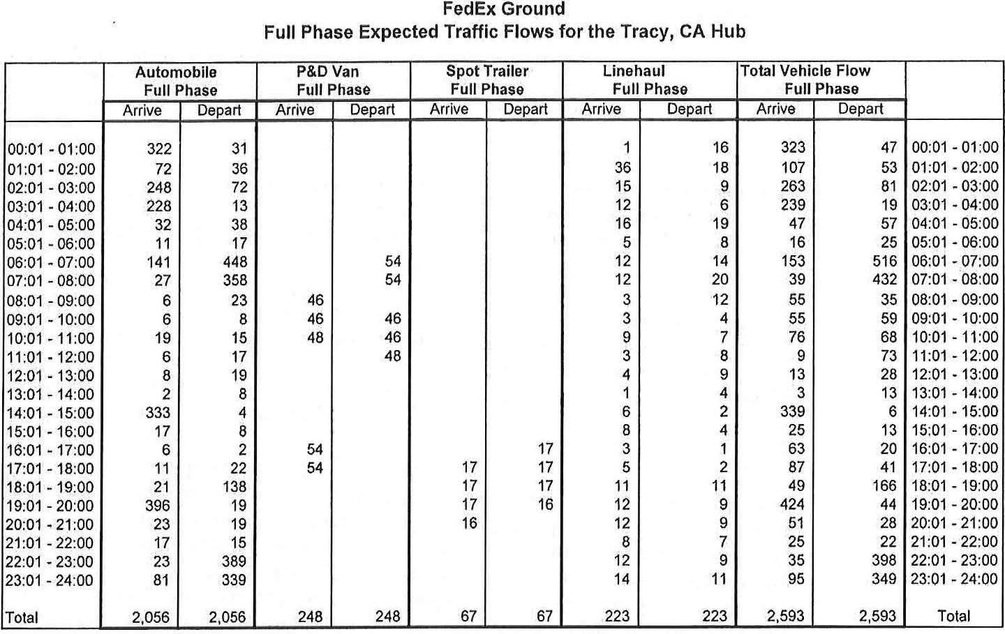
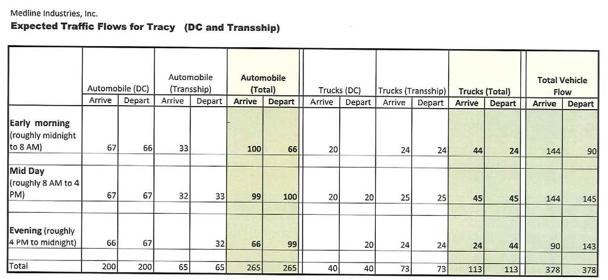
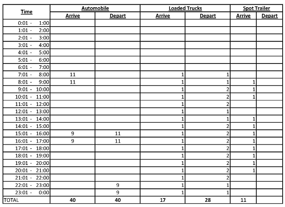
Preliminary data from Amazon, FedEx, Medline, Safeway, and Costco warehouses and e-commerce Fulfillment Centers within and in proximity to the Cordes Ranch development demonstrate the potential for freight improvements (cf. Figures 9, 10 and 11). Sizable efficiencies can be realized by harnessing the potential of gps tracking, routing, and real time dispatching.
1 Northern San Joaquin County Valley Ramp Meter and HOV Master Plan, DKS & Associates, 2009, www.sjcog.org [Return to Note 1]
2 Merced County Association of Governments RTP, www.mcag.org , 2010 and 2014 [Return to Note 2]
3 Stanislaus Council of Governments RTP, www.stancog.org , 2011 and 2014 [Return to Note 3]
4 San Joaquin Council of Governments RTP, www.sjcog.org , 2011 and 2014 [Return to Note 4]
5 Caltrans DSMP, www.dot.ca.gov/dist10/divisions/Planning/docs/D10FinalDSMPSeptember2010.pdf, 2010 [Return to Note 5]
6 Caltrans I-205 Corridor System Management Plan (CSMP), www.dot.ca.gov/hq/tpp/corridor-mobility/CSMPs/d10_CSMPs/I-205%20I-5/d10_csmp_i205_i5.html , 2012 [Return to Note 6]
7 Transportation Master Plan, City of Tracy, www.thinkinsidethetriangle.com/?navid=2101, Ch. 4.9, 2012 [Return to Note 7]
8 Cordes Ranch Specific Plan, City of Tracy, www.thinkinsidethetriange.com/?navid=595#3280 , 2013 [Return to Note 8]
9 California Sustainable Freight Action Plan, www.dot.ca.gov/hq/tpp/offices/ogm/index.html [Return to Note 9]