City of Sacramento, California: ATCMTD Initiative - Volume 1 Technical Application - Connect the Grid 1.0
Project Description
1. Introduction
The City of Sacramento (City) is continually enhancing its existing infrastructure and systems to evolve Sacramento into a truly Smart City. The City is a regional leader in developing and deploying advanced technologies that enhance mobility, improve safety, and reduce traffic congestion for residents, commuters, and tourists alike. The City has invested significant effort in the development of smart city technologies. Sacramento's Smart City Challenge bid sought to deploy smart detection and connected infrastructure at traffic signals, create a regional transportation app to assemble transportation information into an intuitive platform for its users, and develop a fleet of autonomous electric transit vehicles.
These initiatives remain important to the City, as evidenced by Mayor Darrell Steinberg recent announcement regarding the formation of the Autonomous Transportation Open Standards (ATOS) Laboratory. This lab establishes a national testbed for autonomous vehicle innovation in Sacramento at the doorstep of the State Capitol, the birthplace of vehicle licensing and regulation in California. This puts the City in prime position to deploy connected vehicle infrastructure technology to synergize data collection sources, enable integral implementation of forward-thinking initiatives, and facilitate and showcase exciting advancements being envisioned today.
To combat the challenges the City faces today and prepare for those of tomorrow, the City has established the following goals for the various levels of the transportation system:
- Citywide Level: Develop and deploy a cloud-based performance management platform and data aggregator framework for travel data collection, storage, analysis, and public dissemination.
- Project Limits Level: Improve travel time reliability, increase transit utilization, enhance safety for all travel modes, and quantify performance of the transportation system.
- Corridor Level: Improve corridor management by creating efficient travel corridors, accommodating special events, reacting to incidents, and reducing congestion.
- Intersection Level: Improve individual traffic signal performance to optimize throughput and enhance safety for bicycles and pedestrians.
- User Level: Facilitate user access to pertinent traffic data that enables efficient mobility options.
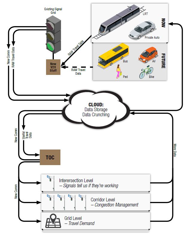
With aid from the Advanced Transportation and Congestion Management Technologies Deployment Initiative, the City seeks to develop an advanced transportation system that collects real-time high resolution traffic data, compiles and analyzes these inputs, generates performance data, and provides outputs that can be used through vehicle-to-vehicle (V2V), vehicle-to- infrastructure (V2I), and vehicle-to-pedestrian (V2X) solutions and mobility applications. The City has dubbed the development of this system Connect The Grid 1.0, aligning the first phase deployment with the City's Grid 3.0 initiative.
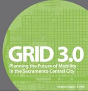
Grid 3.0 is a strategic growth and integration plan whose overarching goal is to define an integrated package of transportation improvements that will enable downtown Sacramento to retain and reinforce its role as the Region's primary hub as it experiences significant growth in housing, employment, entertainment, sports, and cultural uses over the next two decades. The objectives are as follows:
- Create a well-connected transportation network
- Support increased density of mixed-use development in multimodal districts
- Support bicycling
- Improve transit
- Conserve energy resources
- Reduce GHG and air pollution
- Accommodate auto mobility
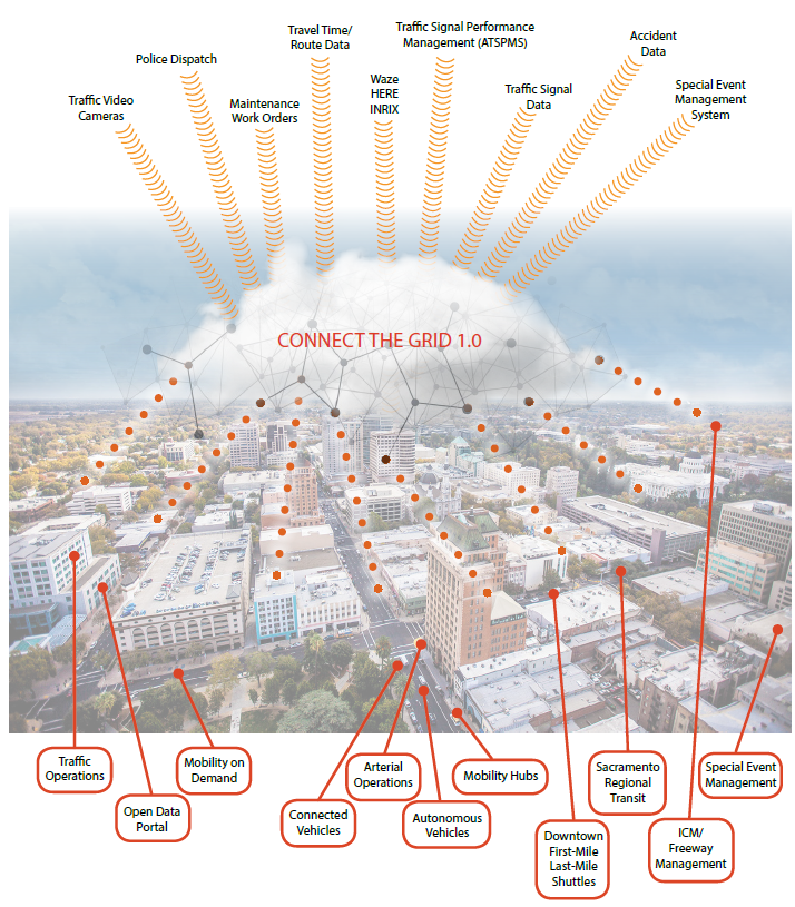
The cornerstone of Connect The Grid 1.0 is the development and deployment and deployment of a new cloud-based performance management platform that will aggregate current and future data streams (such as traffic signal data, bicycle and pedestrian counts, and accident data) and make them available to various public and private users. Data sources will be aggregated in a central database, processed and analyzed, then made available in specific reporting or exporting formats that allow end users to manipulate or use the data. this management platform will provide private-sector partners with the tools necessary to access and use the City's data on vehicles, transit, bicycles, and pedestrians to improve the dissemination of City information and innovate new services for the public.
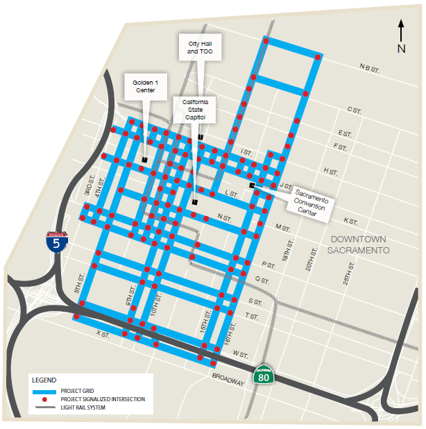
The City is very active in the implementation and evaluation of advanced systems to support traffic and transportation operations and management within the City, with the focus of mitigating congestion, assisting drivers to locate available parking spaces more effectively, and improving pedestrian and cyclist safety. The City is actively studying and testing several advanced transportation and congestion management technologies. These technologies include data collection systems utilizing Bluetooth, video analytics, and Wi-Fi. Testing new technologies is a solid first step, but the City needs assistance to implement and expand these systems to full deployment. As part of this project, the City will deploy this equipment at 116 signalized intersections to collect data on vehicle speed, travel times, congestion, delay, origin-destination, bicycles, and pedestrians, enabling it to perform informed short- and long-term planning to operate the transportation system as effectively as possible.
Sacramento is one of only 26 American cities with a true light rail system. This project aims to bring the City's light rail and streetcar systems into the 21st century and prepare them for the future by integrating both Regional Transit's light rail vehicles (LRVs) and the new Downtown/Riverfront Streetcar with the City's connected infrastructure. Regional Transit is planning the deployment of a new automatic vehicle locator (AVL) system that will outfit all LRVs with equipment capable of V2I communication. The deployment of the new Downtown/Riverfront Streetcar system is currently underway, creating a critical infrastructure component in the region's plan to meet mobility needs and reduce automobile congestion. Connections to these systems will provide real-time data in the form of location, route, station arrival, and station departures. Additionally, the LRV operator will receive traffic signal data including signal status, phase status, and priority or preempt confirmation.
The City envisions a future with smart technology and connected infrastructure deployed throughout the City limits. This project will install the foundation on which future deployments will be built and construct phase one of the City's smart transportation system. Phase one will encompass critical corridors in the central business district (CBD) of downtown Sacramento as well as parallel and connecting routes to US 50 located on the southern boundary of the CBD.
In summary, Connect The Grid 1.0 will develop an advanced transportation system with smart data collection capabilities, connected infrastructure and light rail vehicles, and a performance management platform. It will improve traffic safety and operations, communicate automatically with public transit, enhance pedestrian and bicycle facilities, interface with future US 50 Integrated Corridor Management (ICM) operations, accelerate the City's readiness for autonomous vehicles, and provide private sector partners with the tools necessary to access and use City data to innovate new, and improve existing, services. By initiating Connect The Grid 1.0, current data sources like traffic signal data, maintenance work orders, special events, and third-party traffic data will be aggregated and seamlessly available to inform users of services such as Regional Transit (bus and light rail), Mobility On Demand, Freeway Traveler Information, and the Regional Traffic Operations Center to create an environment that promotes advancement of new technologies, improves mobility services, enhances transit ridership, management of emergency situations, and well-informed drivers. This program will move the City toward achieving the following vision elements:
- Evolve mobility into an expectation of simplified mobility, shared mobility, reduced congestion, higher throughput, and broad mode choice
- Create a safer transportation network for vehicular traffic, transit (light rail and buses), bicycles, and pedestrians, starting in the Central Business District
- Optimize efficiency and improve travel reliability for the existing transportation network across all modes
- Enhance the City's readiness for autonomous vehicles, and propel current third-party visions Specific project elements and services are described in more detail under Item 5.
2. Entity Entering Into Agreement
The City of Sacramento is requesting Federal funding and will be the sole entity entering into the agreement with the Federal Highway Administration.
The City of Sacramento Public Works Department Transportation Division will lead and manage implementation efforts and coordinate the work of the region's best data and ITS technology consultants, vendors, and manufacturers. The City of Sacramento's Administrative and Fiscal Support Division will lead the management of the program funding and allocation.
3. Project Area
The City of Sacramento is the state capital of California and the seat of Sacramento County. The City is California's sixth largest with a total population of 466,488 within its city limits during the 2010 census. Sacramento is the fastest-growing big city in the state, and is the economic and cultural hub of the Sacramento metropolitan area which boasts a population of more than 2.4 million people. Sacramento offers its residents a tremendous quality of life while remaining the most affordable urban job center in California.
Downtown Sacramento encompasses 66 city blocks; receives over 100,000 employees daily; and bustles with over 200 bars and restaurants. Downtown Sacramento receives approximately 15.3 million visitors annually and is home to the California State Capitol, the Sacramento Convention Center, the Golden 1 Center, over 47 acres of urban parks, 12 museums, and 10 hotels. Redevelopment in downtown is progressing at a blistering pace with plans to build nearly 3,000 homes and 300,000 square feet of commercial space within the next five years.
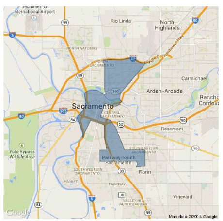
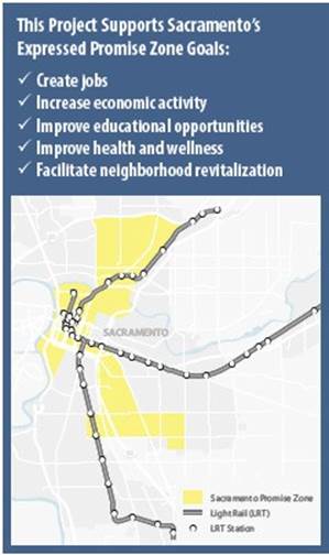
Sacramento has been identified as one of the most diverse cities in America. It is also one of a handful of cities receiving Promise Zone designation from HUD. The Sacramento Promise Zone encompasses some of the economically hardest-hit neighborhoods in the city – including a majority of the central business district and the US 50 corridor. More than 30% of residents in the Promise Zone have yet to achieve a High School diploma or GED. Nearly a quarter of the residents are foreign born with limited English proficiency. The Promise Zone has an alarmingly high unemployment rate of over 18% and a poverty rate hovering around 35%. This project, in conjunction with other initiatives, will enhance transit productivity of the region and set in motion a vital connection for disadvantaged communities to education and employment opportunity through a combination of autonomous vehicles and public-private partnerships with its many motivated partners.
This project will be deployed and operate directly around the California State Capitol, uniquely positioning Sacramento to demonstrate the projects' benefits, allow lawmakers to use the system, and inform the nascent regulatory dialogue about connected and autonomous vehicle standards.
4. Real World Issues and Challenges
As the City of Sacramento continues to grow, the strategies and improvements employed today are no longer effective in managing the issues and challenges facing the city. Redevelopment – including the Golden1 Center – the forthcoming development within the Railyards, and several major mixed-use developments in the downtown area will create a demand and expectation of efficient and reliable modal options. Traffic congestion, pedestrian safety, and the increasing bicycle community are no longer manageable through the archaic pre-timed signalized grid network in place today. Transit ridership has stagnated due to poor schedule reliability and ineffective service routes.
Capital improvements have been the primary method for handling growth, but these investments are no longer effective. With a fully built-out central business district and an underutilized transportation network, effective solutions must now focus on optimizing the existing transportation network and infrastructure. Technology in the form of smart intersection detection for all modes; a robust communications network that accommodates the demand for significant data collection and processing; smarter traffic signal controllers that intelligently adapt to demand from all modes; and on-board transit equipment to optimize service bus and light rail performance. These innovative strategies are part of Sacramento's future strategy to manage anticipated growth.
Traffic Congestion
Despite award-winning regional land use and transportation planning efforts, the City and region will suffer from increasing congestion. Congested vehicle miles traveled (VMT), which produces some of the highest levels of greenhouse gas (GHG), emissions are projected to increase over time. Congested facilities will also reduce travel reliability. By 2036, the Sacramento Metropolitan Transportation Plan (MTP) predicts that the majority of the regions' arterials and mainline freeways will have significant segments on which the peak hour volume exceeds capacity. Fuel consumption by vehicles driven in Sacramento is the single largest source of GHG emissions in the City, accounting for approximately 48 percent of the City's total GHG emissions. Transportation is expected to contribute over 2 million metric tons of carbon dioxide equivalent annually by 2020.
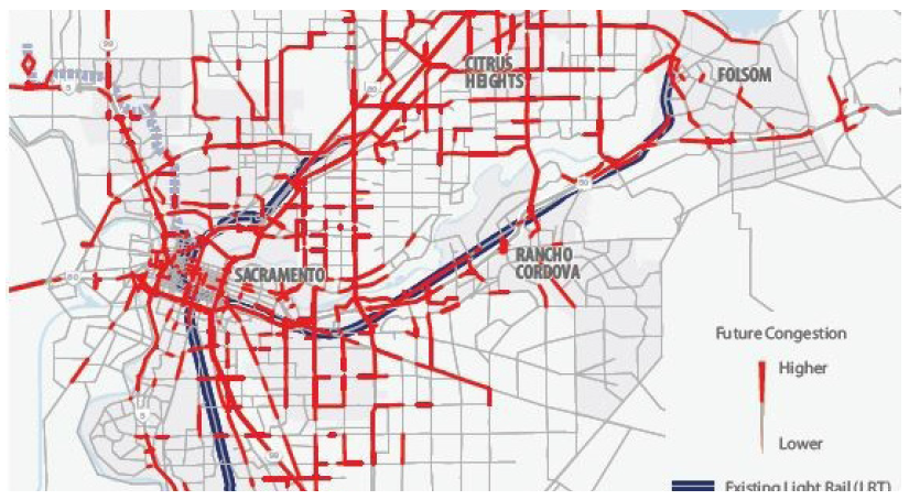
The City desires to address these issues by reducing congested VMT and the associated emissions aided in part through the deployment of smart technologies. In agreement with the Congestion Management Plan currently being finalized by SACOG, there is a strong need to implement connected infrastructure which aids in the reduction of congestion by allowing V2I interaction to improve operations and timing, gives priority to transit, and spurs innovation by collecting and disseminating real-time, real-world traffic data.
Growth and Redevelopment
Sacramento is the fastest-growing big city in the state, and its central business district, located downtown, is the economic and cultural hub of the region. In downtown Sacramento there are 2,775 homes and 285,475 square feet of commercial development that have received planning approval or have submitted applications. The projects include the Press Building (253 units) and 800 Block (148 units and 16,000 square feet of commercial). Additionally, in August of 2016 the City approved entitlements for the Downtown Railyards, which will allow 6,000 to 10,000 residential units; 3.271 to 4.371 million square feet of non-residential uses; 771,405 square feet of flexible mixed-use space; 485,390 square feet of historic and cultural space; a 1.228 million square foot medical campus; and a 1,100-room hotel. Currently, 756 homes and 238,742 square feet of commercial are under construction.
Transit Reliability and Utilization
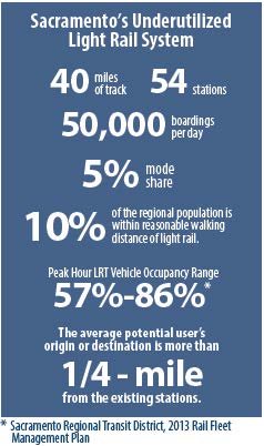
As one of the few regions in California that can still boast relatively affordable housing and robust employment growth, the Sacramento region, in partnership with the federal government, has invested heavily in creating a light rail system capable of providing an economical and convenient transportation option for residents of the greater metropolitan area. Sacramento has struggled to increase light rail mode share, in major part due to the "first-mile/last-mile" dilemma: while the light rail system provides an excellent regional transportation option, travelers who do not live and/or work close to a light rail station are significantly less likely to use the system. Instead, travelers are prone to use private automobiles for their work and recreational transportation needs.
With 40 miles of track and 54 stations, Sacramento's LRT system offers a fantastic opportunity as a transportation alternative. Presently, within the Regional Transit Service Area, approximately 10% of the regional population is within reasonable walking distance of light rail. While the system currently experiences approximately 50,000 boardings per day (approximately 5% mode share), the average potential user's origin or destination is more than ¼-mile from an existing station. Enhancement of the first-mile/last-mile services is key to increasing the utilization of the existing system. Enhanced service, coupled with future infill development plans as described in the region's Metropolitan Transportation Plan/Sustainable Communities Strategy (MTP/SCS), is an integral component in maintaining regional mobility and achieving the region's air quality conformity goals.
Social Equity
Almost 50% of all households in the City of Sacramento are considered low income, earning 80% or less of the area median income. Nearly 16% of City households have extremely low-income, earning less than 30% of area median income. The challenges faced by households with extremely low incomes are disproportionately felt among seniors (26%) and large families (30%). In 2015, a large portion of the City of Sacramento was designated as a federal Promise Zone. For the population in the Promise Zone, the poverty and unemployment rates are 34.4% and 18.1%, respectively.
With the elimination of redevelopment agencies in California in 2012, there are few tools to help municipal government provide ladders of opportunity to their disadvantaged neighborhoods. The City of Sacramento wishes to improve the public transportation system so it becomes a viable tool to provide convenient service to jobs, education, and medical care for the communities that need it the most.
5. Project Systems and Services
The project goals will be accomplished by deploying a series of strategies aimed at strengthening the foundation to increase functional capabilities including:
- Deploying advanced detection technologies to enhance vehicle and pedestrian detection, intersection control, and intersection safety;
- Establishing a cloud-based data storage bank for receiving, processing, analyzing, and disseminating data to and from field devices and users;
- Enhancing intersection control with smart intersections and connected vehicle technology to enhance system operations; and
- Implementing connected technology on light rail vehicles to promote higher transit reliability and ridership.
Each of these strategies will be integrated into a single system capable of expanding to accommodate new modules, new systems, and new users.
The primary strategies being deployed in Phase 1 are described below.
Expand the Existing Fiber Optic Communications Network
This project plans to use fiber optic cable for communications between field devices and the centralized management system due to high quantity of data that will be exchanged. The smart equipment installed at each traffic signal will communicate nearly constantly via the fiber optic cable to provide real-time traffic data to the system. In addition, the management system, as well as City staff in the Traffic Operation Center, will adjust the traffic signals when necessary over the same fiber. Fiber optic cable will provide unparalleled bandwidth, data rates, and reliability to the signal system.
The City has already made a considerable investment in developing a robust fiber optic communications network. The City has installed over 100 miles of fiber optic cable providing IP-based communications to over half of the City's traffic signals. This project will deploy connected infrastructure at 116 traffic signal in the downtown area. Of these 116 signals, 40 of them will require new fiber optic connections.
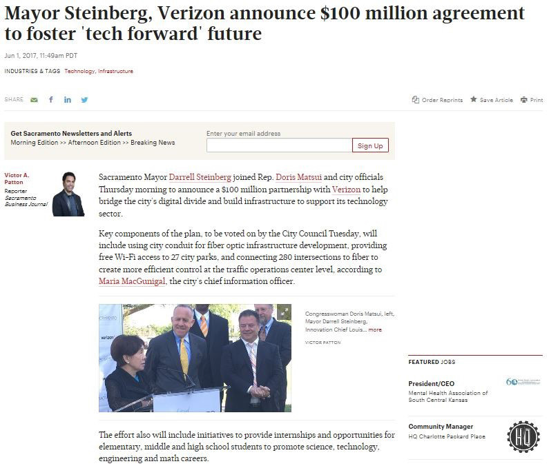
The City is currently working with Verizon as part of a public-private partnership to expand the City's fiber network. As part of this partnership, Verizon will connect 280 of the City's intersections with fiber optic communications and provide free Wi-Fi access to 27 city parks. The City will gain fiber connections to many of the offline project intersections, minimizing the need for ATCMTD Initiative funding to cover the cost of new fiber infrastructure.
Utilize Smart Detection at Traffic Signals
For the City to develop a smart signal grid and move towards becoming a Smart City, its intersections will need to be able to observe and collect pertinent information. The downtown grid, covering 66 square blocks, currently operates on fixed timing. With the introduction of smart detection, the grid will have the capacity to shift time between splits, adjust cycle lengths to accommodate demand, perform dynamic system response in coordination with neighboring intersections and crossing corridors, and collect quantitative performance measures.
This project will deploy smart detection capable of monitoring entire intersections – not just one lane or vehicle movement –as well as pedestrians and bicyclists. The City will collect data including, but not limited to, demand, vehicular volumes, bicycle volumes, pedestrian volumes, queue lengths, and light rail vehicle activity. This smart detection system will be capable of dynamically recognizing changing traffic conditions and request adjustments to signal timing as necessary.
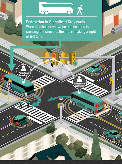
Connect The Grid 1.0 will deploy active pedestrian detection, which will work in unison with the connected infrastructure and eventually connected vehicles to activate pedestrian warning devices both at the intersection and within vehicles. Deploying this technology will increase the efficiency of signal operations, improve pedestrian safety, and open the door for pedestrian protection devices and technology currently under development such as driver warning, brake assist or automatic braking, and even external airbags or pop-up bonnets.
Sacramento's central business district sees dynamically different traffic conditions throughout the week that don't always adhere to typical time-of-day patterns. Traffic in the CBD can be characterized as either peak-hour, off-peak, or special event, but this characterization does not provide enough granularity to meet the City's operational goals. The newly opened Golden 1 Center, the City's Convention Center, and several museums located downtown host a myriad of conventions, exhibits, sporting events, and concerts at different times throughout the week, making planning for special event traffic extremely difficult with the City's current signal technology. The City's current system relies on a "one size fits all" approach that operates more as a "one size fits none" approach.
Deploying a smart detection system will allow the City to adapt to high pedestrian volumes that accompany special events such as basketball games and street fairs, as well as allowing it to monitor actual traffic conditions rather than relying on only modeled estimates.
Data Gathering and Analytics
The City currently collects only basic, low resolution data about the existing transportation network, but has goals of collecting higher volumes of high resolution data and developing a system to share it.
Sacramento partners with Waze, as part of the Connected Citizens Program, to help understand travel patterns as part of transportation planning and impact analysis. This information provides insight on traffic patterns and trends, but it doesn't go far enough.
To realize its goal of developing a truly advanced transportation system, City intersections and the roadway network must be able to collect data such as vehicle speed, travel time, congestion, delay, and origin-destination.
The City, through this project, plans to deploy an Automated Traffic Signal Performance Measure System (ATSPMS). In line with the FHWA's promotion, the City's planned system will provide the tools to overhaul its antiquated re-timing processes by providing continuous performance monitoring capability. Signal retiring efforts will be based directly on actual performance without the dependence on software modeling or expensive and time consuming manually collected data.
ATSPMS consists of a high-resolution data-logging capability added to existing traffic signal infrastructure and data analysis techniques. This provides the information needed to proactively identify and correct deficiencies in the system. In addition, the City will be able to manage traffic signal maintenance needs in a timely and effective manner to support its safety, livability, and mobility goals.
The technology is cost effective, as ATSPMS can be applied to a wide range of signalized intersections and use existing infrastructure to the greatest extent possible. ATSPMS will also support the validation of other technologies and operational strategies, such as adaptive signal control and connected vehicle applications.
Comprehensive and reliable real-time data will be collected from traffic sensors, signal control devices, and transit vehicles. Information about active incidents, construction and maintenance schedules, and other planned events will also be included. This data will allow for both short- and long-term transportation planning and precise fine-tuning of the signal system.
All collected data must be validated prior to use to ensure that erroneous information is not included in system evaluations. Data processing and analytics may involve the application of data fusion algorithms designed to address potential discrepancies among data collected from various sources and identify gaps in collected data. Once the information is compiled and screened, it can then be analyzed and disseminated. At this stage, the data will be made available to users in vehicles, on foot, on a bicycle, or at home. It will also be available to third-parties.
Implement a Performance Management Platform
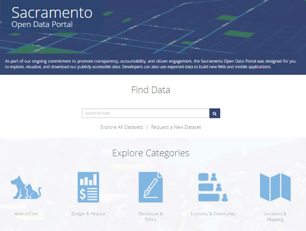
Once transportation network data is collected, it must be organized and processed effectively to reduce it into actionable information. Creating value from the mass of data the project will collect will be accomplished by a cloud-based performance management system. The planned system will interface with the existing Open Data Portal (http://data.cityofsacramento.org/) and include a data aggregator that will compile the City's existing and new transportation data streams into a single database. The system will use this aggregated data to determine user- defined outputs, providing critically useful real-time, real-world information.
The platform will also serve as the interface for disseminating the collected data to various public and private users. This management platform will provide private sector partners with the tools necessary to access and use the City's data to improve the distribution of City information and to innovate new services for the public.
The City anticipates providing data to the public and third-party users as real-time text (RTT), consistent with FCC 16-53. Real-time text is a mode of communication that permits text to be sent immediately as it is being created. It is designed for an IP environment and allows the use of off-the-shelf rather than specialized end user devices. The establishment of this data distribution system, as part of Connect The Grid 1.0, will help inform other cities and jurisdictions, and can be used as a model for others in the region.
Deploy Connected Infrastructure
This project will install communications technology at 116 traffic signals developing approximately 25 miles of smart, connected roadway grid. The connected infrastructure will enable signalized intersections to communicate with other traffic signals, vehicles, smartphones, and the central management system. Deploying connected infrastructure will allow the City to fully utilize all other tools developed as part of this project.
The City plans to deploy dedicated short-range communication (DSRC) equipment and smart controllers at signalized intersections allowing for real time traffic management, infrastructure to infrastructure data exchange, and vehicle to infrastructure data exchange. While traditional vehicles, connected vehicles, cyclists, and pedestrians will benefit from this connected infrastructure, autonomous vehicle operation has been shown to improve significantly with connectivity. Establishing connected infrastructure in the downtown grid, in addition to the ATOS lab, puts the City right where it wants to be – leading the region towards unrestricted autonomous vehicle deployment.
In addition to the future support for autonomous vehicle operation, smart controllers will be designed to provide real time traffic management, transit signal priority, and communicate directly with the City's Traffic Operations Center (TOC).
DSRC and smart controllers managing traffic in real-time and communicating with vehicles are deployed in experimental applications in many locations around the nation. The Sacramento project will rely on these proven technologies to create the communication link between the different pieces of the puzzle and combine them to build a truly smart transportation system.
Connect Transit Vehicles
Connect The Grid 1.0 includes several elements that will integrate with Sacramento Regional Transit to create better performance reliability and encourage increased ridership. This project will integrate Sacramento Regional Transit District's light rail vehicles (LRVs) and the new Downtown/ Riverfront streetcars with the City's connected infrastructure and management system.
Sacramento Regional Transit (RT) is planning deployment of a new automatic vehicle locator (AVL) system that will outfit LRVs with equipment capable of V2I communication. LRV arrival predictions are currently schedule-based but the new AVL system will allow real-time predictions.
The Downtown/Riverfront Streetcar is a critical infrastructure component in the region's plan to meet mobility needs, reduce car congestion, and to reach the region's greenhouse gas reduction and air quality targets. The system includes nineteen stops on a 3.3-mile loop with six streetcars deployed with equipment supporting integration with connected infrastructure.
Connect The Grid 1.0 will integrate with transit equipment to develop V2I communications to capture real-time, on-board data to establish arrival and departure predictions, initiate transit signal priority (TSP), and provide RT's operators valuable decision-making information.
6. Deployment Plan
Planning has begun for Connect The Grid 1.0. City staff have conducted strategic outreach with numerous internal and external partners, and have executed agreements with partners that are critical to enhancing infrastructure and establishing standards for data exchange. This has generated citywide momentum and interest to push this program forward to create an open source platform for testing and operation of mobility, infrastructure, and data innovations. The following describes the next stages of program development that will be accomplished through this ATCMTD initiative.
- Formalize Additional Agreements – Forge partnerships that contribute to data standards, operational needs, desired functionality, possible Pilot testbeds, and system infrastructure needs for third party applications. Agreements include:
- University of California Davis, Stanford University, and Sacramento State University – for mainstreaming autonomous vehicle research and development to the public transportation network;
- Sacramento Kings – for rollout of autonomous electric transit vehicle fleet for events at the Golden 1 Center;
- EasyMile – for operating driverless transit vehicle on city streets;
- Verizon – existing agreement to share infrastructure owned by Verizon; and
- Mercedes – for connected vehicle interface;
- Finalize Systems Engineering Management Plan and Concept of Operations – Document full needs, goals, and objectives, as well as describe each operational scenario that will be achieved through this program.
- Finalize Implementation Plan – Describe the complete phasing of all project components. This will include a more detailed project schedule, funding elements, lead agencies responsibilities, and detailed scope descriptions for each phase.
- Finalize Operations and Maintenance Plan – Define all stakeholder roles and responsibilities through project development and delivery processes, as well as into operations and maintenance after project elements are activated.
- Finalize Risk Management Plan – Document specific risks that may be encountered during the project and develop strategies for avoiding or mitigating those risks.
- Document Interface Standards and Finalize Integration Plan – Develop System Requirements to establish consistency for format of data input, processing, and dissemination; and outline the procedures for documenting, integrating, and testing current and new modules added to the system. System Requirements will also detail the required functionality of the system.
- Environmental Documentation – Prepare approved environmental documentation (anticipated to be Categorical Exemption/Categorical Exclusion) to satisfy NEPA and CEQA requirements.
- Design Field Infrastructure Deployment Plans – Complete PS&E packages for construction of vehicle detection, traffic signal upgrades, communications upgrades, and central network.
- Initiate Phase 1 Construction – Initiate field construction of transportation network upgrades and central hub connection.
- Procure software – Utilize System Requirements document to procure a Software System Integrator for the Central System. This software will be the focal point for aggregating, processing, and disseminating data from field devices to end users.
- Conduct testing – As software is being implemented, project elements will be tested – subsystem by subsystem – to confirm successful transfer of data. Testing also includes the performance management platform and central system data aggregation, processing, and dissemination to demonstrate successful system operations per system requirements.
- Measure Performance – With the system in operation, the City with its partners will monitor and evaluate system performance using the performance management platform.
7. Regulatory, Legislative, and Institutional Challenges
The City anticipates minimal regulatory, legislative, or institutional risks or challenges for the deployment of Connect The Grid 1.0. The program aligns strongly with many of the initiatives developed for the City of Sacramento and the surrounding region. These include plans such as Grid 3.0, the SACOG Congestion Management Plan and the City's Demonstration Partnerships Policy, to name a few.
The Demonstration Partnerships Policy is a City Council resolution, effective April 2017, the purpose of which is to create a framework for innovative demonstration partnerships. The policy facilitates the City in entering into agreements to test, evaluate, and/or demonstrate innovative solutions consistent with City goals. This policy establishes criteria for acceptable agreements, which Connect The Grid 1.0 follows closely.
Sacramento has committed resources to immediately launch the program and ensure timely and on-target implementation. The project team will identify and rate key technical, policy, and institutional risks and determine appropriate mitigation by:
- Coordinating with public, private, and university partners;
- Ensuring continuing and collaborative engagement and dialogue with stakeholders;
- Identifying institutional/regulatory challenges early; and
- Establishing interoperability with interfacing projects and other areas of the City.
The City has already begun testing and implementing many of the strategies found in Connect The Grid 1.0. Based on the City's current published initiatives, Sacramento agrees that smart technology is the direction of the transportation industry and is right for the City. Consensus within the City on these initiatives will result in minimal challenges of an institutional manner to the project.
8. Quantifiable System Performance Improvements
Today, the City of Sacramento collects vehicle count and classification from approximately 40 intersections in the downtown grid, but none of this data is archived nor processed in a central location, and it is unwieldy to export into a usable format for analytics. Connect The Grid 1.0 will deploy smart data collection equipment at an additional 80 intersections and mid-block locations with real-time vehicle count and classification data. The advanced technology will also enable the City to collect pedestrian and bicycle count data, accident data, and transit performance data that will be made available to police, fire, and Sacramento Regional Transit for additional analysis and service upgrades.
Collecting and aggregating real-time transportation data will significantly enhance the City's ability to enhance all transportation services and modes. The City currently utilizes a manual process to extract data from local traffic signal controllers, conduct visual counts of pedestrians and bicyclists, and then manually inputs that data into Synchro or other analysis tools to create optimal timing plans, or alter operations to accommodate non-vehicular modes. Other City departments and outside entities have no access to any of the data currently being collected. Connect The Grid 1.0 creates an automated and real-time link between enhanced data collection devices and end users. Examples of end user system improvements include:
- City Traffic Engineering Staff – Real-time and remote data from the traffic management center, bicycle and pedestrian count data, and full intersection video of all approaches for automation of traffic analysis tools; identification of operational safety issues; and real-time traveler information availability.
- Other City Departments – Accident data to police and fire for improved incident response, incident management, and video analysis for accident investigation.
- External Entities – Sacramento Regional Transit will receive transit flow data that can integrate with their Automated Vehicle Location system to effectively assess optimal placement of bus stops and delay impacts from traffic signals to improve overall schedule and reliability. Google/Waze and other third-party data providers will receive enhanced intersection and corridor performance data to inform suggested routing. SACOG will receive data as part of the transportation monitoring and long range planning of ITS elements. STARNET (Sacramento Transportation ARea NETwork) and 511 will receive information as part of the data exchange.
Accessing real-time data will enable City staff to proactively reduce congestion along major corridors into and out of the Grid by creating more throughput, less stop time, and better management of modal conflicts. The integrated system will also improve safety by improving stop-and-go conditions, and avoid vehicle-bicycle and vehicle-pedestrian conflicts as the City works toward its Vision Zero Initiative.
Cost savings will be realized through the ability to remotely compile and process traffic data, and remotely assess multimodal traffic conditions, neither of which is possible today. The City expects to realize staff efficiencies approaching $100,000 per year, in addition to expanding staff responsibilities. Projects like Connect The Grid 1.0 that include a performance management system have demonstrated a minimum return on investment of 14%.
9. Quantifiable Safety, Mobility, and Environmental Benefits
The implementation of Connect The Grid 1.0 includes deployment of connected vehicle technology at signalized intersections to provide vehicle- to-infrastructure communications with transit vehicles and automobiles. Connected vehicle technology on this project is expected to significantly improve intersection safety through pedestrian/bicycle presence and red light violation alerts. The target for this project is a 20% reduction in intersection incidents based on similar project assessments.
V2I communications also enhance mobility. Information provided back to drivers enables the signal system to optimize signal control rather than rely on fixed-time or even adaptive algorithms. This strategy has yielded travel time reductions by more than 35% and improved vehicle throughput by 20%. V2I equipment on transit vehicles dramatically improves on-time arrival, travel speeds, and mitigates system delays. With Sacramento Regional Transit currently operating at 73.5% on-time reliability, versus a goal of 85%, Connect The Grid 1.0 will contribute to raising system performance to 85%.
Data aggregation and data-to-user connections create opportunities to optimize signal operations, increase throughput, reduce stops, promote multimodal options, reduced travel times, and reduce VMT. All these benefits increase vehicular and person mobility and, in turn, reduce greenhouse gas emissions (GHG). Projects that include this technology have demonstrated an 11% reduction in carbon dioxide emissions and up to 22% fuel savings. The projection for this project is a 15% reduction in GHG emissions.
10. Vision, Goals, and Objectives for the Future
Connect The Grid 1.0's overall vision is to facilitate implementation of integrating elements of Grid 3.0 in the downtown area; establish a data collection, aggregation, and analysis system that promotes data sharing and advancement of data usage; and benefit all aspects of City operations from Citywide-level to User-level.
The goals in achieving the City's vision build on the ATCMTD goals, as outlined below. Supporting each goal is a description of how Connect The Grid 1.0 will specific meet that goal.
- Reduced costs and improved return on investments, including through the enhanced use of existing transportation capacity – The current transportation network is operating with inefficiencies due to lack of network communications, ample vehicle detection, and lack of available data for analysis. Connect The Grid 1.0 will deploy intersection equipment, communications, and central database for optimizing system operations.
- Delivery of environmental benefits that alleviate congestion and streamline traffic flow – Traffic signal interconnect, enhanced vehicle detection, and transit signal priority are cornerstones of reducing congestion and increasing system performance.
- Measurement and improvement of the operational performance of the applicable transportation networks – Connect The Grid 1.0 will implement a central Performance Monitoring Platform to evaluate and report on system performance.
- Reduction in the number and severity of traffic crashes and an increase in driver, passenger, and pedestrian safety – Implementation of V2I equipment at intersections will enhance driver awareness of traffic signal operations and bicycle/pedestrian presence, which will reduce incidents in the downtown Grid.
- Collection, dissemination, and use of real-time transportation related information to improve mobility, reduce congestion, and provide for more efficient and accessible transportation, including access to safe, reliable, and affordable connections to employment, education, healthcare, freight facilities, and other services – Connect The Grid 1.0 will output aggregated data from field sources and provide that data in a real time fashion to internal and external users such as the Traffic Operations Center, Police and Fire, Golden 1 Center, ICM, and Mobility Hubs.
- Monitoring transportation assets to improve infrastructure management, reduce maintenance costs, prioritize investment decisions, and ensure a state of good repair – The Performance Monitoring Platform will aggregate relevant system performance data to assess and report on equipment performance, and end-of-life estimates. City Engineers and Technicians will use this data to identify replacement cycles for new equipment.
- Delivery of economic benefits by reducing delays, improving system performance and throughput, and providing for the efficient and reliable movement of people, goods, and services – Economic vitality will thrive with the deployment of field elements like vehicle detection, CCTV cameras, smart traffic signal controllers, and V2I equipment. This equipment will measure system performance to enable optimization of throughput, reduce incidents, and improve multimodal services.
- Accelerated deployment of vehicle-to-vehicle, vehicle-to-infrastructure, and automated vehicle applications, and autonomous vehicles and other advanced technologies – The City has already tested V2I technology, and has announced an initiative to promote autonomous vehicle testing on public streets. These actions demonstrate the City's commitment and desire to aggressively pursue deployment of connected and autonomous vehicle technology.
- Integration of advanced technologies into transportation system management and operations – As City staff have previously conducted Pilot projects of V2I technology, the City has already identified the processes to integrate management and operations of this equipment into current City processes. The City is staffed in such a way that additional staff positions are not required to accommodate Connect The Grid 1.0.
- Demonstration, quantification, and evaluation of the impact of these advanced technologies, strategies, and applications towards improved safety, efficiency, and sustainable movement of people and goods – The implementation of vehicle detection, traffic signal interconnect, CCTV cameras, and transit signal priority are all proven advanced strategies for improving safety, efficiency, and mobility. With the addition of V2I technology, there are clear additional benefits to safety, mobility, and environmental that are observed with these applications.
- Reproducibility of successful systems and services for technology and knowledge transfer to other locations facing similar challenges – Connect The Grid 1.0 is the first phase of a multi-phase program to bring advanced technology to the Sacramento Region. Connect The Grid 1.0 focuses in the downtown Grid, known for heavy congestion, low-income neighborhoods, and limitations on operational strategies and technologies for optimizing the system. Connect The Grid 2.0 and beyond will expand to adjacent areas of the City.
11. Private Sector and Public Agency Partners
The City has spent extensive time coordinating with its partners to define the scope of this project. These partners have expressed support and interest in seeing this system develop. The City feels that the breadth and depth of the team that has formed around this effort is indicative of the regional excitement and commitment to bringing Connect The Grid 1.0 to fruition.
The City's primary strategic partners and their roles in the development of the City's advanced transportation system are described below.
Verizon
The City of Sacramento has approved a public-private partnership (PPP) with Verizon, the first of its kind in the nation. The partnership will implement smart cities technologies and facilitate the installation of fiber optic and wireless infrastructure throughout the City to improve the quality of life for residents, reduce costs to the City, and deliver services to the community in smart and effective ways. Key areas of focus in the PPP are: building a digitally connected community; supporting youth programs; driving economic development; reducing traffic congestion; improving public safety; and enhancing the availability of an advanced high-speed, high-capacity telecommunications network to the citizens and guests of Sacramento. Verizon will deploy fiber optic infrastructure, smart city solutions, and Wi-Fi throughout the City.
Google (Waze)
The Waze Connected Citizens Program, an ongoing partnership between Waze and the City of Sacramento, shares publicly available incident and road closure data to accomplish two main goals:
- Get Waze reported incident data into the hands of City staff that can address the reported incident, whether it's a five-car pileup or a pothole.
- give the public the best real time, location-based information on what's happening on the roads, whether during a commute or a unique crisis.
Through the Connected Citizens Program, the City will publish data from several City departments that Waze can integrate — including road closures, construction, and special events —so drivers can find alternative routes thereby easing congestion. Additionally, the City will be able to leverage Waze anonymized data to optimize city operations — making the city even more responsive to residents' needs.
Sacramento Regional Transit District
Sacramento Regional Transit District (SACRT) is the primary public transportation system in the City of Sacramento, and the largest of the eight public transit agencies in the region. Established in 1973, SACRT operates over 60 bus routes which provide coverage for well over 400 square miles. SACRT also operates the 14th busiest light rail system in America in terms of ridership with 14 million riders annually. With over 40 miles of existing track and 54 stations, Sacramento's light rail system provides the backbone of the region's public transportation system.
Caltrans
District 3 of the California Department of Transportation (Caltrans) encompasses 11 Sacramento Valley and Northern Sierra Counties, including the Sacramento metropolitan/SACOG area (Sacramento, Yolo, Sutter, Yuba, Nevada, Placer, and El Dorado Counties. Adjacent to and within the City of Sacramento, Caltrans District 3 operates and maintains the region's primary transportation infrastructure including I-5, US-50, SR-99, SR-51 (Business 80), and SR-160. These routes are all vital to the Sacramento region's economic vitality and ability to accommodate the efficient movement of people and goods to and through the City of Sacramento.
SACOG
The Sacramento Area Council of Governments (SACOG) is the designated Metropolitan Planning Organization (MPO) for the metropolitan Sacramento area. The SACOG region covers the region's six counties including El Dorado, Placer, Sacramento, Sutter, Yolo, and Yuba. SACOG is responsible for providing transportation planning and administering funding for the region. SACOG's offices are located on L Street in downtown Sacramento, in close proximity to the City's offices enabling both agencies to collaborate efficiently. SACOG has long been an advocate of the region's progressive and orderly growth. Through these relationships, including with the City of Sacramento, the region is well positioned to continue to experience expansion in
a manner that is thoughtful and consistent with voter approved and state mandated requirements. In May 2017, the Sacramento Area Council of Governments (SACOG) introduced an academy style series of working sessions focused on autonomous vehicles and other smart mobility solutions. Termed "Civic Lab", this program will convene innovators, engineers, and government office to identify smart mobility solutions, as well as create policy language and initiate pilot projects to test technology. This initiative aligns closely with the intentions of the City of Sacramento.
UC Davis ITS Group
The UC Davis Institute of Transportation Studies (ITSDavis) hosts the National Center for Sustainable Transportation and has been actively involved in the research and development of electric, shared-ride, and autonomous vehicle technology for over 20 years. Not only do they bring this wealth of expertise to the project, they have also worked extensively with most of the major auto manufacturers on a variety of R&D topics, including autonomous, electric, and shared-ride technologies. These relationships provide direct access to the innovators at these companies with whom Sacramento can partner to bring these technologies into the mainstream and help disseminate the technologies and lessons learned to other cities.
California State University, Sacramento
Sacramento State will be an active partner assisting the City in developing the detailed implementation plan for autonomous vehicle deployment. Sacramento State, with its proven track record of working synergistically with the City and other regional transportation partners, has experts in the field of transportation engineering and is well suited to work with the City as needed to help in the evaluation efforts associated with this project. The University understands the importance of connected vehicles, and is excited to be involved with a project that employs cutting-edge transportation technology, which ultimately serves as a model for other urban areas facing an array of transportation challenges.
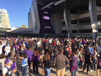
Sacramento Kings
Through a partnership with the National Basketball Association and the Sacramento Kings Professional Basketball team, the City built a new sports and entertainment venue in downtown Sacramento, the Golden 1 Center. To be efficient with space in the largely built out central business district, the Golden 1 Center does not include its own parking facility. Instead, the City has worked extensively with dozens of businesses which own parking facilities to develop special event parking agreements. The City and the King's goal is to develop a fleet of autonomous electric transit vehicles (AETVs) to provide shuttle service to and from many of these parking facilities which are not located within convenient walking distance from the Center. The City has initiated conversations regarding Connect The Grid 1.0, and the Kings concur that the deployment of connected infrastructure as part of this project is the critical first step in making AETVs a reality.
12. Leveraging Existing Advanced Transportation Technology Investments
Building on the Existing Network
Many building blocks exist as the foundation of Connect The Grid 1.0. Traffic signal controllers currently operate fixed timing plans throughout the central business district, but future enhancements through this project will enable signals to adapt to varying demands throughout the day, increase throughput, decrease delay, and communicate to vehicles through adaptive signal coordination and expanded signal interconnect. Existing vehicle detection is limited to in-pavement loops and cannot sufficiently provide data for enhancing signal operations. The City has installed closed-circuit television (CCTV) cameras at 98 locations and 10 new sites are being added on this project. CCTV cameras are deployed at critical locations throughout the City for traffic monitoring purposes. The City operates over 780 signalized intersections of which 430 have communications and are currently connected to central traffic control system. The City has installed 150 miles of conduit, two data centers, and over 100 miles of fiber optic cable. All of this is being leveraged as the foundation for Connect The Grid 1.0.
With this existing network in place, a physical architecture exists that can be cost-effectively enhanced into a robust network that accommodates the next generation of controllers, detection, cameras, and data.
Traffic Operations Center (TOC)
The City has implemented a sophisticated Traffic Operations Center (TOC), traffic communication network, and an Advanced Traffic Management System (ATMS) for centralized traffic control for optimizing the existing roadway system, manually changing signal timing, and managing incidents. The Traffic Operations Center is located in City Hall and utilizes a computer-based ATMS traffic signal control system which monitors traffic conditions and system performance. This system is a strong foundation for actively managing traffic conditions, but it is limited in its ability to utilize significant data points that are not sufficiently being collected today.
Sacramento Grid 3.0
Sacramento has initiated Grid 3.0, which outlines a roadmap for investing $200 million in downtown transportation improvements in a comprehensive fashion. This vision complements the Downtown Specific Plan, focusing on service enhancements for residents, employment, bicyclists, and pedestrians. A financing plan is in process and approval is expected by the end of the year. Through this effort, the City is exploring innovative new ideas in the use of the downtown transportation network (www.sacgrid.com).
Autonomous Transportation Open Standards (ATOS) Lab
ATOS recognizes that the city is the epicenter of an emerging innovation ecosystem with change agents working to develop breakthrough solutions that will accelerate quality of life improvements. According to their published vision (https://sacatos.org/), ATOS will accelerate mass market deployment and adoption of connected and autonomous vehicle technology by:
- Deploying the state's first 5G network that will power vehicle-to-vehicle (V2V), vehicle-to- infrastructure (V2I), and vehicle-to-pedestrian (V2X) communications.
- Leveraging proximity to regulators and shortening the feedback loop between policy and practice — enabling a smarter, faster regulatory approach.
- Co-developing an open source playbook to help other cities optimize their collaboration with public agencies and industry partners — allowing the "Sacramento Protocol" to replicate and scale.
Connect The Grid 1.0 has actively pursued partnerships with ATOS and has received a letter of partnering support.
Advanced Technology Testing
The City, in coordination with Sacramento County, is currently performing testing of several Bluetooth and Wi-Fi technologies at traffic signals for collecting travel time and origin- destination information. The City is also testing automated signal performance technology at several traffic signals to evaluate real-time functionality at signalized intersections. This allows traffic engineers to remotely measure real-time vehicle delay, volumes, speeds, and travel time of vehicles. These metrics will be used to identify operational deficiencies, optimize mobility, and help manage traffic signal timing and maintenance.
Integrated Corridor Management
Caltrans District 3 recently completed an Integrated Corridor Management (ICM) Implementation Plan (ICM) for US-50 in the Sacramento region. Caltrans selected this initial corridor to achieve performance improvements by enabling transportation system managers, transportation control systems, vehicles, and travelers within the corridor to operate in a collaborative fashion. With a stated objective of reducing congestion and improving mobility, the US-50 ICM project offers many benefits to the adjacent agencies and Caltrans through its numerous parallel arterials and existing communications infrastructure. The US-50 ICM includes a "Central City" segment in which W and X Streets are included. These facilities parallel US-50 and provide viable alternate routes to US-50. The City of Sacramento is a vital stakeholder in this ICM project and has been thoroughly engaged in the plan's development including the identification of these primary system routes.
Sacramento Region 511
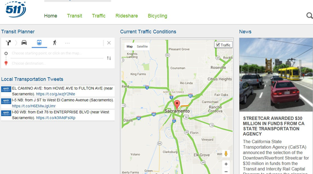
The Sacramento Region 511 provides information for all modes of travel in the six-county Sacramento area (El Dorado, Placer, Sacramento, Sutter, Yolo, and Yuba). Linkage is also provided to obtain transportation services information in Butte and Glenn Counties. Specifically, this system provides traffic conditions, public transportation information, and ridesharing information. Through its website (www.sacregion511.org) users can program daily commute patterns and monitor real time commute options proactively. In addition to serving the Sacramento region, dialing 511 also links users to similar 511 services in the San Francisco Bay Area, Nevada, and Oregon.
Smart Region Sacramento
SACOG is in the process of initiating a Regional ITS Architecture update, as well as Regional and Local ITS Technology Master and Implementation Plans, one of them being the City of Sacramento ITS Master Plan. SACOG has recognized that smart investments in transportation projects are needed to improve system performance, safety, sustainability, and reliability. Project objectives include smart technology strategies, smart region infrastructure, consistent and reliable system operations, improving system safety, improving traveler information, and disaster preparedness. Smart Region Sacramento encompasses the six-county SACOG Region and Caltrans District 3 facilities extending to the Lake Tahoe Basin.
Open Data Portal
As part of Sacramento's ongoing commitment to promote transparency, accountability, and citizen engagement, the Sacramento Open Data Portal was designed for the public to explore, visualize, and download the City's publicly accessible data. Developers can also use exported data to build new Web and mobile applications. Connect The Grid 1.0 will interface with the portal to enhance the transportation elements for a mutual benefit as there are data distribution standards in place and the portal is built to easily integrate new data sources. (http://data.cityofsacramento.org/)
Parkeon
Parkeon is an expert in improving urban mobility by providing a single platform encompassing parking management and ticketing solutions for parking and public transportation.
The City of Sacramento invested in its commitment to implement advanced technology to enhance the user experience by partnering with Parkeon to design the SacPark app. The app makes it easier to locate a parking spot, purchase parking in advance, provide information on space availability, and obtain real-time traffic information. The app is integrated into a public education campaign and an online navigation tool that highlights information on various transportation options when traveling to downtown and Golden 1 Center, including: light rail, ride share, and bicycles. This information will be available at Mobility Hubs strategically located in the downtown Grid.
Golden 1 Center Event Management Plan
The City developed an Event Management Plan for the downtown area that outlines strategies to provide safe, convenient, and efficient access for all travel modes to and from Golden 1 Center, the new home of the Sacramento Kings, located in the heart of downtown Sacramento. The identified strategies are intended to manage large influxes of vehicles, pedestrians, bicycles, and transit before, during, and after events at Golden 1 Center. The Plan is a living document that may be modified by the City as conditions change, and based on experience and input from additional parties, including the City of Sacramento, the Golden 1 Center operator, local transit agencies, and the public.
5-Bar
Sacramento has recently conducted its 5-Bar study to assess the feasibility of providing City- wide Wi-Fi service. Expanding access to city services to anyone, anytime, anywhere (responsive, accessible, and mobile) is a primary mission of the City's Digital Strategy.
Sacramento City 311
Sacramento City 311 is a centralized call center for the City of Sacramento that is intended to make life a little easier for its residents, businesses, and visitors. Sacramento City 311 call center works to assist the community 24 hours a day, seven days a week. 311 allows residents, businesses, and visitors to request service, report problems or get information from local government. They handle requests for building permits, stray animals, utilities services, and much more. 311 provides a single point of contact for City of Sacramento government services and is an important source of information for input into Connect The Grid 1.0.
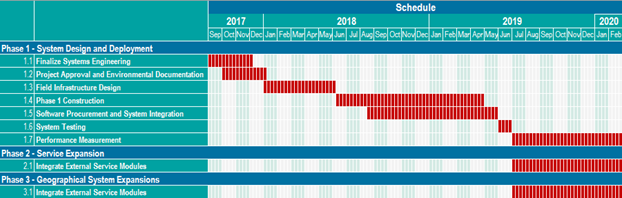
13. Deployment Schedule
The following schedule reflects an aggressive but realistic timeline for developing, designing, and implementing Connect The Grid 1.0. It starts with finalizing the System Engineering
Management Plan documents in compliance with FHWA 23 CFR 940. While FHWA concurrence is being obtained, the project will move into the design and construction phase. With an overlapping software and system integration project, system testing is anticipated in June 2019.
14. Support of ITS Initiatives
Connect The Grid 1.0 is a program that has several layers of technology, software, and integration that form an interwoven web of intelligent data networking. One critical component of that web is the installation of connected vehicle technologies. This program will leverage Connected Vehicle Initiatives and Pilot Deployment Programs currently in development as a springboard to aggressively deploy, operate, and evaluate intersection-based connected vehicle technology for pedestrians, bicycles, and vehicles. The clear benefits of installing V2I equipment at intersections for red light violation warning and pedestrian/bicycle intersection presence will build on existing pilot assessments, particularly New York City. Sacramento is prepared to immediately deploy connected vehicle equipment following our own pilot assessment using DSRC communications.
Other applications associated with Connect The Grid 1.0 include:
- Forward Collision Warning
- Transit Warning
- Vehicle Turning Right in Front of Bus
- Eco-Traffic Signal Timing
- Vehicle Classification-Based Traffic Studies
- Probe Enabled Traffic Monitoring
- Intelligent Traffic Signal System
- Transit Signal Priority
As Connect The Grid is advanced beyond 1.0, additional applications include the following:
- CV-enabled Turning Movement and Intersection Analysis
- CV-enabled Origin-Destination Studies
- Mobile Accessible Pedestrian Signal System
- Dynamic Transit Operations
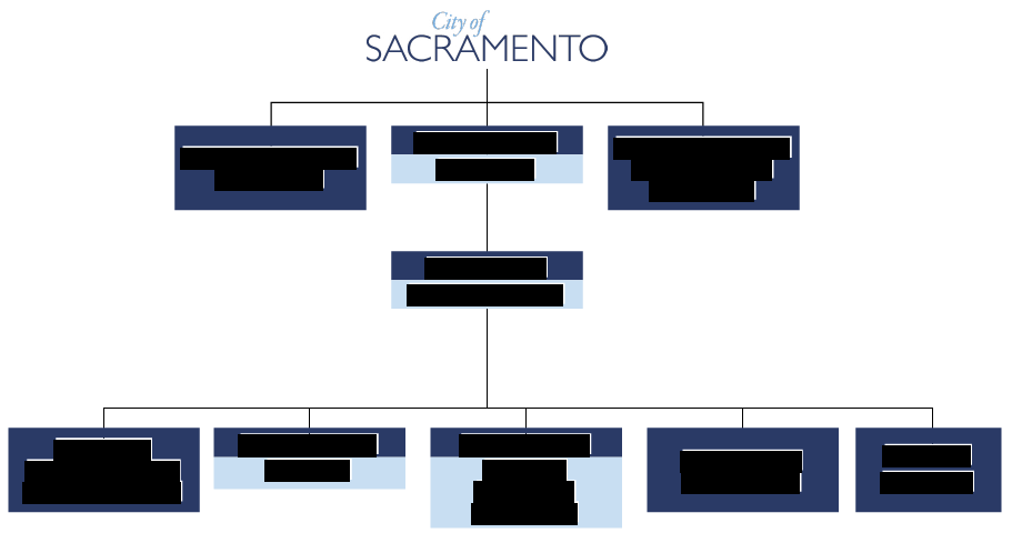
15. Staffing Description
As demonstrated on the organizational chart and within the resumes of our team members, Sacramento has
Redacted
Redacted