2017 Keep Oregon Trade Moving Advanced Transportation and Congestion Management Technologies Deployment (ATCMTD) Grant Application
a. Project Description
1. Introduction
Oregon is a state with diverse geography, and an economy that depends on an efficient transportation system that links the urban and rural regions of our state. Oregon exporters and importers face mounting logistics challenges due to the loss of weekly Portland Terminal 6 container service and changes in the international maritime and transportation industries. With the departure of Hanjin and Hapag-Lloyd container service at the Port of Portland's Terminal 6 in early 2015, thousands of Oregon businesses directly and indirectly experienced increasing challenges moving goods to and from global markets.
This proposed ATCMTD grant project includes specific solutions to improve the transport of goods in the range of urban and rural settings that characterize Oregon. Active traffic management, advanced traveler information systems, freight signal priority, variable speed limits, and other technologies will provide improved safety, efficiency, and travel time reliability to Oregon's businesses and citizens. The 2017 "Keep Oregon Trade Moving" project will show how advanced transportation technologies can help Oregon businesses that are facing increased transportation costs, longer transit times, reduced reliability, greater business risks, loss of markets and market share, and other challenges. This proposal builds on our previous 2016 grant proposal, while introducing two new projects that further the goals of the ATCMTD program.
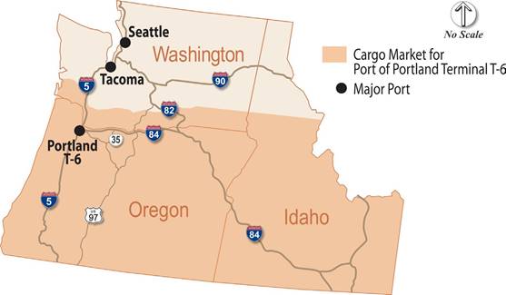
Figure 1: Cargo market for Port of Portland terminal 6
This proposed 2017 Keep Oregon Trade Moving ATCMTD grant project includes the following roadways:
- OR212 from I-205 to OR212/224 at Rock Creek
- OR224 from 99E to I-205
- Columbia Boulevard from Terminal 6 to I-205
- Cornelius Pass Road in Washington County
- US 97 between Bend and La Paine
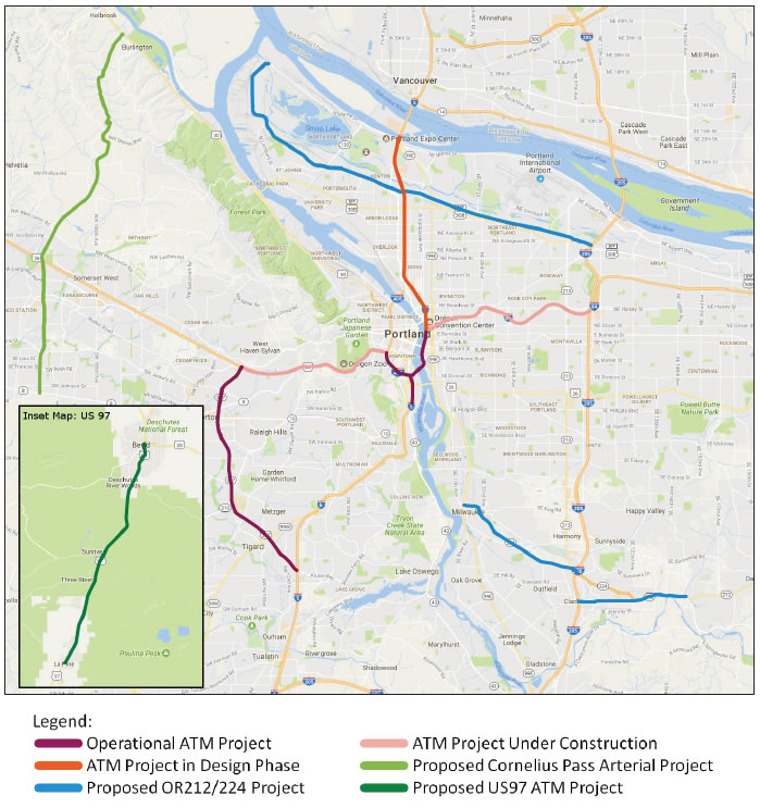
Figure 2: Existing and Proposed Advanced Transportation Projects in the ATCMTD Project Area
The regional economy in Western Oregon is based heavily on "traded industries" – activities that deliver products and services to customers outside the region. However, a range of urban and rural transportation challenges face Oregon's businesses, which the state must overcome in order to maintain economic competitiveness and ensure that our businesses continue to provide a good quality of life for our citizens. In the urban area around Portland, increasing congestion and the cessation of container service at Port of Portland Terminal 6 have made it more difficult for regional producers to get their products out of the city, particularly towards the export terminals in Seattle. Cornelius Pass Road, which serves both rural areas and as an alternate freight route for technology companies in Oregon's "Silicon Forest," suffers from long travel time delays during peak conditions, and slow emergency response times, as well as difficult access in wintry, icy conditions. US 97 provides a critical freight link along the rural corridor from Bend in Central Oregon southwards to Klamath Falls and into California, but is also subject to dangerous weather conditions, particularly in winter. The Keep Oregon Trade Moving project will significantly contribute to the region's and the country's economic competitiveness by demonstrating how the range of CV applications can improve system performance and safety in urban and rural settings, and generate economic benefits for citizens.
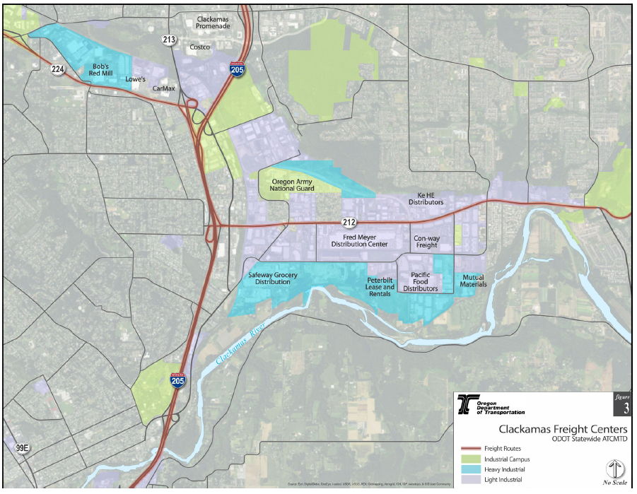
Figure 3 illustrates the key freight distribution centers along OR212/224 that will benefit from this project because of increased transit travel time reliability.
Smarter Cities
The 2017 Keep Oregon Trade Moving grant project facilitates the movement of goods and people along the corridor using freight and transit signal priority at intersections along key corridors, as well as Automated Traffic Signal Performance Measures (ATSPMs) that enable monitoring and reporting against outcomes related to equity, safety, congestion, access, and mobility.
Proposed Technology Deployments
The ATCMTD program presents an opportunity to leverage the capabilities of Oregon DOT's extensive active traffic management platform and extend its reach and capabilities by incorporating new mobile data sources, in-vehicle information dissemination, vehicle-to infrastructure communication, and cloud-based analytics. The result will be more accurate, reliable, and accessible traveler information to shippers, allowing them to make smarter routing decisions, improve freight travel time reliability, and increase safety for all road users on the corridor.
Public and private partnerships are critical to achieving the Keep Oregon Trade Moving vision of providing ubiquitous and actionable traveler information. ODOT will partner with City of Portland, TriMet, and Washington County to deploy signal upgrades, transit and freight signal priority, traffic signal performance measures, and ATM systems. Additionally, through the TripCheck Traveler Information Portal (TTIP), ODOT will offer expanded traveler information both directly to the public, as well as to third-party private companies such as Here, Waze, and Google Maps. Lastly, ODOT continues to partner with outside companies such as Intel and Jaguar Land Rover to explore additional opportunities for disseminating traveler information.
To support efficient goods movement, the following strategies are included with the proposed Keep Oregon Trade Moving project:
Arterial Corridor Management on Columbia Boulevard (from Port of Portland Terminal 6 to I-205) and OR212/224 from 99E to Rock Creek (at the OR212/224 intersection)
Advanced signal performance measurement capabilities, enabled enhanced detection, network communications, and central signal system connectivity, will provide signal operators better insight into arterial conditions and tools to conduct more proactive corridor management. The integration of V2I dedicated short range communication (DSRC) systems on Daimler and TriMet fleet vehicles and the arterial signal system will further extend these corridor management capabilities. Equipped vehicles will be able to take advantage of advanced connected vehicle freight and transit signal priority capabilities, enabling safer and more efficient progression of truck and bus traffic through key freight corridors.
The goals of improved travel time reliability and reduced crashes will be achieved using these arterial operations strategies:
- Equip Daimler and TriMet fleet vehicles with DSRC onboard units to enable V2I communication with arterial signals
- Instrument Columbia Boulevard from Terminal 6 to I-205 (16 traffic signals) and OR212/224 (16 traffic signals) with DSRC roadside units to support V2I communication with equipped freight and transit vehicles
- Implement DSRC-based freight and transit signal priority applications and signal phase and timing (SPaT) data dissemination capabilities on equipped arterial intersections
- Implement a next generation, software-based transit signal priority request system for TriMet buses, install software on TriMet's existing bus fleet, and develop a priority request server that could be hosted in the cloud or on premise
- Implement Automated Traffic Signal Performance Measures (32 traffic signals)
Cornelius Pass Road CV & ATMS Rural-Urban Arterial Project
Rural and Urban Arterial Connected Vehicle (CV) and Advanced Transportation Management Systems (ATMS) will be showcased along the major trade route of Cornelius Pass Road, running nearly 12 miles through suburban and rural landscape, directly adjacent to Intel's campuses.
Cornelius Pass Road is the key north-south trade route connects major three major east-west ODOT freeways (OR 8, US 26, US 30). Cornelius Pass Road acts in an integrated corridor manner with US 26, as the diversion route from the high-tech Washington County (Intel, Nike world headquarters) to downtown Portland and all Portland trade hubs (Port of Portland, Portland International Airport).
The addition of CV and ATMS treatments will enhance the safety, reliability, and optimization of system efficiency along Cornelius Pass Road by the following proposed project treatments:
- Implement rural ATMS safety system, with dynamic curve warning, active weather sensors, and cameras, connecting via ODOT's Real Time Software to new arterial Variable Message Signs (VMS) & direct to on-board telematics with Washington County-based Traffic Technology SolutionsTM (TTS) and Portland-based Jaguar Land RoverTM (JLR) incubator partners.
- Instrument corridor for CV Signal Phase and Timing (SPaT) secure message transmission through Washington County-based private partner Intel's secure internet of things (IoT) gateway, via dedicated short range communications (DSRC) & Center to Vehicle via partnership with Oregon-based Traffic Technology SolutionsTM (20 traffic signals).
- Implement automated traffic signal performance measures to actively manage & optimize (ATSPM, 21 traffic signals), including pedestrian-bicycle active measurement using Washington County's Eco-CounterTM Performance Management sensors (3 arterial stations)
- Deploy and enhance Washington County's red light running crash mitigation system in partnership with WavetronixTM and IntelightTM (6 traffic signals) to enhance safety for all vehicles, not just Connected Vehicles.
- Activate truck signal priority to enhance freight reliability and safety via DSRC in Intelight's MaxConnectTM and WavetronixTM to keep Oregon Trade Moving (6 traffic signals).
US97 Weather-Responsive Variable Speed System
The US 97: Bend to Spring Creek Hill is a weather responsive variable speed system on US 97 from MP to 143 to 244. The project is divided into three distinct segments based on weather severity, traffic volumes and crash data. The segments are:
- Bend to La Pine (Priority #1), MP 143 to 164
- La Pine to Chemult (Priority #3) MP 164 to 204
- Chemult to Spring Creek Hill (Priority #2) MP 204 to 244
The project will install road and weather information system (RWIS), speed sensors, Bluetooth travel time readers, changeable message signs. Variable speed limits have shown a decrease in winter weather related crashes of up to 50% on I-80 in Wyoming. In addition to the safety benefits, a variable speed system will provide secondary benefits:
- Real-time data from additional RWIS station will support maintenance crew decision regarding snow and ice control measures, which will improve resource allocation efficiency.
- Speed sensors will collect traffic count and speed data throughout the corridor that will support performance measurement outlined in TRIP 97 and ODOT's TSMO Performance Measurement Plan.
- Additional traveler information will be provided to ODOT's existing TripCheck system to support informed traveler decisions.
Additionally, roadside locations could be equipped to communicate road and weather and safe speed conditions to freight vehicles via V2I.
2. Entity that will enter into the agreement
This section includes a description of the entity proposed and how Oregon DOT will manage the program.
2a. Entity proposed
The Keep Oregon Trade Moving project will be executed as an infrastructure project by the Oregon Department of Transportation, and includes key partnerships with outside public and private entities. Oregon DOT will be responsible for the agreement with FHWA and the overall project delivery. Galen McGill, Oregon DOT's ITS Team Manager, will serve as overall project manager and liaison to U.S. DOT, as well as oversee the technical aspects of the project. Andrew Dick, Oregon DOT's Connected, Automated, and Electric Vehicle Advisor, will assist Galen in overseeing the project. Several other sections within Oregon DOT will also be involved with various aspects of the project.
2b. How Oregon DOT will manage the program
The Oregon Department of Transportation is accustomed to delivering transportation infrastructure and ITS projects, including projects funded in part by the federal government, and will use its usual process for design, procurement, and delivery phases of the project. The project will have an overall steering team to make executive decisions, consisting of Galen McGill, Andrew Dick, Joel McCarroll, Stacy Shetler, and Peter Koonce. Galen McGill, ITS Team Manager, will act as Project Director as well as being the lead on delivery of ITS applications deployed in conjunction with the project. Andrew Dick, Oregon DOT's Connected, Automated, and Electric Vehicle Advisor, will be Deputy Project Director and assist Galen and the rest of the team in executing the project. Peter Koonce will represent the Portland Bureau of Transportation for the Columbia Boulevard project, while Joel McCarroll with Oregon DOT's Region 4 will oversee the project along US 97. Doug Spencer will serve as Standards Engineer and handle contracts with consultants, equipment suppliers and technology vendors. Additional information on project staffing and an organizational chart are included in Section b1, on page 24, "Description of Organization Staffing."
The deployment of new infrastructure will follow a similar process to Oregon DOT's existing TIGER grant project with U.S. DOT and Washington County to deploy Active Traffic Management in the Portland area. Initially, Oregon DOT will work with a consultant to design the project to install new infrastructure, using a consultant project manager within Oregon DOT to manage the design phase. Once the project design is complete, Oregon DOT will conduct a bidding process for the construction work related to the project. Ron Larson will act as Oregon DOT's Construction Project Manager for the initiative and oversee the construction of roadside equipment or other devices completed by a contractor. This is consistent with the usual process Oregon DOT uses to deploy ITS and ATM solutions on our highways.
The ATCMTD program will also involve the deployment of new software applications, which will involve the Transportation Application Development (TAD) section within Oregon DOT's information services department. Oregon DOT will design requirements for new software systems associated with the ATCMTD program either in-house or by working with a consultant, then conduct a procurement process to acquire and implement the new system. The TAD section will be responsible for implementing the new software system following procurement, which can involve a significant degree of customization to ensure compatibility with the existing system. Oregon DOT and the City of Portland have committed to providing local matching funds for this project. Both the Oregon DOT and City of Portland oversee millions of dollars in federal funding on a regular basis and they also regularly hire a third party certified public accountant to audit their spending of federal money. In addition to traditional federal funding sources, both agencies have secured and successfully overseen the use of previous TIGER grants and federal American Recovery and Reinvestment Act (ARRA) funding.
3. Geographic area the deployment will service
The project area includes Columbia Boulevard and OR212/OR224 in the Portland area, as well as Cornelius Pass Road in Washington County. The portion of US 97 from Bend to La Pine is geographically removed from the other project elements, but shares the characteristic of being a critical freight route where travel time reliability and safety can be increased through advanced transportation technology deployment. This diverse set of applications will also allow the project to demonstrate how CV technologies can be deployed across a range of geographies, from urban to suburban to rural settings, to provide economic and safety benefits to road users. The project corridors are illustrated in Figure 5.
| Corridor | Extents | Description |
|---|---|---|
| OR212 | I-205 to OR212/224 (Rock Creek) |
|
| OR224 | OR99E to I-205 | |
| Columbia Boulevard | Port of Portland Terminal 6 to I-205 | |
| Cornelius Pass Road | OR8 to US30 |
|
| US97 | Bend to La Pine |
|
Figure 4: Project corridors description
4. Real world issues and challenges
Oregon's economy depends on the ability of our businesses to stay competitive in the global marketplace. Oregon exporters and importers face mounting logistics challenges due to the loss of weekly Portland Terminal 6 container service and changes in the international maritime and transportation industries.
In April 2015, Governor Kate Brown launched the Trade and Logistics Initiative to work with small and medium-sized business across Oregon to help identify solutions to their trade-related freight logistics challenges. Our collective agency team engaged more than 300 people in community forums held in Albany, Grand Ronde, Hermiston, Medford, Ontario, Portland, Redmond, and Wilsonville and consulted with freight experts to develop recommendations for action and implementation. These recommendations fall into four categories:
- Resolution of Terminal 6 labor-management issues and restoration of weekly container service
- Operational enhancements and actions to improve the existing logistics system
- Strategic investments in freight logistics to sustain services
- Policy actions to enhance Oregon trade and improve the transport of goods
The proposed strategies in this grant are the result of the planning effort and outcome from the Governor's Trade and Logistics Initiative. This project addresses operational enhancements and proposes actions to improve the transportation and movement of goods. The proposed actions and strategies in this grant are intended to help Oregon businesses that are facing increased transportation costs, longer transit times, reduced reliability, greater business risks, loss of markets and market share, and other business impacts. A description of the real world issues is included below.
Freight-Specific Mobility Issues on Columbia Boulevard and OR212/224
The traffic signals throughout the Columbia Boulevard and OR212/224 corridors are neither interconnected nor timed for the heavy concentration of truck activity that comprise a growing portion of traffic on these corridors. Additionally, individual performance characteristics and limitations of freight vehicles (e.g., varying stopping distances and acceleration capabilities) cannot be accounted for in current signal operation systems. As a result, travel into and through the corridor can be unpredictable, affecting the many companies that depend upon transportation delivery certainty as part of their business model. Keep Oregon Trade Moving addresses these issues by deploying advanced communications technologies and system operations techniques that dynamically incorporate the unique performance characteristics of freight vehicles and enable safer and more efficient progression of truck traffic through the corridor.
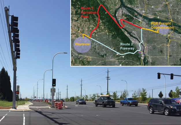
Safety & Reliability Issues on Cornelius Pass Road Arterial
Cornelius Pass Road is the primary alternate route from Highway US 26 to/from downtown Portland, Portland International Airport/Port of Portland, and the westside High-Tech "Silicon Forest," home to project partner Intel's world headquarters, Nike world headquarters. During congested peak periods, very high value freight diverts to Cornelius Pass Road, which is a two-lane rural roadway, with steep grades and curves in project partner, Multnomah County's section, creating safety hazards for all vehicles.
The ATMS active curve warning system, weather alert system, and red light running crash mitigation systems proposed will increase the safety and reliability of this important trade route to Keep Oregon Trade Moving. Linking the Cornelius Pass Road network and ATMS system into ODOT's ATMS system will allow for a common platform for integrated corridor management of the primary US 26 route and the diversion Cornelius Pass Road route. Demonstration of broadcast SPaT and weather alerts direct to vehicles will enhance reliability and safety by better informing motorist of conditions along the congested signalized portion of the corridor, and the curvy, hilly section in rural Multnomah County, where emergency response is difficult and environmental impact risks are greater for off-the-road incidents.
Along the proposed Cornelius Pass Road corridor:
- Peak hour travel times can be over 60% longer than free flow conditions along the arterial, but it is typically 25 minutes1 faster via Cornelius Pass Road arterial to PDX freight consolidation area than the congested primary US 26 freeway route, even though it is more than 3 miles longer out-of-direction. Congestion can be reduced by the proposed Connected Vehicle treatments.
- Weekday PM peak travel time reliability is 6 times more reliable than the primary US 26 route to downtown Portland and PDX airport. Increasing reliability for both routes can be realized with this Keep Oregon Trade Moving ATCMTD Project.
- 47 fatal or serious injury crashes tallied in on Cornelius Pass Road (11 in Washington County, 36 in Multnomah County) in the past 5 years (2012-2016). Active curve warning, weather alert systems, and red light running crash mitigation systems will reduce crash exposure and severity.
- Emergency response times are often exceed 20 minutes, the Portland Metro Area incident response goal. This is due to the rural, single-lane per direction roadway, very limited alternate routes outside of US 26 for Cornelius Pass Road in Multnomah County. When there is a major crash, the entire route is often closed completely and emergency access can be difficult, particularly in winter, icy conditions.
The Keep Oregon Trade Moving Connected Vehicle and ATMS Arterial Demonstration will provide a strong return on investment towards enhancing travel time reliability, reducing congestion, and improving safety.
US97 Real-World Issues and Challenges
US 97 carries the fourth highest volumes of freight in the state.
The corridor ranges in volume from 15,000 to 4,000 AADT with truck percentages ranging from 11% to approximately 40%.
The corridor is subjected to severe winter weather and changing conditions and microclimates. Over half of all the crashes occur when the road is impacted by snow and ice.
Additionally the corridor serves many drivers who are unfamiliar with operating in snow and ice conditions. Central Oregon is a winter recreation destination for people from the Willamette Valley area in Oregon, the Puget Sound area in Washington and Northern California. All of these areas have much less severe weather than the Central Oregon in the winter. Road and weather information and information about safe operating speeds will be helpful in improving safety in the corridor.
Additionally the corridor has few alternate routes and little in the way of motorist services between the communities along the route. This mean during a severe incident there are relatively few effective detours and methods of providing information to motorists.
Addressing ATCMTD Goals
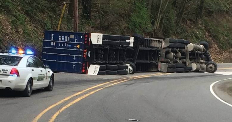
Overturned semi truck on NW Cornelius Pass Road, 3-4-2016
In support of the DOT's vision to deploy advanced technologies and strategies to address issues and challenges in safety, mobility, sustainability, and economic vitality, the ATCMTD initiative has established 11 overarching goals to be addressed by the proposed deployments. Keep Oregon Trade Moving provides technologies and solutions that deliver on all of these goals.
| ATCMTD Program Goals | Keep Oregon Trade Moving Capabilities |
|---|---|
| 1. Reduced costs through enhanced use of existing transportation capacity | The Keep Oregon Trade Moving project uses technology and optimized system management approaches to reduce crashes and improve freight, transit and general purpose traffic mobility. |
| 2. Delivery of environmental benefits | A byproduct of improved management of the transportation network and enhanced traveler information is reduced vehicle idling, smoother traffic flows, and fewer incidents — all outcomes that result in reduced fuel use and greenhouse gas emissions. |
| 3. Measurement and improvement of the operational performance of the transportation network | Keep Oregon Trade Moving incorporates various elements that improve the ability of system managers to measure and optimize operational performance, high-detail traffic signal performance data, regional ATM system enhancements, and TripCheck Travel Information Portal (TTIP) enhancements. |
| 4. Reduced crashes and improved traveler safety | Keep Oregon Trade Moving proposes proven ATM approaches that have consistently demonstrated crash reduction and safety benefits. The OR 217 ATM implementation for example reduced crashes by 21%. |
| 5. Use of real-time transportation information to improve mobility and improve access to key services | Enhanced data collection from fixed and mobile data collectors is a main component of each project corridor. The incorporation of this data into operational improvements, however, is where the project adds the greatest value. Keep Oregon Trade Moving employs real-time data in a variety of ways to improve mobility and the efficiency and accessibility of the transportation network, including freeway speed harmonization, queue detection and warnings, en route travel times and traveler information, freight and transit signal priority, and pre-trip traveler information enhancements via the TTIP system. |
| 6. Monitoring transportation assets to improve infrastructure management and ensure state of good repair | The ATM system proposed by Keep Oregon Trade Moving supports asset management by providing alerts when field equipment may require maintenance, thereby ensuring improved system uptime and overall state of good repair. |
| 7. Delivery of economic benefits associated with improved system performance and efficient movement of people, goods, and services | Keep Oregon Trade Moving was developed in recognition of the economic challenges faced by the region from increased transportation costs, longer transit times, reduced reliability, greater business risks, and loss of markets and market share. The project addresses these challenges directly and improves the economic competitiveness of the region through the strategic deployment of advanced technologies on highly-trafficked freeways. |
| 8. Accelerated deployment of V2I and automated vehicle applications | Connected vehicle technologies and applications are critical components to the Keep Oregon Trade Moving vision. V2I communication between freight vehicles and traffic signals are what enable the kind of dynamic and freight traffic-optimized strategies the project envisions. Additionally, and uniquely to this region, the project is able to leverage the established and tested regional automated ATM platform to generate and deliver target speed recommendations, queue warnings, and traveler information to connected vehicle fleets. Such an established back-end allows our region to advance and expand connected vehicle applications more readily. |
| 9. Integration of advanced technologies in transportation system management and operations | Keep Oregon Trade Moving supports and advances the region's long-running commitment to incorporating leading-edge TSMO technologies in its practices. One key example is the integration of mobile vehicle-based weather data to complement and enhance the capabilities of the region's road weather management system. |
| 10. Quantifying and evaluating safety, efficiency, and sustainability impacts | Keep Oregon Trade Moving delivers detailed system performance measures for ongoing performance monitoring. The project provides traffic signal performance measures, automated speed, travel time and volume data that is made available to the public through Oregon DOT's TripCheck website. |
| 11. Reproducible systems and services to support deployment in other locations | Keep Oregon Trade Moving proposes concepts that are reproducible and extend the functionality of existing, well-tested systems and platforms. Proposed mobile road weather data collection systems can be equipped to fleet vehicles in any location, freight signal priority strategies can be reproduced in any arterial environment using standard ATC-based signal system components, and freeway ATM approaches follow FHWA best practices and Oregon DOT's regional ATM strategic plans. |
5. Transportation systems and services included in this project
Oregon DOT Real Time ATM projects in Oregon
Many different solutions will be used in the Keep Oregon Trade Moving project as described in this section.
OR224 (from OR99E to I-205), OR212 (from I-205 to OR212/224), and Columbia Boulevard (from Port of Portland Terminal 6 to I-205)
Implement arterial operations strategies to improve travel time reliability and reduce crashes including the following:
- Travel time – Oregon DOT's travel time system estimates expected arrival time to major destinations using real-time traffic conditions.
- DSRC transit signal priority – When a bus nears an intersection, a green indication can be displayed sooner or can be extended depending on the estimated arrival time. Transit signal priority will be implemented using DSRC.
- DSRC truck signal priority – Similar to transit signal priority, truck signal priority will be provided to trucks by displaying a green indication sooner or extending a current green phase. DSRC-enhanced Freight Signal Priority (FSP) using V2I communications between equipped freight vehicles and signals will enable advanced FSP approaches that support safer and more efficient freight traffic movement. By incorporating dynamic characteristics of equipped trucks (including vehicle speed, weight, length, and acceleration characteristics), signal systems can provide variable green time extension, yellow change intervals, and dilemma zone protection that is optimized for the performance characteristics of the freight traffic in the corridor. Reduces unnecessary delays and stops and enables safer, more efficient flow of freight on the corridor
- Next Generation Transit Signal Priority (TSP) – a software based priority request system which provides more functionality than Infrared TSP, but preserves existing investments in TSP. Next Generation TSP will work in parallel with the existing Infrared TSP and new installations of DSRC-based TSP. Next generation TSP provides:
- Relative priority: – vehicle type, response type, service type, agency type, time of day, bus occupancy, bus lateness, etc.)
- Turn-signal-dependent mode – supports left turn activation and queue jumps • Corridor coordination – bridging multiple intersections
- Time plans – vary system operation by time of day or day of week
- Extensive metrics to measure system performance and health
- Upgraded communications system – Reliable communications between field devices such as signs and traveler information as well as communications back to operations centers are imperative. Along many of the arterial project corridors, communications will be upgraded and the traffic signals added to the existing shared regional central traffic signal system.
- CCTV cameras – All of the arterial corridors will be outfitted with CCTV cameras at key locations to allow remote network monitoring from the City of Portland and Oregon DOT traffic operations centers. Camera images will also be provided to the public through Oregon DOT's award-winning TripCheck traveler information system.
- Traffic signal controller upgrades – This project will replace the traffic signal controllers that have not yet been upgraded to the latest advanced transportation controller standard that will support signal performance measures, providing system managers information about real-time and historical functionality at signalized intersections and a capability to identify operational deficiencies, optimize mobility, and better manage traffic signal timing and maintenance.
- Signal phase and timing – Implement traffic signal Connected Vehicle (CV) data including signal phase and timing on Columbia Boulevard (16 signalized intersections) and OR212/224 (16 signalized intersections).
Cornelius Pass Arterial CV & ATMS Treatments
- Multimodal integrated corridor management – ICM systems including real-time weather alert system, roadside travel time system, truck signal priority, active rural curve warning, traffic signal performance measures with ATC Linux next generation traffic signal controllers, roadside variable message signs, and CCTV cameras for enhanced information sharing, and Connected Vehicle "over the air" systems to alert and inform the arterial and freeway users.
- CV technologies at intersections and pedestrian crossings – DSRC installation at West Union/Cornelius Pass for truck signal priority comparison to legacy radar-loop systems, fiber optic networking and ATC Linux traffic signal controllers to facilitate SPaT, BSM, and other CV data streams, Smart Red Light Running Crash Mitigation System using radar and ATC controller to adapt signal timing to predicted red light runners and reduce crash exposure/rates, and Vehicle to Infrastructure Travel Time Systems using Bluetooth and WiFi.
- Technologies supporting connected communities – DSRC & cellular to broadcast SPaT and Basic Safety Message (BSM) data to/from OEMs.
- Infrastructure maintenance, monitoring, and condition assessment – Fiber network expansion for remote monitoring and alert system via cameras, central signal management software, and Bluetooth travel time system. ATC signal system and implementation of Utah DOT-style Automated Traffic Signal Performance Measures System. Emergency management battery backup system to keep traffic signals and ITS equipment operational during power outage on key arterial route. Weather tracking and performance system, curve warning system, and arterial VMS system to post travel times and conditional alerts.
- Rural technology deployments – Rural integrated camera, weather station, and travel time system. Rural arterial VMS system to post travel times/conditional alerts and rural curve warning system for Cornelius Pass Road over West Hills.
The Keep Oregon Trade Moving project will contain enhanced network solutions, including resource sharing between the Counties, ODOT, and the City of Portland, via shared software platforms and over 50 years of regional collaboration as the bedrock for "moving at the speed of trust" to accomplish more in this USDOT ATCMTD demonstration of unique treatments at a strong return on investment.
The Portland region shares:
- ODOT's tested and established Advanced Transportation Management (ATM) system software, RealTimeTM, which will act as the enterprise management system and interface for travel time systems, queue warning, curve warning, weather alert, and variable speed limit systems.
- a single legacy traffic signal central management software & a single statewide ATC controller software and DSRC/CV system software already procured and ready to go,
- shared regional data (Portland State's PORTAL) archive that's been an asset for over 10 years,
- shared traveler information platform (ODOT's tripcheck), and
- shared data portal to distribute data widely to private industry and media (ODOT's TripCheck Traveler Information Portal or TTIP).
Combine this with established, pre-existing partnerships with international leaders in private tech and transportation industry to accelerate implementation and provide second to none system insights to overcome integration issues that occur with leading edge technology demonstration projects. The project will include public-private collaboration throughout the systems engineering, design, implementation, and testing phases of the project.
US97 Systems and Services
Grip factor sensors: These sensors measure the level of grip of the roadway surface, or grip factor. The grip factor is greatly impacted by rain, snow, and ice. These are proposed for installation at every other variable speed sign location.
Road weather information systems (RWISs): RWIS stations support detection of adverse weather or roadway conditions through measurement of roadway surface classification and visibility. Additional weather variables collected by RWIS stations such as air temperature and rainfall intensity may also be measured for evaluation and fine-tuning of the system.
Automatic Traffic Recorders (ATRs): Existing ATRs on US 97 will collect volume and vehicle classification data to support performance measurement of the variable speed system.
Variable speed (VS) signs: VS signs will be used at the entry point of each speed zone, at regular intervals, downstream of major entry points, and at locations where the maximum posted speed changes based on speed zone orders. The sign legend will be the black on white regulatory basic rules peed sign (OR2-1). Either the entire sign will be comprised of LEDs or a static sign will be used with an LED insert for the speed and historical functionality at signalized intersections and a capability to identify operational deficiencies, optimize mobility, and better manage traffic signal timing and maintenance.
Speed sensors: These will measure real-time speed to support the procedures outlined in the concept of operations for determining variable speeds. Speed sensors are proposed for installation in conjunction with every variable speed sign.
Variable message signs (VMSs): These will be used to notify drivers of adverse weather conditions or advance notification that variable speeds have been enacted.
Supplementary signs: Similar to standard speed zone notification signs, advance signs are needed to alert drivers they are entering a variable speed zone corridor. These may be static signs or VMSs may be used to provide this information.
Closed-circuit television (CCTV) cameras: These will be used to monitor system operations and support decisions related to manual system overrides.
TripCheck system: The posted speed will likely be provided in real-time to ODOT's existing TripCheck system, which provides traveler information through a variety of means (e.g. website, 511, social media, public access message broker). This effort will be addressed at the statewide level by the ODOT ITS Unit.
6. Plan for long-term operation and maintenance
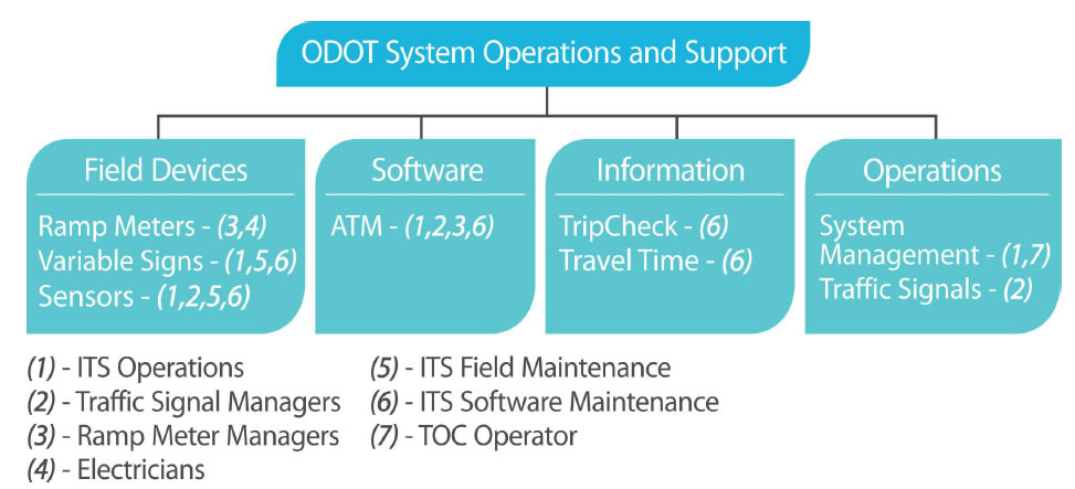
Figure 5: Oregon DOT system operations and support
The equipment installed as part of the ATCMTD program will be operated and maintained along with the rest of Oregon's ITS and traffic signal infrastructure. Oregon DOT operates a network of field devices and software systems that enable active traffic management on corridors around Portland, including a web portal that allows public users or third party software developers to access congestion and weather alert information generated by the Oregon DOT system. Figure 7 shows several systems operation and support categories related to Oregon DOT's ITS network. Oregon DOT operates a variety of field devices for its ITS infrastructure, including ramp meters, sensors, variable advisory signs, and dynamic message signs. Different teams within Oregon DOT are responsible for different functions related to these devices. ITS system operators, including Dennis Mitchell and Michael Burkhart, develop the framework that governs the operation of the system, the times of day when the system is active, which sensors are used to trigger different features, and so forth. ITS system operators adjust the software that underlies ATM applications, and make changes to system management in real time, in response to roadway conditions. ITS system operators will also be responsible for operating the new applications deployed under the ATCMTD program.
Signal managers operate the network of traffic signals, including changing timing on signals or implementing applications that affect signal phase and timing. For the elements of the ATCMTD program that involve upgrading existing signal infrastructure and adding CV technology to signals, including radios and software to support truck signal priority, signal managers will make adjustments related to these functions. Ramp meter managers make adjustments to ramp meter rates as part of the ATM system, adjusting influx of vehicles in order to avoid downstream bottlenecks in response to traffic conditions.
Oregon DOT's ITS maintenance team maintains the technology equipment, such as dynamic message signs, weather sensors, camera equipment, and communications to field devices. This team of specialists makes repairs to field equipment and works with Oregon DOT electrical crews for work where journeyman licensing is required.
Oregon DOT's ITS Central Systems team is responsible for 24x7 support of all ITS software, servers and network infrastructure. Any systems deployed as part of the ATCMTD program will be supported by these existing resources.
Lastly, the Transportation Management and Operations Center (TMOC) operators coordinate the agency's instant response to roadway conditions. TMOC can detect congestion, dispatch incident response to the site of a collision, or notify ITS maintenance of malfunctioning infrastructure in need of repair. TMOC will perform these same functions for new infrastructure deployed under the ATCMTD program.
7. Challenges in regulatory, legislative, or institutional environments
The proposed strategies in this project build on the existing transportation system management and operations systems deployed in Oregon by adding a connected vehicle component. Examples of the system components this project will deploy that Oregon DOT is operating and maintaining in other corridors include:
- Award winning, fully automated ATM
- Traffic signal systems and signal performance measures
- Transit and truck signal priority
- Traveler information
- Data stores with access for the private sector in standard data formats
No regulatory or legislative challenges are anticipated with this project. Institutionally, Oregon DOT and the City of Portland already share a traffic signal system, access to video, a regional communications network, a regional data warehouse, and travel time systems. The Oregon DOT is currently partnering with the Port of Portland to refine the solutions identified with the Oregon Trade Solutions report. No institutional challenges are anticipated with this project.
8. Quantifiable system performance improvements
The Keep Oregon Trade Moving Project improves the existing transportation infrastructure using active traffic management, arterial management, connected vehicles, smarter cities, and multimodal systems. It reduces crashes, makes travel times more reliable, and protects the region's investment in the existing transportation infrastructure. The following bullet items represent the quantifiable system performance improvements that will create a regional transportation system that is resilient and reliable:

OR217 ATM project benefits
- Improve travel time reliability and reduce crashes using fully automated active traffic management that responds to weather and congestion
- Improve travel time reliability and reduce crashes on the arterial roadway system
- Improve mobility of commuters and freight
- Improve the multimodal system
- Promote the interface to connected vehicles
9. Quantifiable safety, mobility, and environmental benefit projections
The projects proposed for the 2017 Keep Oregon Trade Moving project include ATM systems on Cornelius Pass Road and US97, as well as Arterial Corridor Management projects that include transit and freight signal priority on Cornelius Pass Road and OR212/OR224. The potential benefits from these investments can be calculated using Oregon DOT estimates of the value of travel time and crashes, shown in Tables 1 and 2 below.
| $ Value of a Person Hour (per hour) "On-the-Clock" Auto | 30.55 |
| $ Value of Person Hour (per hour) Other Auto | 25.78 |
| $ Value of Vehicle Hour (per hour) Truck | 31.32 |
| $ Value of Fatality Crash | 1,582,500 |
| $ Value of Injury Crash | 75,250 |
| $ Value of Vehicle Hour (per hour) Truck | 19,400 |
Note: Average values shown. See HSIP report Table 3-1 for values by roadway type and urban/ rural classification.
ODOT analysis of previous ATM deployment show up to 21% reduction in crashes following deployment of ATM systems. Based on rural Oregon crash rates2 and annual VMT of approximately 100 million miles along the affected US97 corridor, this same level of reduction in vehicle crashes could provide an average benefit of $694,000 in reduced fatal and serious injury crashes along the corridor. Crash statistics from Washington and Multnomah County show a total of 47 fatal or serious injury crashes along Cornelius Pass Road over the past 5 years. A 21% reduction in fatal or serious injury crashes along this corridor would produce an annual benefit of $1.2 million in reduced fatal and serious injury crashes along Cornelius Pass Road.
A study by Portland State University3 investigated the potential benefits of freight signal priority along Columbia Boulevard, and found that the deployment of this application would improve overall travel delay by 13% and stop delay by 20% for truck traffic, as well as reducing hard stops of heavy vehicles by 9% to 16%, with associated greenhouse gas and pavement damage reduction benefits. While the DSRC freight signal priority application installed in conjunction with the proposed program would only affect approximately two dozen vehicles and initial benefits would be small, these findings illustrate the significant benefits that signal priority applications could achieve at scale deployment.
The proposed ATCMTD program would also implement Automated Traffic Signal Performance Measures (ATSPMs), as a cost-effective approach to improving signal performance along the Cornelius Pass, Columbia Boulevard, and OR212/OR224 corridors. These systems have been promoted by Federal Highway Administration due to the significant analysis and performance improvements they provide over conventional signal retiming practices.4 High-resolution data-logging from these units will provide data on metrics such as approach volumes, arrivals on red, transit and freight signal priority requests and services, and other measures of system performance that will allow for detailed documentation of project benefits following deployment.
10. Vision, goals and objectives
The proposed project will be guided by the following vision, goals and objectives.
Vision statement
The Oregon DOT will collaborate and proactively manage its multimodal transportation system to ensure safe, reliable, efficient, and equitable mobility for people and goods. The Portland region and the Oregon DOT will strive to be a nationally recognized leader for innovative management and operations of its system.
Goals and objectives
The primary goals and objectives of the Keep Oregon Trade Moving project are:
- Provide reliable travel times for people and goods movement
- Enhance regional traffic signal coordination systems
- Reduce delay for transit and trucks at traffic signals
- Integrate arterial and freeway systems
- Support efficient goods movement
- Promote proactive arterial management through improved arterial performance measures
- Enhance transportation safety for all modes
- Reduce crashes at signalized intersections
- Reduce crashes resulting from weather, congestion, and secondary crashes
- Provide comprehensive multimodal traveler information to people and businesses
- Provide real-time information about roadway and traffic conditions, and safe operating
speed - Share real-time information with the private sector for dissemination
- Enhance transportation system performance measurement
- Provide real-time information about roadway and traffic conditions, and safe operating
- Improve agency capabilities for operating the transportation system
- Improved automation tools for real-time response to changing conditions
- Improved performance metrics to assist signal operators
- Improved weather information for winter maintenance decision making
Oregon DOT and its public and private sector partners will follow several guiding principles that will steer the implementation and be used to address the issues and challenges:
- Principle 1: Regional Partnerships – Enhance regional partnerships that support collaborative investment and implementation of management and operations strategies that benefit the region.
- Principle 2: System Performance – Monitor transportation system performance and evaluate transportation network daily operations.
- Principle 3: Investment in Ongoing Operations – Provide on-going maintenance and operations to support the transportation network
- Principle 4: Private Sector Partnerships – Enhance agency operated systems to work with private sector connected vehicle initiatives.
Future related deployments
The Oregon DOT has plans to expand the fully automated ATM system to I-5 north of Portland, OR97 south of Bend, I-84 in northeastern Oregon, and I-5 in southern Oregon. This project enables a connected vehicle interface to the ATM system that can be applied to any of the installations in the state.
Oregon DOT has recently initiated a project to enhance its data portal called the TripCheck Traveler Information Portal (TTIP). The goal of the project is to enhance the system to meet the needs of private sector partners utilizing the data for cloud based connected vehicle applications. Data from the systems deployed as part of this project will be included in this enhanced data portal. Furthermore, the Oregon DOT has begun implementing signal performance measures, transit signal priority, and truck signal priority. This project expands those installations, and will be used as the signal system upgrades are deployed to more corridors and intersections in the state.
11. Plan for partnering with private sector or public agencies
Oregon DOT plans to work with both public and private sector partners to deliver this ATCMTD project:
| Public Sector Partners | Private Sector Partners |
|---|---|
|
|
Daimler Trucks North America
Daimler Trucks North America is a manufacturer of heavy-duty vehicles, including freight trucks, who runs its trucks along urban and rural durability testing routes around the Portland area. Some of these routes coincide with corridors where Oregon DOT will implement infrastructure upgrades for the ATCMTD project, which can be used to evaluate the efficacy of the technology deployed under the program. Daimler will run trucks along Columbia Boulevard, where Oregon DOT will install truck signal priority on 16 traffic signals, and collect data related to travel time and fuel consumption to determine the efficiency benefits of implementing signal priority for freight vehicles. Oregon DOT will also work with Daimler to develop an application to bring signal phase and timing data into Daimler vehicles.
12. Plan to leverage and optimize existing local and regional advanced transportation technology investments
This project leverages existing investments the Portland region has already made in effectively managing and operating our transportation network. The following transportation management systems are operational within the project area and will combine with the proposed ATCMTD Grant project to deliver a world-class transportation management and operations system.
Existing transportation management systems
Adaptive ramp metering – Oregon DOT operates and maintains 150 ramp meters throughout the region, all using the latest adaptive ramp metering algorithm that selects the time of day to operate the ramp meters and controls the vehicle metering rates based on the real-time traffic conditions.
Traffic incident management (TIM) teams – With the assistance of a SHRP2 grant from FHWA, Oregon DOT and Metro (the Portland area MPO) are partnering to establish a TIM team for the Greater Portland region. Identified as a key objective of the Regional TSMO Plan, the Greater Portland TIM team will be a cross-discipline, multi-agency forum for facilitating improvements to incident management practices in the region. The Greater Portland TIM team was established in spring 2014 and will build on the success of Oregon DOT's long-running incident response program.
TripCheck Traveler Information Portal (TTIP) and TripCheck Local Entry (TLE) tool – TTIP is expected to be a key delivery mechanism for connected vehicle data from Oregon DOT to the private sector. TTIP provides access to transportation-related data collected by Oregon DOT and partner agencies. The TLE tool is adjunct to TTIP. Partner governmental agencies can use the TLE web-based tool to share information about upcoming construction, special events, incidents, and other activities that impact travel within their agency. TTIP makes agency collected transportation data available to the private sector to use for delivering transportation information to connected vehicles.
Variable speeds, queue warning, and travel times – Oregon DOT operates the most advanced active traffic management system in the country on OR 217. The system is fully automated, changes posted speeds based on congestion or weather conditions, provides travel time estimates, warns of slow or queued traffic ahead, and activates curve warnings when the road surface is slippery. The software Oregon DOT developed to operate the system is expandable to anywhere in Oregon. This project will use the system software, named ‘RealTime,' to operate these new corridors.
Shared regional central traffic signal system – The Portland region has a long, successful history of agency partnerships. For over 20 years, the region has operated a shared central traffic signal system. This system shares resources and enables other agencies to the view current status of other agency traffic signals in the region.
Shared regional video sharing system – Oregon DOT operates a regional video distribution system that enables Oregon DOT and local agencies to share video images and video control.
Traffic operations centers – Oregon DOT's Traffic Management Operations Center (TMOC) is connected to the City of Portland Traffic Operations Center (TOC) via a regional ITS network. Oregon DOT's Region 1 TMOC was constructed in 1996 and began operation in early 1997. The TMOC operates around the clock to provide traffic management, incident management, maintenance support, and disseminate traveler information for the state highway system in the Portland metropolitan area and surrounding rural areas. The City of Portland TOC focuses on arterial traffic management. The TOC has access to the central traffic signal system and live camera feeds.
Transit signal priority – TriMet, the region's public transportation agency, has outfitted its fleet with transit signal priority equipment and implemented transit signal priority in other parts of the metro region. TriMet is actively exploring the benefits of migrating to DSRC for detecting the bus at the signalized intersections, and ODOT is upgrading to ATC controllers that will support enhanced transit signal priority that will balance priority for multiple modes.
Current planned projects and plans
The Keep Oregon Trade Moving project builds on the following planned projects and plans:
- City of Portland Columbia Boulevard ITS project, which will install communications, cameras, VMS, Bluetooth, and sensors for truck signal priority on Columbia Boulevard from the Port of Portland to 47th Avenue.
- Existing Oregon DOT ATM system deployed on OR217, being expanded on US26 and I-84, and currently funded for implementation on I-5 between I-84 and the Columbia River, and on US26 and OR35 around Mt. Hood.
- Multimodal Integrated Corridor Management planning effort on I-84.
- TripCheck Traveler Information Protocol update for information sharing with the private sector.
- Oregon Road Usage Charging project, connected vehicle technology for mileage based fee payment.
- Existing Oregon Computer Aided Dispatch (CAD) interoperability infrastructure connects Oregon DOT, Oregon State Police, and 911 centers for real-time incident exchange.
- Portland Dispatch Center Consortium CAD system upgrade and integration plan. This system interfaces to ambulance companies and utilities to receive relevant notifications in the event that transportation system events or incidents impact their systems or operations.
- Oregon DOT Active Traffic Management Strategy – ODOT recently completed an analysis of major corridors within the Portland metropolitan area and identified a prioritized set of ATM strategies by corridor including the I-205 corridor proposed in this project.
- City of Portland Smart Cities Challenge Application – This project builds on the partnerships and strategies proposed in the recent City of Portland Smart Cities Challenge proposal.
- ATC Signal Software RFP – Oregon DOT has a procurement underway to implement ATC controllers and new software for signal operations and management. This is being done to get ready for connected vehicle applications and to implement improved arterial performance measures.
- Statewide ITS Plan update to include an Operational Concept and ITS Architecture update for Connected Vehicles – Oregon DOT recently defined priority connected vehicle strategies and applications and the associated system architecture. This project proposes to implement many of the applications identified as high priority for Oregon DOT.
13. Schedule
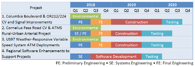
Figure 6: Project Schedule
14. Support or leveraging U.S. DOT's ITS Initiatives
Keep Oregon Trade Moving provides significant overlap with several of the DOT's ITS priority focus areas for the ATCMTD program. In particular, Keep Oregon Trade Moving prioritizes transportation elements associated with Smart Cities and builds off of many of the concepts and partnerships developed through the recent Portland proposal for the Smart Cities Challenge, including the strategies planned along the Columbia Boulevard corridor. This ATCMTD project facilitates the movement of goods and people along Columbia Boulevard and OR212/224 corridors using freight and transit signal priority at all of the intersections, signal performance measures that enable monitoring and reports against outcomes related to equity, safety, congestion, access, and mobility.
Connected Vehicle Technologies Deployment
Incorporation of connected vehicle technology in public and private sector fleets is another DOT focus area that corresponds with a key element of Keep Oregon Trade Moving. In particular, the weather-related information collected by CV-enabled Oregon DOT and Daimler fleet vehicles on US26 around Mt. Hood will provide a much more accurate and up-to-date picture of system performance and road weather safety conditions for this region where real-time information has historically been lacking.
National ITS Standards
Oregon DOT has extensive experience with implementing national ITS Standards. Doug Spencer, a member of this project team, serves as an AASHTO representative on the NTCIP joint committee. Oregon DOT has mature systems engineering processes that are followed on all ITS projects and current signal software procurement requirements are based on national standards. The Keep Oregon Trade Moving project team has the experience, expertise, and established processes necessary to implement national standards and U.S. DOT deployment guidelines on this project.
FHWA ATDM Program
Oregon DOT has been a major stakeholder to the FHWA Active Transportation and Demand Management (ATDM) program. Oregon DOT has participated in and coordinated with the FHWA ATDM program to develop its active traffic management approach, including incorporating FHWA's tools and methods for ATM performance analyses, benefit/cost analyses, training on effective ATDM systems, and deployment guidance from FHWA Division Offices.
1 Portland Region Westside Freight Access and Logistics Analysis, DKS Associates, October, 2013. [Return to Note 1]
2 ODOT, 2015. "2014 Crash Rate Book." Available at http://www.oregon.gov/ODOT/TD/TDATA/pages/car/CAR_Publications.aspx [Return to Note 2]
3 Mahumud, Maisha. 2014. "Evaluation of Truck Signal Priority at N Columbia Blvd and Martin Luther King Jr. Blvd Intersection: VISSIM Micro Simulation Analysis of Truck Signal Priority." Available at: http://pdxscholar.library.pdx.edu/cgi/viewcontent.cgi?article=1006&context=cengin_gradprojects [Return to Note 3]
4 FHWA, 2017. "Automated Traffic Signal Performance Measures (ATSPMs)." Available at: https://www.fhwa.dot.gov/innovation/everydaycounts/edc_4/atspm.cfm [Return to Note 4]