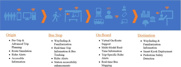
Integrated Real-Time Multi-Modal Accessible Travel Information System (IRMATIS)
CHAPTER 1: Project Description
1. Introduction
Metro Transit is pleased to submit this proposal to the USDOT for consideration as part of the 2017 ATCMTD Initiative.
Through its bus, light rail, and commuter rail services, Metro Transit helps people access jobs, education, healthcare, and other essential services throughout the region. To access these opportunities, however, people need to know that they can get from point A to point B reliably and predictably. This project seeks to fill critical information gaps that prevent people from using transit and, consequently, connecting to their community and accessing opportunities.
The Integrated Real-Time Multi-Modal Accessible Traveler Information System (IRMATIS), includes several components that will create a coherent, seamless integrated real-time multi-modal traveler information system. Specifically, this project will deploy new technologies to:
- Create new and enhance existing real-time multimodal data feeds,
- Provide accurate and up-to-date information throughout the trip,
- Ensure information is accessible to all riders, and
- Improve pedestrian safety.
A summary of each of these four categories follows.
Some components of the IRMATIS project will be implemented throughout the system and serve all Metro Transit riders. Other components will be focused on Metro Transit’s current and forthcoming arterial rapid bus lines: A Line (launched 2016), C Line (operations scheduled to begin 2019), and D Line (construction to begin 2020). The scope for each component of the project is described in more detail in Section 5.
Both the C Line and D Line pass through densely populated urban corridors, areas of concentrated poverty, employment centers, major employers, and key healthcare and other service providers in the area.
(1) New and enhanced real-time multimodal data feeds
The project includes the following new and enhanced data feeds. The information created through these feeds will be available to riders through a variety of channels including the Metro Transit mobile app, web site, public API (available for third-party apps or websites), electronic signs at stations, electronic signs on Rapid Bus vehicles, and Transit Information Center staff.
Data Feed |
Scope |
|---|---|
Real-Time Alerts for Detours, Disruptions and Delays |
System-wide |
Real-Time Adjusted Multi-Modal Traveler Options |
System-wide |
Enhanced Wayfinding |
A Line, C Line and D Line Rapid Bus Stations and surrounding partners |
Wheelchair Space Availability |
A Line, C Line and D Line Rapid Bus lines |
Bus Capacity |
A Line, C Line and D Line Rapid Bus lines |
Bike Rack Capacity |
C Line and D Line Rapid Bus lines (already available on A Line) |
(2) Accurate and up-to-date information throughout the trip
This project will deploy new technologies to ensure riders have accurate and up-to-date information throughout their trips. Specifically, this project includes expansion and enhancement of technologies to make information available at each stage of travel.
When in the trip? |
What does this project include? |
Where is this available?* |
|---|---|---|
Before departing and throughout the trip |
Enhancements to the mobile app, website and publicly available data feeds; communications integration with Transit Information Center |
System-wide |
At the transit station |
Beacons, pylon information, and other station amenities |
Rapid Bus Stations |
Smart kiosks |
Select locations |
|
On the bus |
On-board Customer Information System (CIS) |
Rapid Bus vehicles |
|
At the destination |
Beacons, pylon information, and other station amenities |
Rapid Bus Stations |
Smart kiosks |
Select locations |
* Some components of IRMATIS will be implemented throughout the system and serve all Metro Transit riders. Some components of IRMATIS will be focused on Metro Transit’s current and forthcoming arterial rapid bus lines: A Line (launched 2016), C Line (operations scheduled to begin 2019) and D Line (construction to begin 2020). The scope for each component is detailed in section 5.
(3) Ensure information is accessible to all riders
People with disabilities face special barriers to using transit and accessing the connections to jobs, resources, and services that transit provides. This project seeks to address those barriers to make transit accessible to all community members. While these solutions are designed for riders with disabilities, they offer potential benefits to all riders.
When in the trip? |
What does this project include? |
Where is this available?* |
|---|---|---|
Before departing |
Familiarization and orientation designed for accessibility. |
Rapid Bus service |
Throughout the trip |
Transit concierge service for riders with documented disability, including virtual on- route support |
System-wide |
Communication with caregivers |
||
At the transit station |
Beacons, pylon information, and other station amenities |
Rapid Bus Stations |
Smart kiosks |
Select locations |
|
On the bus |
On-board Customer Information System (CIS) enhancements for accessibility |
Rapid Bus vehicles |
At the destination |
Beacons, pylon information, and other station amenities |
Rapid Bus Stations |
Smart kiosks |
Select locations |
* Some components of IRMATIS will be implemented throughout the system and serve all Metro Transit riders. Some components of IRMATIS will be focused on Metro Transit’s current and forthcoming arterial rapid bus lines: A Line (launched 2016), C Line (operations scheduled to begin 2019) and D Line (construction to begin 2020). The scope for each component is detailed in section 5.
(4) Improve pedestrian safety
To advance the goal of access by all travelers in all modes to workplaces and services, Metro Transit is eager to partner with MnDOT on the Pedestrian Guidance and In-Vehicle Pedestrian Warning pedestrian-related elements that will be implemented as part of the MnDOT ATCMTD proposal. These include two innovative technological approaches developed in Minnesota and elsewhere to represent the leading edge in pedestrian assistance. First, pedestrian guidance includes aids for vision-impaired pedestrians. Second, in-vehicle and pedestrian warning includes general warning applications for both vehicle dashboard and personal devices
Overall Project Budget
The total project costs for all four project areas are estimated at $3,665,162 with a match amount provided by Metro Transit of $1,832,581.
2. Responding Entity
The Metropolitan Council (Council) is the regional agency of government for the Twin Cities metropolitan area. Centered on the cities of Minneapolis and Saint Paul, the area is made up of the seven counties of Anoka, Carver, Dakota, Hennepin, Ramsey, Scott and Washington. The metro area is home to three million people in seven counties and 186 cities and townships, encompassing nearly 3,000 square miles.
Metro Transit, an operating division of the Council, carries more than 82 million bus and rail passengers each year, provides transit service to 907 sq. miles of the region, operates 132 bus and rail routes, and was recently awarded the honor of 2016 Outstanding Public Transportation System of the Year by the American Public Transportation Association (APTA).
In 2017, Metro Transit identified five agency goals:
- Increase Mobility and Access to Opportunity
- Improve the Customer Experience
- Strengthen Sustainable, Prosperous, and Equitable Communities
- Develop a Healthy, Resilient, and Effective Workforce
- Maximize Operational Efficiency, Safety, and Financial Integrity
Metro Transit has a long history of implementing successful and innovative ITS deployments including:
- Regional CAD/ AVL system
- NexTrip Real-Time Transit Departure Times Deployments for Bus and Rail (Real-Time Signs, Web, Mobile Web, Mobile App, Trip Planner)
- Transit Commuter Information System (Bus/ Car Travel Comparison, Parking Space Availability, Next Bus Departure)
- Transit Signal Priority (TSP) on Route 10, Red Line, and A Line. Additional TSP planning is underway for Route 5, C Line, D Line, and METRO Orange Line.
- Transit Yard Management System
In addition, Metro Transit has several relevant innovative ITS deployments in planning or testing. This project builds on these planned deployments as detailed in Section 5.
These successful and planned ITS initiatives show the agency’s ability to deploy and manage cutting edge transit technologies, plus its dedication of continually seeking new and innovative ways to repurpose and enhance existing technologies and use data to improve transit operations and services to the public. This proposal leverages, enhances, and expands upon these previous deployments, plus introduces new innovative technologies that further advance the state of the art of transit technology systems, connected vehicle, and connected customer and community initiatives.
In addition, Metro Transit has experience working with customers and community partners to understand diverse riders’ needs and priorities. Metro Transit has built robust partnerships with social service providers, employers, educational institutions, and other community organizations that will be engaged to advance this project. Further, Metro Transit has expertise and experience with usability testing and information design.
The Program Manager for IRMATIS will bRedacted
Redacted
Redacted
3. Geographic Area and Jurisdictions Served
Some components of the IRMATIS project will be implemented throughout the system and serve all Metro Transit riders. Some components of IRMATIS will be focused on Metro Transit’s current and forthcoming arterial rapid bus lines: A Line (launched 2016), C Line (operations scheduled to begin 2019) and D Line (construction to begin 2020). The scope for each component of the project is described below.
Project Elements |
Scope |
Geographic Scope / Jurisdictions Served |
|---|---|---|
|
System-wide Improvements |
Metro Transit serves 90 cities in 7 counties across 907 square miles in the Minneapolis-St. Paul region. In 2016, Metro Transit provided 82.6 million rides. System-wide improvements will apply to all Metro Transit’s service area and riders. |
|
Rapid Bus Lines |
A Line – Metro Transit’s first arterial rapid bus line launched in 2016. The A Line serves neighborhoods in Minneapolis, St. Paul, Roseville and Falcon Heights. The A Line connects to both Metro Transit light rail lines. C Line – Metro Transit’s next arterial rapid bus line, scheduled to begin revenue service in 2019. The C Line connects downtown Minneapolis to Brooklyn Center Transit Center via Penn Avenue. D Line – Metro Transit’s third arterial rapid bus line, scheduled to begin construction in 2020. The D Line connects the Mall of America in Bloomington to Brooklyn Center Transit Center via downtown Minneapolis. |
|
Targeted locations |
Smart kiosks will be piloted at select strategic locations along Rapid Bus lines that serve infrequent riders, visitors, special event riders, high concentration of riders without access to smartphones, less familiar with Metro Transit applications. Pedestrian detection will be piloted at select strategic locations along Rapid Bus lines that see high bus volume and potential traffic / pedestrian conflict and safety concerns. |
The A Line, C Line, and D Line pass through densely populated urban corridors, areas of concentrated poverty where 50 percent or more of residents are people of color, major employment centers and employers, and key healthcare and other service providers in the area. The C and D Lines are substantial replacements for current routes with high ridership.
C Line
The entirety of the C line is located within, areas of concentrated poverty, or areas with high proportions of poverty and people of color. The core of the project serves many neighborhoods in north Minneapolis, an area with a poverty rate of 59% as of 2010. Substantial numbers of residents throughout the project area are transit-reliant without access to a personal vehicle, including high school students served by this project.
There are 127,871 jobs and 58,313 people living within a quarter mile of the C Line.
D Line
The Emerson-Fremont/Chicago Avenues Corridor (D Line) connects the City of Brooklyn Center with the Mall of America via downtown Minneapolis. Today, this area is served by Route 5. Route 5 is a critical component of the existing transit network that carries an average weekday ridership of about 17,000 rides per day. The service is Metro Transit's highest ridership bus route. The D Line will have 57-61 unique stations and 13 shared stations with the C Line.
The Emerson-Fremont and Chicago Avenue corridors are bother in areas of concentrated poverty, or an area with high proportions of poverty and people of color. The poverty rate within this part of South Minneapolis was 64% in 2007-2011. Substantial numbers of residents throughout the project area are transit-reliant without access to a personal vehicle.
2018: Pending full funding, the C Line will be constructed in 2018, along with coordinated street improvements on Penn Avenue.
2019: The C Line is scheduled to open for revenue service in 2019 on Olson Memorial Highway, pending full funding.
Future: A future potential realignment to Glenwood Avenue would occur in coordination with light rail transit opening on Olson Highway and the completion of stations on Glenwood Avenue.
4. Issues and Challenges the Project Addresses
Each of these proposed technology deployments addresses specific real-world issues and challenges for riders. Indeed, all four aspects of this project – (1) new and enhanced data feeds, (2) providing information throughout the rider’s trip, (3) making information accessible, and (4) pedestrian safety – are designed around closing known gaps and issues with customer information. Each component is detailed below.
(1) New and enhanced real-time multimodal data feeds
Riders want the ability to make choices regarding their travel. Currently, riders face several challenges with information systems when taking public transportation:
- Lack of necessary information to make travel choices, particularly when traffic, inclement weather, and other conditions cause delays and disruptions.
- Insufficient integration between customer information elements. For instance, rider alert and disruption information is not integrated with real-time departure estimates or available at the trip-level. Bike and car share availability is not integrated into trip plans.
- Information is generally one-size-fits-all and not customized to an individual’s needs or preferences. For instance, a rider in a mobility device may need information about whether snow has been cleared from a station before they depart. Other riders may be most concerned with where to connect to bicycle paths or car share vehicles.
This project will enhance current information data feeds, while creating new data feeds that are completely integrated into a singular customer experience. This gives customers the ability to make confident choices in travel. This includes:
- Integrated real-time, bus mapping, and rider alert information for on-board customer information systems
- Personalized trip preferences with real-time alerts and transit alternatives
- Wayfinding and orientation information
- Real-time capacity, bike rack, and wheel-chair space availability
- Pedestrian detection
This aligns with the goals of the initiative by integrating advanced technologies into transportation system management and operations as well as improving mobility, reducing congestion, and providing efficient and accessible transportation.
(2) Accurate and up-to-date information throughout the trip
Riders need information before they depart, at stops or stations, on the bus or train, and at their destination. Riders frequently face these challenges:
- Inconsistent information
- Lack of access to information about transit alternatives
- Poor or inadequate wayfinding or rider orientation
- Lack of information integration from different sources
These issues create uncertainty and confusion, reduce rider satisfaction, and force riders to seek other transportation options or forego jobs and other opportunities.
This project will implement new tools and technologies throughout the trip to address these issues, including:
- Advanced trip-planning and pre-trip familiarization
- Station information available in multiple formats
- On-vehicle information and communication
- Wayfinding and orientation information
- Trip-specific real-time and rider alert information
- Multi-modal transit options
This aligns with the goals of the initiative the collection, dissemination, and use of real time transportation information, improving mobility, and providing safe, reliable, and affordable connections to employment, education, healthcare, and other services.
(3) Ensure information is accessible to all riders
Riders with low-vision or blindness, hearing impairments, cognitive, and/or mobility issues face unique challenges while taking public transportation.
- Information may not accessible or available in a format that can be understood.
- Inconsistent placement of amenities and information make stations difficult to navigate.
- Lack of accessible transit assistance and support means trips cannot be taken with confidence in the rider’s safety.
These deficiencies lead riders to seek other, more-expensive transportation services. This project will implement enhancements to make information accessible to all riders throughout their journey, including:
- Advanced trip planning, including virtual tours and trip simulation,
- Station information available in multiple formats,
- On-vehicle information and communication available in multiple formats,
- Station and local area information available in multiple formats,
- Virtual concierge service and support, and
- Communication with caregivers.
This aligns with the goals of the initiative by deploying technologies and systems that allow public agencies to provide improved mobility services to at-risk users such as elderly, disabled, and other individuals that require transportation assistance.
(4) Improve pedestrian safety
Pedestrian-related crashes have recently reversed a long downward trend in Minnesota to return to their 2006 levels. After a decrease to 818 total crashed in 2014, the number jumped to 911 in 2015, with 41 of these crashes being fatal for the pedestrian. In fact, a pedestrian crash is five times more likely to be fatal than a single or multiple vehicle crash.
Most pedestrian-related crashes in Minnesota occur at signalized intersections where speed limits are 35 MPH or lower. The chief contributing factors for drivers involved in pedestrian crashes are Failure to Yield Right-of-Way (38%) and Driver Inattention or Distraction (20.5%). If drivers can be made more aware of pedestrian presence and can be alerted so that their attention is called to the crosswalk area, nearly 60% of crashes might be avoided.
Pedestrian behavior also contributes to crashes, with pedestrians crossing without a proper walk signal or excessive time taken to enter or traverse a crosswalk. Assisting pedestrians with requesting a “walk” signal, guiding them to the crosswalk and ensuring the “walk” indication remains active for the duration of their crossing has the potential to reduce an additional 24% of all accidents where these are contributing factors.
5. Transportation Systems and Services Included
This project includes several components that will create a coherent, seamless integrated real-time multi-modal traveler information system. Specifically, this project will deploy new technologies to:
- Create new and enhance existing real-time multimodal data feeds,
- Provide accurate and up-to-date information throughout the trip,
- Ensure information is accessible to all riders, and
- Improve pedestrian safety.
A description of each project component follows.
(1) New and enhanced real-time multimodal data feeds
1.1 Real-Time Bike Rack Capacity Information Expansion
Metro Transit currently has bike rack sensors installed on all 13 A Line buses. These sensors are integrated into TransitMaster CAD/AVL system and bike use data is sent from the buses in real- time. Each bike sensor message sent from the bus is date/ time stamped and contains data on GPS location, route/block, travel direction, bus ID, and other characteristics. The data produced by these sensors is used for two primary purposes: (1) To provide customer information and (2) Data Analytics – to analyze and report on bike usage and boarding/alighting patterns within the transit system and to guide facilities planning and additional rack capacity needs. Lack of bike rack space and not knowing about bike rack availability is a complaint from customers who depend on combining bicycling with transit to complete their trips. Making this information available to customers fills a known gap and helps address a known issue. Plans are currently underway to display bike slot availability to riders in real-time on the Metro Transit mobile app and other customer information sources. With this proposal, Metro Transit will expand bike rack sensors and TransitMaster integration to all C Line and D Line buses to maintain the Metro Transit rapid bus standard. This initiative will include installing the bike rack sensors on 12 C Line and 24 D Line buses for a total of 36 additional installed buses.
1.2 Rollout of Real-Time Bus Space Availability Information
Most of Metro Transit buses are equipped with automatic passenger counters (APC). These APCs at the bus front and rear doors detect boardings and alightings and transmit these messages in real- time to the TransitMaster CAD/AVL system database. Knowing the seated and standing bus capacity, these messages can be analyzed to compare the current passenger count on the bus to its capacity load and calculate how full the bus is in real-time.
Metro Transit is currently in the process of converting its bus fleet to use cellular communications as its primary method of transmitting TransitMaster CAD/AVL system mobile data. Once this data communication conversion is complete, APC messages are planned to be transmitted in real-time. With this proposal, it is planned to have Bus Space Availability Information available for A Line, C Line, and D Line service. This real-time information will be made available via the Metro Transit app, as well as other customer information sources and will provide the rider real-time relevant information to make decisions impacting their journey. These rapid bus routes will allow Metro Transit to test the service and information feed before making it available throughout the system.
1.3 Rollout of Real-Time Wheelchair Space Availability Information
All of Metro Transit buses are equipped with wheelchair lifts or ramps and designated wheelchair securement locations. Metro Transit is currently in the process of converting its bus fleet to use cellular communications as its primary method of transmitting TransitMaster CAD/AVL system mobile data. Once this data communication conversion is complete, wheelchair lift messages will be transmitted in real-time.
With this proposal, Metro Transit plans on development to use the current Wheelchair Stowed discrete information in the CAD/AVL system to detect if the securement zone(s) are occupied and send messages in real-time to the TransitMaster AVL/CAD system database when the securement zone occupied status changes. This development will encompass the required associated hardware and interface to the TransitMaster AVL/CAD system. This real-time information will be made available the Metro Transit app, as well as other customer information sources and will provide the rider real-time relevant information to make decisions impacting their journey.
(2) Accurate and up-to-date information throughout the trip
2.1 Multi-modal Data Integration with Trip Planner
Trip planner functionality must be developed to provide recalculated travel options when a portion of an existing trip is delayed or disrupted. This includes integrating real-time vehicle location information for connecting service and detour and disruption information so a rider knows if they may miss a transfer and can see their multi-modal options for completing their trip.
2.2 Customized Traveler Information Integration
Travelers have unique needs and preferences for how they complete their trip. Some riders are willing to walk farther for a faster trip and others may have limited ability to access certain stops and stations. Likewise, some riders take only one bus at the same time each day and only care about disruptions that affect their trip while others may need information about service throughout the day. Allowing riders to customize their travel and notification preferences means they will have the information they need to complete their trips confidently.
This project includes development within the Metro Transit website and mobile app to allow riders to set trip and personal preferences. This personalized platform will allow riders to access information throughout their trip. Riders will be able to receive trip-specific information for these routes including real-time adherence, rider alerts, and multi-modal options.
2.3 Beacon Deployment and Integration
Beacons will be installed at all Rapid Bus stations. Beacons will provide wayfinding and familiarization information, as well as real-time bus departures and mapping. Content will be developed and pushed to smart devices through the mobile app. Development work will allow content to be pushed in multiple formats including visual, audio, haptic, and augmented and virtual realities. Beacon technology allows for unique content to be pushed to riders based on their needs.
2.4 On-board CIS Enhancements and Expansion
Metro Transit is currently in the process of implementing a customer information system (CIS) on all 13 A Line buses. These buses, as well as all Metro Transit buses also have a high speed mobile router installed. The router is capable of 4G LTE data communication speeds, providing GPS location data, internet access, and interfaces to other devices/ systems on the bus. The CIS builds on this core functionality to provide real-time bus location and other transit customer information. This initial rollout will have the on-board displays show the real-time location of the bus related to its scheduled bus stops, NexTrip real-time departures of routes at upcoming transfer locations, and pertinent rider alerts and disruption notices. The implementation on A Line buses will be completed by December 2017.
This proposal plans to add the CIS to all C Line and D Line buses and to greatly enhance and expand its functionality and information content for transit riders.
2.4.1 On-Board CIS Improve Accuracy through TransitMaster Integration
The on-board CIS is currently a standalone system on Metro Transit A Line buses. The CIS uses a cellular connection to connect to a hosted system to download required data for the display. Key pieces of data already reside on the CAD/AVL system (TransitMaster) that will enhance the capabilities and performance of the CIS, resulting in less data latency and downtime. With the proposal, Metro Transit will develop an interface between the CIS and TransitMaster CAD/ AVL system. This development will allow information from TransitMaster to be broadcasted through the on-board router. The CIS can then use this data for the on-board display. This will reduce the data transfers across the network by using data already on the bus and thereby make the CIS more accurate.
2.4.2 On-Board CIS Expansion to C Line and D Line
Metro Transit is currently in the process of implementing an on-board customer information system (CIS) on all 13 A Line buses. A Line buses will be providing enhanced traveler information to transit riders through the CIS. This initiative will include installing the NexTrip Mobile CIS on 12 C Line and 24 D Line buses for a total 36 total additional buses.
2.4.3 On-board CIS Integration with Metro Transit Mobile App
Metro Transit has implemented a mobile app for smartphones. The app provides the user the ability to plan a trip, see arrival information for bus and trains and buy transit tickets. The Metro Transit app is a tool to make riding easier and improve the transit customer experience. With this proposal, Metro Transit plans to integrate the CIS with the Metro Transit smartphone app. This integration will provide a seamless source of pertinent transit data to the customer as they flow through their journey. As the on-board CIS is expanded throughout the system, so will the integration with the Metro Transit smartphone app.
2.5 Smart Kiosks
While regular riders know how to access transit information through the mobile app or other customer information tools, this project seeks to ensure that infrequent riders have access to the same integrated real-time multi-modal information. The project includes developing and deploying smart kiosks at a few strategic locations that serve visitors and other high volumes of infrequent riders as well as providing an additional information option for riders without smartphones. The kiosks will be designed for accessibility and clarity. The kiosks will provide multi-modal trip planning, with integrated real-time service alerts and departure information along with wayfinding and other essential information.
(3) Ensure information is accessible to all riders
3.1 Stop Request and Device to Bus/Operator Communication
The CIS on A Line buses has the ability to link and sync with the Metro Transit smartphone app through the bus WiFi system. When linked to the smartphone app, the user will have the ability to see on their smartphone the same content as the on-board CIS display, plus more options. One of these options is the potential to send and receive stop request messages while the customer is on the bus. With this proposal, Metro Transit plans to utilize and further develop this option to further enhance the accessibility options for its transit riders and will initially be made available on the A Line, C Line, and D Line service.
3.2 Audio Functionality Enhancements
With this proposal, Metro Transit plans to upgrade and enable the audio capabilities in the CIS. This will enable riders to hear as well as see information that is being delivered on the information screens. Valuable information concerning trip planning and connections will be provided as well as any rider alerts or safety information. This makes the information accessible to more riders.
3.3 Transit Concierge Service for Riders with Documented Disability
To help facilitate transit use for riders with disabilities, this project seeks to enhance trip planning and provide on-trip assistance. Pre-trip services and advanced trip planning enhancements include several components. Trip planning results will be redesigned for people with blindness, low-vision, cognitive and/or mobility issues, including providing information in multiple formats. Detailed trip plan results will be updated to include photos, landmarks, and contextual details alongside step-by-step instructions. Riders without a smartphone would be able to print the trip plan results and save or share them in other formats. Further, riders would be able to access a pre-trip route simulation (e.g., what the on-board annunciators will say, what you will see, etc.) so they can prepare and feel confident on their trip.
In addition to pre-trip services, this project includes improvements for when the rider is on their trip. This virtual on-route support includes automated announcements provided through a smart device as the customer travels. In addition, priority Staff assistance is available through phone, chat or text throughout the trip. The rider would be able to share their location with staff to facilitate providing information.
Finally, the transit concierge service includes communication with caregivers. Through the mobile app, riders would be able to share their location with caregivers to confirm their destination has been reached.
(4) Improve pedestrian safety
Transportation infrastructure investments have typically focused on motorized vehicles, whether private automobiles, commercial vehicles or transit. Metro Transit recognizes the importance of pedestrian-oriented development and walkable, “livable” communities.
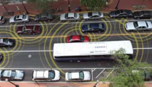
To advance the goal of access by all travelers in all modes to workplaces and services, Metro Transit is eager to partner with MnDOT on the Pedestrian Guidance and In-Vehicle Pedestrian Warning pedestrian-related elements that will be implemented as part of the MnDOT ATCMTD proposal. These include innovative technological approaches developed in Minnesota and elsewhere to represent the leading edge in pedestrian assistance.
The graphic below illustrates the overlapping systems used to improve the safety and efficiency of pedestrian movements.
- Pedestrian Guidance – Specific aids for vision-impaired pedestrians.
- In-Vehicle and Pedestrian Warning – General warning applications for both vehicle dashboard and personal devices
4.1 Pedestrian Guidance
In 2012, the University of Minnesota created a system to enhance the safety and accessibility pedestrian crossings for vision-impaired pedestrians. The Mobile Accessible Pedestrian Signals (MAPS) system. This novel application used a simple interface to the local signal controller and wireless communications to send pedestrian crossing status with a cell-phone application. Combined with advanced mapping, the application could provide pedestrians with directional information for the crossing. Text-to-speech technology ensure that messages were available regardless of vision impairment.
In addition, the pedestrian could use the application to wirelessly request a pedestrian crossing “call” without having to search for the location of a hard-wired call button. Figures 1 and 2 below illustrate the system operation. A single tap on the smartphone interface will provide information about the crossing.
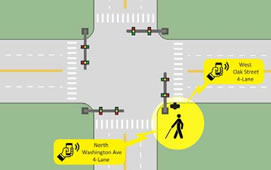
Figure 1 - Single Tap to Obtain Intersection Geometry
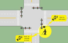
Figure 2 - Double-Tap to Confirm Crossing and Obtain Signal Information
A double-tap on the application will provide information on the “walk” time remaining and, depending on orientation, make a request for a pedestrian crossing.
An extensive research project validated the usefulness of the MAPS system. Time savings were substantial, with the in- position time (time from passing a pushbutton pole to waiting at the beginning of crosswalk) was reduced from an average of 38.4 second for a standard pushbutton to 9.8 seconds with MAPS.
Surveys of a test sample of vision-impaired pedestrians further validated the usefulness of MAPS. MAPS was preferred by nearly a 3 to 1 margin over a standard pushbutton. Those stating the MAPS provided useful information about intersection geometry outnumber those who didn’t by a 5 to 1 margin.
This impressive technology has been developed further to include information about temporary crosswalk obstructions to work zones and designs are in place to enable project managers to easily input data about changing conditions from the job site with a smartphone application.
In this proposal, Metro Transit will coordinate with MnDOT to deploy the MAPS system at the intersection of 7th Street North & Olson Memorial Hwy (State Hwy 55). This location was chosen as this will be a common connection point for the C Line and D Line rapid bus service and within one block of the major Transit Station servicing the Green and Blue Line light rail lines, plus the Northstar Commuter Rail service. This technology is planned to be integrated into the Wayfinding and Mobile App initiatives of the Metro Transit proposal. This will further enhance the safe/seamless journey and connected community vision of the Metro Transit proposal and will improve the safety of pedestrians and the efficiency of vehicle traffic due to the shorter (approximately 2 seconds) times taken between a walk signal and entering the crosswalk at this very busy intersection.
4.2 Pedestrian Warning System
Distracted driving is an increasing concern in transportation safety. In 2015 alone, 3,447 deaths were directly attributable to distracted driving. Pedestrian-related crashes number over 70,000 per year. While the National Highway Traffic Safety Administration encourages a number of approaches involving education and advocacy to reduce distracted driving, more direct options are also available.
In-vehicle warnings of pedestrian presence can help reduce vehicle-pedestrian crashes. Vehicle sensor systems provide one mechanism, but novel systems integrated with DSRC hardware at intersections enable in-vehicle warning for vehicles that lack sophisticated sensors that can detect pedestrians.
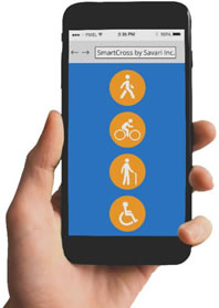
The USDOT SmartCross smartphone application is the basis for enabling a suite of pedestrian- infrastructure services. When used in combination with an in-cabinet device, pedestrians can be located if in the crosswalk, and a signal broadcast over the DSRC communications link to vehicles in the area. This signal can then activate an in-vehicle warning, increasing the probability that a driver will know a pedestrian is present and providing Figure 3 - SmartCross Application Interface additional reaction time.
In this proposal, Metro Transit will coordinate with MnDOT as needed to deploy the USDOT SmartCross technology at the intersection of 7th Street North & Olson Memorial Hwy (State Hwy 55). The agency will also install DSRC technology on an agreed upon on C Line and D Line ABRT buses. This location was chosen as this will be a common connection point for the C Line and D Line ABRT service and within one block of the major Transit Station servicing the Green and Blue Line LRT, plus the Northstar Commuter Rail service.
Metro Transit also is aware of concerns about pedestrian distraction and will work with MnDOT and the USDOT to enhance the SmartCross technology as needed to provide alerts to pedestrians of approaching buses through the DSRC technology and associated apps. This technology is also planned to be integrated into the Wayfinding and Mobile App initiatives of the Metro Transit proposal. This will further enhance the safe, seamless journey, and connected community vision of the Metro Transit proposal.
6. Deployment Plan
Metro Transit has a long and proven history of deploying large scale and complex Intelligent Transportation System projects. With each project, the agency grows its knowledge base, experience, and lessons learn to try to make each subsequent deployment more successful.
Because of the number of integrated elements of this proposal, plus the level of coordination required for a successful overall project, Metro Transit will rely heavily on the systems engineering for ITS approach. Metro Transit believes in this approach for ITS deployments and has used it successfully in deploying equally large or larger deployments in the past.
Metro Transit will solicit the services of a proven ITS focused design and engineering firm to help guide and coordinate the projects and project managers through the system engineering process to successful system implementation, testing, and acceptance. This process also allows for a project evaluation and lessons learned phase at the end of the project. This project is very scalable within our agency and can be replicated by other agencies.
Following a detailed needs assessment, the concept of operation phase will be crucial to the overall project success. The scenarios developed in this phase and subsequent outcomes that result will set the stage for successful project coordination and integration. Project coordination and integration will be two of the most significant technical considerations of this project.
To ensure a successful deployment, the smaller elements that make up of the overall project have been grouped together by function and lead by a project manager who has expertise in each of the identified functional areas. These functional areas and associated project managers are as follows:
Functional Area |
Project Manager |
|---|---|
Mobile Technologies |
Rick Paulson |
Connected Vehicle/ Station Technologies |
Hoki Tse |
Smart Wayfinding and Navigation |
Ben Rajkowski |
Advanced Accessible Traveler Information |
Laura Matson |
This project is not required to be installed by the startup of the C and D Line openings in 2019 and beginning construction in 2020. However, to enhance the customer experience, it will be our plan to have the CIS installed on the new rapid buses in time for the startup of each of these new transit services. This is reflected in our project deployment approach and schedule. The project is divided into two main phases: (1) C Line Deployment; (2) D Line Deployment.
- Phase 1 - This deployment phase will follow the system engineering process through C Line installation, testing and start up.
- Phase 2 – This deployment phase will incorporate the evaluation and lessons learned from Phase 1 to review and update the Needs Assessment, Concept of Operations, Requirements, plus High and Detailed Design so the appropriate changes and improvements can be applied to the D Line deployment.
An ongoing operations and system maintenance/ support plan will be developed to ensure roles and responsibilities are known to insure long term system viability and reactive/ proactive maintenance is provided.
7. Regulatory, Legislative, or Institutional Challenges
Metro Transit has enjoyed productive and cooperative relationships with Federal, State, and Local entities, including other transportation system stewards in the region for many years. The services proposed are complimentary to existing functions for all the potential agencies involved and no regulatory or legislative obstacles are anticipated that cannot be addressed within the context of the project.
Metro Transit:
The proposed project area of the C Line and D Line cross jurisdictional lines within the Metro Transit Service Area and will require coordination between different departments. The core group of the project leadership come from the Transit Technology Systems for Bus Operations and the Transit Information departments. However, personnel from a variety of departments will be involved for this successful project deployment. This is not seen as an obstacle as these inter- departmental relationships are strong and have a long history of successful project implementations. Transit Technology Systems will lead the Mobile Technologies and Connected Vehicle/ Station Technologies related projects. Transit Information will lead the Smart Wayfinding and Navigation and Advanced Accessible Traveler Information projects.
Between Metro Transit and other Government Agencies:
Metro Transit has a long history of successful partnerships and project coordination. No issues related to inter-governmental agreements are anticipated.
External to Project Participants:
By their nature, CV applications rely on exchange of information between devices. The MnDOT MnFAST Initiative applications will broadcast and receive data via DSRC. Metro Transit is planning on installing DSRC radios on C Line and D Line buses for the Pedestrian Warning System Project to coordinate with MnDOT if the proposal is selected. The risks associated with information security range from casual probing of the system by interested or curious citizens to malicious attacks performed by nation-state actors wishing to cause property damage or injuries for their own purposes. The potential damage from attacks also spans a wide spectrum from minor increases in system latencies to fatalities and expensive infrastructure damage.
Mitigating this threat will rely on the Security Credential Management System (SCMS) being developed by the USDOT. The SCMS is not yet fully functional and available for production systems, however. The lack of a securing mechanism will limit the future roll-out of connected applications, but is not anticipated to hinder the foundational projects included in MnFAST and Metro Transit involvement. Met Council Information Systems Security will evaluate the project planned systems and each will need to adhere to the Met Council Information Systems Security and Data Practices requirements.
8. Performance Improvements
This project will implement technologies that will have measurable impacts. The four project initiatives will provide significant improvements for riders’ ability to access transportation services, reduce customer uncertainty and confusion, increase access to opportunity, and reduce obstacles to information. Listed below are the four project categories and unique elements that improve access to transportation services, optimize efficiency, and lead to a reduction of congestion and costs:
Create new and enhance existing real-time multimodal data feeds
- Bus space availability data
- Bike rack space availability data
- Wheelchair space availability data
Provide accurate and up-to-date information throughout the trip
- Real-time rider alerts
- Real-time emergency messaging
- Trip-specific information
- Real-time multi-modal trip options
- Customized and personalized transit information
Ensure information is accessible to all riders
- Pre-trip and advanced trip planning
- Virtual on-route support
- Communication with caregivers
- Customized and personalized transit information
- Audio functionality enhancements
- Stop request and device to bus/operator capability
Improve pedestrian safety
- Pedestrian Guidance
- In-Vehicle and Pedestrian Warning
9. Benefit Projections
When information fails to meet peoples’ needs they lose confidence in public transportation and look for alternatives, like driving alone. This has obvious congestion and environmental impacts. For transit-dependent populations, this lack of confidence limits access to opportunity and the ability to fully interact with the community in which they live. Information systems are key transportation systems and improving their efficiency will be a measurable benefit of this project. The following rider scenarios show real-life examples of how this project will have mobility and environmental benefits, along with potential improvements to information system efficiency and congestion.
Regular rider commuting to and from work daily
This rider used the trip planner and knows the specific route they take and train they transfer to every day. Their bus is delayed by 7 minutes and when they arrive at the rail station, their train has already left. They don’t have any idea of what other options they could take, if any. Since they need to be at work on time, they have lost trust in public transportation as a reliable, efficient travel option. They have their own vehicle and will start driving to ensure they arrive to work on time.
This project benefits this rider in these ways:
- Riders will have access to advanced trip planning to provide additional travel options before they start their trip.
- Riders will receive alerts when a portion of their trip is delayed or disrupted. They will receive alternative transit options and transfer points to make it to their destination successfully.
- Through the same platform, they will have options to chat, text, or call a transit expert for assistance.
Providing this information will keep this rider in transit and out of a single-occupancy vehicle, which offers environmental benefits and congestion mitigation.
Rider with low vision taking transit for daily activities
This transit-dependent rider arrives at the transit station and is unable to read static wayfinding and transit information at the station. A bus approaches and they are unsure if it is what they need. They walk up to the boarding area and ask the driver who informs them they need to wait at another gate. They struggle to find this gate to await the bus. When they finally board the bus, they cannot hear the overhead stop announcements. They are forced to get up and ask the operator. When they get off the bus, they are unsure of where to go. The whole process is frustrating and makes the rider feel unsure about being able to take public transportation and therefore access opportunities.
This project addresses the issues faced by this rider in these ways:
- Riders have access to beacon technology and integration with mobile app allow riders to access station amenities and transit information in multiple formats, including visual, audio, haptic, and augmented/visual reality.
- Station-level information presented in multiple formats including tactile maps and push- button audio announcements.
- Riders will have access to advanced trip planning to include virtual tours of station platforms.
- Riders will access real-time on-board information including upcoming stops and stations.
- Riders can request stop from smart device
- Riders can access integrated wayfinding information to guide them to their destinations.
Providing this information improves mobility for this rider, benefiting the rider experience and system efficiency.
System Performance Improvements
10. Vision, Goals, and Objectives
Metro Transit’s vision for this project is to develop an integrated real-time multi-modal accessible traveler information system that fills known gaps and addresses known barriers to using transit. The project’s four primary initiatives seek to create a seamless, integrated experience for riders while removing uncertainty and confusion that are barriers to public transportation. Each of these initiatives address real-life challenges addressed in section 4 and provide the foundation for a complete, integrated, and seamless rider experience.
Metro Transit Goals
In 2017, Metro Transit identified five agency goals. This project aligns with and supports four of these goals.
- Goal 1: Increase Mobility and Access to Opportunity – Providing critical information and ensuring that the information is accessible means more people will be able to access the mobility options that Metro Transit provides.
- Goal 2: Improve the Customer Experience – Every aspect of this project – from developing new real-time data feeds to presenting that information in varied customer- friendly ways is designed to improve the customer experience.
- Goal 3: Strengthen Sustainable, Prosperous, and Equitable Communities – Integration with external data sources (e.g., bike share and car share availability), connections to employment and service centers, and a project design rooted in community-driven enhancements all align with this goal.
- Goal 4: Maximize Operational Efficiency, Safety, and Financial Integrity – Data generated through this project will help Metro Transit identify rider patterns to allow for more effective scheduling and facility improvements.
Future Related Deployments
Metro Transit anticipates that corridor and site-specific deployments will serve as a scalable model for system-wide improvements. Evaluation will be done to measure success of each new and enhanced technology element. Successful elements would be part of system-wide initiatives where that scalability makes sense.
Additionally, Metro Transit envisions the success of this project to be reproducible for other agencies facing similar issues. The ability to share and transfer knowledge gained from this project is a key objective for the agency.
11. Partnering Plans
Metro Transit has a long history of partnering with both public and private entities to implement, operate, and maintain successful and leading edge Intelligent Transportation Systems (ITS) projects in the Minneapolis/ St. Paul region. In 2016, the Association Public Transit Association (APTA) recognized Metro Transit as ‘System of the Year’ in part due to its forward thinking, technology innovations, and public/ private partnership developed over the years to become a leader in the transit industry.
Over 20 years ago, Metro Transit partnered with MnDOT and other public-private entities on the pioneering ORION project, which brought together State, county and city agencies with both large and small private businesses to provide multimodal solutions to the public while providing incentives for private industry to invest in the field. Similar and more recently, Metro Transit has partnered with public-private entities on the Urban Partnership Agreement (UPA), Integrated Corridor Management (ICM), and A Line rapid bus. This history continues today and will be carried into the future with projects such as C Line, D Line, and METRO Orange Line Rapid Buses and Route 5 Transit Signal Priority (TSP).
Metro Transit is aware of the MnDOT ATCMTD application and is prepared and excited to partner on its MnFAST initiative. The two agencies will continue to look for opportunities to work together as they deploy Connected Vehicle and other ITS technologies.
Within the Metro Transit proposal, the agency will be seeking partnerships with local businesses and public entities to enhance the connected community and seamless traveler journey vision of this project. It is envisioned that partnering with these entities will be cost-neutral for the project. No net increase in costs or funding needs will be incurred as a result their involvement.
12. Existing Systems Leveraged
Metro Transit has been a transit industry leader in developing, deploying, operating, and maintaining transit ITS technologies for many years. In addition to looking for ways to utilize new technology, a key to the Metro Transit vision for implementing ITS is to leverage its initial technology investments by looking for and implementing new innovative ways to use and enhance existing technology in ways beyond its initial intent. An example of this is the existing Transit Signal Priority system on Metro Transit buses. This technology is now also used to open gates at facilities requiring a high level of security; to supplement the existing CAD/AVL system with highly accurate dead-reckoning technology when the normal CAD/AVL GPS signal is lost; to wirelessly connect to and trigger a pulsing light beacon at A Line stations signaling the pending actual arrival of an approaching bus.
For this proposed project, the following existing systems/ technologies will be leveraged:
- On-board CIS – integration with TransitMaster CAD/ AVL Mobile System and Metro Transit App; expansion of the system to C Line and D Line rapid buses.
- TransitMaster CAD/ AVL Mobile System – integration with On-board CIS
- Metro Transit App – integration with On-board CIS
- TransitMaster Bike Rack Sensor Subsystem – expansion to C Line and D Line buses
- TransitMaster Automatic Passenger Subsystem Data – expansion to C Line and D Line buses
For this proposed project, the following new systems/ technologies will be deployed:
- Bluetooth Beacons
- Dedicated Short Range Communication and integration with MnFAST System
- TransitMaster Wheelchair Sensor Subsystem
- Smart Kiosk Technology
As this proposed project progresses, Metro Transit will remain flexible to adjust the systems and mentioned integration as needed based on the outcomes produced through the systems engineering process.
13. Schedule
The IRMATIS project is planned over three years with completion planned for early 2021. As discussed in the deployment plan, this project will aim to align with the implementation of the C Line and D Line Projects. The C Line is planned to open for revenue service in 2019 and the D Line is scheduled to begin construction in 2020. While this project is not required to be installed by the startup of these two projects, to enhance the customer experience Metro Transit aims to meet these timelines. This is reflected in our project deployment approach and schedule.
The project is divided into two main phases: (1) C Line Deployment and (2) D Line Deployment.
- Phase 1 - This deployment phase will follow the system engineering process through C Line installation, testing and start up.
- Phase 2 – This deployment phase will incorporate the evaluation and lessons learned from Phase 1 to review and update the Needs Assessment, Concept of Operations, Requirements, plus High and Detailed Design so the appropriate changes and improvements can be applied to the D Line deployment.
Task / Milestone |
Start |
End |
|---|---|---|
Notice of Award |
9/1/2017 |
9/30/2017 |
Project/ Contract Setup |
10/1/2017 |
12/31/2017 |
Phase 1: Needs Assessment and Requirements Documentation |
1/1/2018 |
5/31/2018 |
Phase 1: High-level and Detailed Design |
6/1/2018 |
8/31/2018 |
Phase 1: C Line Deployment and System-Wide Enhancements |
9/1/2018 |
4/30/2019 |
Phase 2: Needs Assessment and Requirement Documentation |
5/1/2019 |
7/31/2019 |
Phase 2: High-level and Detailed Design |
8/1/2019 |
10/31/2019 |
Phase 2: D Line Deployment |
11/1/2019 |
8/31/2020 |
Evaluation |
9/1/2020 |
12/31/2020 |
Final Report |
1/1/2021 |
3/31/2021 |
Program Manager Gary Nyberg will work closely with the USDOT/FHWA Project Manager to manage all aspects of the project including scope and schedule. This includes performing the necessary coordination to ensure all potential issues and risks are addressed in a timely manner, and keeping the project on schedule.
14. ITS Program Initiatives Leveraged
The ITS 2015-2019 ITS Strategic Plan from the U.S. Department of Transportation Joint Program Office (JPO) outlines specific program goals in six areas. These are:
- Connected Vehicles – Integration with legacy systems, benefit/cost lessons and local agency deployments.
- Automation – Define core elements and performance criteria, test concepts and define the Federal role.
- Emerging Capabilities – Use technologies for real-time needs, meet public policy objectives and integrate new technologies.
- Enterprise Data - Integrate new data sets, identify data management models and enable new business relationships.
- Interoperability – Follow the National ITS Architecture, inventory interfaces for standardization, harmonize standards and facilitate the testing and certification process.
- Accelerating Deployment – Define mechanisms to encourage public and private investment, develop analytic tools and establish tools to support the new user base.
The project categories planned for this ITS deployment are described in Volume 1, Section 5 of this proposal. A summary of how each of these categories relate to the ITS Strategic Plan is provided below.
Accurate and up-to-date information throughout the trip – This initiative will deploy emerging and innovative ways to utilize Bluetooth Beacons and integration to transit applications. This initiative will further advance methods of collecting, storing and analyzing the data that is produced from journey beginning to end. As this is an emerging technology in its applicability to transit wayfinding, the project team will work with the DOT to integrate existing interoperability standards into the project and assist developments of standards where they do not exist today.
Ensure information is accessible to all riders – Rider access to the tools and information is at the heart of this initiative. The seamless access to information and the smooth transition between emerging and innovative use of technologies and locations as the traveler moves through each mode of travel to journey end will be implemented with this proposed project. This initiative will further advance methods of collecting, storing and analyzing the data that is produced from journey beginning to end.
New and enhanced real-time multimodal feeds – Rider access to the tools and information is at the heart of this initiative. The CIS is one of the enabling tools that provide the seamless access to information and the smooth transition between emerging and innovative use of technologies and locations as the traveler moves through each mode of travel to journey end will be implemented with this proposed project. The CIS Initiatives will further advance methods of collecting, storing and analyzing the data that is produced from journey beginning to end.
Improve pedestrian safety – The Pedestrian Detection/ Warning System utilizes DSRC to enable V2I communication between transit bus and intersection traffic control system and pedestrian detection device, leveraging the emerging communication technology to provide real-time safety enhancements.
A summary of how each of the proposed projects relate to the ITS Strategic Plan is shown below.
Connected Vehicles |
Automation |
Emerging Capabilities |
Enterprise Data |
Interoperability |
Accelerating Deployment |
|
|---|---|---|---|---|---|---|
Smart Wayfinding and Navigation Technologies |
|
X |
X |
X |
||
Advanced Accessible Traveler Information |
X |
X |
X |
|||
On-board CIS Initiatives |
X |
X |
||||
Pedestrian Detection |
X |
X |