Minnesota First Advanced Sustainable Transportation (MnFAST) Initiative
CHAPTER 1: Project Description
1.1 INTRODUCTION
The Minnesota Department of Transportation's (MnDOT) vision for Advanced Transportation and Congestion Management is clear: lay the foundation for connected applications across all ground modes and disciplines in transportation. To realize this vision, we propose a broad- based, multi-disciplinary approach that lays the foundation for decades of development of connected applications.
MnDOT is proud to be part of the technology revolution taking place in transportation, and embraces opportunities to advance the state of the art. Our proposal for the ATCMTD initiative leverages our transportation technology investments and couples them with advances in connected vehicle (CV) technology. These come together in the four key deployments of Minnesota's First Advanced Sustainable Transportation (MnFAST) Initiative which will improve mobility, increase safety, and reduce emissions. These include Traffic Flow Optimization, Maintenance Vehicle Warning System, Transportation Information Data Hub, and Pedestrian Assistance.
The initial proving ground for the project is a vital corridor containing three high-volume, signalized and un-signalized roadways. These roadways are served by an extremely robust data network and allow for projects serving all modes, from pedestrians to freeway traffic. Within this corridor of CV technology, we will strategically deploy unique solutions to serve disabled and disadvantaged populations and facilitate mobility as they commute to work, school, health care and other activities in their daily lives.
We also consider the needs of non-traveler stakeholders. Our proposal includes commitments from private industry partners that will benefit from the data generated and provide valuable traffic information to MnDOT – all on a cost-neutral basis.
This proposal includes components of many of the US DOT's themes, such as:
- Eco-Approach and Departure at Signalized Intersections
- Work Zone Warning
- Data Capture and Management
- Pedestrian in Signalized Crosswalk
- Enhanced Maintenance Decision Support System
- Fleet and Maintenance Management Systems
- Integrated Corridor Management
- Road-Weather Connected Vehicle Applications
- Red Light Violation Warning
- Bus Stop Pedestrian Warning
WHY MNDOT?
- Experience with connected vehicle technology, such as Integrated Mobile Observations (IMO) Phase 3, where DSRC radios were deployed to collect road weather data from snow plows
- Preliminary planning activities already underway through the Connected Corridor project, which is MnDOT's response to the Signal Phase and Timing (SPaT) Challenge
- Previous successful USDOT and FHWA projects including Integrated Corridor Management (ICM), IMO, and the Urban Partnership Agreement (UPA), which involved various transit improvements
- Relationships with Traffic Technology Services (TTS) and Connected Signals to enable Eco- Driving
- Relationships with INRIX and HERE to incorporate aggregated Basic Safety Message (BSM) data into their travel time data
- Cold weather and salt environment that will test the limits of CV technology
1.2 RESPONDING ENTITY
MINNESOTA DEPARTMENT OF TRANSPORTATION
MnDOT's past performance in ITS shows the agency's ability to deploy and manage cutting edge transportation technologies in the state, such as its successful implementation of the $206 million Urban Partnership Agreement project in a very condensed timeframe or its work on IMO Phase 3 implementing DSRC to pass maintenance decision support system (MDSS) road condition data. MnDOT understands both the importance and challenges of deploying emerging ITS and CV technologies. The agency's dedication to pursuing innovative ITS applications is evident in the support from all agency departments and its existing ITS infrastructure. In addition, MnDOT has begun work on its Connected Corridor project, which started as MnDOT's response to the V2I Deployment Coalition's SPaT Challenge.
Past USDOT and FHWA partnerships leveraging advanced technologies include:
Integrated Mobile Observations Integrated Corridor Management Urban Partnership Agreement
To accommodate the complexity and scale of this initiative, MnDOT is taking a flexible and adaptive approach. For example, technologies will be selected as late as possible in the project to account for possible advances. By using a framework that adapts to the changing needs of the project over a multi-year schedule, the most efficient application of resources will be realized. From experience, MnDOT recognizes the challenges and evolving needs inherent in deploying cutting-edge technologies. By remaining flexible and agile, each phase of this initiative is ensured success.
1.3 GEOGRAPHIC AREA
The Twin Cities Metropolitan Area contains 1,000 miles of freeways and expressways operated by MnDOT covering a seven-county area. With a population of 3.5 million, the metropolitan area includes an extensive network of ITS devices deployed throughout, helping to make travel on MnDOT roadways as efficient and safe as possible. Connecting these devices is an expansive 700+ mile fiber optic network allowing MnDOT to collect data from thousands of detectors, stream video from hundreds of cameras, post to dozens of dynamic message signs, and talk to over a thousand signal and ramp meter controllers.
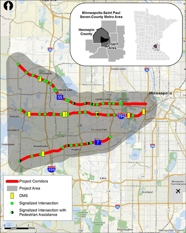
The MnFAST Initiative deploys CV applications along three corridors, TH 7, TH 55, and I-394, located west of downtown Minneapolis. The three corridors connect parts of Minneapolis and the western suburbs with downtown Minneapolis and other metro freeways.
The project area is located in areas of concentrated poverty, and areas of concentrated of poverty with 50 percent or more of residents being people of color. The corridors are relied on as a major transit corridor that links these populations to jobs centers throughout the Twin Cities. In addition, the study area is home to over 16,800 jobs. A large portion of these jobs (16%) fall within the manufacturing and distribution sector.
Today, there are thirty-nine direct transit routes along the three corridors. These transit lines are very important to those in the community who do not have access to a car to access jobs, public services, and post-secondary education. The project will help increase mobility for buses and increase their reliability to these destinations. More importantly, the improvements along the corridors will encourage active living and connect residents to jobs, services, and recreational opportunities.
Table 1 demonstrates each of the corridor's demographic data and comparison with Hennepin County and the seven-county metropolitan area. Key findings from this data indicate:
- The TH 7 corridor has a 14% smaller median household income than the 7-county metro and residents are more likely to be below 200% of the poverty line as well (31.3% vs 24.4%).
- The TH 55 corridor has the highest median household income of the three corridors but also has the highest percentage of underrepresented populations and people who speak a language other than English.
- The study area has a more diverse populace, has a lower median household income, and a greater percentage of residents who earn less than 200% of the poverty level than the 7-county metro.
- A third of the study area is spending more than 30% of its monthly gross income on housing, which is higher than the seven-county metro average.
- The proposed project will provide a wealth of improvements that will benefit a diverse community and those in poverty.
|
% of population with a disability1 |
Median Household Income 1 |
% of population below 200% of poverty level 1 |
||
|---|---|---|---|---|---|
I-394 Corridor |
24.6% |
10.8% |
$64,568 |
34.3% |
27.2% |
TH 7 Corridor |
27.8% |
10.3% |
$59,357 |
35.2% |
31.3% |
TH 55 Corridor |
37.2% |
11.3% |
$72,381 |
32.4% |
30.4% |
Project Area |
27.6% |
10.2% |
$67,075 |
33.4% |
27.7% |
7- County Metro |
25.2% |
9.4% |
$68,873 |
30.5% |
24.4% |
1 Source: Census Bureau 2011-2015 American Community Survey via Minnesota Compass
2 Note: Underrepresented populations are individuals who are any race other than non-Hispanic white.
3 Note: A cost burdened house is one that spends more than 30% of its monthly gross income on housing.
1.4 ISSUES AND CHALLENGES ADDRESSED
In seeking to deploy the most cost effective and beneficial connected vehicle (CV) applications, MnDOT conducted an extensive stakeholder outreach initiative, which gathered input from internal and external stakeholders. MnDOT solicited feedback regarding the greatest transportation needs, which focus on improving safety and mobility. The MnFAST Initiative proposed here will deploy CV applications which improve pedestrian and vehicle safety, improve mobility along signalized roadways, and reduce emissions. Table 2 below shows the four MnFAST application areas and corresponding USDOT connected vehicle applications from which components are included in this initiative.
|
MnFAST Application Areas |
||||
|---|---|---|---|---|---|
Traffic Flow Optimization |
Maintenance Vehicle Warning |
Transportation Information |
Pedestrian Assistance |
||
USDOT Connected Vehicle Applications |
Eco-Approach and Departure at Signalized |
|
|
|
|
Work Zone Warning |
|
|
|
|
|
Data Capture and |
|
|
|
|
|
Pedestrian in Signalized |
|
|
|
|
|
Enhanced Maintenance |
|
|
|
|
|
Fleet and Maintenance |
|
|
|
|
|
Integrated Corridor |
|
|
|
|
|
Road-Weather Connected |
|
|
|
|
|
Red Light Violation Warning |
|
|
|
|
|
Bus Stop Pedestrian |
|
|
|
|
|
1.4.1 Traffic Flow Optimization
1.4.1.1 SPaT
There are safety, traffic, and environmental issues that are addressed by providing SPaT data to travelers along the connected corridors. These three categories are discussed below. Details on how SPaT addresses these problems is discussed in Section 1.5.1.
Safety
Disregarding a traffic control device was a direct contributing factor in 32 fatal crashes and 1,602 injury crashes in Minnesota in 2015. When combined with in-vehicle or personal devices to relay information to drivers, SPaT data can be used to alert drivers to red-light conditions they may miss due to inattention or distraction. The use of SPaT transmission to vehicles has the potential to reduce fatalities and injuries by over six percent – even if no other DSRC applications are deployed.
Traffic
The corridors selected for the ATCMTD have high peak volumes and pronounced directional splits. Two of the three roadways in the corridor are signalized, with at-grade crossings. The existing signal systems are heavily optimized to maximize throughput, leaving little additional gain from further adjustments, given the data available. SPaT data can allow for speed harmonization and additional feedback on traffic movements, opening the possibility of additional capacity gains without constructing new roadway.
Environmental
The travel speed harmonization also reduces the acceleration/deceleration cycles of vehicles, allowing engines to operate at more constant speed with lower emissions. Improved "eco-driving" modes where engines can be shut down while at red lights are also possible. Engine starts produce relatively higher emissions than constant running, so avoiding unnecessary start-stop cycles (for example and automatic shutdown at 5 seconds, only to be restarted 1 second later) will also reduce total emissions in the corridor.
1.4.1.2 Traffic Data Collection
Since the broadcast of SPaT data will leverage DSRC technology, communication from the vehicle is also possible. Rather than a simple "presence" indicated by a loop or video-based detector, receiving the Basic Safety Message can provide a wealth of data including vehicle direction and speed. As a result, difficult to gather information such as turning movements can be gathered, and used to optimize "turn-only" indication and flashing yellow arrow implementations to minimize delay at intersections.
1.4.2 Maintenance Operations
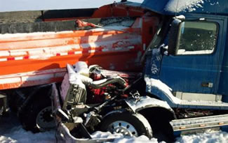
One of the most prevalent needs resulting from MnDOT's stakeholder outreach is the necessity to improve safety, including the reduction of crashes with maintenance vehicles. This includes snow plows and summer maintenance vehicles.
Maintenance vehicles are typically traveling at slower speeds or stopped along the roadway and in the case of snow and ice operations, visibility may be diminished leading to an increased safety risk. Each year, MnDOT experiences around a hundred crashes with its maintenance vehicles in the Metro District (see Table 3) and additional crashes in its construction work zones. MnDOT believes these safety problems can be reduced through the use of technology, such as providing warnings to drivers on DMS.
MnDOT has invested heavily in AVL and Maintenance Decision Support Systems (MDSS). Automating the flow of information to and from maintenance vehicles has provided MnDOT huge benefits, including improving the timeliness and quality of road condition information and chemical applications rates. These have, in turn, provided operators real-time recommendations and improved the overall efficiency and cost effectiveness of plowing operations.
|
Year |
Summer Maintenance |
Plowing and Sanding |
Total Crashes |
|---|---|---|---|
2013 |
61 |
45 |
106 |
2014 |
83 |
60 |
143 |
2015 |
75 |
15 |
90 |
1.4.3 Information Sharing
While the availability of real-time traveler information has certainly improved in the last decade, there are still many inefficiencies in the availability of data to travelers. In addition, data from different providers must be retrieved from multiple locations. Drivers can use the Mn511 website or mobile application to obtain MnDOT data, while relying on Google Maps or Waze for additional traffic data, incident data, and driving directions. An additional issue is the impreciseness or staleness of some of MnDOT's data, some of which are not published because they are too inaccurate. Through the deployment of new supporting infrastructure, such as DSRC radios and ATC controllers, MnDOT will have more precise and timelier data to make available to the public.
As MnDOT deploys the MnFAST Initiative applications, it will be gathering an even greater amount of data at greater frequency. By making its data freely available via a Transportation Information Data Hub, MnDOT will allow third-party developers to integrate the data into their applications. This improves the availability of data to users and reduces the application development costs MnDOT would incur by providing all new data sources through its Mn511 app.
1.4.4 Pedestrian Safety
Pedestrian-related crashes have recently reversed a long downward trend in Minnesota to return to their 2006 levels. After a decrease to 818 total crashes in 2014, the number jumped to 911 in 2015, with 41 of these crashes being fatal for the pedestrian. In fact, a pedestrian crash is five times more likely to be fatal than a single or multiple vehicle crash.
The majority of pedestrian-related crashes in Minnesota occur at signalized intersections where speed limits are 35 MPH or lower. The chief contributing factors for drivers involved in pedestrian crashes are Failure to Yield Right-of-Way (38%) and Driver Inattention or Distraction (20.5%). If drivers can be made more aware of pedestrian presence and can be alerted so that their attention is called to the crosswalk area, nearly 60% of crashes might be avoided.
Pedestrian behavior also contributes to crashes, with pedestrians crossing without a proper walk signal or excessive time taken to enter or traverse a crosswalk. Assisting pedestrians with requesting a "walk" signal, guiding them to the crosswalk and ensuring the "walk" indication remains active for the duration of their crossing has the potential to reduce an additional 24% of all accidents where these are contributing factors.
1.5 INCLUDED TRANSPORTATION SYSTEMS
MnDOT takes a comprehensive view toward Advanced Transportation and Congestion Management Technologies. Rather than focusing on a single mode, application, or stakeholder, our multi-faceted approach lays the foundation for next-generation technologies across the entire transportation spectrum.
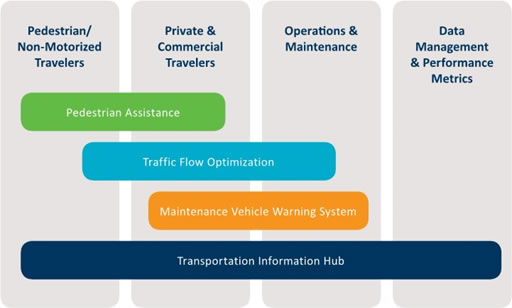
Four inter-related systems are envisioned to provide this foundation:
- Traffic Flow Optimization
- Maintenance Vehicle Warning
- Transportation Information Hub
- Pedestrian Assistance
These are described in detail in the following sections.
1.5.1 Traffic Flow Optimization
1.5.1.1 SPaT Broadcast
The value of Signal Phase and Timing information being provided to drivers has already been recognized by several automotive manufacturers who offer in-vehicle indications of signal status as optional features on their vehicles. A number of use cases for SPaT data have been identified through various research efforts. In 2011, the California Partners for Advanced Transportation Technology (PATH) outlined the following in a report entitled "Investigating the Potential Benefits of Broadcasted Signal Phase and Timing (SPaT) Data under IntelliDriveSM". These are some of the many SPaT use cases which could be implemented:
SPAT USE CASES
Safety
- Cooperative Intersection Collision Avoidance Systems (CICAS) – including traffic signal violation, left turn across path, opposite direction, traffic signal adaptation to extend all-red intervals to protect potential victims of red light runners and right-turn assistance.
- Display of real-time signal status information to driver (based on Japanese concept, like dynamic in-vehicle signage)
- Vulnerable road user warnings (pedestrians, bikes)
- Early alert of upcoming signal change to trucks with long stopping distances
Mobility
- Transit signal priority
- Truck priority for fuel savings (to minimize stops)
- Eco-driving support
- Advisory speeds to drivers to catch green waves
- Fuel-saving advisories to drivers (routing combined with real-time signal status data to minimize idling losses at signals
- Engine shut-off during stopped phases
- Corridor or area-wide signal timing optimization based on vehicle probe data (off-line and on- line)
- Allow users to avoid congestion by taking alternate routes, modes or departure times ("dynamic real-time routing")
- Provide better estimates of point-to-point travel times
- Automated vehicle location
- Improve predictability of transit trip times
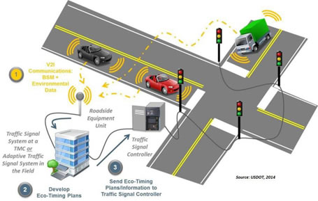
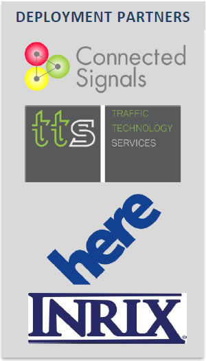
The enabling technology for SPaT broadcast is the DSRC interface at the cabinet or the use of cellular communications by partner organizations Traffic Technology Services (TTS) and Connected Signals. DSRC allows for high update frequency, low latency transmission of the SPaT data directly from the signal cabinet to the vehicle. These messages will be secured using a Public Key Infrastructure system currently in development by the USDOT.
To encourage SPaT implementation, the V2I Deployment Coalition has created the "SPaT Challenge". With the goal of having SPaT broadcasts available at a minimum of 20 intersections in each of the 50 states by 2020. For its first deployment, MnDOT will exceed this goal by deploying 74 DSRC radios to allow current SPaT to be extracted from the signal controllers and transmitted to vehicles in the local area. These units will also enable BSM data collection, as described in the following section.
The DSRC system enables programming functions that allow control over both the broadcast of SPaT data and writing it to an archive database for processing and distribution through the Transportation Information Data Hub, described in the following sections. To deliver a complete SPaT message, MAP/GID (Geographic Intersection Description) data will be added and included in the V2I broadcast.
To provide full SPaT functionality, the data will be sent to partner organizations, TTS and Connected Signals, that have developed algorithms and data interfaces specifically for this purpose. Their technology provides modeled timing information not directly available from controllers. Data will be distributed directly to individual travelers and sent in real-time back to MnDOT for distribution, free of charge, to the public. Drivers can receive the SPaT data via DSRC or over cellular connections on in-vehicle systems or smartphone applications. This approach maximizes the availability of data, and speeds the penetration of connected vehicle applications, which rely on network effects for maximum benefit.
1.5.1.2 BSM Collection
BSM messages are broadcast by DSRC On Board Units (OBUs) in each vehicle. The simplest BSM is the "heartbeat" message. The heartbeat includes the following attributes: Temporary ID, Time, Latitude, Longitude, Elevation, Speed, Heading, Acceleration, Brake System Status and Vehicle Size. These messages are broadcast ten times per second. NHTSA announced a Notice of Proposed Rulemaking in December 2016 to consider requiring this capability in all new vehicles. To enable reception of these messages and address the variety of issues described in section 1.4, MnDOT will leverage the SPaT-related DSRC deployments along TH 7, TH 55, and I- 394 and upgrade its controllers to the Advanced Transportation Controller (ATC) standard. DSRC is an established, standardized mechanism for low-latency, high-bandwidth communications with which MnDOT has been working as part of the IMO 3.0 initiative. The IMO effort installed DSRC roadside units equipped maintenance vehicles with onboard DSRC radios. The project also developed an interface between the AVL system and the in-vehicle DSRC radio to enable a cellular backup when DSRC communication is not available. The ATC controllers allow sophisticated programming to support the MnFAST Initiative applications and future connected vehicle deployments.
BSM data provides a rich source of information for not only real-time cooperative systems, but also for analysis and navigation applications. The system deployed for MnFAST will provide the communications infrastructure and data-handling mechanisms to turn large volumes of raw BSM data into valuable information for travelers and system managers alike.
The first step in BSM collection will be to deploy the needed DSRC radio hardware. Since DSRC does not yet have wide consumer penetration, the radios will be installed in signal cabinets along roadways serviced by MnDOT maintenance vehicles. This maintenance fleet will be equipped with DSRC OBUs as part of the Maintenance Vehicle Warning System described in the following section.
Data will be transferred from the cabinets via the 10-gigabit fiber optic network already in place connecting the cabinets. However, a robust, high-performance data management platform will be needed to ingest and process the data. While the initial deployment will involve the maintenance fleet and select roadway corridors, the goal is to develop the tools that could scale to handle messages at thousands of reception points from millions of vehicles broadcasting ten times per second. The data management platform will follow MnDOT's practice of making software tools open whenever possible to ensure that other agencies can benefit from their development work.
"Raw" BSM data becomes more valuable when aggregated and summarized. Processing makes it both a usable product and enhances the privacy of the traveling public by making individuals impossible to identify. A variety of aggregation operations will be possible in the data management platform. One of the most useful will be a "binned" summarization of vehicle speeds at an intersection over a selected interval. Ideal intervals will be determined by the volume of data available and the desired granularity of speed data. For example, a one-minute bin may contain too few data points for aggregation to be statistically meaningful. This project will establish the parameters of aggregation and the appropriate techniques.
Once properly summarized, the BSM data will be published through the Transportation Information Data Hub described in section 1.5.3. The Hub enables any interested user to access the data as it is updated for whatever applications they wish to create.
Initially, INRIX and HERE will extract data from the Hub and blend it with their other data sources, such as probe vehicles and fleet GPS data. BSM data has desirable characteristics as it will eventually represent a large cross section of vehicles. Current samples (such as commercial fleet data) may be biased toward vehicles with very different dynamic characteristics than a typical passenger vehicle. By building the infrastructure to capture large volumes of vehicle data and providing it to traffic data providers directly benefits the traveling public through more widely available, more accurate and more representative traffic information.
The archiving of aggregated BSM data will also allow for analysis of typically difficult to monitor traffic characteristics, such as turning movements and wait times at traffic signals. These aspects of traffic mobility typically require limited observation/recording periods followed by lengthy and expensive hand-coding periods. For the first time, a continuous observation of traffic dynamics at traffic signals will be possible, allowing advances in signal timing optimization that result in shorter wait times, lower emissions and shorter overall trip times.
1.5.2 Maintenance Vehicle Warning System
During the Work Zone Accident Reduction Deployment (WZARD), MnDOT deployed ITS and CV applications allowing for real- time traffic management and traveler information to be delivered along the I-94 corridor via DMS. The primary goal of the project was to help avoid car-truck collisions or crashes due to evasive maneuvers in the vicinity of MnDOT maintenance vehicles. The project focused on the integration of various field devices to provide I-94 travelers with real time maintenance operations status and traveler information using DMS. A primary feature is the warning displayed on DMS to alert motorists that a maintenance or construction vehicle is operating downstream.
As part of this project, MnDOT will modify and deploy this maintenance vehicle warning system on TH 55, TH 7, and I-394 using DSRC. Figure 6 and Figure 7 show DSRC communication between the maintenance vehicle and DMS. MnDOT will be able to expand this system to other corridors equipped with DMS as more maintenance vehicles are equipped with DSRC.
Similarly, as DSRC is integrated into passenger vehicles, drivers will receive the maintenance vehicle warning directly in the vehicle cab, expanding the system even more and improving its effectiveness. Snow plows equipped with DSRC will provide a warning to motorists during plowing operations. These same vehicles can provide warnings to travelers during summer road maintenance activities.
Additional maintenance vehicles will also be equipped with DSRC to ensure drivers are warned of short-term and moving work zones along highs-speed roadways, helping reduce end-of-queue crashes and crashes with these maintenance vehicles. This warning system could be incorporated into long-term construction zones, reducing end-of-queue crashes approaching work zones and crashes within work zones. These are both major safety problems for MnDOT and other DOTs, as demonstrated in a recent work zone crash on TH 77 in Minneapolis, in which the vehicle occupants were critically injured.
1.5.3 Transportation Information Data Hub
The advent of the connected vehicle environment has raised the prospect of enormous volumes of data becoming available, both to system stewards and the traveling public. However, without a well- documented, centralized interface to the data, it will be difficult for third party developers to create innovative applications to make use of it. 511 smartphone applications provide access to a subset of data but independent developers are well suited to process data sets and create tools to access the data. A standardized and well-documented Transportation Information Data Hub simplifies access to data and encourages a wider variety of uses. Enabling public access to this store of data will bring both a richer field of applications and allow public agencies, such as MnDOT, to reduce the resources they commit to developing applications of their own.
In addition, the prospect of receiving data from a DSRC-equipped vehicle fleet requires data management tools capable of handling very large numbers of records to be stored and processed. When DSRC reaches appreciable levels of fleet penetration, BSM capture using just the 74 planned intersections could reach 100 billion records per day. While the need to process volumes of data that large is years in the future, developing the tools and data structures to accommodate it now is needed to plan for making data products available.
MnDOT proposes to consolidate data produced by existing transportation systems, as well as the deployments envisioned by the state, into a newly developed information management system. This information management system will process the incoming data to screen out any sensitive elements and provide an interface to a "public facing" data hub.
Enabling the processing of large volumes of data into usable products, MnDOT will use tools designed for "big data" applications. A "stack" of applications providing distributed database storage, data reduction and extract-transform-load (ETL) operations will be deployed to create the foundation for managing very large volumes of vehicle data – hundreds of billions to trillions of records if needed.
The first step includes assessing the available attributes from all the available transportation systems. From this assessment, the data structure for the information processing system will be created and the physical infrastructure deployed. Next, MnDOT will identify the attributes to be made available, the valid value and formats that will be published, and create the Transportation data Information Hub and documentation for third party developers. The data management stack will be selected on the characteristics both of the incoming transportation data and the desired products that will be made available to the public. Finally, the data hub will be deployed, allowing access to application developers and the public. A schematic diagram showing the Transportation Information Data Hub system concept is shown in Figure 9. Developing a publicly available data hub allows MnDOT to deliver more information to the public at a lower cost, encourages growth of third-party mobile transportation apps, and decreases the difficulty of obtaining real-time transportation related data. These benefits, combined with the more precise and timely data obtained from the new supporting ITS infrastructure, will provide a significant improvement in the traveler information available to Minnesotans.
1.5.4 Pedestrian Assistance
Transportation infrastructure investments have typically focused on motorized vehicles, whether private automobiles, commercial vehicles or transit. MnDOT recognizes the importance of pedestrian- scale development and walkable, "livable" communities.
To advance the goal of access by all travelers in all modes to workplaces and services, three separate pedestrian-related elements will be implemented as part of the ATCMTD. These include innovative technological approaches developed in Minnesota and elsewhere to represent the leading edge in pedestrian assistance.
The graphic below illustrates the overlapping systems used to improve the safety and efficiency of pedestrian movements:
- Pedestrian Guidance – Specific aids for vision-impaired pedestrians.
- In-Vehicle Pedestrian Warning – General warning applications for both vehicle dashboard and personal devices
- Dynamic Pedestrian Clearance Interval – Detection and signal controller applications that extend the flashing don't walk interval as needed to facilitate safer crossings.
Each of these application is described in detail in the following sections.
1.5.4.1 Pedestrian Guidance
In 2012, the University of Minnesota created a system to enhance the safety and accessibility pedestrian crossings for vision-impaired pedestrians. The Mobile Accessible Pedestrian Signals (MAPS) system. This novel application used a simple interface to the local signal controller and wireless communications to send pedestrian crossing status to a cellphone application. Combined with advanced mapping, the application will provide pedestrians with directional information for the crossing. Text-to-speech technology ensure that messages were available regardless of vision impairment.
In addition, pedestrians can use the application to wirelessly request a pedestrian crossing "call" without having to search for the location of a hard-wired call button. Figures 11 and 12 illustrate the system operation. A single tap on the smartphone interface will provide information about the crossing. A double-tap on the application will provide information on the "walk" time remaining and, depending on orientation, make a request for a pedestrian crossing.
An extensive research project validated the usefulness of the MAPS system. Time savings were substantial, with the in-position time (time from passing a pushbutton pole to waiting at the beginning of crosswalk) was reduced from an average of 38.4 second for a standard pushbutton to 9.8 seconds with MAPS.
Surveys of a test sample of vision-impaired pedestrians further validated the usefulness of MAPS. MAPS was preferred by nearly a 3 to 1 margin over a standard pushbutton. Those stating the MAPS provided useful information about intersection geometry outnumber those who didn't by a 5 to 1 margin.
This impressive technology has been developed further to include information about temporary crosswalk obstructions to work zones and designs are in place to enable project managers to easily input data about changing conditions from the job site with a smartphone application.
The MAPS system or similar application will be deployed at intersections that experience crossing issues and will improve the safety of pedestrians and the efficiency of vehicle traffic due to the shorter (approximately 2 seconds) times taken between a walk signal and entering the crosswalk.
1.5.4.2 In-Vehicle Pedestrian Warning
Distracted driving is an increasing concern in transportation safety. In 2015 alone, 3,447 deaths were directly attributable to distracted driving. Pedestrian-related crashes number over 70,000 per year. While the National Highway Traffic Safety Administration encourages a number of approaches involving education and advocacy to reduce distracted driving, more direct options are also available.
In-vehicle warnings of pedestrian presence can help reduce vehicle-pedestrian crashes. Vehicle sensor systems provide one mechanism, but novel systems integrated with DSRC hardware at intersections enable in-vehicle warning for vehicles that lack sophisticated sensors that can detect pedestrians.
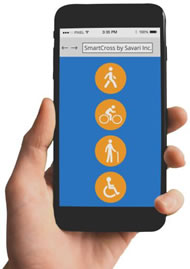
The USDOT SmartCross smartphone application is the basis for enabling a suite of pedestrian-infrastructure services. When used in combination with an in-cabinet device pedestrians can be located if in the crosswalk, and a signal broadcast over the DSRC communications link to vehicles in the area. This signal can then activate an in-vehicle warning (without any driver intersection), increasing the probability that a driver will know a pedestrian is present and providing additional reaction time.
The functionality can also be extended to provide wireless crossing request buttons, similar to the MAPS system, but without an interface optimized for vision-impaired users. This system will be enabled by the SPaT and Maintenance vehicle deployments listed above. Both the hardware needed to communicate from the traffic signal to the pedestrian and in-vehicle hardware capable of receiving a warning message via DSRC will be installed as part of the project. Several intersections will be equipped with the needed equipment, offering an opportunity to improve both the safety of pedestrian travel and the overall quality of life for walkable-scale communities.
1.5.4.3 Dynamic Pedestrian Crossing Interval
As a part of MnDOT's Innovative Ideas program, a system that can dynamically increase the length of the pedestrian clearance interval based on crosswalk occupancy is currently in development.
In 2011, the Minnesota Manual on Uniform Traffic Control Devices (MnMUTCD) was updated to include guidance that the pedestrian clearance interval, Flashing Don't Walk Time (FDW), for traffic signal timing purposes should be calculated using a 3.5 ft./sec. pedestrian walking speed. This was a change from the previous guidance of 4.0 ft./sec.
Despite the change to the slower recommended walking speed of 3.5 ft./sec., some pedestrians (especially those with special needs), may still not be fully accommodated. Availability of even longer pedestrian clearance intervals will increase safety for these users. A pedestrian moving at 3.0 ft./sec. who leaves the curb just as the Flashing Don't Walk light comes on will not be able to reach the far curb by the end of the FDW interval under such timings.
To address this safety concern, detecting the presence of pedestrians in the crosswalk and dynamically altering the length of the flashing don't walk signal being deployed.
Accurate pedestrian detection is critical for such a system, and Minnesota-based Image Sensing Systems has developed an algorithm using a video-based pedestrian detection sensor. This device achieves high accuracy through stereo vision and an integrated 3D image video analytics engine. It is able to detect objects in the sensor's field of view while ignoring confusing artifacts such as shadows, reflections, water, snow, or any other debris on the ground. It is designed to integrate seamlessly into existing installations with a simple interface to intersection controllers. Pedestrian detection accuracy will be further enhanced through the use of multiple detectors for each crosswalk, providing a factor of safety via redundancy.
Dynamic Crossing hardware will be installed at nine intersections, providing a variety of traffic and pedestrian conditions. The existing operational test project will be leveraged to provide both guidance for system installations and a structure for evaluation of system performance.
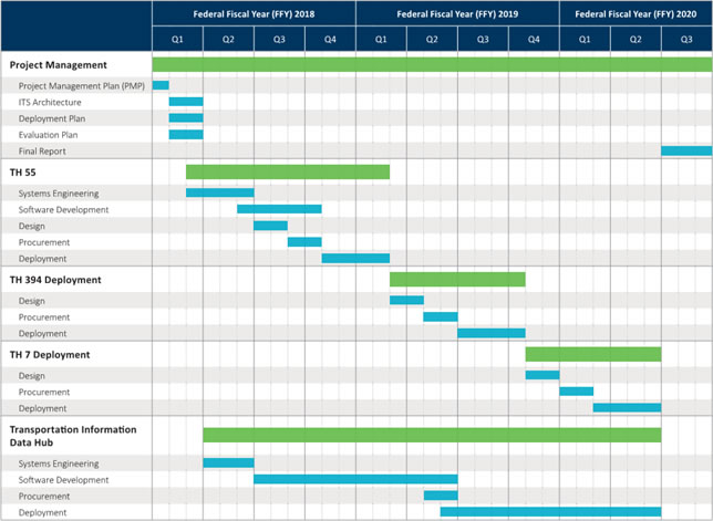
1.6 DEPLOYMENT PLAN
With a history of providing one of the best road transportation systems in the country, in spite of the extensive snow and ice and roadway maintenance required due to the climate, MnDOT is prepared to provide long-term operations and maintenance on the new hardware, software, and applications deployed in the MnFAST Initiative. MnDOT already supports large scale, complex ITS deployments and its plan includes a schedule for regular maintenance on all devices deployed, regular updates to software, and contingency plans for unforeseen circumstances. MnDOT has ensured that departments responsible for ongoing maintenance will have adequate resources available after deployment to keep the MnFAST applications up and running. Most of the devices utilized in this initiative are already supported by MnDOT and the upgrading of its controllers will actually lead to a more maintainable system, with more reliable parts, consistency across devices, and remote upgrades possible. However, additional resources will be made available to support the implementation of new technologies.
In addition, MnDOT will remain flexible in its approach to deploying advanced technologies. While the National Highway Traffic Safety Administration (NHTSA) proposed mandate would require DSRC in light-duty vehicles, MnDOT understands that technologies evolve quickly and federal mandates may change. MnDOT will, therefore, be prepared to adapt its deployments as changes in the industry occur, such as a shift toward newer cellular technologies such as 5G.
MnDOT will utilize a phased deployment approach to ensure it remains on schedule and on budget. Deployments will begin by prototyping the applications on TH 55 in year one. Limiting the deployments initially will allow MnDOT to work through integration challenges more easily. After successful deployments on TH 55, year two will focus on I-394, and finally year three on TH 7. MnDOT will begin development of the Transportation Information Data Hub in year one, with integration and testing in years two and three. With MnDOT's Connected Corridor project beginning several months earlier, MnDOT will have developed a concept of operations, requirements, and a network security plan about many of the same technologies deployed in this MnFAST Initiative. This parallel effort will help to keep the MnFAST Initiative on schedule and on budget.
1.7 REGULATORY OR INSTITUTIONAL CHALLENGES AND OBSTACLES
MnDOT has enjoyed productive and cooperative relationships with both the state legislature and other transportation system stewards in the region for many years. The services proposed are complimentary to existing functions for all of the potential agencies involved and no regulatory or legislative obstacles are anticipated that cannot be addressed within the context of the project.
MnDOT:
The proposed applications cross disciplinary lines within MnDOT and will require coordination between different departments. The design group of the Regional Transportation Management Center will be responsible for DSRC deployment, but many of the applications will involve the operations group, responsible for traffic signal operations and management. While these groups have different internal structures and responsibilities, they have a long history of cooperation and interaction, and no obstacles to project progress are anticipated.
Between MnDOT and other Government Agencies:
All deployments will be on MnDOT-controlled roadways, but may affect traffic flows on adjacent or intersecting roadways operated by cities or counties. MnDOT currently operates traffic signals on freeway exit ramps and along major arterial corridors. Both of these intersect with non-MnDOT roadways, and agreement structures have been in place for decades to manage these relationships. No issues related to inter-governmental agreements are anticipated.
1.8 PERFORMANCE IMPROVEMENTS
MnDOT uses performance criteria to guide capital investments and annual operational budgets. Transportation system and agency performance reports are regularly reviewed by MnDOT management. Applying the FHWA Objectives-Driven, Performance-Based Approach, enables MnDOT to track system-wide performance, identify specific deficiencies and needs, as well as, identify, develop, and assess strategies to achieve optimal results. With a collaborative effort, their approach increases transparency and encourages innovation by keeping the focus on outcomes to support improved system performance and enhance performance-based management.
This project proposes several concepts which offer measurable impacts, including improved safety, mobility, and environmental benefits. The careful application of technologies that serve multiple purposes will improve operations, reduce maintenance costs, and allow for greater future flexibility for additional deployments.
Examples of the safety, mobility, operational, and environmental quantifiable system performance improvements provided by the MnFAST Initiative applications are summarized below.
Traffic Flow Optimization
- Fewer end-of-queue crashes
- Reduced motorist delay/Increased throughput
- Reduced emissions
Transportation Information Sharing Hub
- Improved quality and accessibility to traveler information
- Reduced ongoing application development costs
- More informative and reliable travel information applications
Maintenance Vehicle Warning System
- Fewer crashes with maintenance vehicles
- Fewer end-of-queue crashes
- Improved traffic flow with fewer shockwaves
Pedestrian Assistance
- Greater pedestrian accessibility
- Improved pedestrian safety
- Connect residents to jobs and services
- Benefit a diverse community and those in poverty
1.9 BENEFIT PROJECTIONS
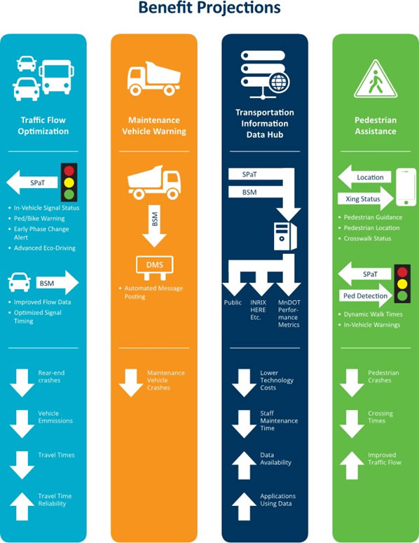
The benefits provided by the broad-based approach taken by MnDOT will span all roadway modes and reach the traveling public, operations and maintenance staffs, and private data and application providers. Each of the applications envisioned under this grant and the benefits expected from them are summarized in the following graphic.
Once operational, MnDOT will conduct a detailed evaluation of each deployment, comparing post-deployment performance measures to the baseline to evaluate its effectiveness. By employing an independent evaluator the data necessary for a thorough and accurate evaluation will be collected, analyzed and reported. Results of the evaluations will be shared with the USDOT in a format agreed upon during system design.
It is anticipated that many of the performance measurements will reflect the focus of the particular deployment. Measures may include:
- Pedestrian crashes and conflict movements at unequipped signalized intersections vs equipped intersections
- Crashes with equipped vs unequipped maintenance vehicles
- Conflicting movements (near misses) with maintenance vehicles
- Maintenance vehicle message activations and activation reliability
- SPaT and BSM data accesses (from Data Hub)
Other measures will be determined to conform to the specific systems engineering Concepts of Operation developed for each deployment.
The traveling public, particularly those with mobility or vision impairment will experience direct benefits from the system once deployed. The completely automated nature of the Dynamic Pedestrian Crossing Interval will provide immediate benefits that can be measures using the methodology from the prototype MnDOT Innovative Ideas system. The Metro Transit ATCMTD application also has benefits for transit riders. Specifically benefits to persons with visible and hidden disabilities and elderly population. But, the benefits of universal design flow to all riders, through better information integration and individualized solutions to travel. Other aspects will require a survey approach to gauge value to the user, as in the University of Minnesota MAPS study. The improvements in traffic flow will directly benefit the disadvantaged populations in the corridor as many travel to the high-density Minneapolis CBD at the terminus of the corridor.
Connected vehicle technology is in its infancy. As the infrastructure for exchanging and managing connected data matures, these projects will serve as the foundation for a universe of applications with an expanding sphere of benefits for travelers, system managers and private industry alike. Future applications using MnFAST as a base include:
- Bus Rapid Transit (BRT) and fixed route transit prioritization at traffic signals
- Active crash avoidance
- Road condition warning
- Queue warning
- Smart City data integration
- Advanced travel routing to minimize travel times and emissions
All of these applications require robust data collection, networking and management tools as enabling technologies. The focus of MnFAST is to provide a solid, maintainable foundation so these may be realized.
1.10 VISION, GOALS AND OBJECTIVES
MnDOT's Vision for the ATCMTD is simple: Lay the foundation for connected applications across all ground modes and disciplines in transportation.
Our approach sets out the following goals:
- Enhance safety for all modes using the roadways
- Improve mobility, including non-motorized
- Leverage the existing robust networks to facilitate data movement
- Provide benefits to the traveling public, system stewards, and transportation application providers
- Simplify and expand access to data
This comprehensive approach begins with the objective of deploying and proving a number of technologies with the intent of introducing on a wider level. The experience gained from the ATCMTD projects will inform decisions on wide area network infrastructure, signal integration, data processing and a host of other integration targets needed for consistent, reliable roll-outs of connected vehicle applications in the future.
1.11 PARTNERING PLANS
MnDOT has a long history of partnering with both public and private entities to speed deployments, maximize the benefits, and gain favorable returns on investment for all parties involved. Over 20 years ago, MnDOT was a pioneer in public-private partnerships which brought together State, county and city agencies with both large and small private businesses to provide multimodal solutions to the public while providing incentives for private industry to invest in the field. This history will be carried forward and adapted to the 21st century transportation environment.
To provide a full, predictive SPaT message (one that includes and accurate countdown to the next red or green phase), MnDOT will leverage the technology developed by firms such as Connected Signals and TTS. These innovators have created algorithms that take real-time data on the state of a signal and use the associated timing plan to accurately model the timing of upcoming phases. Partnering with these firms to provide access to the real-time and timing plan information in exchange for a feed of processed SPaT data will enable MnDOT to provide a publicly accessible, real-time SPaT feed for any application purpose.

In addition, companies such as INRIX and HERE can now ingest processed BSM data to improve the quality of their probe-based traffic data. The inclusion of speed data from DSRC-equipped intersections enhances the accuracy of traffic flow data. Routing can also be dramatically improved for travelers on local roads. For the first time, travelers using navigation applications can be provided with accurate travel times for signalized roadways.
Partnering with these firms will be cost-neutral for the project. No net increase in costs or funding needs will be incurred as a result their involvement. Letters of support can be found in the appendix.
MnDOT also has several institutional partners with whom it has strong working relationships. The Minnesota Guidestar, University of Minnesota, and Metro Transit are involved in
many of MnDOT's projects whether directly or indirectly through support and guidance roles. These partners will continue to play an important role as it deploys the MnFAST Initiative and other advanced CV applications.
Metro Transit has plans for CV deployments, including within the MnFAST Initiative project area. MnDOT and Metro Transit will work together to capitalize on each other's CV deployments. For example, Metro Transit buses installed with DSRC radios will be able to receive SPaT information from MnDOT and broadcast BSM messages which MnDOT can receive. In addition, Metro Transit's application for ATCMTD will seamlessly integrate advanced technologies into the generally routine functions associated with transit ridership, thereby reducing obstacles to public transportation, increasing confidence, and increasing access to opportunity. The two agencies will continue to look for opportunities to partner as they deploy CV technology
1.12 EXISTING SYSTEMS LEVERAGED
MnDOT's forward looking vision and investments in technology on its roadways puts the agency in an ideal position to support the deployment of this initiative.
MnDOT has been a leader in developing, deploying, operating, and maintaining ITS technologies. With its extensive network of CCTV, ramp meters, detectors, and DMS all connected back to the Regional Transportation Management Center (RTMC) via a state-owned, operated, and maintained 10-gigabit fiber optic network, MnDOT is perfectly positioned to deploy CV technology. In recent years, MnDOT has extended its fiber optic network to much of the arterial State Trunk Highway network as well, and will continue to build upon this network to connect all traffic signal controllers to the RTMC via fiber by 2019. By leveraging the existing fiber optic communications and ITS sites, MnDOT is able to deploy CV technology a much more cost effective manner. The MnFAST Initiative will set the stage for connected vehicle technology deployments.
In addition, MnDOT's past experience testing DSRC and deploying complex ITS applications will be extremely advantageous as it deploys the MnFAST applications outlined earlier.
MnDOT has worked with roadside and onboard DSRC units, testing the transmission of data from its AVL system on maintenance vehicles to roadside DSRC units which are connected to MnDOT's extensive fiber optic network. MnDOT has also tested the optimal placement of DSRC radios to maximize range and the use of the existing cellular communications as a backup when DSRC is not available.
In addition to leveraging its existing infrastructure, MnDOT will fully utilize its MnFAST deployments in future CV projects. Some examples discussed by MnDOT and other stakeholders which could leverage its investments in DSRC and other CV technology are listed below. MnDOT will continue to explore these possibilities as it looks to maximize its investments.
Future MnDOT Connected Vehicle Projects Leveraging MnFAST Deployments
- Transit Priority
- Mobile Road Weather Sensors on Fleet Vehicles
- High Density RWIS Networks
- Additional Pedestrian Assistance Applications – in conjunction with Metro Transit. Equip a number of C & D Line buses with detection/warning technology and DSRC radio Pilot intersection – 7th Street North & TH 55.
- Curve Speed Warnings
- Oversize Vehicle Warning
- Railroad Crossing Warning
- Railroad Grade Crossing w/ Signal Interconnect – Advance Preemption
- Traffic Signals – Phase Termination (Red Light Warning)
- Work Zone Safety – Workers Present Warning, Speed Warning, Upcoming Work Zone Warning
- Rural Intersection Collision Warning System
1.13 SCHEDULE
The MnFAST Initiative is planned over three years. MnDOT has, however, already begun preparing for the project through planning, systems engineering, stakeholder outreach, and parallel project work (Connected Corridor project). With project kickoff just four weeks after contract award, this initial work will prove critical in allowing MnDOT to begin scaling up the deployment immediately and propel the project through a busy first year.
As discussed in the deployment plan, MnDOT will utilize a phased deployment approach to ensure it remains on schedule and budget. MnDOT will first deploy prototypes of each application on TH 55 during the first year. In year two, the focus will shift to I-394, with deployments on TH 7 occurring in year three. Development of the Transportation Information Data Hub will begin immediately in year one, with integration and testing occurring in years two and three.
MnFAST Initiative Program Manager Cory Johnson will work closely with the USDOT/FHWA Project Manager to manage all aspects of the project including scope and schedule. This includes performing the necessary coordination to ensure all potential issues and risks are addressed in a timely manner, keeping the project on schedule.
1.14 ITS PROGRAM INITIATIVES LEVERAGED
MnDOT takes a comprehensive approach to re-use and integration of existing transportation investments. Connected Vehicles will leverage a number of existing initiatives to provide rapid deployments and reliable operations.
The suite of services described in Section 1.5 provides a comprehensive approach to addressing each of the goals described in the USDOT's ITS Strategic Plan and other initiatives, such as the Smart City Challenge and V2I Deployment Coalition.
- Distribution of SPaT data and BSM Collection represent natural extensions of MnDOT's aggressive traffic management program. The deployments will occur on signalized corridors serving the Minneapolis central business district, which has large volumes of heavy traffic. Given the significance of these corridors, MnDOT has invested in very robust networks capable of moving large volumes of data, video surveillance, vehicle detection and modern signal controllers. All of these investments compliment the SPaT and BSM portions of the project.
- The Maintenance Vehicle Warning System utilizes DSRC to enable V2I communication between maintenance vehicles and roadside signs, leveraging the emerging communication technology to provide real-time safety enhancements.
- The wealth of information already collected by MnDOT will be substantially augmented by the deployments described in this proposal. Making that data easily accessible to all potential users will be enabled by the Transportation Data Information Hub. By defining a clear, easy to use access mechanism, development of novel applications by the private sector will be encouraged, and a model for standardization of interfaces to transportation data will be created.
- Non-motorized modes are a strategic focus in Minnesota. Minneapolis is ranked as the #1 most bikeable city in the nation, and the #9 most walkable by Walk Score. Development and deployment of pedestrian and bicycle detection has a long history with such projects as the Midtown Greenway and its associated urban trails. The Pedestrian Assistance elements of the deployments extend existing efforts by employing connected technologies (DSRC and others) and integrating pedestrian movements into signal operations
The ITS 2015-2019 ITS Strategic Plan from the U.S. Department of Transportation Joint Program Office (JPO) outlines specific program goals in six areas. These are:
- Connected Vehicles – Integration with legacy systems, benefit/cost lessons and local agency deployments.
- Automation – Define core elements and performance criteria, test concepts and define the Federal role.
- Emerging Capabilities – Use technologies for real-time needs, meet public policy objectives and integrate new technologies.
- Enterprise Data - Integrate new data sets, identify data management models and enable new business relationships.
- Interoperability – Follow the National ITS Architecture, inventory interfaces for standardization, harmonize standards and facilitate the testing and certification process.
- Accelerating Deployment – Define mechanisms to encourage public and private investment, develop analytic tools and establish tools to support the new user base.
A summary of how each of the proposed applications relate to the ITS Strategic Plan is shown below.
|
Connected Vehicles |
Automation |
Emerging Capabilities |
Enterprise Data |
Interoperability |
Accelerating Deployment |
|---|---|---|---|---|---|---|
Traffic Flow Optimization |
|
|
|
|
|
|
Maintenance Vehicle Warning |
|
|
|
|
|
|
Transportation Information Data |
|
|
|
|
|
|
Pedestrian Assistance |
|
|
|
|
|
|