Advanced Transportation and Congestion Management Technologies (AID) Deployment Initiative (ATCMTD): Maine Department of Transportation
Project Narrative
Maryland Advanced Technology Infrastructure Deployment (ATID) - Project Overview
Accommodating the growing capacity needs of Maryland's road users and increased levels of
peak-hour congestion with financial and right-of-way constraints necessitates creative thinking for better Transportation Systems Management and Operations (TSM&O) strategies. As a result, the Maryland Department of Transportation State Highway Administration (MDOT SHA) has identified locations suitable for Advanced Technology Infrastructure Deployments (ATID), one of which is the I-95 corridor that connects the Baltimore and Washington D.C. metropolitan areas. Affordable and scalable transportation solutions with high benefit-to-cost ratios are needed to provide safe, efficient and reliable travel choices to Maryland's customers. Accordingly, MDOT SHA is proposing the concept of an ATID deployment that will achieve significant TSM&O benefits through implementation on freeway, arterial, and transit networks, but with new technologies that require less risk and investment. To achieve these goals, MDOT SHA intends to:
- Deploy a robust and reliable Intelligent Transportation Systems (ITS) communications network to sustain the deployment of devices to support the proposed ATID implementation and connected and autonomous vehicle functions.
- Deploy the most current and affordable advanced roadway monitoring, detection and traffic control technologies along critical routes (i.e. US 1) adjacent to the I-95 corridor to influence travel choices and provide multi-modal options through improved traveler information and guidance.
- Launch, as part of this ATID project, a connected vehicle deployment along the US 1 corridor from MD 32 (to the south) to I-195 (to the north) that will test a wide range of Dedicated Short Range Communication (DSRC) and traffic control technologies in an effort to meet the American Association of State Highway and Transportation Officials (AASHTO's) Signal Phase and Timing (SPaT) Challenge.
- Leverage lower-cost, real-time connected vehicle data streams that will be readily available through Vehicle-to-Infrastructure (V2I) systems to provide opportunities for improved TSM&O along the study corridor.
MDOT SHA TSM&O - Broader Vision and Goals
MDOT SHA adopted a TSM&O Strategic Implementation Plan in August 2016. The Maryland
TSM&O Plan provides an integrated approach to programmatic optimization of planning, operations, and maintenance in implementing new and existing multi-modal systems, services, and projects to preserve capacity and improve the security, safety, and reliability of our transportation system. As shown in Appendix C, the Maryland TSM&O Strategic Implementation Plan identifies goals, objectives, strategies, performance measures and action items to advance the mission and vision of the agency. With oversight from the MDOT SHA TSM&O Executive and Steering Committees, various TSM&O implementation efforts are underway, including streamlining business processes, to aid in the development of an Integrated Freeway and Arterial Master Plan. Advanced technology infrastructure deployment is a core strategy to advance the Maryland TSM&O Program.
The broader vision and goal of the proposed ATID project is to make the Maryland transportation network more safe, efficient and reliable for commuters, businesses and freight shippers through advanced technology deployments. Our project will support the core of the official ATCMTD program visions and goals. This is further supported in Appendix A.
MDOT SHA Motivation for Maryland ATID Project
Over the last three decades, MDOT SHA's Coordinated Highways Action Response Team
(CHART) program has served its core mission to improve "real-time" operations of Maryland's highway system through teamwork and technology. MDOT SHA has demonstrated its commitment to the CHART program by building the CHART Advanced Transportation Management System (ATMS), developing institutional arrangements and investing in the University of Maryland (UMD)-led Regional Integrated Transportation Information Systems (RITIS) platform. Moreover, there is a broader leadership commitment in advancing the mission of the agency through technology and innovations. Maryland is considered an industry leader when it comes to its Incident Management and Travel Advisory capabilities. The agency is committed to building functional and operational capacity with its CHART and signal system programs to advance Active Traffic Management (ATM) and Integrated Corridor Management (ICM) strategies. MDOT SHA realizes the importance of technology infrastructure deployments on the transportation network and the ATMS. And, with the recent advancements made in the Connected and Autonomous Vehicle (CAV) arena, associated Vehicle-to-Vehicle (V2V), V2I, and high-definition SPaT advancements, getting our technology infrastructure ready for current and upcoming operational protocols is critical. As described in the "Ongoing Efforts" section, MDOT SHA is developing the US 1 corridor from MD 32 to I-195 in Howard County as a location for newer/innovative technology readiness assessments, protocol development, deployment, and testing. There is also an MDOT SHA funded project underway on the I-95 corridor that proposes Active Traffic Management (ATM) solutions parallel to the proposed US 1 testbed with similar corridor limits. The I-95 Planning Study is specifically focused on developing solutions involving dynamic shoulder operations. Considering this as a foundation, the Maryland ATID project aims to build on MDOT SHA's ongoing/upcoming technology infrastructure deployment efforts. As described in the "Deployment Plan" section, the ATCMTD grant would enable MDOT SHA to broaden the scope of these initiatives along the I-95 and US 1 corridors, as well as critical intersecting roadways as a system to evaluate current and future TSM&O and CAV strategies. The Maryland ATID project also provides MDOT SHA with an opportunity to participate in the AASHTO SPaT Challenge.
The MDOT SHA TSM&O Plan recognizes that effective deployments will alter future needs in ways that planning staff must fully comprehend and support. The SHA's Office of Planning and Preliminary Engineering (OPPE) has now been integrated into all proposals and project development phases, and later during all evaluation phases. This project will be jointly administered by the MDOT SHA's Office of CHART, Office of Traffic and Safety (OOTS), and OPPE, with CHART serving as the lead office. As the lead contracting agency, MDOT SHA will exercise financial control through existing subcontracting relationships with the team members listed in the "Partnering Plan" section.
Integrated Freeway-Arterial Operations
Managing recurring and non-recurring congestion is one of the greatest challenges associated with a State DOT's TSM&O efforts. Peak hour congestion, incidents, construction, weather and special events can all affect the efficiency and reliability of the transportation network. When one, or a combination, of these conditions causes a breakdown of reliable/comfortable travel on a freeway, diversion of traffic volumes to an adjacent arterial roadway is often the most obvious option for the Traffic Management Center (TMC), until issues preventing mobility on the freeway can be resolved through various methods. Under these circumstances, integrated freeway-arterial operations are critical to maintain mobility.
MDOT SHA understands the importance of integrated freeway-arterial operations and has been looking into candidate locations for deployment. As part of this ATID project, SHA intends to incorporate freeway-arterial operations deployments to support the various committed initiatives (I-95 ATM Project, ITS Infrastructure Deployment, etc.) further discussed in the "Ongoing Efforts" section below. However, the funding obtained through this grant opportunity will be used to, specifically, implement ATID to support the previously mentioned "US 1 Innovative Technology Deployment Corridor Project," which is also discussed in more detail within the "Ongoing Efforts" section.
The Baltimore-Washington Corridor – Challenges and Opportunities
Maryland has an ideal proving ground for demonstrating the value of advanced technology deployment in the transportation infrastructure connecting the Capital (I-495) and Baltimore (I-695) Beltways in the Baltimore-Washington (B-W) region. This network is a critical part of the broader transportation network that connects the Baltimore and Washington, D.C. metropolitan areas, and features a robust surface transportation network that, at times, presents serious operational challenges. It supports a full range of socio-economic activities, and features many varieties of urban, suburban, rural and protected land uses.
As shown in Figure 1, the proposed ATID project area is in the heart of a broader B-W Corridor Implementation area. The broader B-W Corridor Implementation area has no fewer than five (5) major north-south freeways and primary arterial routes. Commuter rail lines parallel several of these routes, and many are served by commuter bus lines. The Port of Baltimore, the Baltimore-Washington International (BWI) Airport, military bases, and major freight routes add both complexity and opportunities. The I-95 serves as a critical north-south corridor connecting the fourteen (14) states along the eastern seaboard, as well as the people and goods that travel along it. When transportation challenges affect mobility along I-95 in the proposed ATID project area, motorists often divert to the US 1 corridor, which is the closest arterial route parallel to the interstate (Figure 1).
Taken in part or as a whole, the broader B-W Corridor Implementation area and the ATID project area is representative of hundreds of urban/suburban networks nationwide, which will help to encourage widespread deployment later. Lastly, to tell the story and help build a convincing case, this region is already heavily instrumented and always monitored from a Travel Information Services standpoint. However, the communications network and ITS infrastructure to support an Active Traffic Management and CAV environment is lacking and we intend to outfit the US 1 corridor with ATID systems to test and deploy CAV applications.
Safety
Every year the B-W corridor experiences over 65,000 vehicle-to-vehicle and vehicle-to-pedestrian collisions; these involve some 160,000 people and 125,000 vehicles. This results in about 280 vehicle fatalities, 70 pedestrian fatalities, and 29,000 injuries. About 600 bicycles were also involved. 22,000 of these collisions occurred at intersections.
Congestion
Based on the latest Census Bureau American Community Survey1, Maryland was rated as having the second longest average daily commute in the nation. Many of these commuters traverse the B- W corridor twice each day. Figure 2 shows the average weekday peak hour congestion on the highway system connecting the Capital Beltway and Baltimore Beltway. Many segments on this network feature among the worst congested locations in the statewide rankings consistently. In 2015 alone, this corridor accrued over 33 million hours of delay resulting in three quarters of a billion dollars in user delay for both passenger and commercial vehicle traffic. This is a highly conservative estimate, and does not account for user delay on adjacent/connecting streets that are equally impacted. While this ATID project will only focus on the US 1 Innovative Technology Deployment, it will complement the other ongoing TSM&O projects/initiatives taking place along the greater B-W corridor as outlined in Figure 1.
More specifically, northbound I-95 in the proposed ATID project area experiences severe congested conditions between MD 216 and MD 100 in the evening rush hours.
Reliability
Analysis of vehicle probe data in the B-W corridor show major reliability challenges, with many segments operating in highly unreliable conditions. There appears to be a strong correlation between the average congestion levels with the unreliability measures. MDOT SHA uses the Planning Time Index (PTI) to monitor the reliability of its systems.
Freight
I-95 segments between the two Beltways handle about 15,000-20,000 trucks on an average day. There are major truck distribution centers in the Jessup area and along the I-95/ US 1 corridor in the proposed ATID project area. Trucks experience a disproportionate share of congestion and reliability challenges in this corridor as they share the roadway with autos. Although MDOT SHA has made investment in Truck Parking with the new Welcome Centers on both northbound and southbound I-95 in the ATID project area, truck parking is still a challenge and presents an opportunity area.
Economic Development
The ATID project area is part of a multimodal network that connects a lot of vibrant communities, major employment centers, businesses and economic development. The study area residents serve as the primary workforce in the District of Columbia, Baltimore City, surrounding counties and cities. Major federal and Department of Defense-related agencies and supporting establishments are served by the ATID project area's transportation network. The BWI Airport, Anne Arundel regional outlet mall and casino attract a great deal of regional and long distance traffic to the ATID project area. In summary, the ATID project area's network serves as the backbone infrastructure for a myriad of socio-economic activities, connecting communities with economic opportunities.
Ongoing Efforts
MDOT SHA TSM&O Implementation Activities
- Performance Monitoring, Data Analytics
MDOT SHA's programs and decision-making framework are supported by Specific,
Measurable, Attainable, Relevant and Timely (SMART) objectives, performance measures and strategies. The agency is a leader in performance management and performance-based planning efforts. Over the past few years, from a Mobility and Reliability standpoint, MDOT SHA has developed a solid performance-based data analytics foundation leveraging agency data, private sector vehicle probe data and crowd sourced big data. Working with staff, consultants and University of Maryland (UMD)'s Center for Advanced Transportation Technology (CATT) and CATT Lab, the agency has mainstreamed use of the Mobility Dashboard, Traffic Monitoring System, RITIS, etc. The Maryland Annual Mobility Report has been a great agency resource that shows the congestion, reliability and multimodal trends and showcases how the agency's policies, programs and projects are meeting the mobility needs. More information about MDOT SHA's Mobility performance management efforts can be found at: http://www.roads.maryland.gov/Index.aspx?PageId=711. - Analysis, Modeling and Simulation (AMS) Capabilities – MDOT SHA/ UMD Collaboration
MDOT SHA has developed a suite of analytical capabilities with assistance from UMD and other consultant support using Statewide Planning and Research (SPR) funds and FHWA second Strategic Highway Research Program (SHRP2) implementation assistance.MDOT SHA intends to leverage a number of completed and on-going research projects at UMD funded by), Department of Energy (DOE) Advanced Research Projects Agency- Energy (ARPA-E), etc. The MDOT SHA/UMD team has developed a state-of-the-art multi-resolution Analysis, Modeling and Simulation (AMS) tool that can support various TSM&O, ICM, and ATM applications. As demonstrated in Figure 3, the multi-resolution and scalable models comprehensively cover the entire state of Maryland and can efficiently extract a subarea and perform regional, corridor-level, or even intersection-level analysis. This multi-resolution AMS is coupled with world-leading computational speed, with the capability of simulating large-scale transportation systems at less than 1/100 real-time (i.e., it takes the models less than one minute to simulate 100 minutes of real-time and reach model convergence). With these unique features, the AMS tool is versatile and has already been applied in long-term travel demand and transportation planning, corridor- level/regional traffic impact analysis, work zone operations, incident management and assessment of ICM/ATM strategies (e.g. ramp metering, managed lanes, etc.).
With funding support from several federal agencies, the UMD/National Transportation Center (NTC) team is currently further developing these AMS tools with the goal of not only supporting off-line analysis before technology deployment but also supporting real- time ATM and ICM system operations. This framework is shown in Figure 4, below. Supported by RITIS, this online AMS tool integrates and fuses transportation and other big-data streams, including real-time traffic monitoring, incident reports and updates, events such as road closures and work zones, and weather forecasts. These pieces of real- time information will be used for immediate alert via an advanced traffic information system (ATIS) or via a smartphone app platform (e.g., incenTrip that the UMD/NTC is currently developing as shown in Appendix G). Moreover, researchers are building a fused real-time database that could be employed in dynamic and predictive data analytics, wherein artificial intelligence models are trained and applied in real-time for accurate prediction of traffic conditions. The predictive information, such as the incident/event duration, lane capacity reduction due to inclement weather and event travel demand increase, then will be simulated and analyzed by the online-calibrated AMS for real-time decision support.
While this predictive analytics engine is being developed concurrently with our proposed ATID project, it is not a formal component of it. Rather, the infrastructure deployed under ATID will provide enhanced data to feed the real-time AMS, which will have an interface with the CHART ATMS at some point in the future.
- Integrated Freeway and Arterial Operations Master Plan
As mentioned earlier, in 2016, MDOT, through SHA, developed a TSM&O Strategic
Implementation plan to build upon an already strong foundational philosophy of operations and management within the agency. This plan sets the course for implementing key actions that greatly enhance SHA's ability to meet its full potential by putting in place specific technical and business processes, as well as underlying institutional arrangements, resulting in a TSM&O Program that firmly steers the agency's culture towards system management and operations. To aid in the progression of the MDOT SHA TSM&O program, SHA's CHART program is leading a task to develop an Integrated Freeway and Arterial Operations Master Plan. This master plan will include a vision, mission, goals, objectives and performance measures to support the agency's institutional, strategic, tactical and technical needs. It will also provide insight into the required communications network and ITS infrastructure required to effectively combine freeway and arterial operations statewide.
Communications Plan
Considering various technological advances and the onset of the associated projects/initiatives, it makes perfect sense for MDOT SHA, as an organization, to assess the current state of its ITS communications infrastructure. With initiatives such as CAV, I-95 Active Traffic Management (ATM), and various ITS Infrastructure Deployments on the horizon, a more robust and reliable communications network, above and beyond SHA's existing system, will be required to support the reliability, safety, security and mobility functions of the agency. With this in mind, the communications plan currently under development will identify the strengths and weaknesses of the existing communications network as well as the near- and long-term requirements to support future TSM&O and ITS technology needs.
Business Area Architecture (BAA) Development
The CHART Business Area Architecture (BAA) is a document that defines the current and future CHART system operational vision. This includes: designed business processes for relationships to organizations, technology, and facilities, as well as defined, distributed, and integrated applications and data entities across platforms and locations. It is a developed system architecture (at the conceptual level) for technical infrastructure and defined, interrelated and scheduled releases within the program. The document is specific to the CHART ATMS and its operation, including software, hardware, and communications infrastructure. It includes a significant amount of needs/requirements related to operational capabilities to be built into the CHART system, and these needs and requirements are used as input for identifying CHART project system releases and software builds.
The current CHART System is the culmination of work spanning multiple contracts and vendors using the BAA, which includes:
- A developed, aligned, and communicated business vision
- Designed business processes including relationship to organizations, technology and facilities
- Defined, distributed and integrated applications and data entities across platforms and locations
- A developed architecture at the conceptual level for technical infrastructure
- Defined, interrelated, and scheduled releases within the business change program
In addition, the evolution of CHART over the past 10+ years has resulted in requirements that are scattered in multiple documents and requirements management systems. In order to ensure that the foundation for the future development of CHART is solid, the BAA and the requirements that came from it are periodically refreshed and the BAA reflects the efforts of a cross-functional CHART business team to accomplish organizational and inter-agency goals/objectives.
The most recent and key recommendations for success, which relate to this ATID project, were identified by BAA participants and include:
- Connection to the SHA Signal System: Developing a communications infrastructure to
support the integration of SHA's signals with the CHART ATMS. - Detection: Many of CHART's requirements defined in this document can only be partially reached unless a detection infrastructure (leased or built) can be implemented.
- Communications – Integration with 911 Centers and support of RITIS. CHART should help guide RITIS into a 24/7 fully supported program.
- CAV Software Development & Support – Software builds and releases to support CAV
testbed projects/initiatives statewide.
The recommendations above will directly complement and support the US 1 Innovative Technology Deployment being proposed.
I-95 Corridor ICM Concept of Operations
The MDOT SHA and Baltimore Metropolitan Council (BMC) are finalizing an Integrated Corridor
Management (ICM) Concept of Operations for the Baltimore-Washington region between the two (2) Beltways (I-495 and I-695). This project is funded through USDOT grants and is supported by UMD. The impetus for this project was a recognition that states cannot build their way out of congestion, thereby requiring innovative solutions. The project consists of a ConOps, ICM analysis, modeling and simulation plan and ICM Deployment Approach Plan to serve as a foundation for a systematic ICM expansion throughout the region and state. The goals of the project are to improve safety and incident response; promote economic vitality; improve mobility, throughput, and travel reliability; promote multi-modalism and capacity and demand management; disseminate reliable, real-time information to customers; and promote transportation sustainability. Objectives and performance measures have been developed to achieve these goals. The project's stakeholders and partners have been selected to address the institutional, operational and technical challenges to successful ICM. Several project tasks have been completed, such as the development of vision and goals, location mapping, and traffic and accident analyses, and the project is nearing its end. The data mined from the analyses provide a platform for determining changes along the sub-corridors. The UMD has developed an online, GIS-based repository for ITS and data assets along the corridor in a single location represented as different layers. The ConOps identifies a "next generation" approach to travel demand management and includes the proposed development of an analytical engine for enhanced decision support (steps towards development of this capability have been mentioned previously). Data from a variety of sources (e.g., signal, transit, CAV) will feed into a future decision support system (DSS) and interface to the CHART ATMS. The ConOps includes d potential ICM improvement strategies, CAV applications and transportation demand management (TDM) strategies.
ITS Infrastructure Deployment
MDOT SHA, through its CHART program, fulfills its TSM&O goals through the application of ITS technology and inter-agency teamwork, with the key term here being "ITS Technology." The CHART program currently has:
- Access to more than 800 total video feeds available to our Statewide Operations Center (SOC) operators (from all jurisdictions).
- More than 300 cameras that can be manipulated by CHART operations staff. The remaining 500+ are view-only and owned by other jurisdictions.
- Additionally, advanced cameras were installed on all 74 CHART Emergency Response Technician (ERT) vehicles that can be controlled remotely from CHART's SOC and the three satellite Traffic Operations Centers (TOCs).
In addition to cameras, the CHART infrastructure of devices has grown to include:
- 89 SHA-owned DMS with plans to include 21 additional DMS;
- 34 SHA-owned highway advisory radios (HARs);
- 57 SHA-owned weather stations, with plans to deploy 2 additional weather stations; and
- 315 SHA-owned traffic detection devices with plans to deploy 7 additional detectors.
CHART employs the above devices to conduct its roadway monitoring, incident management and overall highway operations functions, and deploying additional devices will increase CHART's TSM&O capabilities, which provide significant operational benefits to motorists throughout the state of Maryland.
As part of this ATID project, the US 1 Innovative Technology Deployment will add an additional 25 CCTV Cameras, 8 DMS, 13 Traffic Detectors, 2 RWIS, 25 DSRC-capable Traffic Signal Controllers, 25 DSRC RSUs, as well as a robust, reliable, redundant, and secure "self-healing" fiber optic communications network to tie these devices and systems together. The successful deployment of this project will further enhance CHART's ability to provide MDOT SHA's customers with quality service, as well as an improved transportation experience.
Connected and Autonomous Vehicle Technology Deployment
The new and emerging CAV arena with its associated technologies presents a tremendous amount of opportunities and challenges for the transportation industry, our roadway network, and infrastructure. With its tremendous potential to considerably reduce roadway crashes and fatalities comes the challenge of trying to determine, develop and implement the required roadway and communications infrastructures necessary to communicate with and safely operate the vehicles on our current roadway network. The United States Department of Transportation (USDOT) has predicted that CAVs have the potential to address approximately 80% of vehicle crash scenarios involving unimpaired drivers.
MDOT SHA and all its Transportation Business Units (TBUs), under the leadership of the Secretary of Transportation, have been aggressively investigating the various opportunities that CAV technologies will bring to the transportation industry and the challenges that will come with its implementation, which, being driven by the competition between the automobile and technology industries, is already progressing at an unpredictable pace. MDOT SHA has put together a CAV Working Group with representation from all its TBUs (that is chaired by the Administrator of the Maryland Vehicle Administration) to start to look into the impact of CAV on our transportation and roadway operation policies and infrastructure among a host of other things.
SHA, which is represented in the MDOT's CAV Working Group, has also put together its own CAV Working Group to specifically look into the impact of CAV on its roadway network and infrastructure and to work towards the development of a strategic plan in preparation for this new technology. CHART, in cooperation with the UMD's CATT Lab, recently prepared a CAV white paper that looked into the current and future states of the CAV technology with recommendations (such as a CAV testbed) on possible steps that need to be taken in preparation for deployment in Maryland. CHART also recently procured an A/E contract with a CAV subject matter expert to work with the SHA CAV Working Group to determine the impact of CAV on our roadway network, infrastructure and operations, as well as the development of a MDOT SHA CAV Strategic Plan, which will prove to be useful during the implementation of this ATID project.
I-95 Active Traffic Management Project
The purpose of the project was to develop short- to mid-term projects within the I-95 corridor
between MD 198 and I-895 which would address the safety, reliability, and congestion issues during peak hour travel. The project team compared previously proposed concepts from earlier studies with new brainstormed concepts utilizing ATM strategies. After evaluating the concepts based on their ability to improve safety and address congestion during peak hours to the 2025 timeframe, four concepts were carried forward for recommendation. The following is a short description of each concept:
- Baseline: Four smaller, short-term projects were grouped into one deliverable concept.
This includes extending acceleration lanes for westbound (WB) MD 198 to northbound
(NB) I-95, eastbound (EB) MD 216 to southbound (SB) I-95, and EB MD 175 to SB I-95; plus, creating a choice lane at the off-ramp from SB I-95 ATM to MD 175. - Concept 2: Hard shoulder running (HSR) on SB I-95 starting at the ramp of MD 100 to
MD 175. - Concept 3b: Creating a full-time use C-D lane for the ramps coming from MD 175 to NB I-95 and HSR on NB I-95 starting at the end of the C-D lane to MD 100.
- Concept 5: A continuation of Concept 3b, Concept 5 extends the HSR upstream from MD 175 to MD 32. The C-D lane portion would remain a full-time C-D lane.
Due to the mutually exclusive nature of the Baseline and Concept 2 from Concept 3b and Concept 5, these were aggregated into 2 deliverable groups – Baseline, Concept 2, and Concept 3b as Group 1; Baseline Concept 2, and Concept 5 as Group 2. The current estimated cost of each group is $32 M for Group 1 and $44 M for Group 2. The project currently has $1.8 M for design work, to bring one "group" up to PI, and is funded from state funds.
Project Scope
General Description
In light of MDOT SHA's interest in improving efficiency, mobility and reliability along theI-95
corridor (Figure 1), as well as the onset of CAV technology advances and initiatives, our agency has identified US 1 as the critical arterial route within the study corridor. Being the closet parallel arterial to I-95, US 1 serves as an alternate route for many during various levels of recurring and non-recurring congestion. It also has, and will continue to be, a freeway incident traffic management (FITM) route for traffic diversion during occasional vehicle- and weather-related events and has been deemed an excellent candidate for improved operations and ATID efforts. As a result, this arterial roadway has recently been referred to as the "US 1 Innovative Technology Deployment Corridor".
Considering the above, MDOT SHA intends to use the funding made available through this grant opportunity to implement ATID and a CAV deployment along US 1 from MD 32 (to the south) to I-195 (to the north). Specifically, this project will include the following:
- Deploy a Robust and Reliable ITS Communications Network to support the deployment of devices to support the proposed ATID implementation and CAV vehicle functions/applications. The intention is to install redundant, secure and reliable self-healing Fiber Optic communication connectivity to sustain improved arterial and CAV testbed operations. This will also lay the foundation for MDOT SHA's goal to integrate the statewide operations of the CHART ATMS and OOTS Signal System.
- Launch a CAV Deployment along the US 1 Corridor from MD 32 (to the south) to I-195 (to the north), as well as a 4-mile portion of MD 175 in the east-west direction that will test a wide range of Dedicated Short Range Communication (DSRC) and traffic control technologies in an effort to meet the SPaT Challenge. This will include:
- DSRC Roadside Equipment (RSE) to facilitate CAV applications
- Upgraded DSRC-capable Traffic Signal Controllers at the 26 signalized intersections listed to meet the requirements of the SPaT Challenge and support CAV applications such as:
Safety
- Red Light Violation Warning (RLVW);
- Spot Weather Impact Warning (SWIW); and
- Reduced Speed/Work Zone Warning (RSWZ).
Mobility
- Advanced Traveler Information Systems (ATIS);
- Intelligent Traffic Signal System (I-SIG);
- Emergency Signal Priority (PREEMPT);
- Transit Signal Priority (TSP) and Freight Signal Priority (FSP); and
- Mobile Accessible Pedestrian Signal Systems (PED-SIG).
Environment
- Connected Eco-Driving; and
- Eco-Approach and Departure.
- Deploy the most current and affordable Advanced Roadway Monitoring, Detection and Traffic Control Technologies along the US 1 corridor to influence travel choices and provide multi-modal options through improved traveler information and guidance. Technology deployments will include:
- Arterial Closed-circuit Television (CCTV) Cameras to support traffic/incident management;
- Speed/volume Traffic Detectors to support mid-block vehicle detection and arterial travel times;
- Arterial Dynamic Message Signs (DMS) for travelers' information and the
deployment of a Highway Access Alert System. - Localized Roadway Weather Information Systems (RWIS).
- Leverage lower-cost, Real-time Roadway and CAV Vehicle Data Streams readily available through traffic detectors and V2I systems that will provide opportunities for improved TSM&O along the study corridor. These data streams will be aggregated, processed/analyzed, reported, and archived by CHART and its partners (SHA-OPPE Data Services Engineering Division (DSED), SHA-OOTS Traffic Development and Support Division (TDSD), UMD-CATT, etc.).
ITS Deployment Planning & Development
Some preliminary engineering/investigation had to be done to develop this project and to identify the path moving forward. A very high-level assessment of the US 1 corridor's existing communications infrastructure, ITS devices, and signal system equipment as well as research into the availability of the technology needed was conducted to make this deployment project feasible. However, as part of this ATID implementation, the following will have to be built into this project:
- Systems Engineering (SE) and ITS Architecture – In accordance with Title 23 of the Code of Federal Regulations; Part 940 (23 CFR 940) a SE Analysis and Regional ITS Architecture assessment will be conducted to ensure that all the proposed elements of this ATID implementation project conform to Federal ITS deployment requirements and the Maryland Statewide ITS Architecture. A formal Concept of Operations (ConOps) and SE Management Plan (SEMP) will also need to be developed to support system validation and verification.
- Field Investigation – A thorough review of all ITS and traffic signal systems cabinets, communications, current equipment specifications, etc. will have to be conducted during the detailed design. Some of the initial investigation can be done using existing as-built drawings, but time needs to be scheduled into the project schedule to take a formal inventory of the existing equipment and to assess future needs.
- Communications/Network Architecture – An upgrade/expansion of the existing ITS communications network/architecture to introduce the self-healing "fiber-ring" components to the corridor to support that can be utilized and build a logical architecture that accommodates current and future needs.
- Design Elements - Include specifications, detailed costs, and risk factors for the equipment, network/communication design, and revisions to the logical and physical architecture.
System Integration
MDOT SHA's CHART program has been utilizing purpose-built custom software that has been
operated and constantly upgraded since 2000 under several different contractual vehicles. The core requirements of the CHART ATMS are to:
- Manage and communicate real-time conditions and event data via exporter services to the public, partner response agencies and academia;
- Control freeway devices for the purpose of traffic management and traveler information;
- Document actions taken by the agency to capture performance measures and for historic record keeping of event responses; and
- Present a common user interface to users that integrates all functions and features in an efficient workflow.
The CHART ATMS is a set of software programs operating on a combination of Windows operating system servers connected to a statewide network of CCTV cameras, overhead and portable DMSs, Highway Advisory Radios (HARs), RTMS or microwave traffic flow detectors, remote weather stations and "on/off" devices (e.g., electronic relay devices for horns and fog beacons). The software resides on the MDOT Enterprise Network and is widely available from a network perspective. All of the CHART ATMS code is created as the property of the State of Maryland and is available for use and modification by any State agency, in whole or part. The CHART ATMS operates with very minimal downtime and has three layers of redundancy.
The infrastructure elements of the ATID system being proposed will be integrated with the CHART ATMS operating software. The CHART ATMS has been developed over 16 years, rigorously following the USDOT FHWA System Engineering process. The overall system development is guided by the previously mentioned BAA, which fully defines the Concept of Operations and general System Requirements. Functional capabilities have been added to the CHART ATMS through subsequent "Builds," and each Build is vetted for compliance with the Maryland Statewide ITS Architecture. The System Requirements are reviewed through Joint Application Development, or JAD, sessions to generate High-Level and then Detailed Design documents. Before deployment, each Build undergoes Configuration Management verification, Build Testing, Subsystem Verification and overall System Verification. Once deployed, the new software build is validated and enters the Operations and Maintenance phase.
This project represents an opportunity for Maryland to begin bringing Freeway ITS infrastructure into an integrated system with advance traffic signal system controllers. Historically, MDOT SHA's signals were managed through a legacy, commercial-off-the-shelf signal management system. Through the implementation of adaptive controllers, intersection video monitoring, additional sensors, DSRC Roadside Unites (RSU's) and a more comprehensive telecommunications infrastructure, Maryland will begin integrating traffic signal management into the CHART ATMS.
Over the years, the CHART ATMS has leveraged a wide variety of technology resources for telecommunications network connectivity between the central servers and the field infrastructure. As described throughout this proposal, this project will enable Maryland to deploy a core, next- generation telecommunications network on the US 1 corridor, with the bandwidth and redundancy necessary to support back-haul of CAV DSRC data, video monitoring along arterials (which will be new to MDOT SHA) as well as more traditional adaptive traffic signal data, dynamic message sign control signals, etc.
Deployment Plan
After a favorable response is received from the Federal Government regarding this ATCMTD
NOFO, MDOT SHA, through the CHART Programming, Planning and Development Division (CHART-PPD), will follow Federal and Maryland State-approved programming of the funding to satisfy the 50% Federal grant with 50% matching State funds. Once all funds (federal and state match) have been approved for use by the SHA Office of Finance (OOF), the detailed design phase may begin, which is to be conducted by the SHA-OOTS Traffic Engineering Design Division (TEDD).
Procurement, Advertisement, Award, Construction, Integration & Acceptance
Once the design phase is complete, the procurement, competitive advertisement and award phases may be carried out. Once awarded (through a competitive bid process) to a successful contractor, the construction and installation of equipment may begin. The construction phase is administered by the OOTS Traffic Operations Division (TOD). Device integration and acceptance testing are the next steps before the deployed system is operated and maintained by CHART and its Communications Division (CHART-CD).
Communications Network Upgrade/Deployment
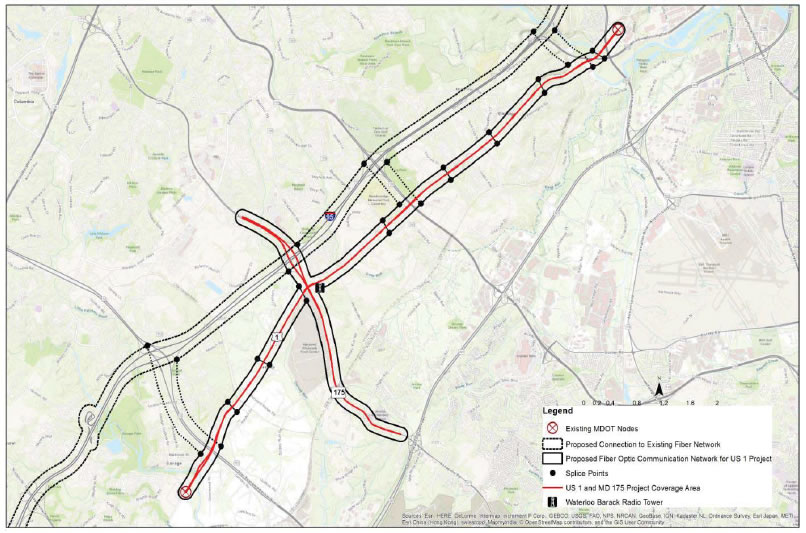
As previously mentioned, the implementation of this ATID project requires the installation of a redundant, reliable and improved communications backbone to support a variety of ITS devices and the CAV applications being considered. Because of the safety-related functions associated with this sort of deployment, a disruption in communications shall be prevented at all costs. To achieve this, a self-healing fiber optic ring will be installed within the limits of the study corridor (I-95 corridor shown in Figure 1). The path of this "fiber-ring" is illustrated in Figure 5. If, by chance, damage to one end of the fiber optic network occurs, communications will continue through the unhindered portion of the network without failure of the dependent systems.
As shown at a very high conceptual level, the proposed fiber optic network will run within the ROW of the identified deployment segment of the US 1 corridor and, through connectivity via the east-west routes (MD 32 to I-195), tie into existing fiber along I-95. Connection to individual devices will then be made using localized connections.
ITS Device Field Deployment
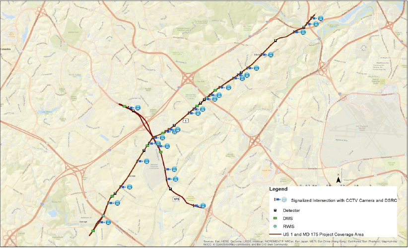
Once the planned communications network, as described above, to support the various applications is in place, the ITS devices/equipment may be deployed and integrated to support the desired functionality. The selected US 1 locations and devices being proposed for each are presented in Table 1, below.
No. |
Signalized Intersection |
Distance to next intersection (Miles) |
CCTV |
DSRC |
Detector |
RWIS |
DMS |
|---|---|---|---|---|---|---|---|
1 |
U.S. 1 at Gorman Rd. |
0.5 |
|
||||
2 |
U.S. 1 at Corridor Rd. |
0.7 |
|
|
9 |
||
3 |
U.S. 1 at Guilford Rd. |
0.6 |
|
|
|
|
|
4 |
U.S. 1 at Patuxent Range Rd. |
0.9 |
|
|
|
||
5 |
U.S. 1 at Mission Rd. |
0.6 |
|
|
|
|
|
6 |
U.S. 1 at Assateague Dr. |
0.2 |
|
|
|||
7 |
U.S. 1 at MD 175 |
0.4 |
|
|
|
||
8 |
U.S. 1 at Port Capital Dr. |
0.1 |
|
|
|||
9 |
U.S. 1 at Montevideo Rd. |
0.8 |
|
|
|
||
10 |
U.S. 1 at Business Pkwy |
0.2 |
|
|
|||
11 |
U.S. 1 at Dorsey Rd. |
0.5 |
|
|
|
|
|
12 |
U.S. 1 at MD 100 EB Ramp |
0.2 |
|
|
9 (On the bridge over MD 100) |
||
13 |
U.S. 1 at MD 100 WB Ramp |
0.45 |
|
|
|
||
14 |
U.S. 1 at Troy Hill Dr. |
0.5 |
|
|
|||
15 |
U.S. 1 at Ducketts Ln. |
0.2 |
|
|
|||
16 |
U.S. 1 at Loudon Ave. |
0.3 |
|
|
|
||
17 |
U.S. 1 at Rowanberry Dr. |
0.6 |
|
|
|||
18 |
U.S. 1 at Montgomery Rd. |
1.17 |
|
|
|
||
19 |
U.S. 1 at Levering Ave. |
0.5 |
|
|
|||
20 |
U.S. 1 at I-195 Southbound Loop |
0.1 |
|
|
|
||
21 |
U.S. 1 atI-195 Northbound loop |
- |
|
|
|||
22 |
MD 175 at MD 108 |
1.10 to MD 175 at U.S. 1 |
|
|
|
|
|
23 |
MD 175 at Pocomoke Dr. |
0.71 |
|
|
|
|
|
24 |
MD 175 at Oceano Ave. |
0.28 |
|
|
|||
25 |
MD 175 at Dorsey Run Rd. |
1.18 |
|
|
|
||
26 |
MD 175 at National Business Pkwy |
- |
|
|
A detailed map of the US 1 Innovative Technology Deployment Corridor sites is also available in Figure 6. As shown, the devices listed in Table 1 are depicted at conceptual locations to satisfy preliminary engineering design and the purpose of this report. As mentioned above, exact locations will be determined during the detailed design phase, which is to be conducted by the OOTS-TEDD.
Proposed Roadway Monitoring, Signal Operations & CAV Deployment
The goal of this ATID project is to deploy ITS equipment along the US 1 corridor to facilitate
system efficiency, reliability, safety, and mobility using innovation and advanced technology deployments, while considering the reduction of impacts on the environment. The devices and equipment being proposed will serve to make the above-mentioned goals achievable through improved arterial performance and CAV functions/applications. The anticipated benefits of this deployment are a reduction in congestion- and incident-related delay, user cost savings and vehicle emissions.
Roadway Monitoring: As shown in Table 1, CCTV cameras will be deployed along the entire length of the US 1 corridor to provide full-coverage viewing capability for traffic and incident management along the roadway.
Vehicle Detection: A combination of Autoscope and Remote Traffic Microwave Sensor (RTMS) traffic detection devices will be deployed along the corridor to support traffic signal operations, turning movement counts, and mid-block detection for travel time reporting, studies, analysis and system optimization.
DMS Deployment: The DMS locations shown in Figure 6 will support travelers' information dissemination regarding conditions along the corridor, as well as to support the implementation of a Highway Access Alert System to warn motorists of congestion, incidents/events occurring along adjacent freeway systems (i.e. I-95 and MD 295) giving them suggested route and travel options.
RWIS: RWIS system deployment along the corridor will complement MDOT SHA's existing weather operations and associated roadway management capabilities.
Improved Signal Operations: Upgraded DSRC-capable traffic signal controllers will be deployed at all signalized intersections along the corridor (US 1). This will support OOTS' intention to operate a fully adaptive signal system along US 1 between MD 32 and I-195. However, coordination with the City of Laurel, Anne Arundel County Department of Public Works (DPW), and Howard County (DPW) will be required for this effort. The proposed upgrade of the signal system in this area will also support the intent to test and deploy CAV applications along the corridor.
CAV Deployment: MDOT SHA, through this ATID project, intends to reap the full safety, mobility and environmental benefits available to the agency and public at large from the identified CAV applications to be tested on the corridor. DSRC equipment will be deployed to support high-speed V2I/I2V data exchange/communications. As mentioned earlier, the following applications, as much as is practical, are being considered for implementation along US 1:
Safety
- Red Light Violation Warning (RLVW);
- Spot Weather Impact Warning (SWIW); and
- Reduced Speed/Work Zone Warning (RSWZ).
Mobility
- Advanced Traveler Information Systems (ATIS);
Intelligent Traffic Signal System (I-SIG);
Emergency Signal Priority (PREEMPT);
Transit Signal Priority (TSP) and Freight Signal Priority (FSP); and
Mobile Accessible Pedestrian Signal Systems (PED-SIG).
Environment
- Connected Eco-Driving; and
Eco-Approach and Departure.
Data Collection, Analysis & Reporting: As with any roadway deployment that the agency implements, performance data and metrics are collected, processed, analyzed, reported and archived. Also, as previously mentioned, the various performance metrics will be used by CHART and its partners for system improvements and data sharing purposes. Systems such as the RITIS, CHART Reporting Tool, etc. benefit from SHA-supported data feeds. This ATID project will be no different.
Outsourced Probe Data
Private sector probe data have steadily advanced in granularity, arterial market penetration and reduced latency, making them indispensable resources used to complement the traffic data collection efforts of the agency. These sources are not limited either spatially or temporally, and can provide accurate speeds and travel times on virtually all major links in a region. However, the reliability of outsourced traffic data through providers such as HERE, Inc., INRIX, TomTom, and Google/Waze are less than perfect on arterial roadways such as US 1, and the devices/equipment to be deployed as part of this ATID project will assist the agency with the validation of the traffic performance data received from these third-party providers.
Other RITIS Data: Incident, CAD, Transit, and Crowd-Sourced Data
Many other data streams are already funneled into RITIS from various agencies, roadside sensors, cameras, agency computer aided dispatch, transit vehicle locations, and connected fleets. These are all fused, standardized, filtered, and made available to a wide variety of end users and systems. CHART Operations currently relies on RITIS both through the RITIS application GUI and through a direct data interface to the CHART ATMS.
Data Fusion, Analysis, Modeling and Simulation
As noted previously, research is currently underway at UMD to develop a real-time decision support and predictive analytics engine. Current development of the MITAMS Mesoscopic Simulation Model includes plans for having the capability to serve a future DSS fusion engine. Related DSS research is examining the use of modern machine learning and predictive analytics coupled with machine-learning techniques to find connections and correlations between seemingly disparate bits of information. These methods can find obscure relationships within hundreds of streams of data to predict network degradation before it occurs. In the future, when this capability is coupled with advanced optimization algorithms, actions can be identified to influence and control traffic flow to keep the key flow metrics optimized (e.g. average link travel times across each local network). Then the same communications channels that bundle and carry the data streams to the CHART ATMS will distribute commands the other way. At some point in the future, a simulation based DSS, combined with advanced machine learning techniques and integrated with the CHART ATMS, will accommodate less human interaction from operators leading to efficiencies in rapidly deploying responses to network traffic fluctuations.
Operations & Maintenance Plan
Similar to CHART's existing deployments, the operations and maintenance of the ITS device
portion of this project will be handled in-house. The CHART ATMS will absorb the data available through the highway-operations-related field devices for use during roadway monitoring, traffic and incident management, travelers' information, emergency weather operations and special event management. The physical maintenance of the devices in the field will be handled by CHART- CD personnel. The traffic signal operations will be the responsibility of OOTS-TDSD and OOTS- TOD. The maintenance of the traffic signal equipment will be managed by this office (OOTS).
It should be noted, however, that the funding provided through this ATCMTD grant opportunity will not be used for O&M purposes. Dedicated funding for O&M, as part of the CHART Annual Operations Budget, will be used to support maintenance efforts.
Projected Benefits and Performance Management
Our system will first address the challenges listed previously related to safety, congestion, and energy & greenhouse gases, with secondary goals and benefits related to advancing and integrating freeway/arterial operations in ways that make the proposed strategies/deployments reproducible and cost-effective. MDOT SHA is a national leader in performance management, and the current data and performance driven approach will enable us to meet our agency's goals in serving our customers with innovations, technology and private sector partnerships.
The implementation of the various ongoing projects, initiatives and strategies previously mentioned, and specifically this US 1 Innovative Technology Deployment project, will present the agency with an opportunity to further boost its already long list of safety, mobility, environment and user benefits – some of which are presented and discussed below.
Reduction in Primary and Secondary Incidents
Instantaneously combining real-time traffic signal phase data with a prediction from a connected vehicle that a red light is about to be violated can result in a life-saving warning for motorists. Likewise, knowledge that a sudden stoppage on a roadway is just ahead, or clearing an incident faster so the dangerous tail dissipates, are other ways that the advanced technologies we will implement can improve safety. These application areas are critical aspects of our proposal. For example, the deployment of the most current and affordable advanced roadway monitoring, detection and traffic control technologies along the US 1 corridor to influence travel choices and provide multi-modal options through improved traveler information and guidance (e.g., arterial CCTV cameras and arterial DMS) will aid in the reduction of primary and secondary incidents.
Reduction in Delays
With conservative estimates that show approximately $500,000,000 in user delay costs within the
I-95 corridor, even a very modest increase in throughput and speeds (less than seen by other ICM deployments) has the potential to see a significant reduction in user delay costs and will be a major benefit of this project. The anticipated reduction in delay produced by improved operations along the US 1 corridor is expected to further propagate to feeder/adjoining routes that would show an even greater benefit in the many tens of millions of dollars annually. Again, the goal of this ATID project is to deploy ITS equipment along the US 1 corridor to facilitate system efficiency, reliability, safety and mobility using innovation and advanced technology deployments, while considering the reduction of impacts on the environment. The devices and equipment being proposed will serve to make the aforementioned goals achievable through improved arterial performance and CAV functions/applications. The anticipated benefits of this deployment are a reduction in congestion- and incident-related delay as well as user cost savings, and vehicle emissions.
Energy Usage
UMD has partnered with the National Renewable Energy Lab (NREL) to add RITIS-based tools for energy and emissions monitoring so that agencies can analyze environmental impacts of congestion, in concert with safety, health, financial and mobility impacts. An anticipated research focus under the CAV deployment is to integrate energy and greenhouse gas monitoring, along with probe data analytics, to create a first-ever, dynamic incorporation of energy and GHG metrics into both real-time transportation operations and investment decision-making.
Implementation Challenges
Local vs. State Interests in Traffic Diversion
Past arterial corridor deployment plans have faced issues with local authorities who do not want diverted freeway trips backing up their local grids. MDOT SHA has been addressing this in the early stages of planning meetings, inviting local stakeholders to sit at the table early in the process.
Considering the anticipated benefits of this ATID project, local stakeholders are expected to embrace the idea of improved operations through innovation and advanced technology deployments.
Potential Unintended Consequence that may Reduce Safety & Mobility
The distribution of more transportation information to road users involves risks that vehicle
operators will use smart phone apps and other mobile devices to access the data, which could result in an accident. The team has begun a partnership with Google/Waze who is interested in working with MDOT SHA to develop new safety applications utilizing SPaT data from signals to help reduce crashes and provide user alerts in a safe, more effective manner.
Skepticism
Skeptics can challenge the value of investing in CAV applications and "smart" traffic signal control networks by pointing out that many of the promised benefits can be realized just by keeping existing timing methods optimized and up-to-date. It is true that for well-timed networks, the benefits of reflexive control may be nominal during fully-loaded peak periods. However, significant efficiencies can be expected along the proposed corridor during peak and off-peak hours, when excess capacity is usually available; and also when incidents or unusual events take place. Furthermore, fixed optimization plans that grow old will now always be optimized. This also removes the expense to constantly re-time signals. Lastly, centralized control with adaptive control and performance measures will identify and prioritize sites that need work. In many cases the needed adjustments can be made without leaving the traffic management center.
Leveraging Existing Resources
Maryland DOT SHA's CHART ATMS Platform and the Statewide Operations Center
MDOT SHA's CHART program is a cooperative effort among SHA, MDTA, MSP, and other local jurisdictional transportation entities statewide. The five (5) major functions of the CHART program are: (1) Traffic & Roadway Monitoring; (2) Traffic Management; (3) Incident Response & Management; (4) Travelers Information; and (5) Emergency Weather Operations.
As previously described, the CHART ATMS is an open system configuration capable of communicating with multiple agencies and systems nationwide. This enables the Statewide Operations Center (SOC) to coordinate and cooperate with multiple transportation and emergency management entities throughout the state and Baltimore-Washington region. The SOC, is supported by smaller Traffic Operations Centers (TOCs) strategically located statewide to carry out the functions of the program, as well as to provide a level of redundancy. The Office of CHART has civil and software engineers, TMC and Field Operations staff to accomplish the above functions, and this US 1 project provides an opportunity for the agency to integrate traffic signal and CAV operations into the ATMS, which will provide the tools needed for a well-rounded integrated corridor management system.
CHART's existing cooperation and agreements with the various jurisdictional-based transportation, law enforcement, and emergency management agencies will also contribute to the inter-agency coordination and teamwork necessary to make this ATID implementation a success.
RITIS -- The Regional Integrated Transportation Information System
RITIS is an automated data sharing, dissemination, and archiving system that includes many performance measure, dashboard, and visual analytics tools that help agencies to gain situational awareness, measure performance, and communicate information between agencies and to the public. More information regarding RITIS can be found in Appendix D.
Partnering Plan
The nature of this US 1 Innovative Technology Deployment project requires formal and informal intra- and inter-agency partnerships with various organizations. The traffic signal, highway operations, analysis, and CAV elements of this project will demand input and participation from a number of offices and organizations to implement and manage the proposed deployments along the US 1 corridor. A summary of these offices/organizations, as well as their roles/responsibilities are as follows:
- MDOT SHA: MDOT SHA will be the lead agency and will be responsible for all program and project management associated with this project. The divisions/offices that will be involved in this project are:
- CHART: Responsible for all project administration, preliminary engineering design, design requests and operations and maintenance (through CHART-CD) of the ITS portion of the system deployment.
- OOTS-TDSD: In charge of the design and implementation of all traffic signal-related upgrades, timing plans and optimization. TDSD will also investigate compliance with safety and overall engineering codes and principles.
- OOTS-TEDD: Responsible for the detailed engineering design, project plans, specification and estimates.
- OOTS- Contracts & Finance Division (CFD): Responsible for project advertisement, contract award and notice-to-proceed to the Contractor.
- OPPE-Data Services Engineering Division (DSED): Intra-agency coordination and cooperation, system performance monitoring and data reporting.
- OOTS-TOD: Construction administration and traffic signal device field operations and maintenance activities.
- Office of Finance (OOF)-Federal Aid Division: Obtaining Federal Authorization to activate the use of the funding received through this grant.
- UMD-CATT: Research and data analysis, engineering coordination, and general project support. The development, monitoring and analysis of improved performance metrics, and subject area expertise will be its contributions to the implementation of this project.
- Howard County DPW: Coordination and cooperation support.
- City of Laurel: Coordination and cooperation support.
- Town of Jessup: Coordination and cooperation support.
- BMC: Coordination and cooperation support.
- FHWA – Maryland Division: Coordination, cooperation and guidance regarding Federal regulations, the programming of Federal funding and project oversight.
Schedule
The key project deliverables and milestones are as follows. A Gantt CHART for these
deliverables is available in Appendix I.
Project |
Description |
Due Date |
Section 508 |
|---|---|---|---|
Programming of Funds |
Involves working with USDOT and MDOT SHA's OOF to obtain Federal Aid Approval and to activate funds |
Within 3 Weeks of Award |
Yes |
Kick-Off Meeting |
Conducting kick-off meeting with the USDOT, the Project Team, and stakeholders. |
Within 4 Weeks of Award |
No |
Monthly Progress Reports |
Submitting monthly progress reports to the USDOT and MDOT SHA Leadership regarding projects status, and issues. |
Monthly |
No |
Monthly Progress Meetings |
Monthly meetings with the Project Team, USDOT representatives to update all parties |
Monthly |
N/A |
Report to the Secretary |
Annual report describing deployment and operational costs compared to the benefits and savings, and how the project has met original expectations projected in the deployment plan. |
Annually, beginning one (1) year after award. |
Yes |
Complete Detailed Design |
Completing all detailed design documents (plans, specifications, and estimate) in preparation for a competitive e-Maryland Marketplace advertisement. |
December of Calendar Year (CY) 2017 |
N/A |
Advertisement |
e-Maryland Marketplace Advertisement |
Spring of CY 2018 |
N/A |
Award and Notice-to-Proceed (NTP) |
After a competitive bid, a Contractor will be selected to carry out the construction. A formal NTP (in writing) will be issued. |
Summer of CY 2018 |
N/A |
Anticipated Project Completion |
The date all elements will be in place, and all system capabilities available for use. |
Winter CY 2019 |
N/A |
Organizational Structure, Key Personnel and Role Descriptions
Redacted
Redacted
Redacted
Redacted
Redacted
Redacted
Redacted
Redacted
Redacted
Redacted
Redacted
Redacted
Redacted


Redacted
Redacted
Redacted
Redacted
Redacted
Redacted
Redacted
Redacted
Redacted
Redacted
Redacted
Redacted
Redacted
Redacted
Redacted
Redacted
Redacted
Redacted
Redacted
Redacted
Redacted
Redacted
Redacted
Redacted
Redacted
Redacted
Redacted
Redacted
Redacted
Primary Point of Contact
Glenn McLaughlin, P.E., Program Manager – US 1 Innovative Technology Deployment Project
Deputy Director
Office of CHART & ITS Development Maryland Department of Transportation State Highway Administration
Tel: (410) 787-5884
Email: GMcLaughlin@sha.state.md.us
Redacted
Redacted
Redacted
Redacted
Redacted
Redacted
Redacted
Redacted
Redacted
Redacted
Redacted
Redacted
Redacted
Redacted
Redacted
Redacted
Redacted
Redacted
Redacted
Redacted
Redacted
Redacted
Redacted
Redacted
Redacted
Redacted
Redacted
Redacted
Redacted
Redacted
Redacted
Redacted
Redacted
Redacted
Redacted
Redacted
Redacted
Redacted
Redacted
Redacted
Redacted
Redacted
Redacted
Redacted
Redacted
Redacted
Redacted
Redacted
Redacted
Redacted
Redacted
Redacted
Redacted
Redacted
Redacted
Redacted
Redacted
Redacted
Redacted
Redacted
Redacted
Redacted
Redacted
Redacted
Redacted
Redacted
Redacted
Redacted
Redacted
Redacted
Redacted
Redacted
Redacted
Redacted
Redacted
Redacted
Redacted
Redacted
Redacted
Redacted
Redacted
Redacted
Redacted
Redacted
Redacted
Redacted
Redacted
Redacted
that this does not include O&M costs, which will be supported by the CHART Annual Operations Budget.
The MDOT SHA state-match will be obtained from the following sources:
- MDOT SHA Fund 86 ($4.3M): CHART and ITS Deployment Program Fund
- MDOT SHA State Planning & Research (SPR) Funds ($500K): State Planning Fund
- MDOT SHA Fund 76: Safety and Spot Improvement Program Fund (Additional funds will be provided, as needed).
- MDOT SHA Fund 85: Traffic Management Program Fund (Additional funds will be provided, as needed).
- MDOT SHA Fund 87: Congested Intersection Program Fund (Additional funds will be provided, as needed).
*NOTE: For a more detailed breakdown of costs, please refer to VOLUME 2 ("Budget
Application") of this ATCMTD proposal.
Assumptions and Conditions
The costs above were developed based on an estimate generated by MDOT SHA and its partners. The assumption for this funding request ($8,376,500) is that all of the design, device installation, system integration and capabilities will be fully deployed over the 1.5-year timeframe (from award of the contract to project completion). MDOT SHA, through the CHART Annual Operations Budget, will operate and maintain the deployed corridor improvements.
Although this project is currently well-defined, there are other opportunities for scaling within the proposed US 1 Corridor, and our team would welcome opportunities to explore these scaling options with the USDOT.
Upon award, MDOT SHA will work closely with the FHWA and UMD to develop a more detailed scope of the work to be performed. Specific efforts will be taken to integrate the existing SHA projects for a successful ATCMTD. It should also be noted that some of the technology products/solutions and data/ industry partners identified in this proposal could be modified/refined to align the project for better integration and successful deployment.
1 Source: 2014 American Community Survey, U.S. Census Bureau;
http://factfinder.census.gov/faces/tableservices/jsf/pages/productview.xhtml?src=bkmk [Return to Note 1]