Rural Enhanced Automated Communication of Hazards (REACH): Advanced Transportation and Congestion Management Technologies Deployment (ATCMTD) - Notice of Funding Opportunity Number 693JJ317NF000
Volume 1 - Technical Application
1 Introduction
The University of Iowa (UI), in partnership with the Iowa Department of Transportation (DOT) is pleased to submit this application for the Advanced Transportation and Congestion Management Technologies Deployment Initiative (ATCMTD). This funding opportunity comes at an ideal time, as the UI and state are pushing quickly forward in the field of advanced and connected technologies to serve our diverse population. With this proposal, we are striving to bridge the digital divide in transportation, as the benefits of advanced and connected vehicle technologies, including mobility, economic vitality, and safety, should not be defined by one's address or by city, county, or state borders. As consistently one of the top agricultural producing states in the US (USDA Economic Research Service), as well as one of only ten USDOT designated Automated Vehicle Proving Grounds (AVPG), Iowa is uniquely positioned to be a leader in assessing and effectively deploying advanced and connected vehicle technologies to benefit the safety of those traveling rural roads.
To address the safety needs of rural road users, the UI and Iowa DOT are requesting $2.5 million in grant support for the Rural Enhanced Automated Communication of Hazards (REACH) project, a holistic approach that accelerates the deployment of a highly advanced and connected transportation system to these areas. REACH includes two key objectives: (1) providing drivers in rural areas with critical alerts of upcoming specialty vehicles, such as tractors, school buses, and emergency vehicles, to prevent crashes from occurring, and (2) when crashes do occur, improving the connection between crash scene first responders and the receiving trauma centers to increase a victim's chance of survival.
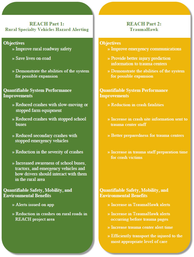
These two key objectives would be addressed through two parallel programs, or parts, in the REACH project. Part 1 of REACH focuses on hazard alerting of specialty vehicles. This portion of the project includes the deployment of Automatic Vehicle Location (AVL) technology in tractors, school buses, and emergency vehicles and connecting them to the Iowa DOT's HERE© datafeed cloud. By downloading a smartphone app, drivers on rural roads will be provided with timely alerts and warnings of nearby slow-moving or stopped tractors, school buses, and emergency vehicles which may not be visible due to sharp curves, steep hills, or obstructions. Connecting these vehicles to the cloud and alerting drivers accordingly may have a profound impact in improving the awareness of these vehicles, reducing crashes, and saving lives.
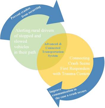
Figure 1: REACH Vision
Part 2 of REACH focuses on improved emergency services communication by accelerating the deployment of TraumaHawk, an existing mobile phone application created by the UI that provides trauma center medical staff with on-site, crash-related information from first responders to prepare for the arrival of victims and their specific injuries. Efforts under this proposal would greatly extend the scale of this project more widely across the rural area.
As an AVPG, the UI and Iowa DOT fully intend to share results from this deployment and collaborate with entities across the country to encourage the possibility of similar deployments in other rural areas. Based on the success, results, and lessons learned from REACH, these advanced technologies could be scaled nationwide to benefit those using the six million miles of rural roads every day. And while REACH focuses on rural roads, the principles apply to all roadway types, including urban streets and freeways. The UI and Iowa DOT are committed to promoting our experiences and lessons learned (including activities covered under this proposal) to benefit everyone in the US and continue to move us toward a zero traffic fatalities society.
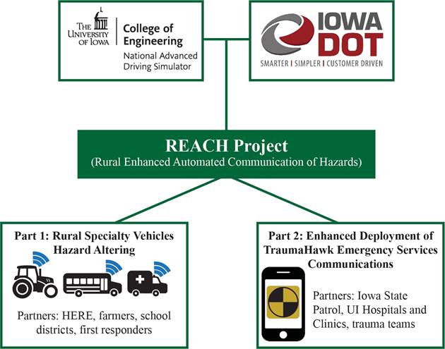
Figure 2. REACH project
2 The University of Iowa
REACH is a partnership between the UI and Iowa DOT. For this award, the UI National Advanced Driving Simulator (NADS) will lead the REACH project and funding, with the Iowa DOT fully involved in every component and providing oversight for the duration of the grant. REACH builds on current collaborative projects between the UI and Iowa DOT, including the Automated Vehicle Technologies Project and TraumaHawk program. Through both of these endeavors, as well as many others, the UI and Iowa DOT are dedicated partners in our common goal of improving roadway safety.
The partnership between the UI and Iowa DOT is a long-standing and successful one; effective April 9, 2003, the UI and Iowa DOT entered into a signed, written Transportation Research Collaboration Agreement to facilitate transportation research in the state.
Additional REACH partners not involved in the management of the grant but necessary for successful deployment, such as private sector and public agencies, are detailed in Section 9 of this proposal.
3 Geographic Area
REACH encompasses the USDOT designated Iowa City/Cedar Rapids Corridor AVPG and surrounding rural areas. Located in Eastern Iowa, the AVPG spans the I-80 and I-380 highway/interstate corridors in adjacent Johnson and Linn counties. As these two counties are primarily populated by urban residents (Table 1), REACH proposes to include the nine counties bordering Johnson and Linn counties, as shown in Figure 3. Many residents in these bordering counties commute to the urban areas in Johnson and Linn counties for work, education, recreation, and leisure.
https://www.census.gov/programs-surveys/geography/guidance/geo-areas/urban-rural/2010-urban-rural.html
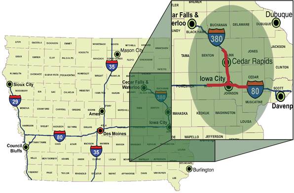
Figure 3. Iowa REACH project geographic area. Shaded oval highlights Johnson and Linn counties (center), plus their nine bordering counties. Segments of the I-80 and I-380 corridor included in the Iowa City/Cedar Rapids Corridor AVPG are highlighted in red.
REACH is a geographically diverse project, proposing the deployment of advanced technologies to primarily benefit those traveling rural roads, areas not typically emphasized in current automated, advanced, and connected vehicle technology testing. The REACH project area contains nearly 1,000 miles of paved rural primary roads and more than 10,000 miles of secondary roads (Iowa DOT, 2016). There are just under 12,000 farms, totaling more than 3.4 million acres of land (USDA Census of Agriculture, 2012) and more than 60 school districts in this 11-county area.
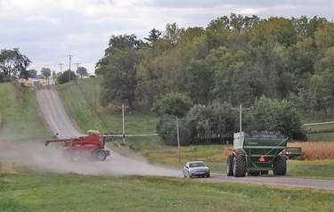
Figure 4. Farm equipment and vehicle on a gravel roadway in REACH project area.
4 Real World Issues and Challenges
Communities across the country are welcoming the testing and limited deployment of more highly automated, connected, and advanced vehicle safety technologies to address various mobility, economic, and environmental issues, as well as improving overall quality of life. However, much of the emphasis of deployment and testing is concentrated in urban and higher density areas. While testing in the urban core is a vital component to effective planning for advanced vehicle technology systems, rural settings and landscapes account for 72% of the nation's land area (Rural America at a Glance, 2016).
4.1 The Hazards of Rural Roads
While only 19% of the US population lives in rural America, in 2015 49% of traffic fatalities occurred in rural areas (NHTSA, Traffic Safety Facts). Crash fatality and injury rates are higher on rural roadways than other roadway types, with rural fatality rates being more than twice as high as urban rates for a wide variety of injuries (Peek-Asa et al., 2007).
As rural roads were originally designed (some over 100 years ago) for slower speeds and much less traffic than what they carry today, these areas face a number of unique roadway safety challenges. Rural crashes are more likely to be at higher speeds. Roadway designs may include issues such as sharp curves and steep grades, resulting in limited sight distances, as well as limited shoulders. Major contributors to the severity of rural crashes include hazards close to the roadway, such as ditches, culverts, utility poles and trees (FHWA).
Additionally, many generations of farm equipment travel rural roadways. While complying with safety standards when originally built, some equipment may not meet the lighting and marking standards required of new machinery today. This poses further challenges to driving in rural areas.
Figure 5. Steep hill in REACH project area followed by uncontrolled four-way intersection.
4.2 Farm Equipment on Rural Roads
Continuing urbanization of traditionally rural areas has led to a substantial increase in the mix of agricultural equipment and vehicles on rural roadways (Committee on Agricultural Safety and Health Research and Extension, 2003). Additionally, farms are increasing in size, often by acquisition of non-contiguous land, and there's a trend towards greater management of farms by renters/leasers. These factors, along with other changes, are leading to an increased mix of farm equipment with faster moving vehicles on rural roads (Schwab, 2009).
Though farm tractors and other self-propelled equipment (excluding farm trucks) are involved in less than 0.05% of total motor vehicle accidents in the US, the percentage of all fatal motor vehicle crashes involving farm equipment is almost five times higher (Hanna et al., 1997). In a review of farm equipment crash data from nine state DOTs, including Iowa, it was found that there were more than 7,000 crashes involving farm equipment reported from 2005-2010. About 70% of these crashes occurred in rural zip codes (Great Plains Center for Agricultural Health). See Figure 6 for a map of crashes involving farm equipment.
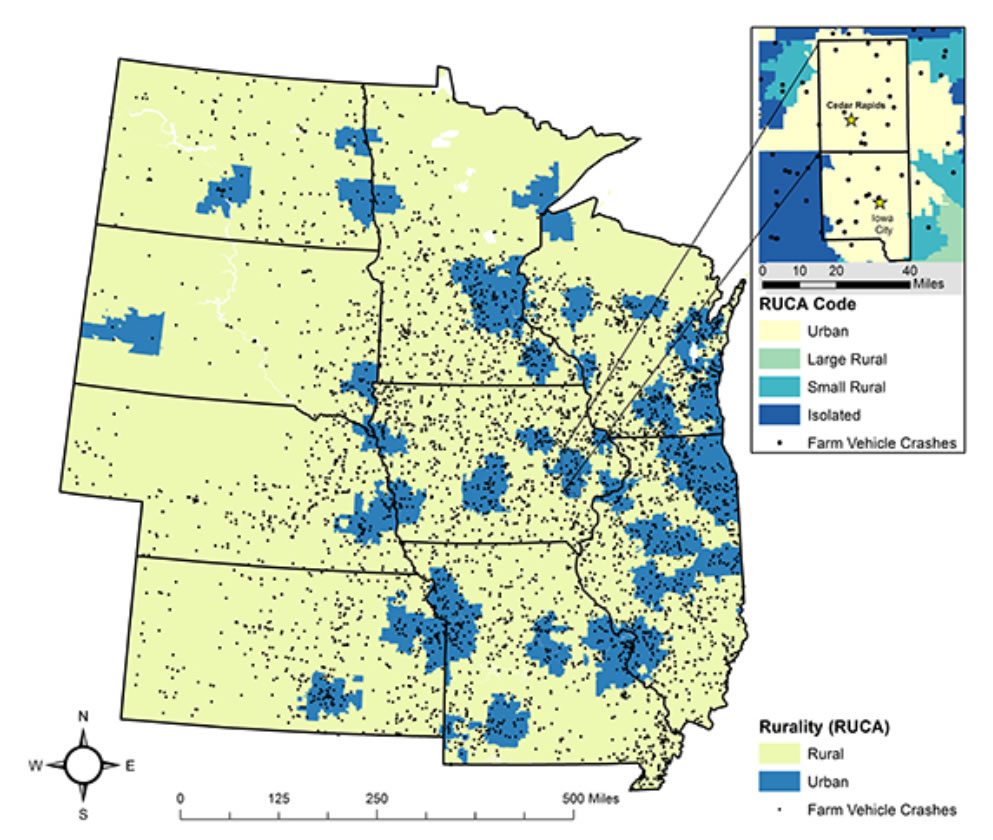
Figure 6. Crashes involving farm equipment in the Midwest region (2005 to 2010)
(Great Plains Center for Agricultural Health, https://gpcah.public-health.uiowa.edu/center-projects/farm-%20equipment-crash-study/)
The most common collisions occur when an approaching motorist hits a farm vehicle from behind (front to rear-end collision), or when a passing motorist hits a farm vehicle that is attempting to make a wide left turn (left sideswipe). These two scenarios account for about 22% of the total number of vehicle-to-vehicle collisions that involve a farm vehicle. The average age of the US tractor fleet is more than 25 years old and, currently, no US state laws mandate the retrofit of these older tractors. Without adequate lighting and markings, these vehicles can be difficult for motorists to identify quickly (Ramirez et al., 2016).
Collisions involving farm vehicles are about five times more likely to produce a fatality due to a number of reasons, including:
- Large differences in relative speed give little time for reaction and increase the amount of energy dispersed upon collision
- Drivers may not expect farm vehicles
- Drivers unfamiliar with farm vehicles may not recognize what they are approaching (e.g., vehicle outline different from a car/truck, lighting and reflectors different, equipment may be carrying a load) and are unaware of the hazards presented
- Due to generations of farm equipment in use today, it is common for signage and front/rear lighting not to be adequate by current standards
- Drivers may not understand the limitations associated with farm equipment (e.g., the need to swing right before making a wide left turn)
- Drivers may not see hidden field entrances
– Great Plains Center for Agricultural Health
Approximately 35% of Iowa's 3.1 million residents live in rural areas (State of Iowa State Data Center) and forty-six of Iowa's 99 counties have fewer than 15,000 residents (Eleven Maps that Explain Iowa). While Iowa is on the lower end of the rural-urban continuum (sparsely populated throughout), the state also has the highest rate of farm equipment crashes reported on public roads in the US at 107 per 100,000 population (Costello, Schulman, and Luginbuhl, 2001). An analysis of US FARS data found that, in crashes with a farm vehicle, the farm vehicle occupant was killed nearly twice as frequently as the other vehicle occupant involved in the crash (Gerberich et al., 1996). Additionally, in 2013, Iowa DOT data showed that 235 of the total statewide 317 crash fatalities occurred on rural roadways (Iowa DOT 2040 Long Range Transportation Plan); though not all of these crashes involved farm vehicles, this ongoing trend illustrates the significantly greater risk to those traveling our rural roadways.
Figure 7. 2016 fatal crash in REACH project area. A semi driver collided with a tractor turning left on a rural Johnson County, Iowa road. The driver of the tractor was ejected and died (KCRG).
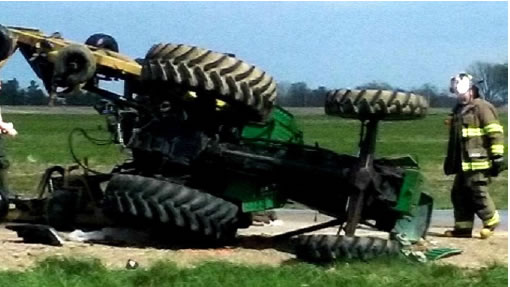
Figure 8. 2017 fatal crash immediately south of REACH project area. Tractor hauling a three-wing mower on Iowa Highway 218 rear-ended by a car and overturned. Tractor driver died and car driver cited for following too closely (KWWL).
4.3 School Bus Crashes and Rural Transport
According to NHTSA, every year the nation's 450,000 public school buses travel more than 4.3 billion miles to transport 23.5 million children to and from school and school-related activities (NHTSA's Unedited Summary of School Bus Report, 2016). Between 2005 and 2014, there were 1,332 people killed in school transportation-related crashes, an average of 133 fatalities per year. Of those who lost their lives, 71% were occupants of the other vehicle involved in the crash. Additionally, 111 school-age pedestrians died in transportation-related crashes, with 36% being struck by other vehicles involved in the crash (National Center for Statistics and Analysis, 2017).
According to the Iowa Department of Education, the state's average school boundary is about 161 square miles. Some, though, are far larger: the largest school district in Iowa, just northeast of the REACH project area, covers 555 square miles. With 338 districts covering the state's 56,272 square miles, this means that districts are traveling long distances to transport students, particularly in rural communities. For some rural students, riding time can be as long as 60-75 minutes one way (Clayworth and Litchfield, 2015).
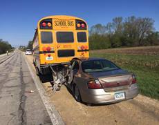
Figure 9. 2016 rural Iowa bus crash (Fayette County). Car driver rear-ended stopped school bus. Non-fatal crash (Fayette Co. Sheriff's Office).
Figure 10. 2016 rural Iowa highway fatal bus crash in REACH project area (Springville Community School District). Car driver rear-ended stopped school bus. One child was taken to the hospital and the driver of the vehicle died. (The Gazette). See letter of support included in Appendix B.
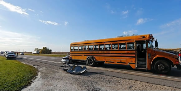
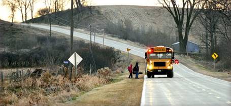
Figure 11. Children board a school bus in rural western Iowa (Sioux City Journal)
4.4 Secondary Crash Risk on Rural Roads
Secondary crashes on all roadways pose great risk to nearby drivers, as well as on-scene first responders, particularly rural roads. Rural roadways are often one-lane in each direction, without a shoulder. This does not leave much area for first responders and emergency vehicles to safely address the scene of a crash. Combine that minimal area with steep hills, sharp curves, obstructed views, and dark or poor visibility conditions, and an approaching driver's ability to see a crash scene ahead may be compromised.

Figure 12. Iowa DOT 2016 social media post highlighting the dangers of secondary crashes. In this clip, a truck is seen swerving off the road because it wasn't able to stop in time as it approached stopped traffic ahead.
According to the Iowa DOT Traffic Management Center, the average time for all lanes to be cleared for an urban lane-blocking incident in April 2017 was 38 minutes. During this same period, the average roadway clearance time on rural roads was double that figure at 76 minutes. Additionally, in winter months, roadway clearance times extend well beyond these averages.
Each minute of a traffic incident increases the likelihood of a secondary crash 2.8% and might account for 20% of all crashes. The secondary crash zone is not just the immediate area around the crash, but also within the queue resulting from the original incident, which can extend miles before and after the crash. Secondary incidents can be more severe than the original incident, due to slow-moving traffic or stopped queues on the roadway.
4.5 Medical Response in Rural Areas
When crashes do occur on rural roadways, it often takes first responders longer to arrive at the scene of the crash, meaning victims wait longer for medical attention (FHWA). In 2015, the fatality rate per 100 million vehicle miles traveled was 2.6 times higher in rural areas than in urban areas (National Center for Statistics and Analysis, 2017), with pre-hospital time being a major factor (Gonzalez et al., 2006).
Swift response from emergency personnel can save lives of those involved in a traffic crash. In 2015, rural drivers represented 57% of those who died en route to hospitals, compared to 42% for urban drivers (NHTSA, Traffic Safety Facts).
When crashes occur in rural areas, the critical timing of emergency response can mean the difference between life and death. Lack of technology in rural areas can also contribute as advanced crash notification may not be as readily available, cell phone service may be less reliable, and communication to additional emergency response may be difficult."
Beyond Traffic 2045
Rural areas in Iowa have experienced increased emergency response time. Minimum response time in Iowa for first responders is 15 minutes in the rural areas compared to five minutes in the urban areas. Additionally, many rural areas are serviced by volunteer-related services or other nearby ambulance services. The minimum response time for an ambulance that is not functioning as the first responder is 20 minutes in the rural area, compared to eight minutes in the urban areas. Advanced life support minimum response times are the same (Iowa EMS Standards, 2010).
There are currently only two Level 1 trauma centers located in the state of Iowa: the UI Hospitals and Clinics in Iowa City and Iowa Methodist Medical Center in Des Moines. The UI Hospitals and Clinics receives more than 1,070 patients transferred by helicopter and cares for nearly 50,000 emergency-trauma center visits in an average year. When minutes and seconds count, Iowans in more remote rural areas may face extensive travel times to necessary critical care services.
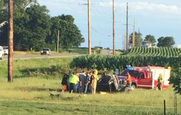
Figure 13. Fatal crash along rural road in REACH project area. First responders work at this 2016 crash that involved a driver with four passengers who lost control, dropped off onto the shoulder, over-corrected, crossed the centerline, and broadsided another vehicle. Three passengers died; the driver and one passenger were transported to the UI Hospitals and Clinics more than 30 miles away and survived (KCRG).
5 REACH Project Details
The REACH project has been developed to address these real-world challenges that individuals traveling our rural roads face in regards to stopped or slow-moving specialty vehicles, as well as delayed medical response.
The REACH project is divided into two independent, parallel project components that both serve to improve roadway safety for rural residents:
- Part 1: Rural Specialty Vehicles Hazard Alerting
- Part 2: Expanded Deployment of TraumaHawk Emergency Services Communications
5.1 Part 1: Rural Specialty Vehicles Hazard Alerting
REACH Part 1 is the deployment of a connected vehicle safety application system that establishes sources of high-quality driving environment data and processes that data into useful streams of information for roadway users. The technology is a cloud-based connected vehicle platform that delivers critical safety messages and alerts to drivers over cellular networks via a mobile application. The UI and Iowa DOT currently have a field-ready, proven technology set up with HERE© in REACH's geographic area for other types of safety applications, including warnings about weather events, work zones, crashes, and wide moving jams.
The project involves expanding the current project to include these new high-priority connected vehicle safety applications by deploying AVL equipment in 80 tractors, 80 school buses, and 40 emergency vehicles that travel rural roads primarily within REACH's geographic project area. The deployment of these AVL boxes (which include a cellular connection) allows for a direct connection to the HERE© cloud, including location and various vehicle data. The tractors, school buses, and emergency vehicles will serve as mobile probes connected to the Iowa DOT's HERE© datafeed cloud. These vehicles will feed location information via the HERE© datafeed cloud that then can alert and prepare other approaching nearby drivers in real-time (approximately 1 second latency).
While all tractors involved in the project will need to be outfitted with new AVL devices, some school buses and emergency vehicles may already have the necessary AVL technology. For these cases, rather than deploying new devices, the REACH team will review the existing AVLs and assess the feasibility of connecting them to the HERE© cloud. For some of these vehicles, it may be as simple as establishing a connection between the AVL device and the HERE© cloud, while others may still require new AVL devices.
Drivers in the rural service area that download the HERE© mobile application on their smartphone will receive an alert of an upcoming tractor, school bus, or emergency vehicle in the roadway as they approach a vehicle outfitted with a REACH AVL. As recognized by the UI and Iowa DOT, stakeholder outreach and engagement are critical to the success of regulation, policy, and public acceptance, partnerships, and technology deployment.
Currently, there are no established datafeeds that connect tractor, school bus, or emergency vehicle location data into the HERE© cloud service or to the general public. Efforts under the REACH proposal include the development and deployment of datafeeds connected specifically to these special vehicles within the rural project area. Alerts will be designed in accordance with applicable standards, safety protocols, and regulations. During early development, the REACH project team will assess the feasibility to additionally notify drivers via the in-vehicle dash. For all rural specialty vehicles, several factors will be assessed for the programming, including the vehicle's position, location, and speed.
5.2 Expanded Deployment of TraumaHawk Emergency Services Communications
TraumaHawk, a smartphone app for use at a crash scene, was developed by the UI to connect first responders to hospital trauma teams. Designed so that on-scene personnel can prepare a report in about one minute, TraumaHawk alerts notify trauma staff to the exact location of the crash, provide relevant photos (first responders can select views of the crash through a simple user interface), and allow for the addition of contextual information. The goal of TraumaHawk is to help predict injuries based on crush and intrusion into the occupant compartment (http://ppc.uiowa.edu/traumahawk). Icons help first responders focus on relevant areas of interest, such as looking for steering wheel deformation, A-pillar compromise, roof crush, and other intrusion into the occupant compartment. On average, conventional EMT pages only provide trauma staff with seven to eight minutes in advance of crash victim arrival. Along with additional crash site information, TraumaHawk alerts provide emergency department (ED) teams with significantly more time to prepare for incoming patients. To date, the TraumaHawk project has completed three successful phases of development.
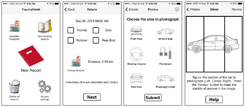
Figure 14. TraumaHawk iPhone 5 interface and screenshots
Development of TraumaHawk was a team collaboration involving law enforcement from the Iowa State Patrol, first responders, Advanced Life Support (ALS) paramedics, and trauma doctors and nurses. Integrating all parties was crucial in ensuring that both the app and process were intuitive and practical for all users. This mobile phone application was created by the UI, with funding from the Iowa DOT.
TraumaHawk was officially deployed in east-central Iowa on October 15, 2013. System tests are currently ongoing in the counties surrounding Iowa City, Iowa, where the UI houses one of the largest Level 1 trauma centers in the Midwest, the UI Hospitals and Clinics. As all data must be secure, iPhones outfitted with the TraumaHawk technology must be government-issued, not personal devices. Currently, 27 secure iPhones have been issued under this project to the Iowa State Patrol.
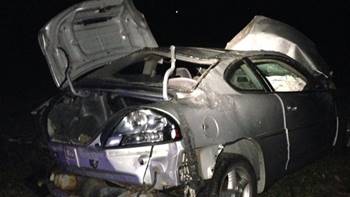
Figure 15. Example TraumaHawk photo of rollover with roof crush
Through Phase II, 40 of the 69 TraumaHawk cases also had conventional EMT trauma pages, allowing for direct comparison in ED advanced notice time. The average time between the EMT-issued trauma team notification page and patient arrival was 12 minutes. With TraumaHawk, the advanced notice received at the trauma center was, on average, 26 minutes before patient arrival, more than doubling notification time.
Expansion of TraumaHawk under REACH would strategically deploy 50 additional, secure iPhones throughout the project's geographic area, with a focus on first responders traveling primarily rural roads or roadways with the most dangerous rural crash statistics in terms of crash prevalence, severity of injuries, and fatalities. The REACH project would consider expanding service, training, and deployment to voluntary first responders (as many rural areas may primarily rely on these services), as well as contracted or public ambulance responders and additional Iowa State Patrol Troopers who attend the most serious crashes.
The minimal number of TraumaHawk iPhones in use today presents a challenge in gauging the benefit of the application. Through Phase III of the TraumaHawk project, out of the 905 cases of motor vehicle crashes presented to the UI Hospitals and Clinics that had conventional EMT trauma pages and were not transferred from another hospital, TraumaHawk alerts were only issued in 69 or 7.9% of these cases. Expanding the deployment of TraumaHawk and increasing the service area would allow for better quantification and evaluation of the program's impact and ultimately aid in saving more lives. Figure 16 provides a map of rural fatal crashes throughout the REACH project area from January through May 2017 alone.
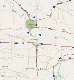
Figure 16. Map of fatal crashes (blue dots) from January to May 2017 in REACH area. Green shaded areas indicate Iowa City and Cedar Rapids urban areas, indicating that nearly all fatal crashes in the REACH project area in 2017 to date have occurred in rural areas.
6 Project Vision, Goals, and Objectives
6.1 Project Vision
Vehicle automation and higher levels of technology are key components to addressing the scourge of injuries and fatalities on our nation's roadways. The Iowa DOT has taken a progressive stance to create an environment where automated driving and advanced transportation technologies can thrive in the state. The UI and Iowa DOT recognize that a connected and advanced transportation system has tremendous opportunities to address the safety, mobility, efficiency, and economic vitality challenges faced by Iowans.
"To deliver a safe, reliable, and efficient transportation system by developing an AV-ready driving environment."
The Iowa DOT's state transportation plan, Iowa in Motion 2045, lays out the goals of safety, efficiency, and quality of life as the basis for decision-making, guiding investments in the state's transportation system. Increased transportation safety through the reduction of crashes is the foremost element in an effective transportation system and safety is an inherent component in the design of all of Iowa's roadways.
The UI and Iowa DOT are taking a methodical approach to preparing for advanced technologies on Iowa roadways. One project vital to this effort is the Iowa DOT's current Automated Vehicle Technologies Project, which includes build-out of an information infrastructure that integrates real-time roadway information with roadway users, drivers, and services. Part 1 of REACH builds on this work, as well as other AV accomplishments in the state, by further deploying advanced technologies that will accelerate the coverage of our automotive-grade information architecture to include the connection of tractors and school buses to the overall advanced transportation system.
With the Iowa DOT vision of zero traffic fatalities, REACH Part 1 strives to prevent crashes from happening in the first place. And, when they do occur, REACH Part 2 helps to provide trauma center staff with advanced, detailed notice of crash site information in order to give victims the best possible chance for survival. Given the increased response time and heightened severity of rural crashes in Iowa and nationwide, the UI and Iowa DOT believe that Part 2 of REACH, which accelerates the deployment of the existing TraumaHawk program, could have tremendous impacts on rural victims' ability to survive a crash. Such information helps trauma centers prepare more specifically for the types of injuries they should expect (McGehee et al., 2015).
The greatest motivation behind the vision for REACH's Part 1 is that more than 94% of crashes on American roadways are caused by some sort of human error (NHTSA). The vision, goals, and objectives of the REACH project strive to continue to decrease that number with a focus on roadways that do not always receive the attention they deserve: our rural roads.
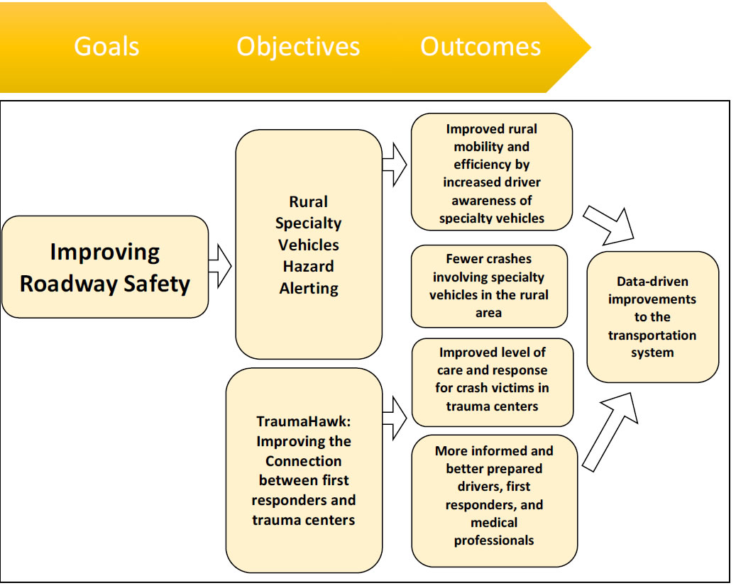
Figure 17. REACH goals, objectives, and outcomes
6.2 Project Goals and Objectives
REACH's success can be assessed by its distinct ability to address the critical goal on Iowa's rural roads of improving roadway safety. Much of the focus on advanced transportation system deployment has been based on in-vehicle solutions (i.e., additional sensors and cameras to the vehicle or performing various functions of vehicle control). While these have made significant improvements to roadway safety, additional high-quality roadway and driving environment data can significantly improve the vehicle's ability to anticipate roadway conditions ahead. A fully vetted, connected, and developed data infrastructure can provide key individuals, leaders, and policymakers with the necessary information to improve roadway mobility and efficiency and support drivers at all ends of the spectrum.
REACH seeks to actively address four of the ATCMTD initiatives, as shown in Table 2.
6.2.1 Improving Roadway Safety
The UI and Iowa DOT are constantly assessing methods and technologies that can improve roadway safety. While much emphasis is concentrated in the urban landscape, Iowa has some of the greatest potential to improve the safety of our rural roads. The driving force behind shifting the emphasis to the rural landscape is the prevalence and severity of crashes on Iowa's rural roads as discussed in Section 0.
The UI and Iowa DOT believe that both Part 1 and Part 2 of the REACH project have a profound opportunity to enhance safety on the rural roadways. These technology advancements and solutions will enhance existing AVL and TraumaHawk technologies to increase safety as well as crash injury data. Such enhancements will save lives, as well as reduce injuries and costs.
6.2.2 Data Driven Improvements
The UI and Iowa DOT foresee an advanced transportation system that can not only improve the safety for Iowans, but also improve the overall efficiency of our roadways. The UI and Iowa DOT's datafeeds rely on the HERE© mapping cloud feeds that provides a comprehensive amount of real-time traffic data to the driver, including traffic flow guidance. Beyond route and navigational guidance, the alerts can enhance mobility by connecting drivers with powerful predictive models that incorporate real-time weather and traffic data. These data empower travelers and vehicles with precise information on what lies ahead.
All technologies deployed in the REACH vision will include data metrics and measurable results to assess the performance of the transportation system. Data assessment opportunities include efficiency analyses, response time assessments, alert performance actions and many others. The REACH team will constantly monitor the system's performance and utilize the data to identify and inform the transportation system's opportunities for improvement and strengths. This data will also be publicly available via the UI's AVPG Community of Practice to help other entities inform and improve their transportation system.
7 Transportation Systems and Services Included
7.1 Advanced Transportation Information System
As REACH Part 1 and Part 2 involve improving the information connection to travelers, as well as between crash scene first responders and trauma centers, limited infrastructure-related transportation systems and services are included in the project. As mentioned previously, the cloud platform developed by HERE© will be utilized. A significant benefit to this approach is the cloud set-up and mobile application have already been configured, tested, and are ready for deployment. By the time the period of performance for REACH is scheduled to begin, the cloud platform and hazard alerting technology will have gone through a proof-of-concept and pilot test with real-world drivers and will be deployed and available for users of the mobile application.
This scope of the REACH project efforts reflects an enhancement to the cloud-based mobile application that will greatly accelerate deployment to the rural area. The current Iowa DOT Automated Vehicles Technologies Project only covers a narrow geographic area along the I-380/I-80 corridor. Efforts described in this proposal would extend the scope of that hazard alerting to the rural area for specific stopped or slow-moving vehicles.
The hazard alerting technology and cloud platform developed by HERE© are multi-faceted and include layers devoted to various types of data including: position, roadway data, high fidelity curvature, height and slope, weather conditions, zone work, and several other types of high-quality information. The full collection of these data creates highly contextual information to vehicles in real-time via the cloud service (mobile application). This data can be described as a "sensor" to help the driver better understand the road network and what lies ahead. The cloud service is only as good as the data feeding into it. Currently, the cloud service includes several additional datafeeds from the State of Iowa.
REACH Part 2's TraumaHawk is an app-based program utilized by first responders and ED staff. It does not utilize any existing transportation systems and services.
8 Deployment Plan
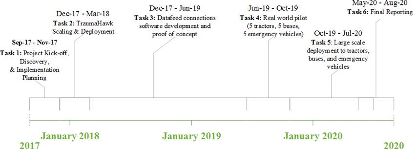
The following section outlines the REACH project's deployment plan. The team will execute a task-based approach to deploy the technologies described in Section 0 over a period of three years from the date of award. The task structure covers the deployment of REACH Part 1 (Rural Specialty Vehicles Hazard Alerting) and REACH Part 2 (Expanded Deployment of TraumaHawk Emergency Services Communications). These two parts will run in parallel throughout the project. Extensive software development on the front end of REACH Part 1 will mean actual deployment of the technology later in the project timeline (closer to Year 2). REACH Part 2 deployment will happen immediately (within six months of project start).
8.1 Tasks
Task 1: Project Kick-off, Discovery, and Implementation Planning
Task 1 will focus on finalizing the project timeline, identifying all critical stakeholders for REACH Part 1 and Part 2, and engaging those stakeholders to plan for the deployments for each part of the project. A kick-off meeting will also be scheduled.
REACH Part 1 stakeholder engagement will include formally identifying the tractors, school buses, and emergency vehicles that will receive the installation of the AVL devices and preparing for the data connection feed to the HERE© cloud by the UI and HERE© teams.
REACH Part 2 efforts under Task 1 will include identifying rural roadways and intersections to allow for strategic engagement of the first responder community in rural Iowa. The project will engage the first responder community and train them on the TraumaHawk app. The outcome of these efforts includes increasing the numbers of those trained on the app. Rural fire, paramedics, and the Iowa State Patrol would be included.
Task 2: TraumaHawk Scaling and Deployment

Task 2 will focus solely on the deployment of the smartphones to identified first responders serving primarily rural parts of the REACH project's geographic area. Activities under this task include procurement of the smartphones, set-up of the mobile app on the phones, any necessary backend software upgrades, field testing (to ensure the devices are working properly), and deployment and training to the identified first responders.
TraumaHawk has several training modules developed and ready for the TraumaHawk network. While new first responders always receive formal in-person training, the entire TraumaHawk network has access to several modules that can be viewed at any time. These modules include: step-by-step training on how to use the app; details about the anatomy of the car; importance of intrusion on injury; frontal collisions; side-impact collisions; rollovers; and the role A-pillar damage, toe pan intrusion, and steering wheel damage play in understanding injuries.
Program assessment is an important activity within this task. The TraumaHawk team currently debriefs following a TraumaHawk crash to assess the overall flow of the information and to identify crash patterns. The team will continue to hold these assessment meetings and maintain a database that correlates crash patterns to victim injuries, with the data being analyzed frequently. Qualitative assessments of the flow of information and the benefits of the report to the trauma center include the timing of the report and how the medical staff responded.
Finally, this task also includes frequent outreach throughout rural Iowa to first responders to discuss the benefits of the TraumaHawk mobile app and the impact it has for crash victims on rural roads.
Task 3: Data Connection Feeds Development and Proof-of-Concept
Task 3 will include assessment of the suitable AVL devices, design of the hazard alert, and completing the software development and programming to connect the AVL tractor, school bus, and emergency vehicle feeds to the HERE© data cloud. The UI already has experience connecting to the HERE© application program interface (API) and datafeeds. This institutional knowledge will expedite the connection of the vehicle feeds to the HERE© API and datafeeds. Testing and validation of the connection will be completed via a proof-of-concept with the UI's vehicles. The proof-of-concept will validate that the AVL device is successfully connected to the HERE© cloud and that the hazard alert is being furnished to a nearby driver in the scenarios and use cases the project team has prioritized. The outcome of this task will be a field-ready pilot deployment of the technology.
Figure 18. Task 3 Proof-of-Concept Process. The proof of concept confirms the successful AVL datafeed connection to the HERE Cloud and secondly, the alert to nearby drivers. The proof-of-concept will be completed in the UI's vehicles.
Task 4: Real World Pilot with 10 Tractors, 10 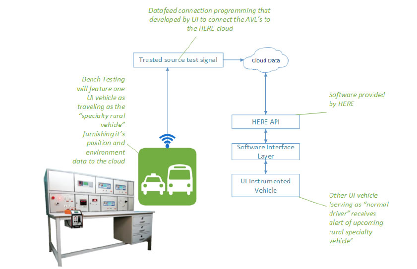 School Buses, and 10 Emergency Vehicles
Task 4 will deploy the AVL devices into 10 tractors, 10 school buses, and 10 emergency vehicles and connect them to the HERE© data cloud. Effort under this task includes testing the hazard alerting technology. The team will have the HERE© mobile app on smartphones and will test receiving alerts of an upcoming slowed or stopped tractor, school bus, or emergency vehicle with the piloted, AVL-equipped vehicles. This testing will ensure the software development datafeed connection is programmed successfully and supplies the real-time alerts as expected and is timely for drivers. During the pilot testing, the team will ensure the tractor and school bus alerts to drivers support these prior research recommendations.
Task 5: Large Scale Deployment to 70 Tractors, 70 School Buses, and 30 Emergency Vehicles
Upon successful testing of the piloted tractors, school buses, and emergency vehicles, AVLs and datafeed connections will be deployed into an additional 70 tractors, 70 school buses, and 30 emergency vehicles in the REACH project area. This task will also include significant outreach and engagement to rural residents to download the HERE© mobile app on their smartphones. Outreach efforts will include the motivation behind these efforts, showing that these alerts can save lives in the rural area by preventing a crash from occurring in the first place. Given the tight-knit nature of the rural community and the recognition of the dangers of rural driving, the team believes the rural community will be motivated to participate in the REACH program by the promise of the alerts to help save lives on our rural roads.
Task 6: Final Reporting
Task 6 will include all necessary federal reporting throughout the term of the project and the final report for the USDOT. The final report will capture all necessary information required by the funding, as well as lessons learned, benefits of the program, and the evaluative outcomes of deployment in the rural area. Evaluation assessment will include pre- and post-deployment crash statistics for the rural area, featuring those with tractor, school bus, and emergency secondary crashes in the REACH project area, as well as crashes with and without the TraumaHawk mobile app and the related trauma center ETA differences.
8.2 Long-term Operation and Maintenance
REACH enhances current collaborative projects between the UI and Iowa DOT, including the Automated Vehicle Technologies Project and TraumaHawk program. Efforts outlined in this proposal build on the these two already-established programs. Both programs rely on technology that has gone through significant requirements development, refinement, and pilot testing and validation. These programs have long-term visions and will be maintained by the original creators within the UI and Iowa DOT.
The UI and Iowa DOT see the hazard alerting technology as a method to mitigate crashes with specialty vehicles. The Iowa DOT will maintain the presence of the HERE© cloud platform and datafeeds and continue to work with HERE© to make necessary upgrades and enhancements as needed.
The UI, Iowa DOT, UI Hospitals and Clinics, and Iowa State Patrol troopers have experienced the great impact of the TraumaHawk program in Eastern Iowa and remain committed to collaboratively sustaining the program for the foreseeable future. The UI has the long-term responsibility of ensuring functionality of the software app. Both the UI and Iowa DOT have committed to expanding TraumaHawk throughout all of Iowa.
9 Partnership with Private Sector and Public Agencies
9.1 HERE©
As previously discussed, the Iowa DOT has an existing contract with HERE© to provide cloud-based mapping services for the Automated Vehicle Technologies Project. The contract provides data to support real-time traveler information. The UI is also a partner on this project. REACH will leverage this partnership and the new/existing technologies to efficiently carry-out Part 1 of the project.
9.2 State Agencies
The UI and Iowa DOT will partner with a variety of state agencies during the REACH project, including the Iowa Department of Education and the Iowa Department of Agriculture and Land Stewardship. These agencies will aid in communicating with the public, promotion of the REACH project, and addressing any challenges that may arise.
9.3 Agricultural Associations
The team recognizes that garnering support from the farming community is essential to REACH's success. While crashes involving tractors are not uncommon and there have recently been a number of high-profile fatal on-road crashes, some individuals may still be leery of permitting AVLs to be installed in their tractors. The REACH project team recognizes this challenge and has reached out to the Iowa Department of Agriculture, as well as organizations such as Iowa's Center for Agricultural Safety/Health (I-CASH) and the Johnson County Extension Service to build support and momentum for the program amongst farmers and agricultural cooperatives. Letters of support from these groups are provided in Appendix B. Additionally, the REACH team has worked with farm implement businesses on past projects and intends to reach out to these same individuals for support and guidance in contacting local farmers and identifying tractors frequently traveling rural roadways.
9.4 School Districts
Partnership with school districts will be a critical component of REACH Part 1 in deploying AVLs in school buses. Thirteen school districts are primarily located within Johnson and Linn counties alone, comprised of more than 51,000 students. Transportation services for these schools cover more than 2.6 million route miles every year. As a number of these schools are located almost exclusively within small town/rural areas, the initial REACH school bus AVL deployment would focus on reaching out to local schools within these two counties for participation in the program. Contact has already been made with a number of these school districts regarding the possibility of the REACH project; letters of support from the Iowa Department of Education and one of the schools that recently experienced a fatal crash are attached in Appendix B.
9.5 Law Enforcement and First Responders
As TraumaHawk is already deployed with a number of Iowa State Patrol troopers, the REACH project team has an established partnership with the law enforcement agency. In identifying what rural roads are the most dangerous and would therefore likely benefit most from TraumaHawk, the UI and Iowa DOT will work with law enforcement to determine which deputies to outfit with TraumaHawk smartphones. Additionally, the REACH team will potentially utilize this partnership to reach out to other first responder organizations in these areas as well (volunteer EMT organizations, fire departments, etc.).
10 Potential Regulatory, Legislative, Institutional, and Technology Challenges
In eastern Iowa and statewide, the Iowa DOT has committed to taking a proactive approach to preparing for increasing levels of vehicle automation. In recognizing the value of automated driving, the Iowa DOT has adopted an AV vision: To deliver a safe, reliable, and efficient transportation system by developing an AV-ready driving environment. Additionally, in conjunction with the Iowa City/Cedar Rapids Corridor AVPG, local governments in the REACH project area adopted proclamations welcoming the testing and operation of intelligent vehicles on area roadways. These government entities included the Johnson County Board of Supervisors, Linn County Board of Supervisors, City of Iowa City, and City of Cedar Rapids.
While the UI and Iowa DOT have generally seen support for developing an AV-ready driving environment within the state, the REACH project team recognizes challenges could arise at any time. Potential obstacles that may arise during the project's timeline have been considered by the REACH project team are discussed below.
10.1 Regulatory and Legislative Challenges
Though not anticipated, the REACH project team understands that regulations and legislation could always arise that hinders free development or use of these technologies. The REACH project team is comprised of a number of individuals who are highly-respected in the state's transportation community, as well as by legislators. Their expertise and connections will greatly help to mitigate the risks associated with new regulations that may arise at the state level.
As has been communicated with Iowa's Automated Vehicle Technologies Project, early, clear, and on-going interaction with policy-makers and the general public is critical to our success. The Iowa DOT's Automated Vehicle Technologies Project includes various outreach and education plans to the public and critical stakeholders to introduce the project, its purpose, and its implications for Iowans. This summer, the UI and Iowa DOT are reaching out to and meeting with local leaders and those in local and state governments to discuss Iowa's AVPG, as well as the future of automated and connected vehicle technologies in our state.
10.2 Institutional Challenges
The REACH project team recognizes that some farmers may be apprehensive to installing AVLs in their tractors. Additionally, some members of the community might be resistant to downloading the app. The UI has experience in marketing and educational campaigns related to vehicle safety education. Building on the lessons learned from prior experiences, the UI will carefully craft an innovative community outreach plan to ensure the success of REACH Part 1.
The TraumaHawk app is only beneficial if first responders use it. The REACH project team acknowledges this challenge and is committed to working with first responders on training and promoting the potentially life-saving benefits of the program.
10.3 Technology Challenges
The HERE© mobile app is being specifically developed for the state of Iowa's needs and priorities. Additional software functionality or development will be required to connect the tractor, school bus, and emergency vehicle AVL feeds to the HERE© cloud. There may be unforeseen technical issues or difficulties that arise during the initial connection and development. However, UI and Iowa DOT staff have been working on the connection of several datafeeds to the HERE© cloud and have a firm understanding of the underlying system architecture. Additionally, HERE© has significant experience in connecting with various types of feeds and it is part of their long-term plan with the Iowa DOT to connect several types of mobile vehicles with their Iowa datafeed cloud. HERE© will serve as a valuable resource to the UI team as datafeed connection issues arise.
TraumaHawk is a proven technology that is constantly being updated. On the Apple beta testing system, new releases are required every 30 to 60 days. Since July 2015, the TraumaHawk app has required 13 of these updates. The TraumaHawk team is committed to providing additional updates to ensure that the TraumaHawk app continues to function properly. Two additional updates have been issued to ensure maximum benefit: sample reports allowing for identification of potential bugs in the app and administrative text alerts allowing for communication between the ED and first responder. With an expanded deployment, new issues may arise, and the team is committed to continued monitoring of the program, with app updates issued as needed.
11 Plan to Leverage and Optimize Existing Local and Regional Advanced Transportation Technology Investments
11.1 High-definition Mapping Integration
The Automated Vehicle Technologies Project is a partnership between the UI and Iowa DOT, aimed at addressing some of the key safety and mobility challenges and opportunities facing Iowa. Part of this project is to identify the enabling technologies and strategies for support, testing, and phased deployment. These technologies feature a high-definition map of the project area with real-time traffic data, vehicle-to-everything (V2X) messaging platform, and predictive models.
The Iowa DOT has entered into a multi-phased project with HERE© to collect traffic data and develop a platform to enable higher levels of vehicle automation. The platform features three layers: the high definition map, the driving environment layer (also referred to as the location cloud), and the analytics layer. The first step in this project has been configuring the location cloud service in the defined project area. The project area for the Iowa DOT Automated Vehicle Technologies Project is within the geographic project area for this proposal. The project team has identified various traffic data that feeds into the location cloud. These feeds include traffic flow, on-road probes, weather, construction, and other Iowa DOT feeds. These feeds allow the ability to issue timely and critical alerts to the driver of upcoming roadway conditions. The second step in the project is the high-definition mapping of Interstate 380 between Iowa City and Cedar Rapids. The first batch of high-definition map data will be collected and made available in 2018 with additional mapping delivered as the project progresses. The high-definition map will be a representation of the physical road network with increasing level of accuracy and details provided over time. The final layer of the project features the analytics layer. In the future, this layer will enable automated driving by developing a "humanized" driving style for each stretch of road.
The REACH project will directly leverage the HERE© location cloud service and high-definition map service. At the time of this application, the Iowa DOT and UI are working with HERE© to pilot test the mobile app designed specifically for the State of Iowa. A description of UI's current efforts with the Iowa DOT may be found here. The efforts under the REACH project will establish datafeeds connections for tractors, school buses, and emergency vehicles to the HERE© location cloud. This datafeed connection allows the ability to route to the HERE© location cloud, and thus alert drivers to these specialty vehicles in the rural area.
11.2 Existing AVL Integration
As mentioned in Section 0, some school buses and emergency vehicles within the REACH project area may already be equipped with the necessary AVL technology. For these cases, rather than installing new devices, the REACH project team will make every effort to leverage the existing AVL technology and it's datafeed. The UI will evaluate the feasibility of connecting these existing devices' datafeeds to the HERE© cloud.
11.3 Iowa AVPG
In 2016, the USDOT designated the Iowa City/Cedar Rapids Interstate 380 corridor as one of the ten AVPG pilot sites in the nation. Proving grounds designations are meant to foster innovations for transforming personal and commercial mobility, expanding capacity, and opening new doors to disadvantaged people and communities. The Iowa AVPG was able to demonstrate that it has a variety of different facilities that can be used to gauge safety, manage various roadways and conditions, and handle various types of vehicles. Other criteria for selection included demonstrating capable safety planning, willingness and ability to share and disseminate information, and an ability to show that all applicable laws, regulations and policies are adhered to at all times. Work is underway for the Iowa AVPG, with leaders from the UI, Iowa City Area Development Group, local municipalities and governments, organizations, and technology-focused companies meeting to determine the vision and goals of the AVPG. As investments and progress made in the Iowa AVPG will likely be complementary to the REACH project, these efforts will be leveraged for the REACH project.
12 Support or Leveraging of the ITS Program or Innovative Technology Initiatives
In alignment with the ITS 2015-2019 Strategic Plan themes, REACH enables safer vehicles and roadways, promotes innovation, and supports transportation system information sharing. REACH also aligns with a number of ITS innovative technology initiatives, including connected vehicles, emerging capabilities, and accelerating deployment.
REACH Part 1 supports the USDOT's connected vehicles program. Working in cooperation with state and local transportation agencies, school districts, medical entities, the public, and others, REACH will deploy AVL technology into tractors, school buses, and emergency vehicles to facilitate connected vehicle safety applications. REACH supports interoperability, increasing the efficiency of communications and information sharing between transportation agencies and users.
The REACH project also brings emerging technologies to the rural areas. In particular, TraumaHawk (REACH Part 2) has innovatively established a new way to use technology to address issues hospital trauma teams face, such as little advanced notice of crash victim arrival and potential lack of information about a crash. With a simple, targeted app, first responders are able to address these issues, improving patient outcomes and potentially saving lives.
The REACH project supports accelerating the deployment of new technologies, particularly to new segments of the population. Most deployment of these advanced technologies to date have focused on the urban environment. By extending the technologies to rural areas with safety as the primary goal, the REACH team hopes this will encourage increased awareness, understanding, and acceptance of these technologies. As is noted in the ITS 2015-2019 Strategic Plan, while rural ITS is not a new area, there are deployment challenges in rural environments. The REACH project provides an incremental step for rural roadway travelers toward connected and automated vehicle technology adoption. REACH addresses salient, profound issues rural residents are deeply concerned with, including the safety of their children while driving on roads and riding school buses, as well as their own safety while driving farm equipment.
13 Schedule
14 Deliverables
| Deliverable | Approximate Due Date | Section 508 Compliant? |
|---|---|---|
| Year 1 | ||
| Task 1: Project Kick-off, Discovery and Implementation | ||
|
Within 4 weeks after award | No |
| Deliverable: Monthly Progress Reports* | Monthly | No |
| Deliverable: Report to Secretary** | Annually beginning one year after award | Yes |
| Task 2: TraumaHawk Scaling and Deployment | ||
|
Jan 2018 | No |
|
March 2018 | No |
| Task 3: Datafeed connection's software development and proof of concept | ||
|
June 2018 | No |
|
June 2018 | No |
| Year 2 | ||
|
Feb 2019 | No |
|
June 2019 | No |
| Task 4: Real world pilot (10 tractors, 10 school buses, 10 emergency vehicles) | ||
|
June 2019 | No |
|
August 2019 | No |
| Year 3 | ||
|
Nov 2019 | No |
| Task 5: Large scale deployment to tractors, school buses, and emergency vehicles | ||
|
Dec 2019 | No |
|
April 2020 | No |
| Task 6: Final Report | ||
|
Sept 2020 | Yes |
*Monthly progress reports will be submitted to document activities performed, anticipated activities, and any changes to schedule or anticipated issues
**Annual reports will be submitted to the USDOT Secretary describing the deployment and operational costs compared to the benefits and savings, and how the project has met the original expectations projected in the deployment plan.
15 Staffing Description
Redacted (1 and ½ pages)
The primary point of contact for the project is:
Prof. Daniel V. McGehee, Ph.D.
Director
National Advanced Driving Simulator
The University of Iowa
College of Engineering
2401 Oakdale Boulevard
Iowa City, IA 52242-5003
Phone: 319-335-6819
Email: daniel-mcgehee@uiowa.edu
Redacted (1 page)