Advanced Transportation and Congestion Management Technologies Deployment Initiatives (ATCMTD) - Improving the Safety and Connectivity of Four Detroit Neighborhoods: Volume 1 - Technical Application
Project Description
1. Introduction
Through this grant, the City of Detroit proposes to partner with the Michigan Department of Transportation, the Southeast Michigan Council of Governments, Wayne State University and Argonne National Laboratories to reduce traffic-related fatalities and injuries, optimize multi-modal system performance, improve access to real-time integrated multimodal transportation information, and enable access to this information across the digital divide.
Mobility matters, not just as a way to move people and goods, but because it shapes places, access to opportunity, and quality of life. Changes in modern transportation policy, funding, and research, have made significant impacts, however Americans are still 7.2 times more likely to die as a pedestrian (based on data collected from 2005-2014) than from a natural disaster1. Simultaneously, mobility options and technologies are rapidly changing, creating new avenues to reduce risk across transportation modes, expanding the suite of potential strategies for delivering mobility as a service, and helping to mitigate transportation barriers to opportunity and quality of life.
Detroit, like many other U.S. cities, has a complicated and challenging transportation landscape. The legacy of aging infrastructure, transportation systems built for the density and needs of a different era, and a population with high expectations for service delivery combine to make change financially, socially and politically tricky. Over the last three years under the leadership of Mayor Duggan, Detroit has begun to climb out of an historical low point. From provision of basic services, like getting the lights on or reducing EMS response times, to more challenging multi-partner initiatives intended to spark new development and investment, conditions are improving quickly. For transportation, initial investments in expanding the city's bus fleet, launching 24-hour service along nine routes, initiating a new bike-share program, and establishing the first light rail service along Woodward Avenue, have been transformative. In spite of these efforts just getting around the City continues to be challenge for many residents.
Two fundamental transportation-related concerns must be addressed in Detroit to keep the city moving forward:
- Safety. Detroit's fatal crash rate of 19.20 persons per 100,000 population is the highest rate among the 35 most populous cities in the country and 23% higher than the city with the second highest rate (Memphis). There are numerous potential causes for this, from overbuilt streets promoting speeding to the inability to enforce red-light and speed violations using cameras to something else. The City's most vulnerable users, pedestrians, are most at risk and make up over ⅓ of fatalities. If people don't feel safe walking, they won't feel safe taking transit or riding a bike. This is a huge obstacle for improving all modes of mobility.
This grant proposes to address this issue by installing communications and detection infrastructure at intersections to support the development and deployment of innovative applications for detecting different types of pedestrians, identifying and predicting unsafe driver behavior, and creating V2I applications around safety.
- Connectivity. Public transportation in Detroit suffered a precipitous decline in resources and human capital, mimicking the City's plummeting population numbers. In 2003, Detroit's transit agency, the Detroit Department of Transportation (DDOT) provided 1,607,672 revenue hours. Thirteen years later, this number had been reduced by over 55%. Over the last three years, population loss has slowed to a trickle, and based on local electric turn-on rates we anticipate the first true population growth next year. The residents and businesses that have stayed in Detroit and the new residents and businesses flocking in are scattered across the City's 139 square mile footprint. Efforts to leapfrog from old infrastructure to modern mobility strategies to resolve this problem have been stymied by a lack of data, data capacity, and the digital divide. Approximately 40% of Detroit residents do not have access to the internet, radically limiting the impact of digital solutions. Based on conversations and Potential autonomous and connected vehicle strategies require data connectivity, capacity and networking at a potential rate of 4TB per vehicle, while currently Detroit lacks sufficient capacity to accommodate the average 5MB per day the average person currently uses across the country2.
Detroit is currently working on a multi-year effort to develop a new transit service plan that will focus on providing frequent fixed-route service on the major corridors in the City and developing innovative solutions to serve low-density areas of Detroit, correcting the structural transportation barriers created by past disinvestment. This service plan must address the digital divide in the City, to ensure full penetration and impact of proposed mobility options.
The solution described in this proposal is fundamental to this larger effort. Through this grant we intend to provide more public information to transit users, by providing free wi-fi to transit passengers in an efficient manner, as well as develop an application to help aggregate the supply of private transit and demand of transit needs of people in Detroit.
Additionally, our proposal includes the application of a mesh network solution in the four deployment areas. The intent of this solution will be to provide free wi-fi to all residents in the area, addressing the challenging digital divide in Detroit, as well as create a backbone for connected and autonomous vehicle data communications in V2I and V2V applications to support not just current data capacity needs but future per person and per vehicle projected needs.
The mobility challenges faced by Detroiters are not unique to our city. There are so many places across the US where things like lack of information of upcoming transit or not feeling safe crossing the street to the bus make people's lives more difficult. Detroit, however, is uniquely positioned as a test lab for solving these issues because while the challenges are shared, they are uniquely deep and uniquely entrenched in Detroit; simultaneously the City's relatively recent bankruptcy and population challenges have required Detroit to be uniquely ambitious and open to the risk-taking needed to court industry partners and pursue innovative solutions. Through this funding, the FHWA can materially assist not just Detroit, but effectively demonstrate how to deploy new technologies to transform sprawling cities with aging infrastructure and significantly impoverished populations into safer, more connected communities where all residents are provided the mobility access they need and deserve.
2. Entity to Receive Funding
About the City of Detroit
The task of improving mobility in Detroit is shared by a number of departments that all report to the Mayor, including the Office of Mobility Innovation, the Department of Public Works, the Department of Planning and Development, the Department of Innovation and Technology, and the Department of Transportation (public transit). The roles of each department as part of this grant are listed below.
Office of Mobility Innovation
The Office of Mobility Innovation (OMI) will serve as the lead department of the City of Detroit. OMI is responsible for making it easier to get around Detroit and works daily to support all of the city departments tasked with improving mobility.Department of Public Works
The Department of Public Works (DPW) manages Detroit's public right-of-way and includes the City's traffic engineering group. This team has developed the initial vision for improving traffic signal operations, including installing cutting edge solutions at 88 of the City's intersections. The traffic group will lead much of the implementation of this grant.Department of Transportation
The Detroit Department of Transportation manages the City's bus fleet and operations. DDOT has made numerous improvements over the last year, including restoring 24-hour service to the City and increasing frequency on a number of routes.Department of Innovation and Technology
The City's Department of Innovation and Technology (DoIT) is tasked with developing strategies around technology, data, and communications.
Partner Membership
The City of Detroit is excited by the partnerships that have been developed as part of the OMI. We are submitting this grant with the full support of the Michigan Department of Transportation and the Southeast Michigan Council of Governments, and both will play roles in implementation of the grant. Our academic partners are Wayne State University and Argonne National Laboratories. A number of private sector partners will be instrumental in developing the ideas that follow and will be part of implementation.
Michigan Department of Transportation
MDOT is the nation's leader in the deployment of connected technology, with over 350 miles of freeways and arterials planned to be equipped by 2019. Applications to date include red light warnings, work zone/warning management, road weather management, and pavement condition.
Wayne State University
Wayne State University, Civil and Environmental Engineering, is partnering with the City of Detroit to conduct an evaluation of the project. Wayne State's focus will be on:
- Building new V2I applications
- Performance measurement
- Developing new teaching and educational opportunities around transportation technology
- Open data applications
Argonne National Laboratory
Argonne National Laboratory is currently working with the City of Detroit on a pilot deployment of the Array of Things, an "urban sensing" instrument, measuring data on cities' environment, infrastructure and activity in order to scientifically investigate solutions to urban challenges ranging from air quality to urban flooding. As part of this ATCMTD program, Argonne will expand the Array of Things to the four neighborhoods proposed as part of this study and will lead the work around video analytics.
Project Management
This project will be managed under the leadership of Mark de la Vergne, Chief of Mobility Innovation. He will coordinate an internal project group including staff from the Department of Public Works, Department of Planning and Development, and the Detroit Department of Transportation and meet on a weekly basis to review progress.
Grants Accounting and the Office of Grants Management will assist in the management of project funding. These two entities under the Chief Financial Officer are responsible and have personnel and infrastructure in place to manage federally-funded procurement processes, and ensure compliance with all federal accounting and reporting requirements.
3. Deployment Location
The proposed project will take place in the City of Detroit, and deployment will be targeted in four neighborhood areas: Southwest Detroit, the Riverfront, Corktown, and Livernois-McNichols. This distribution is representative of a broad range of demographics and condition with respect to mobility, and this diversity will help to ensure that the developed solutions are sufficiently robust and responsive to a variety of existing concerns.
Detroit is roughly the size of Philadelphia, with half the population (just under 700,000 per the last census estimate), as a result of over fifty years of continuous population loss and disinvestment. Approximately 40% of the population survives on less than $20,000 in annual income and more than a third of properties have been foreclosed in the last decade. Literacy and numeracy are very real challenges in the city, with 80% of schools having opened, closed, or both, in the last two years. Public health issues such as teen pregnancy, rates of asthma, and trauma related to violence are out of scale with any other city Detroit's size, and public safety issues such as homicide and violent crime rates are notoriously off the charts relative to national averages. This history has left individuals and families isolated in neighborhoods with few resources and even less hope.
While each of the proposed locations for this project has unique characteristics3, they are all a part of Mayor Duggan's vision for strategic neighborhoods investment in Detroit. They have been selected for investment because they are tipping point neighborhoods, with relatively stable populations and conditions that are positive for economic growth and resident attraction, and as a result they are being targeted through other public and private funding for multi-family housing development, entrepreneurship support, enhancement of public good infrastructure such as pedestrian lighting, park and streetscape improvements, and other service enhancements. Deploying mobility solutions in these areas will help to ensure that current residents within and surrounding these areas have the opportunity to participate in the renaissance of the City, and that both current and new residents can access the wealth of assets and resources that are scattered across the City.
The goal of this proposal is to leverage the investments that Detroit is making in these four target neighborhoods, from traditional public works to social infrastructure, in order to model mobility solutions that integrate high traffic corridor solutions with neighborhood solutions that allow current residents mobility access that is equitable with the access of new arrivals who may be more digitally savvy. We believe that this set of conditions and need to scale is present in cities across the U.S. and that projects once piloted here will find clear applications in places like Atlanta, Orlando, Memphis, and throughout the Rustbelt and Sunbelt, where a dispersed, impoverished, and often auto-reliant population requires mobility access.
Demonstration Location #1: Southwest Detroit, including Vernor E Corridor from Woodmere to Fisher Fwy Ser Drs
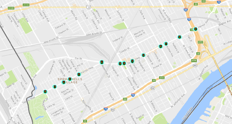
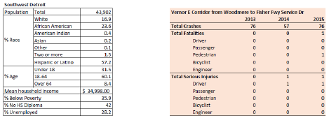
Southwest Detroit is one of the first three neighborhoods in the City targeted through the Strategic Neighborhood Fund to invest in multi-family housing, public infrastructure improvements and comprehensive stabilization efforts. These areas have been identified as communities at an economic tipping point, with population levels, housing stock and commercial corridors well-suited for investment and presenting the best opportunity for success. They share key strengths on which to build - a larger percent of the civilian labor force employed, lower poverty rates, and less overall population loss post 2008, then Detroit as a whole - and key challenges, namely the lack of concentrated commercial and retail density, and deteriorating public amenities. The population of this neighborhood is growing, and population density is relatively high for the city.
From a transportation perspective there are a number of additional challenges. The target corridor is 23' on both sides, with 2 vehicle lanes in each direction, and 14 signals. The traffic signals along the corridor currently have no communications capabilities, and the City relies on public reporting of issues such as signal outages. This lack of connection also means that signals are not coordinated or synced, causing unnecessary delays, and unpredictability for pedestrians and bicyclists.
Demonstration Location #2: East Riverfront (Jefferson E Corridor from Chrysler Fwy to Alter)
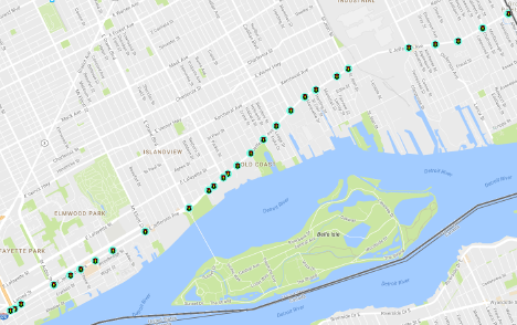
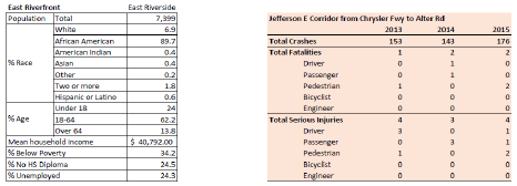
The target corridor in East Riverfront (called East Riverside by Data Driven Detroit) is the major commuter arterial route from Downtown to Grosse Pointe, and currently has up to 9 lanes of traffic for significant stretches. When I-94 becomes congested, drivers divert to this arterial route causing high traffic volume during peak periods. Generally speaking, the north/south bound cross streets are narrow and carry limited traffic, and the majority of drivers are making left or right hand turns from these streets onto the arterial rather than traveling straight through the intersection. Like Southwest, the 28 signals along this route have no communications capability currently. There is also no automated pedestrian crossing allocation, and pedestrian crossing relies on push button technology which may also malfunction and require public reporting for the City to become aware of repair needs. Car speeds along this corridor are very high because drivers anticipate straight green lights. There are currently plans underway to add a bike lane to each side of the arterial road, potentially increasing congestion. Integrating strategies to optimize green light time, while serving side streets and pedestrians safely, and accommodating growing number of bicyclists will be key for success in this neighborhood. There is also significant and growing number of commercial activities along this corridor, which rely on driveways and parking lanes that require gaps in traffic to serve customers.
Demonstration Location #3: Corktown (Michigan Avenue Corridor from I-96 Fwy to Campus Martius)
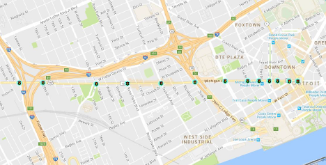
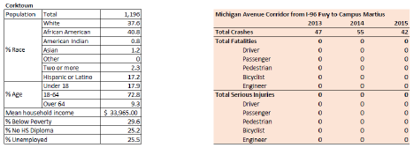
The target corridor in the Corktown area is a state owned road, with three signals under city control. Again signals along this roadway have no communication capabilities. Similar to East Riverfront, this corridor is a high speed arterial with a heavy traffic load at peak times, however this roadway has two freeway exits and entrances as well as several major cross street. This arterial also has only two lanes of traffic in each direction; the state installed a protected bike lane recently, and there is parking allowed on both sides of the street. While the total crash number is lower for this area, it has in recent years developed a bustling stretch of businesses and restaurants which increase the pedestrian traffic and risk of conflict.
Demonstration Location #4: Livernois McNichols (including Livernois Avenue Corridor from 8-Mile Road to Puritan)
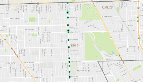
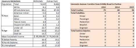
Like Southwest, Livernois-McNichols (divided into McNichols and Palmer Park by Data Driven Detroit) is a target of the Strategic Neighborhood Fund, and has attracted robust funding and interest via a $10M "Re-imagining the Civic Commons" grant to repurpose city-owned vacant land to support neighborhood revitalization and development. The target corridor in this location runs to 8-mile Rd, which is the northern border of Detroit, and provides multi-modal commuter connection to the surrounding cities and suburbs. This corridor also crosses multiple freeways, a railway, and has high levels of commercial activity; it also passes between two academic institutions - University of Detroit-Mercy and Marygrove College - creating significant student traffic and campus-related vehicular movement, as well as a need to manage special event traffic (sports, conferences, etc). It currently has two moving lanes and one parking lane in each direction, as well as a 22' median. There are 13 traffic signals along this corridor.
4. Real World Issues and Challenges Addressed
| Challenge | Technology Deployment |
|---|---|
| Detroit's fatal crash rate of 19.20 persons per 100,000 population is the highest rate among the 35 most populous cities in the country and 23% higher than the city with the second highest rate (Memphis). The City's most vulnerable users, pedestrians, are most at risk. Detroit's pedestrian fatality rate is and make up over ⅓ of fatalities. | Video cameras and analyzers at intersections for detection and analytics, DSRC and cell communications, Array of Things sensors, in-vehicle sensors and communication devices |
| Technology Focus Areas | |
|
|
| Addresses ATCMTD Goals | |
|
|
| Challenge | Technology Deployment |
| In 2003, Detroit's transit agency, the Detroit Department of Transportation (DDOT) provided 1,607,672 revenue hours. Thirteen years later, this number had been reduced by over 55%. This cut in service obviously had significant impacts on ridership and people's overall mobility. While Mayor Duggan and DDOT have stabilized service and improved operations, much more has to be done to improve transit. The City is currently working on a multi-year effort to develop a new transit service plan that will focus on providing frequent fixed-route service on the major corridors in the City and developing innovative solutions to serve low-density areas of Detroit. One of the main challenges of this task is determine how to create new solutions for those residents that don't have access to the internet, which is approximately 40% of the population. |
|
| Technology Focus Areas | |
|
|
| Addresses ATCMTD Goals | |
|
|
5. Transportation Systems and Services
The proposed project will deploy advanced transportation and congestion management technologies to improve safety at intersections, improve connectivity for our residents, and increase the capacity for data communications. The project will be deployed in four diverse neighborhoods in Detroit, all of which are part of the Mayor's strategic neighborhood improvement strategy. It will address a number of the causes that have made mobility a barrier to opportunity and a basic quality of life issue for so many residents in Detroit.
Intersection Safety:
- Video Detection and Analytics: A video camera is required at lower levels of the ITS solution stack for remote intersections monitoring. The same piece of equipment will bring more sophisticated benefits by also providing video detection and analysis. The hardware will be a durable, high resolution video traffic camera proven in all weather conditions, with high sensitivity to ensure accurate vehicle detection at night. It will be optimized for detection, an essential element of advanced traffic signal performance measures and network optimization. The camera will create a complete video vehicle detection system that eliminates the need for Detroit to install other detection technologies like radar or inductive loop. The ITS applications enabled include intersection control, incident detection, traffic counts and classification studies, as well as surveillance applications. Based off of the video footage, the team will work on developing new applications to detect different types of pedestrians and vehicles and build analytic cases around safety issues beyond reported incidents.
- Sensors: The City of Detroit is about to undertake a pilot project with Argonne National Laboratory's on the Array of Things, where a network of interactive, modular sensor boxes are installed collecting real-time data on the city's environment, infrastructure, and activity. This data will be used both around the analytics portion of the project as well as the V2I communications.
- V2I communications: Detroit will install the largest public test-bed of V2I connectivity in the country along four corridors and 66 intersections. The V2I solution requires a DSRC roadside unit (RSU), which will be an integrated solution within the traffic signal equipment. The RSU includes DSRC cabling in the antenna and a processing unit in the smartlink to connect information from separate ITS, traffic lights, and weather or road detection with cars, buses, freight trucks, emergency vehicles. The solution also connects roadside equipment including video cameras and lights, and personal mobile devices - making streets and highways safer and even the busiest corridors more efficient. Initially, the V2I software will communicate basic safety messages (BSM), construction warnings, and Signal Phasing and Timing (SPaT). As partners work with Detroit's test corridors, custom safety, weather, environment or efficiency messages will emerge and be integrated into the communications cycle.
- Vehicle pre-emption: The traffic signal upgrades will provide the opportunity to provide improved pre-emption for emergency vehicles and allow for transit signal priority along these four routes.
Connectivity:
- Mobility Application: A tool will be developed that allows people use to connect with mobility services that meet their specific needs, focusing on the needs of low- to moderate-income city residents. Social profiles will be used to match riders, providers, and destinations (e.g., a free roundtrip shuttle bus to Walmart) in three steps:
- A rider creates a social profile on Caravan and enters their trip request details.
- The rider sees a list of providers who can satisfy the request, including peer-to-peer ridesharing, carsharing, walking or taking the bus with a neighbor, or using a government or private service.
- The rider connects with the preferred service via contact information listed in the provider profile.
Residents' barriers to mobility innovation will be overcome via: A website accessible via home internet connection, smartphone, or at a community center; accepting cash payment; and using social profiles to build trust between riders and providers:
- Digital Kiosks: The City will deploy digital kiosks to offer real-time information on all mobility services (bus arrival, bike share and car share availability, TNCs), as well as additional local community information. This will provide critical information to those without access to the internet or a smart phone.
Mesh Network:
- DSRC: Install DSRC at 66 intersections to serve as communications backbone along the four corridors.
- IoT Gateway: The solution will provide an Internet-of-Things backbone for the city. All transportation data collected through this managed service is open data by default, and provides an Application Program Interface (API) with standard protocols and tools to allow entrepreneurs, citizens and the city to build software applications. All data from the traffic signals owned and controlled by the city to maximize the use and benefit of the solution beyond transportation. Other departments including transit, emergency services, public works, economic development, tourism, education, etc. will be able to access, merge, compare and share all datasets
- Install communications platform in buses on bus routes (25, 30, 37, 49) and fleet management vehicles in the area.
- Focus testing of autonomous and connected vehicles in these four areas to see how much data is being used.
6. Deployment Plan
Over the 36 months of the proposed grant period, the City of Detroit intends to deploy the following solutions for intersection safety, connectivity, and mesh networking, in conjunction with its partners.
Detroit is committed to making fiscally responsible decisions while moving its transportation infrastructure into the 21st century. This means augmenting existing equipment by integrating new ITS solutions, rather than replacing it. Detroit will install advanced transportation technologies that integrate with legacy controllers and equipment, that normally have to be replaced as part of a connectivity project. By modernizing legacy equipment with new ITS devices, the lifetime value of existing equipment is extended. Integration also minimizes the need for new staff training for support of the devices.
Detroit has identified ITS devices that ensure technical compatibility - even between analog and digital systems. Depending on the type of controller and intersection cabinet equipment that exists at each of the 66 deployments, if required, an interface device that uses either an ABCD adapter, or an SDLC adapter will be deployed. These devices also synchronize controllers through the network.
Streaming video from any existing Internet Protocol (IP) cameras will be integrated with the smartlink communications devices through the appropriate expansion port. Again, this takes advantage of investments that Detroit has already made in the signalized intersection network.
Detroit's traffic cabinet communications strategy will include a smartlink NEMA grade, ruggedized modem, industrial antenna with DSRC, managed switch, wi-fi traffic probe, backup battery, embedded security, time synchronization, video and data storage, and more. The robustness of such a system will serve the City's ITS needs now and into the future. Additional data will be fully encrypted and securely communicated via VPN. System administrators will control who can access various features and from where.
Traffic signaling networks often operate at the very edge of the network, and must perform reliably under tough environmental conditions. When an issue occurs, the traffic department can only respond if they are aware of the situation. Rugged smartlink hardware will be installed to connect signalized intersection infrastructure with Detroit's Traffic Management Center (TMC). This technology delivers video monitoring through a 4K 360-degree fisheye lens intersection camera and real-time signal information back to the TMC. This essentially does the fieldwork from the traffic management center so Detroit can spend less time collecting data, and more time using it to get issues cleared quickly. Real-time alerts, remote maintenance features, remote access to MMU logs and video monitoring will be delivered through a web-portal (available on desktop or mobile device) with unlimited licenses. This gives staff working at the TMC or in the field real-time access to information that will enable issues to be identified, diagnosed and sometimes resolved remotely, mitigating the number of expensive and dangerous field dispatches required to keep the traffic network in a state of good repair.
The detailed deployment plan is as follows:
7. Potential Challenges
The State of Michigan has been a leader in the regulatory and legislative environment with respect to connected and autonomous vehicles. It is not expected that there will be any issues with the state, but we anticipate that if there are any necessary future changes needed during the life of this grant, they would be supported by state elected officials.
With the rapid pace of technology and new types of vendors, there may be minor issues with regards to FHWA's Buy America provisions. The City of Detroit will adhere to the Buy America provision, but in the case that no domestic product is available, the City will notify FHWA and request a waiver.
The biggest potential challenge to the success of this project is social rather than technical. New technology adoption, particularly of mobile solutions and applications, is limited by the discrepancy in digital access and literacy of the potential population of users. In order to maximize success, the four neighborhoods in this grant are also targeted for other investments through the city, including traditional infrastructure, planning, new development, and other public and private resources.
Integration of the mobile application and free wi-fi capabilities along with these other sweeping investments will increase the likelihood of press coverage and word-of-mouth, as well as increasing confidence among potential users that concerns or issues will be heard and addressed. We believe that the technology deployments outline in this grant will directly enable the city to better manage signaling in key corridors thereby improving public safety and user experience in all transit modes, and that this improved experience combined with enabling free wi-fi provision will encourage rapid adoption of the proposed mobility application. Integrating further ITS advancements such as the mesh network will enable seamless growth of the system, and increased use will help Detroit address the broad suite of outcomes which mobility influences, including access to jobs, community health, and access to schools.
Another significant challenge this project, and society as a whole faces, is the pace at which
innovation occurs in the technology industry. "Future-proofing" infrastructure investments is difficult when all of the innovation is occurring in the private sector. Our approach to address this is to provide an open architecture system with our infrastructure that ensures flexibility in the case that we need to pivot with any technology strategy we have implemented.
8. Quantifiable system performance improvements,
The proposed project has the overall system performance improvements:
- Safety: The focus of this project is to improve safety at Detroit's intersections by improving the infrastructure and communications. This will be accomplished through advanced video detection and analytics and the development of a number of V2I applications focused on safety.
- Connectivity: The City's digital divide is one of the structural barriers that must be addressed to improve the ability for Detroiters to access opportunity. The 2 out of every 5 residents that do not have access to the internet are starting at a significant disadvantage. The connectivity deployments proposed as part of this effort will provide free wi-fi along corridors for any resident to use and connecting residents to existing private mobility services.
- Efficiency: The proposed project will allow transit and emergency vehicles to receive pre-emption at intersections. This will improve transit operations and reliability and reduce emergency response times.
- Environment: By reducing congestion, increasing transit usage, and reducing crashes, the project will reduce emissions, having a considerable impact on the air quality and environment in Detroit.
9. Quantifiable Benefit Projections
The proposed project will be evaluated through a number of different metrics. The list below includes the metrics for each measure and how we will go about evaluating them.
Safety:
- Reduction of intersection crashes by 20%. This will be evaluated over the three year period of implementation, comparing both the crashes year by year as well as the overall time period compared to the three-year time period before implementation.
- 1-2 minute improvement in emergency response time by enabling emergency vehicle preemption. We will track conduct a comprehensive before/after study of emergency response times in these four neighborhoods to evaluate the impact.
Connectivity:
- A 20% increase in internet users along the corridors. Qualitative studies will be conducted to evaluate this change.
Efficiency:
- Reduction of congestion and intersection delay by 30% through ongoing signal optimization and coordination. This will be evaluated through travel time data.
- Transit commute time improvements by 20% through enabling transit signal priority. This will be evaluated by travel time data of the buses.
- Improvement in traffic operations maintenance efficiency by 40% through remote monitoring, alerts, and diagnostics. This will be accomplished through in-vehicle communications platform as well as a review of existing operations.
Environment:
- A 3-5% reduction of GHG emissions related to excess fuel consumption, unsynchronized traffic signals, and intersection delay (1.25 - 2.6 million gallons of excess fuel saved). This will be modeled by Argonne and Wayne State to evaluate the environmental impact.
10. Vision, Goals, and Objectives
Detroit's vision for mobility is as follows:
Mobility supports Detroiters ability to access opportunity and other basic aspects of a quality life.
It is easy, safe, and affordable for people in Detroit to get to their destination and they have an abundance of options to do so.
Detroit has reestablished itself as a global leader in mobility and innovation in a manner that best serves those that live and work here.
Achieving this vision of mobility will require a fundamental transformation of how people and goods get around Detroit. This project's role will be fully integrating advanced technology, including smart traffic signals, advanced V2I, V2V, and V2P communications, and new applications to aggregate the supply and demand of transit in neighborhoods.
We strongly believe that this project not only addresses the existing issues in Detroit around safety and connectivity, but also sets the right framework for these corridors to serve as the backbone for the following elements:
- Autonomous vehicle applications
The City of Detroit is currently in discussions with a number of mobility industry companies on potential testing and commercial applications for autonomous vehicles. Both the infrastructure and communications plan included as part of this grant would help support these types of applications. - Data strategy
The amount of data that the City will be able to collect a significant amount of data from our deployment of smart and connected infrastructure. Our goal is to not only use this data for our own analysis, but understand the value of this data for private mobility companies and other interested parties so that we can build a citywide strategy. - Clear opportunities for private sector investment
By targeting our investment of advanced technology in four corridors and being clear with the goals and outcomes we are trying to achieve, it will assist other private companies of understanding where they should focus their efforts, both geographically and technically.
11. Partnership Plan
The City of Detroit is excited by the partnerships that have been developed as part of the OMI, which will be leveraged in the execution of this proposed project. We are submitting this grant with the full support of the Michigan Department of Transportation and the Southeast Michigan Council of Governments, and both will play roles in implementation of the grant. Our academic partners are Wayne State University and Argonne National Laboratories.
As part of the development of this grant, we have received a significant amount of interest from the private sector in partnering on this project. These partners include:
- Miovision (traffic signal technology)
- Robert Bosch LLC (connected technology)
- Veniam (mesh networks)
12. Leveraging and Optimizing Existing Investments
In the aftermath of the largest municipal bankruptcy in US history, Detroit is focused on sweeping, systemic change. For the first time in decades, the city is attracting new residents, new investors, and new development. We are steadfast in our commitment to ensuring that the city runs Smart, that we are engaging with 21st century solutions and that all Detroiters have the opportunity to participate and benefit. We are also committed to transforming the City while remaining fiscally responsible.
Through this application, the City of Detroit proposes to install advanced transportation technologies that integrate with legacy controllers and equipment, extending the lifetime value of existing equipment, while simplifying the training and support needed for system operation. This approach helps reduce waste, increases fiscal efficiency, and minimizes the risk of workforce overload or turnover that may have negative impacts on Detroit residents employed by the City in these roles.
Detroit has identified ITS devices that ensure technical compatibility - even between analog and digital systems. Depending on the type of controller and intersection cabinet equipment that exists at each of the 66 deployments, if required, an interface device that uses either an ABCD adapter, or an SDLC adapter will be deployed. These devices also synchronize controllers through the network.
Streaming video from any existing Internet Protocol (IP) cameras will be integrated with the smartlink communications devices through the appropriate expansion port. Again, this takes advantage of investments that Detroit has already made in the signalized intersection network.
Detroit has a wide array of existing assets to bring to the table, including: Miovision Spectrum hardware deployed at over 300 city intersections by July 2017; ten miles of private fiber network; over 100 live data feeds from Project Greenlight locations; an MOU with Argonne Labs to deploy 15-25 Array-of-Things sensors across the city this year; 65,000 connected LED streetlights with 7-pin connectors; and ten city built and managed radio towers. The City will be undertaking a study over the next year exploring best uses and practices of the ever growing array of smart technologies, maximizing their positive benefits for our residents and visitors, around these and other IoT devices that are currently in Detroit with a grant from the Knight Foundation. The results of this study will inform the overall data and communications strategies.
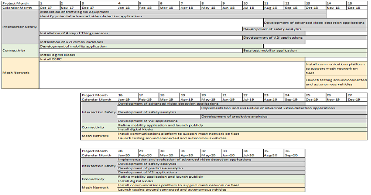
13. Schedule
The proposed schedule for this project's deployment and analysis is based on a 36 month timeline.
Intersection Safety:
|
Months 1-12 |
|
Months 1-12 |
|
Months 10-24 |
|
Months 20-36 |
|
Months 10-36 |
|
Months 20-36 |
|
Months 1-12 |
|
Months 10-36 |
|
Months 1-12 |
Connectivity:
|
Months 1-10 |
|
Months 10-16 |
|
Months 16-36 |
|
Months 1-36 |
Mesh Network:
|
Months 1-12 |
|
Months 12-36 |
|
Months 12-36 |
14. Support and Leveraging the ITS Program
The project will advance many of the current national ITS initiatives around connected infrastructure, automated vehicles, and data communications. The City of Detroit is committed to participating in the Michigan DOT's Data Use Analysis and Processing (DUAP) program, the first independent evaluation of the uses and benefits of the wealth of data generated through connected vehicle technologies. Many aspects of the project align with the priorities identified in the USDOT ITS Strategic Plan 2015-2019
1 Dangerous by Design 2016 [Return to Note 1]
2 http://www.networkworld.com/article/3147892/internet/one-autonomous-car-will-use-4000-gb-of-dataday.html [Return to Note 2]
3 Demographic information cited in the tables below was compiled and analyzed by Data Driven Detroit, and can be found by neighborhood name through the left side navigation here: http://www.cridata.org/Neighborhoods_Detroit.aspx?tmplt=D3. The crash, fatality and injury data was shared with us by the Southeast Michigan Council of Governments, and can be found graphically here: http://maps.semcog.org/crashlocations/ [Return to Note 3]