City of Dallas 2017 Advanced Transportation & Congestion Management Technologies Deployment Initiative: Volume 1 Technical Application
PROJECT NARRATIVE
1) Project Description
Introduction - To some extent the Intelligent Transportation Systems (ITS) industry is already connected - but in silos. The lack of standardization and a complex environment forces agencies and industry players to rely on limited sets of information, from a small set of sources. Releasing the potential confined in today's information silos requires a unified and agnostic ecosystem; a regional hub that enables all real-time data to interrelate, regardless of whether it comes from within one jurisdiction or from other sources. When traffic and road information is allowed to interact, i.e., when applications and data can be combined in a secure and trustworthy manner, it is possible to proactively deliver the right information to the right stakeholders. This will give cities and states a more efficient and sustainable urban environment with potential for a new range of digital services.
Traffic management is an example of a system that crosses jurisdictional boundaries as, for example, people and goods are transported along arterial roadways. In the transformation from city traffic management systems to regionally linked ITS systems, Information and Communications Technology (ICT) and secure communications investments designed to securely span jurisdictional boundaries are required.
The 16 counties that make up the North Central Texas Council of Government (NCTCOG) includes over ninety (90) agencies and/or jurisdictions with some level of responsibility for traffic management. Similar to many regions across the country, there is a growing need for coordination and data sharing among agencies related to operations, roadway safety, incident response, and travel time reliability.
In addition, the emerging connected vehicle market requires region wide signal phasing and timing (SPaT) data to provide real-time information to motorists. The accessibility of region wide SPaT data from a single cloud based portal rather rather than from each individual agency will greatly accelerate the dissemination of this data to motorists and generate significant safety and mobility benefits.
Yet another benefit of a regionally connected traffic management system is the opportunity to share high resolution and aggregated traffic controller data with other communities and research institutes. Data sharing with research organizations, for example provides the opportunity to analyze high resolution data, develop new operational tools to assist traffic engineers improve mobility, and/or provide an improved correlation between traffic data and air quality. Other uses will include sharing regional real-time data with external app developers and navigation providers, as well.
Use of ATCMTD Grant Funds - The ATCMTD grant funds will greatly accelerate the deployment of the System, and allow the North Central Texas Regional Smart Transportation System (NCTRSTS) to realize the expected benefits of a regional system through information sharing and coordination. Specifically, grant funds will be utilized for the following:
- Expand the system beyond the City of Dallas to include the Cities of Richardson and Irving, Texas.
- Provide funds to the Texas A&M Transportation Institute to conduct research using the high resolution data from the three cities which comprise almost 35 percent of the signalized intersections in the North Central Texas Region
- Develop operator interfaces to analyze performance of intersections and controller, estimate air-quality and mobility benefits, and create standardized data interface for other cities in the region joining the system.
- Support the collection and Dissemination of SPaT data from the largest jurisdictions in the region to a single cloud based portal to facilitate the expansion of connection vehicle technologies for the region. The 15 largest jurisdictions in the region account for approximately 75 percent of the signalized intersections in the region.
- Supplement the City of Dallas's implementation cost for the system.
- Support Operations and Maintenance of the system in Years 3 and 4.
2) Lead Applicant
The City of Dallas is the lead applicant for the duration of the project period. The City, in conjunction with other cities in the North Central Texas Region has developed a plan for the North Central Texas Regional Smart Transportation System (NCTRSTS). The system is ready to be deployed, and is envisioned as the next generation of advanced transportation management systems through its implementation of state-of-the-art web, cloud cellular, networking, open APL machine learning, and other controller technologies. The NCTRSTS is the safe choice for success in the deployment, operation, and evolution of the proposed technologies, including the proposed approaches to addressing any regulatory environment and other obstacles to deployment.
The Dallas-Fort Worth (DFW) area is already a leader in sharing traffic signal data to advance transportation objectives. An example of such a coordination is a multi-year initiative along the 30-mile US-75 corridor running through Dallas, Richardson and Plano, which was part of an Integrated Corridor Management project supported by USDOT. The pilot project included testing of response plans which included traffic signal coordination in response to roadway incidents adversely affecting traffic flow on U 75. Those efforts demonstrated value of cross-jurisdictional traffic signal coordination.
The City of Frisco has been a nationally-recognized leader in using traffic signal data to power connected vehicle applications. Frisco currently makes all of its traffic signal data accessible to a third-party that uses the data for such in-vehicle applications. Audi, for example, has done two demonstrations of its in-vehicle traffic signal application in Frisco and has indicated that Frisco will be one of the earliest cities where the application will be available. The City has provided a letter of support for this project.
Likewise, another DFW city, Arlington, has partnered with a different third party. It is sending its traffic signal data to this third party, which is optimizing the data for use by automakers for in-vehicle applications and to develop a smartphone app offering similar functionality. Arlington is testing the system now and expects to roll out public-facing applications in a matter of weeks.
The Regional Transportation Council (RTC) of the North Central Texas Council of Governments (NCTCOG), the transportation policymaking body for the DFW region, has recognized the importance of making traffic signal data accessible tot he developer community to power the development of connected vehicle and other applications using that data. In late 2016 the RTC endorsed the idea of making regional traffic signal data available. In April 2017 the RTC approved a $250,000 grant program to assist DFW cities in making their traffic signal data accessible.
In addition, for many years NCTCOG has provided substantial financial support to cities in the region for projects such as coordinated signal re-timings and traffic management center to traffic management center communication with respect to traffic signals. This demonstrated DFW regional commitment to improving traffic signal systems and extending their capabilities through connected vehicle and other applications makes DFW an ideal place to invest federal dollars in innovative traffic signal solutions.
Deployment partners - The City of Dallas is joined by these key partners in executing the project described in this application. These partners include the following entities:
- City of Irving
- City of Richardson
- North Central Texas Council of Governments (NCTCOG)
- Texas A&M Transportation Institute
As other Cities join the NCTRSTS, they will be included in the partner group. The City of Dallas has developed a governance framework for addressing regional operation policies and issues.
Project Management - The City of Dallas intends to execute Memorandums of Understanding (MOUs) will each partner agency to document roles and responsibilities of each agency. Each agency will have defined tasks and deliverables for their part of the program.
A critical component of the NCTRSTS is the ability to support regional transportation operational strategies by providing the ability to easily share traffic controller data between participating agencies using a cloud based repository.
These strategies include by are not limited to the following:
- Status information sharing between agencies
- Implementing and maintaining coordinated traffic plans across agency boundaries
- Coordinated multi-agency responses to incidents
- Real-time and off-line analysis of signal and cluster performance measures
- Support of third party applications for providing SPaT information to motorists
The City of Dallas has provided leadership in lowering the barriers for adjacent communities to engage in the regional traffic system. The City of Dallas has vetted a well thought through plan for deployment of the NCTRSTS and believes the Dallas System is a model deployment site for large scale installation and operation of advanced transportation technologies to improve safety, efficiency, system performance, and infrastructure return on investment.
Financial Management of the project funds will be done through the City of Dallas using the City's established protocols and accounting systems. The City also has extensive experience implementing grant funds, including those for transportation projects. The City of Dallas's most recently completed audit (period ending September 2015) illustrates that the City received and managed approximately $389,804,063 in competitive and formula federal awards, and $82,946,450.89 in state awards. The City has in place a grants management system that includes checks and balances, to ensure that grant funding received is segregated and tracked effectively and efficiently.
3) Geographic Area of Deployment
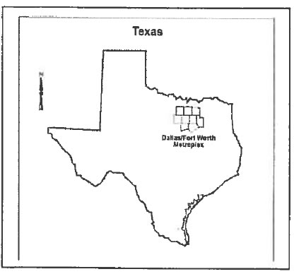
The North Central Texas Region is comprised of 10 counties. The NAFTA Corridor runs through Dallas (Interstate 35E) and through Ft. Worth (Interstate 35W). Both Interstate 20 and Interstate 30 run through Dallas and Fort Worth. DFW Airport is the third busiest airport in the world, bringing in goods and more than 29.97 million domestic visitors to the area annually. The proposed NCTRSTS's core service delivery will be in Collin, Dallas, Denton, and Tarrant Counties.
The Deployment of the NCTRSTS is intended to ultimately cover the entire 16 counties included in the NCTCOG region. The initial deployment will include the combined corporate limits of the Cities of Dallas, Irving, and Richardson. The geographic coverage area of the initial deployment is illustrated in the figure below and totals over 482.13 mi2, and includes approximately 1,800 signalized intersections.
It is relevant to issues of transportation congestion, to note that the City of Dallas, itself is currently home to 1.8 million people. New estimates from the U.S. Census Bureau (2015) indicate Tarrant, Collin, and Dallas Counties, alone welcomed the most new residents of any metro area in the U.S. The population of the Dallas-Fort Worth area jumped to 7,233,323 from July 2015 to July 2016. That's a one-year spike of 143,435 residents, putting Dallas-Fort Worth at No. 1 for growth in the U.S. in terms of sheer numbers, rather than percentage. In other words, the DFW area added 393 residents each day.
Dallas County added 29,209 residents during the one-year span to wind up with a population of 2,574,984 (July 2016 U.S. Census Bureau estimates). Tarrant County grew even more, gaining 35,462 residents and landing at a population of 2,016,872.
In terms of traffic, The Dallas Morning News (March 2013) stated that more than 507,397 people are moving into and out of the DFW area on a daily basis. The majority originate in the suburban cities of Frisco, McKinney, Irving, Plano, Denton, Garland, Carrolton, Richardson, Mesquite and Allen, with an average one-way commute within Dallas County of 25.8 minutes. Although, the DFW area is configured into numerous business communities and centers, some commutes go into the suburban communities away from city centers, making the movement of vehicles a constant for traffic control observation and mitigation.
4) Real World Issues
The real world issues and challenges to be addressed by NCTRSTS are traffic congestion that increases emissions by adding vehicle hours on highways and thoroughfares, in addition to the energy consumption surges and efficiencies that are lost. But NCTRSTS proposes a wide-angle approach to these issues by bolstering regional transportation operational strategies that are enabled through the implementation of a private "cloud":
The cloud that hosts NCTRSTS will provide a framework for sharing and utilizing traffic signal data with other agencies, regional planning organizations, public safety, and/or third party domains (e.g. connected and autonomous vehicle systems, academic organizations, or app developers). The availability of regional data through a single cloud-based portal provides aggregation and distribution of real time data and video, high resolution controller data, and (SPaT) provides multiple benefits for the region, including the following:
- Gives an opportunity to address arterial traffic congestion on a regional corridor basis rather than by individual cities.
- Allows dissemination of data between agencies for improved coordination on traffic operation strategies.
- Provides regional data to planning organizations or academia for analysis and/or research.
- Provides regional SPaT data to auto makers for the deployment of connected vehicle technologies.
- Provides the necessary regional performance data to allow prioritization of roadway improvements to maximize the benefits of limited transportation funds.
In addition, the City has anticipated several real world issues that it expects to encounter during the project and is pro-actively addressing many of these key issues already. These issues include:
- Security- This will be addressed by the following:
- Adherence to NIST Special Publication 800-82, Guide to Industrial Control Systems (ICS) Security.
- Adherence to NIST Special Publication 800-53 Security and Privacy Controls for Federal Information Systems and Organizations.
- Support for a Design Architecture Review (DAR)/ Network Architecture Verification and Validation (NAVY) review performed by the U.S. Department of Homeland Security
- Data sharing takes place in the cloud using the Event Distribution System (EDS). This allows each city to maintain individual security requirements for their business networks
- Inter-agency Institutional - these issues will be address through the operational governance committee that will be formed as part of the project. The responsibilities of this committee will include the following:
- Establish regional operational strategies for the NCTRSTS
- Establish guidelines for use of regional data
- Establish requirements for membership to governing committee for other Cities
- Approve requests for access to data by third party organizations (i.e. vendors, companies, universities. etc.)
- Review and approve proposed changes to the NCTRSTS
- The CMSS Governance Group shall have no authority over operations and maintenance of individual city systems
- Coordinate regional operations
- Address other issues as they are identified.
- Coordinate research activities with appropriate institutions
Project Goals - The City of Dallas's vision and goals align with the stated DOT vision for the ATCMTD. The advanced technologies are intended to be integrated into the routine functions of the City of Dallas Mobility and Streets Department. The NCTRSTS plays a critical role in helping adjacent agencies (e.g., human services; energy, and logistics) and the public address their targeted challenges by providing secure access to real time information relevant for addressing issues and challenges in safety, mobility, sustainability, economic vitality, and air quality.
Goals of the NCTRSTS deployment include:
- Integration of advanced technologies into transportation system management and operations;
- Monitoring transportation assets to improve infrastructure management, reduce maintenance costs, prioritize investment decisions, and ensure a state of good repair;
- Delivery of environmental benefits via streamlined traffic flow to alleviate congestion;
- Delivery of economic benefits by reducing delays, improving system performance and throughput, and providing for the efficient and reliable movement of people, goods, and services;
- Measurement and improvement of the operational performance of the applicable transportation networks yielding reduced costs and improved return on investments, through the enhanced use of existing transportation capacity
- Collection and dissemination of real time transportation related information for use by external entities to improve mobility, reduce congestion, and to provide for more efficient and accessible transportation, with a goal to reduce the number and severity of traffic crashes, such as rear-ends, and to increase driver, passenger, and pedestrian safety
- Demonstration, quantification, and evaluation of the impact of these advanced technologies, strategies, and applications toward improved safety, mobility, air quality, and sustainable movement of people and goods
- Reproducibility of successful systems and services for technology and knowledge transfer to other locations facing similar challenges
- Support connected vehicle initiatives by providing single depository/portal for SPaT data availability to Auto Makers/OEMs
The NCTRSTS goals map well to the DOT target benefits of:
- Reduced traffic congestion and improved travel time reliability;
- Reduced transportation-related emissions;
- Cost savings to transportation agencies
- Optimized multimodal system performance;
- Reduced traffic-related fatalities and injuries;
- Mitigating the negative impacts of freight movement on communities
The collaborative vision for the NCTRSTS includes an intuitive and easy to use interface that automates and facilitates system monitoring, management, maintenance, and performance monitoring across partner agencies, and between domains within an Agency. The NCTRSTS is modular and comprised of independent applications accessible from a single graphical user interface (portal) using a systems of systems model. The initial independent applications that will be deployed include the Traffic Management System (TMS), the Video Management System (VMS), and Asset Maintenance System (AMS), with secondary applications such as school flashers, weather sensors, changeable message signs, and other transportation related applications easily added through the open API architecture.
The NCTRSTS was designed specifically to accomplish the goals identified above. The use of advanced technology for the dissemination of data and the envisioned governance framework will allow each agency to collectively (region wide) and individually monitor the achievement of the stated goals. Key elements of the NCTRSTS that provide the tools for monitoring results versus goals included the following:
- Key Performance Indices (KPis) will be monitored monthly
- Analysis of signal and intersection performance data will provide the information to identify and prioritize operational improvements
- Vehicle safety will be improved through the connected vehicle initiative funded through this grant.
- Research using the high resolution data will help define a better correlation between arterial operations and air quality which will allow pro-active operational changes based on air quality modeling.
- The web based interface for operators to evaluate performance of controllers, intersections, and their clusters will allow quicker and easier access for cities to respond more quickly traffic issues.
- The ability to use multiple applications from a single GUI provides a more comprehensive "picture" of traffic conditions and will lead to better operational decisions.
Achievement of the goals will be greatly accelerated through the ATCMTD grant program by allowing faster deployment of the system across the region.
5) Description of Transportation Systems and Services
The initial NCTRSTS will focus on the arterial transportation system in the region, but other systems (such as Transit or freeway) can be easily included in the future. There are over 5,300 signalized intersections in the region. Even small changes in regional operational strategies at signalized intersections can have a tremendous impact on relieving traffic congestion.
The NCTRSTS is designed to scale down to smaller communities as well as to scale up to support multiple communities and jurisdictions. The NCTRSTS is designed to fulfill these real world challenges via the following DOT focus area:
- Multimodal Integrated Corridor Management (ICM): ICM is the coordination of individual transportation network operations of adjacent facilities across government or other operations agencies that creates a unified, interconnected, and multimodal system capable of sharing cross-network travel management to safely and efficiently improve the movement of people and goods. Relevant corridor transportation assets and information services (i.e., local, county, regional, State) are brought to bear when prevailing or predicted transportation conditions trigger alerts. Through an ICM approach, transportation agencies manage the corridor as a multimodal system and make operational and safety decisions for the benefit of the corridor as a whole.
The NCTRSTS includes the following ATCMTD technologies:
- Advanced transportation management technologies -Technologies that assist transportation system operators in managing and controlling the performance of their systems to provide optimal services or respond to dynamic conditions, including inter-jurisdictional and intermodal coordination; technologies may include traffic signal equipment, advanced data collection and processing, dynamic lane controls/configurations, and cooperative transportation management algorithms across jurisdictions/agencies/facilities/modes.
- Infrastructure maintenance, monitoring, and condition assessment -Technologies and systems that monitor the behavior or assess the condition of transportation infrastructure to allow agencies to better manage their transportation assets through optimizing resource allocation, preventative maintenance processes, and responses to critical conditions
- Transportation system performance data collection, analysis, and dissemination systems -Technologies and systems that actively monitor the performance of and interactions between transportation systems and permit agencies and other interested entities to conduct analyses and research, and explore innovative, value-added products and services.
The overarching goal of NCTRSTS is enhanced arterial mobility and better system reliability for the citizens and visitors to the North Central Texas Region. The System's extensive requirements, including metrics relevant for measuring the cost-benefit of the solution over time, will provide substantive visibility in the annual report to the Secretary. The City of Dallas monthly progress reports are already included in its project planning, and oversight and readily shareable with DOT.
6) Deployment Plan
The City of Dallas is in the final stages of selecting a system integrator for this project. The system integrator will be responsible for implementation of the private cloud environment, software applications and configuration. The system Integrator will also be responsible for managing the cloud environment and providing maintenance and' support to the cities for the expected 10 year project life.
As part of its procurement of the new system, the City of Dallas has secured operations and maintenance services for the ten year life of the project. Key elements of the operations and maintenance services include continued maintenance of the system by the system integrator, upgrades to the software, annual training of agency staff, and equipment replacement as required. A service level agreement (SLA) is being executed with the system integrator as part of the operations and maintenance plan.
The City of Dallas procurement includes the ability for other cities to purchase system components directly using City of Dallas unit pricing (i.e. cooperative purchasing). Each city wishing to join the NCTRSTS will enter into a separate contract with the system Integrator for implementation of the system components required by that agency.
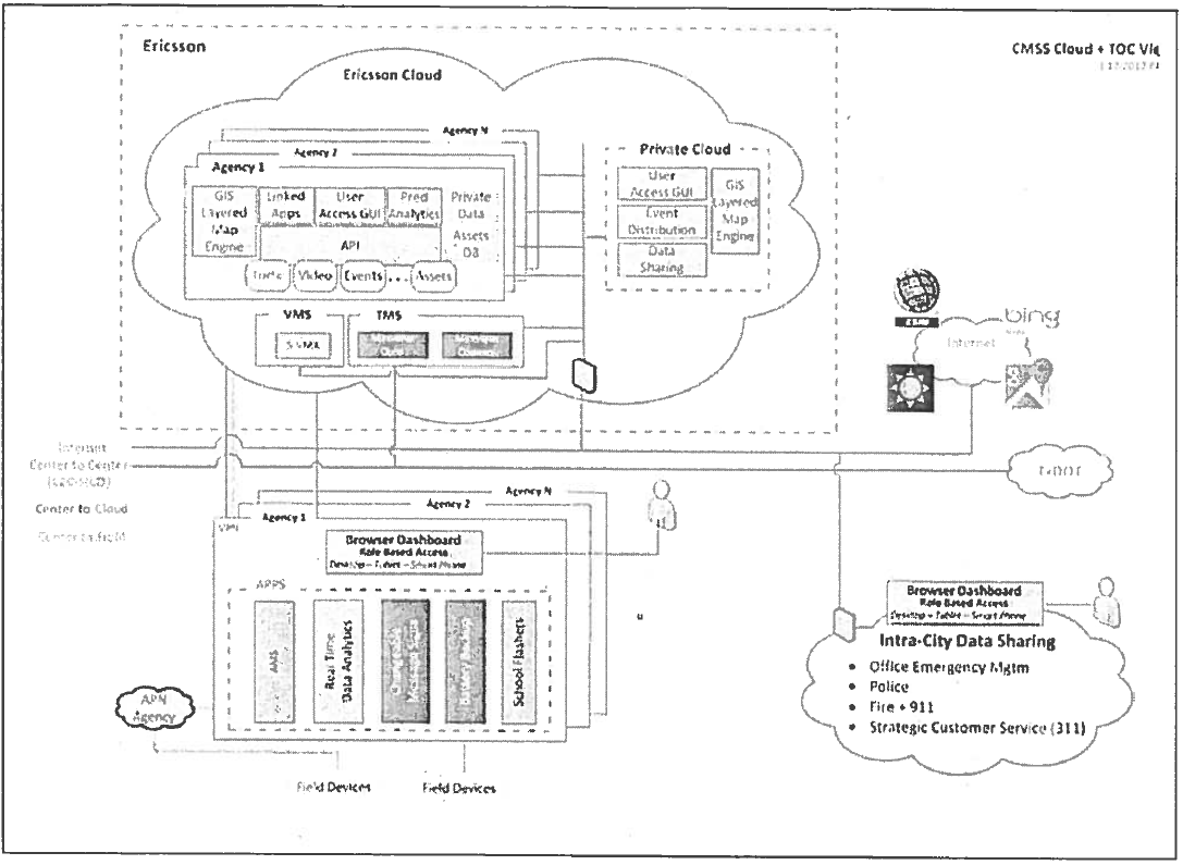
The conceptual architecture for the NCTRSTS is shown in the figure below. Although the modularity of the NCTRSTS virtually allows the agencies to maintain relevant, state-of-the-art applications for a much longer period, the proposed project includes, deployment, operation supports, and lifecycle management over a 10 year period. To reiterate, the initial deployment of the NCTRSTS will include a core group of three agencies; Dallas, Richardson, and Irving.
These three agencies are responsible for operation and maintenance of approximately 33% of the signalization intersections in the NCTCOG region and share operational responsibilities for significant regional arterials. These cities will take full advantages of the NCTRSTS which includes the following, just to name a few:
- Cloud based applications
- Common Graphical User Interface
- Data storage and backups in the cloud
- Sharing of real-time data and video
- Viewing of SPaT and status data of adjacent agency traffic signals.
- Ability to temporarily assume control of adjacent agency intersections for operational changes (requires adjacent city approval)
- Collection and storage of high resolution data for analysis ad research
- Coordination of regional operational strategies
In addition to the Core agencies, the initial deployment will include up to 12 additional agencies that will provide SPaT data to the NCTRSTS Cloud environment. This ''Thin Stream" of data will allow auto makers and OEMs to collect SPaT data for approximately 75% of the signalized intersections in the NCTCOG region through a single cloud portal rather than from individual cities.
7) Regulatory, Legislative, or Institutional Challenges and Obstacles to Deployment
There are no significant challenges anticipated in these environments. The project .is ready for deployment. The only anticipated obstacles lie in the issues listed in Section 4, which are being pro-actively addressed in the areas of security and inter-agency operational governance.
The project has been discussed with several entities to garner expertise and recommendations, including collaborative municipalities, NCTCOG, DART, and the Texas Department of Transportation. NCTRSTS was designed with regional benefits in mind.
8) Quantifiable System Performances Improvements
A recent report commissioned by the U.S. Department of Treasury, "40 Proposed U.S. Transportation and Water Infrastructure Projects of Major Economic Significance," underscored the benefits associated with investing in traffic signal operations improvements. That report found (beginning at pg. A-18) the following:
- Coordination of traffic signals "provides a broad array of benefits, including reduced traffic congestion, reduced emissions . . . and reduced energy consumption."
- "Improving traffic signal operations can have a large impact on transportation system efficiency."
- "Delays at traffic signals contribute an estimated 5%-10% of all traffic delay, or 295 million vehicle hours on major highways alone."
- "Delay saving, even when just considering major arterials, is significant."
- Traffic signal optimization delivery allows "improvements for freight and transit operations."
- "While costs are low for individual traffic signals, real gains depend on corridor improvements."
The study estimated a benefit/cost ratio of over 10x from coordination of traffic signals (pg. A- 19). The benefit/cost ratio was at the highest level found in the study's analysis of 40 major transportation infrastructure projects (pg. 4). This conclusion is similar to that reached independently by others that traffic signal system improvements can deliver substantial mobility benefits for highway and transit users cost effectively.
- Reducing traffic-related crashes, congestion, and costs - The new system will provide the tools the agencies, both individually and regionally, to quantify system performance improvements through the analysis of high resolution data. In addition, research that will be conducted by the Texas A&M Transportation Institute may provide a correlation between the high resolution data and air quality models (see research description below). The tools provided as part of the system will also allow the agencies to prioritize required actions to improve system performance.
- Optimizing system efficiency - With limited funding available for improving system efficiency through the optimization of traffic signals, the NCTRSTS will provide the data and tools to allow the region to prioritize where these limited funds will provide the most benefit for improving system efficiency. Data will now be available to prioritize regional arterial needs. Before and after analysis of the high resolution data will verify the system performance improvements of signal re-timing in the region. The transportation system efficiency will also be improved when drivers have access to real time data through connected vehicle technologies. The proposed system intends to greatly expand the delivery of SPaT data to auto makers and OEMs to cover up to 75 percent of the signalized intersections in the region.
- Improving access to transportation services - By default, improved transportation efficiency improves access to transportation services for all. The NCTRSTS will allow agencies to identify and target regional arterials for specific improvements to further improve access to employment, educational, and/or recreational centers. Access to transit services will also be improved by virtue of the improved arterial efficiency along bus and light rail routes.
9) Quantifiable Safety, Mobility, and Environmental Benefit Projections
There are numerous studies available that identify the mobility improvements resulting from improved arterial efficiency. Optimized signal timing alone is documented to show a return on investment of 20: 1. With the research analytics proposed for the project, it is highly anticipated that new correlations between regional arterial operations and air quality, mobility, and safety will be defined.
The benefits of improving the highway system via the sharing and use of traffic signal data extend to all travelers and all socioeconomic sectors. The marginal utility of even small improvements in traffic operations is higher, however, with people of limited means. Fuel savings, fewer crashes, smoother traffic flows, improved bus transit operation and greater travel time reliability are things that make a big difference to such people. Those improvements save them money, reduce the likelihood that they will have to face bankruptcy because of health care or vehicle replacement costs from a crash, and allow them to access much needed jobs, healthcare and opportunities more effectively.
The DFW region has many people facing severe socio-economic challenges. Dallas, for example, has the highest number of people living 185% below the poverty line of any American city, and the second highest number of people living 100% below poverty. Over half of Dallas households make less than $50,000 per year, and 28.6% make less than $25,000. Fewer than 20% of jobs are accessible by transit in less than 90 minutes (D Magazine, Dec.5, 2016). On the other hand, Fort Worth has 16.3% of its population living in poverty, which is higher than the national average of 14/1% (ACS 2015). The time and expense associated with transportation puts a major strain on the budgets of these families.
Dallas submits that incremental region-wide improvements in the operation of signalized streets and highways will do more to help disadvantaged populations in the region than a project focused in a single area or corridor. This is especially so since the incremental improvements in the Dallas traffic signal data sharing plan can be delivered using existing tools rather than requiring investments in new field equipment.
10) Vision, Goals, and Objectives
The City of Dallas and its partner agencies envision that the initial deployment of the NCTRSTS will form the foundation of an every expanding regional system that includes not only arterials, but will grow to include freeways, transit systems, as well as other modes of transportation. The new system is easily adaptable to other applications with its open API architecture and cloud based data delivery system. It is anticipated that additional cities will join and participate in the regional management component of NCTSTS through the regional governance committee.
11) Plan for Partnering with the Private Sector or Public Agencies
The proposed project provides numerous opportunities of partnering with other public agencies, academic institutions, and private sector agencies. All partnering throughout the project will be with the stated goal of improving mobility and safety in the North Central Texas Region.
The initial deployment plan identifies the initial partners. Each partner agency will have specific roles and responsibilities during the project. The initial core partner cities, Dallas, Irving, and Richardson will be responsible for system operation and implementation of new actions to meet the goals of the project.
Research Partner and Research Plan - TTI has developed a thorough and comprehensive research plan using the data available from the System. In addition to making traffic signal timing data available to motorists via cloud and cellular connections, there are numerous other benefits for archiving high-resolution data from traffic controllers. High-resolution data consist of a log of discrete events such as changes in detector and signal phase states. Using archived high–resolution data, cities can analyze performance of individual and/or a cluster of traffic signals with regards to queue dissipation, stopped delay, split failures, platoon arrivals, detector failures etc. Performance can also be presented for non-vehicle modes such as pedestrians and transit signal priority as well as rail preemption. While there is value in sending current, and in some cases predicted signal timing data to vehicles to let drivers react positively to it, it is paramount that the cities get this information in real-time to ensure traffic signal systems are performing as intended and as programmed.
With that in mind, TTI will analyze and mine the data to demonstrate key value propositions and benefits of archiving high-resolution data in the cloud or any other centralized repository. TTI's scope in this project is as follows:
- Develop a common analytical tool for engineers and traffic signal operators to identify and analyze controller performance issues at individual or clusters of intersections. TTI will develop a web-based analytical tool with ad-hoc queries, charts, and dashboards for operators and city engineers to identify performance issues and recommend modifications to improve controller and intersection performance. For example, cycle by cycle capacity utilization can be determined where volume data is available, proportion of green time detector was occupied, phase terminations, queue length, events relative to downstream events, detector failure etc.
- High-resolution data from controllers can be utilized to estimate more mobility related performance measures such as stopped delay, platoon arrival time, split failures, vehicle progression. These parameters are crucial for refined air quality emissions analysis. TTI will analyze air quality improvements from the potential changes in controller settings on select corridors.
ATSPM Activities in Texas - The U.S. Department of Transportation (U.S. DOT) is promoting automated traffic signal performance measures (ATSPMs) under its Every Day Counts (EDC) program as a means to improve traffic signal performance. ATSPMs consist of high-resolution data-logging capability added to existing traffic signal infrastructure and data analysis techniques. This provides transportation operating agencies with the information needed to proactively identify and adjust operation of their traffic signal systems. Agency staff can then better conduct traffic signal maintenance and operations in support of an agency's safety and mobility goals.
The City of Dallas and the transportation agencies in North Texas will be able to leverage the work currently being conducted by TTI for TxDOT in applying ATSPM applications to the regional arterial street network. The City of Dallas' project will go beyond the TxDOT project to examine metrics that can be used by multiple cities operating arterial streets across jurisdictional boundaries. This project will also examine the benefits of cloud-based data to facilitate monitoring, measurement, and operations of traffic signals in a region.
The North Texas region is also interested in the emission reduction and air quality improvements that may be generated by improved traffic signal timing from ATSPM applications. The City of Dallas' project will look at tools that can integrate the emission reduction and air quality improvement measures that results from improving traffic signal operation. This in tum, will be integrated into the North Central Texas Council of Government's regional transportation planning process.
Project Linkage to Connected Vehicles and SPAaT Data - Connected vehicles offer the potential to transform the way that mobility can be managed in future transportation systems. FHWA targets revolutionary approaches, methodologies, and breakthroughs to greatly improve the efficiency of highway transportation based on the connected vehicle paradigm. Connected vehicle data like Signal Phase and Timing (SPaT) provide the underlying data necessary for the functionality of various traffic signal related safety and mobility applications. These applications would harness the rich data provided by traffic signals and integrate it with mobile systems in a decision support system to dynamically deploy and alter traffic management strategies, in real-time, that optimize flow and promotes safer, greener travel in the network. On the infrastructure side, applications would issue command and control decisions to activate and alter traffic control devices (such as traffic signals system, ramp meters, active traffic management devices, variable speed limits, etc.). On the vehicles side, vehicles would use concepts and applications such as red light running violation applications to improve safety and Eco Arrival and Departure applications to dynamically form and disband strings of vehicles that can maximize fuel efficiency and minimize vehicle emissions. These applications are expected to make travel not only safer, but smarter and greener.
More and more cities and operating agencies are considering implementing connected vehicle technology to improve the quality of life for their citizens in a cost effective manner. The primary architecture of connected vehicle deployments involves expensive deployments of infrastructure like road side units using dedicated short range communication (DSRC) radios, infrastructure to vehicle prototype (IVP) boxes, and SPaT-enabled controllers. This architecture primarily served the need to improve safety using the low latency DSRC communications.
However these radios and IVP boxes are still being developed and by definition the radio communication is short range. However significant mobility benefits can be accrued by using alternative communication means like cellular from a central location. Many signal controller vendors and other parties are developing technologies to facilitate mobility applications using a close loop traffic management center architecture. Some of these architectures send the connected vehicle signal data to the cloud to be available for original equipment manufacturer (OEM). The cities in the Dallas region have a history of using modem technology to improve traffic flow in their cities. Use of the connected vehicle data in a uniform format will enable OEMs to develop mobility applications that can have a significant impact on the people's lives and will prepare the cities for the future of connected and automated vehicles.
Project Linkage to Air Quality - Since 1991, the Dallas-Fort Worth (DFW) region has been in non-attainment for the ozone National Ambient Air Quality Standard (NAAQS). As a result of this designation, transportation conformity is required for projects identified in multimodal transportation plans to proceed to implementation. To comply with the transportation conformity requirements, state and local transportation agencies use various transportation emission reduction strategies designed to reduce air pollutant emissions in non attainment and maintenance areas by improving traffic flow and/or reducing vehicle use. Congestion Mitigation and Air Quality Improvement Program (CMAQ) is an important source of funding for these projects.
Under the Moving Ahead for Progress in the 21st Century Act (MAP-21) the state department of transportation (DOT) and metropolitan planning organizations (MPOs) are directed to give priority to performance-based cost-effective projects when applying for CMAQ funding. The Fixing America's Surface Transportation Act (FAST Act) continued the CMAQ program as a funding source to State and local governments for transportation projects.
Emission reduction is one key parameter in determining the cost-effectiveness of a transportation project. Uncertainty in emissions estimates has been identified as one of the major limitations of current cost-effectiveness estimates. Current emission estimation methodologies used for transportation projects are usually aggregate methods that are not highly sophisticated and often do not account for local traffic information. Furthermore, these estimates are developed before · the implementation of the project and no follow-up studies are done to validate the assumptions and results. Lack of this information (i.e. before- and after-implementation studies) has remained a major contributor to the uncertainty with the emission estimation and cost–effectiveness of CMAQ funded projects. Among various transportation emission reduction strategies implemented in DFW non attainment areas, traffic signals improvement projects prevails others by the number. The proposed study will improve the accuracy of the methods and assumptions used for emissions analyses for traffic signals based on high-resolution data. Apart from improving emissions estimation for traffic signals, other crucial outcomes of this project are:
- Improvement in state DOTs, MPOs, and city project selection decision making with the aim of maximizing air quality improvements. Easily identify the worst signalized intersections that need improvement based on emission reduction potential
- Applying high-resolution data for estimating emission benefits from traffic signals in non attainment areas for Transportation conformity. Multi-million dollar funding decisions depend on the accurate modeling for mobile sources and the large source of error comes from incorrect traffic inputs
- Accurate dispersion modeling by incorporating high-resolution traffic signal data can refine the project-level conformity analysis
- Achieve higher accuracy in modeling and obtaining realistic results of exposure assessment
- EPA continually works to improve MOVES model database with more precise activity and emissions data. MOVES model estimates can be improved by updating default databases with local information coupled with other information such as activity and engine characterization data
SPaT Partner and Use of SPaT Data - The North Central Texas Council of Governments (NCTCOG) will manage the development and management of regional SPaT data. As part of their oversight responsibilities, the NCTCOG will form a governance sub-committee made up of members from their permanent ITS Stakeholders Committee. This Sub-committee will be responsible for establishing policies for the use of regional SPaT data.
The proposed grant would fund the establishment of streams of traffic signal phase and timing (SPaT) data from the largest municipalities in the DFW region to the cloud in which Dallas is hosting its new traffic signal system. Those SPaT data streams would be accessible to both participating cities and the developer community. The participating cities would use the SPaT data for multi-jurisdictional traffic signal coordination and incident response. The developer community would use the data for connected vehicle and other transportation-related applications. The key components of the traffic signal data sharing project are as follows:
- Establishment of data feeds. There are existing technologies and applications that allow cities to be able to stream their SPaT data to a data portal hosted in the cloud. These solutions include use of a data-sharing module built into existing traffic signal software platforms (e.g., Trafficware) or the installation of a device akin to a Raspberry Pi that collects the raw SPAT data as it is transmitted from the signal controllers to the traffic management center and transmits that information to the users. Both systems have been tested in multiple municipalities. There are other commercially feasible methods that may emerge during the implementation of this grant.
- Content of the data feeds. The data feeds would consist of SPaT data and the traffic signal timing plans of the participating cities. Due to cost considerations, the data feeds from the participating cities would not contain the high-resolution data that Dallas/Irving/Richardson are streaming to the cloud.
- Hosting. The SPaT data streams would converge in a portal in the Dallas Cloud. In contrast to the robust stream of high-resolution data from Dallas, Irving, Richardson, there would be little (e.g., 24 hours) or no archiving of the "thin" data streams from the participating cities, keeping storage costs down.
- Access. City contributors to the SPaT portal in the Dallas Cloud would get access to the data stream via the GUI that is being built into the Dallas system. They would have view-only rights, which they could use to access traffic signal information from neighboring cities for traffic signal coordination purposes, especially in the event of an emergency. Utilization of the GUI being built into Dallas system will be less costly than building access software from scratch. The developer community will get access to the raw data in the SPaT feeds as is. As we have seen from the Frisco and Arlington examples in the DFW region, the developer community is capable of accessing the data without more data formatting /manipulation.
- Participants. The program would be focused on the 15 DFW jurisdictions that together are responsible for 75% of the traffic signals in the region. It would also include smaller jurisdictions along major corridors, whose participation would add significant value. While participation is voluntary, NCTCOG is in the process of amending its funding policy for traffic signal projects, requiring recipients to agree to share their traffic signal data as a condition of receiving NCTCOG funding. Based on a briefing for the region at the [date] ITS Stakeholder Task Force, extensive conversations and their letters of support, wide participation in this grant program is anticipated. The DFW region has regularly rallied around shared regional initiatives such as the building of DFW Airport. The applicant is confident that regional partners will rally behind this grant, if awarded to this region.
- Data Uses. As discussed above, the SPaT data would be used for multi-jurisdictional traffic signal coordination and incident response. The greatest long-term potential value in the data may be in the transportation applications assembled by the developer community for use in connected vehicles. These applications may include (i) in-vehicle traffic signals applications such as that developed by Audi, (ii) improved travel navigation services that use traffic signal data to optimize vehicle routings, some of special interest to the freight/logistics sector, and (iii) applications that help bicyclists/pedestrians navigate. This is discussed in the next section.
- Accelerating Data Uses. The Texas A&M Texas Transportation Institute (TTI) will be engaged to assist participating cities in establishing their SPaT data feed to the Dallas Cloud and in utilizing the data feeds accessible via the Dallas Cloud for inter-jurisdictional traffic signal coordination and incident response. TTI was extensively involved in the Dallas ICM project and through that involvement and its other research activities is well-positioned to provide that assistance.
12) Plan to Leverage and Optimize Existing Local and Regional Advanced Transportation Technology Investments
The Cities' of Dallas, Richardson, and Irving will be leveraging their recent investment and deployment of Advanced Transportation Controllers (ATC) and center to field communication using cellular communications. The Cities have invested heavily in these technologies and the deployment of the NCTRSTS will provide the means for maximizing their return on investment.
13) A schedule for conducting the technology deployment and for completion of all proposed activities. (Timeline)
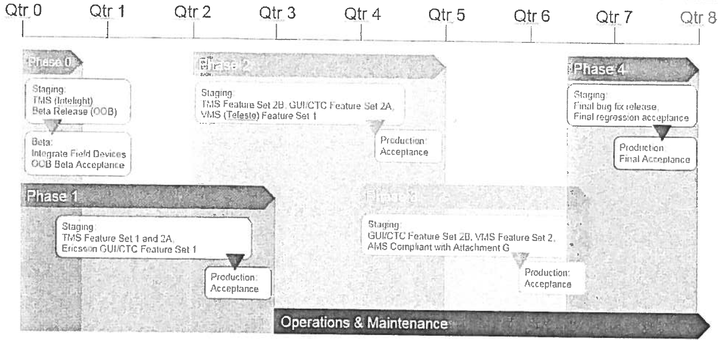
The cloud environment allows for deployment of the system within 24 months from Notice-to-proceed. The deployment plan also includes providing long-term operation and maintenance of the NCTRSTS over the expected ten year project life. A multi-phased deployment provides incremental value for near-immediate return on investment is illustrated in the figure below. Deployment of the NCTRSTS is expected to begin in September 2017.
14) Is There Support or Leveraging of the ITS Program or Innovative Technology Initiatives?
The project will advance the objectives of USDOT's ITS Program. It exemplifies an innovative transportation technology initiative that will transform how people will move.
The ITS JPO's mission is "to facilitate the adoption of information and communication technology to enable society to move safely and efficiently." Its homepage lists "hot topics" and "research areas" that this project will utilize and, more importantly, advance through actual field deployment. These areas include:
- Enterprise data: The project will deliver a scalable enterprise data system that collects traffic signal data from multiple jurisdictions and makes that information accessible to a variety of users via a secure and configurable GUI. The data portal for SPaT data will extend the system to even more jurisdictions. This metropolitan-wide enterprise data system will advance USDOT's enterprise data initiative and provide a model that can be used in other metropolitan areas.
- Interoperability: The project uniquely utilizes private sector resources to help drive interoperable traffic signal data. Based on innovative work done by some municipalities in the region already, Dallas is aware of multiple third parties that take SPaT data as is and scrub it for use by OEMs, travel navigation services and the developer community at large (e.g., Connected Signals, Traffic Technology Services). Instead of using USDOT dollars and taking on substantial additional project risk by trying to get multiple jurisdictions to standardize their SPaT data, the project accepts their data "as is" and makes it accessible to the developer community, which then uses its resources to scrub and standardize that data for use in transportation applications. This is a more effective use of public dollars than trying to impose a one-size-fits-all approach on multiple local jurisdictions, each of which is staffed with committed professionals who believe that their traffic signal hardware and software solutions are the best ones.
- Connected vehicles: DFW is a national leader in the emergence of in-vehicle applications that are powered by traffic signal data. These apps provide drivers with a countdown to when a traffic light turns green and recommended speeds to maximize chances of hitting green Lights along their journey. As with interoperability, the project Leverages private sector interest and expertise in a cost-effective way, namely, the project makes SPaT data accessible for the developer community to build apps rather than use USDOT funds to build a DFW traffic signal app that would lack support from the OEMs and would be more likely to fail than OEM products.
- Automation: The stream of traffic signal data that will power connected vehicle applications for today's drivers will also power travel navigation services for the coming generations of automated vehicles. Such data will help automated vehicles optimize their routes and speeds, making travel more efficient. In this area as well, the proposal utilizes the expertise and resources of the private sector to build these tools rather than use public money to try to match the -fast pace of technology development in the private sector.
- Accelerating deployment: The project has an aggressive but doable timeline that gets the system up and running relatively quickly and starts regional SPaT data sharing relatively soon thereafter. It advances the deployment of connected and automated vehicle applications powered by traffic signal data on a much faster time frame and at lower cost than existing solutions involving the installation of new equipment in both roadway infrastructure and vehicles, something that won't happen for years or even decades.