Arizona Department of Transportation (ADOT) - Loop 101 Mobility Partnership
Project Description
1. Overview of the Loop 101 Mobility Concept and Proposed Technologies
The Phoenix metropolitan area has been experiencing rapid growth in population and geographic area for several decades, as identified in the United States Department of Transportation (USDOT) Report: Beyond Traffic 2045. Maricopa County is home to 4.2 million people and is the fastest growing County in the nation, according to the latest US Census Bureau. This steady growth means an increase in the number of people driving and the number of miles traveled in the region, resulting in congestion challenges on the region's transportation network.
State Route 101L (Loop 101) is a 61-mile loop freeway corridor in the Phoenix metropolitan area and connects residents and tourists to key event centers, educational institutions, and all interstate corridors in the Phoenix metro area. Loop 101 is an important corridor for resident quality of life, access to important services and for tourism and economic development.
|
The Loop 101 corridor is a model deployment candidate for advanced technologies and systems for congestion management and safety.
|
Because of the Loop 101 corridor's importance in the region, the Loop 101 Mobility Partnership was formed to advance this corridor as a model deployment for ICM and connected vehicle (CV) initiatives. The Partnership is formalized with a charter and includes the Arizona Department of Transportation (ADOT); Maricopa County Department of Transportation (MCDOT); Valley Metro (transit and light rail); the cities of Glendale, Mesa, Peoria, Phoenix, Scottsdale, and Tempe; the University of Arizona and Arizona State University.
The Loop 101 Mobility Partnership has jointly developed and agreed to support the following concept and goals, known as the Loop 101 Mobility Project:
- Improve safety and the use of existing arterial capacity in the Loop 101 corridor by deploying technology and systems to support ICM through a decision support system;
- Enhance public transportation service and incident response by using lessons learned from the SMARTDriveSM connected vehicle testbed to deploy intelligent signal priority within the corridor;
- Elevate transportation operations partnerships with public sector agencies and innovative private sector partners;
- Use regional experience combined with advanced technologies to improve traffic management operations for large-scale planned special events; and
- Improve data availability and consistency of traveler information to assist with traveler decision making and influence traveler behavior toward shared mobility.
| ...will address the collective goals of reducing congestion, increasing reliability, and improving incident and event management on the Loop 101 freeway and adjacent arterials. The Project supports regional mobility, accessibility of essential health and educational services, and economic development for the Loop 101 corridor. |
Summary of Proposed Technologies
- A Decision Support System (DSS) - The DSS will collect and use real-time data from agencies and private sector partners, manual inputs such as identified detour routes and signal timing plans, and predictive analytic algorithms to model, assess, and recommend the best set of ICM responses. It will also support performance measurement and evaluation of impacts of the DSS. MCDOT completed a study that identified feasible DSS options, and the Partners will select a preferred option as part of this Loop 101 Mobility Project.
- Adaptive Signal Control Technology (ASCT) for key arterial corridors - Enhanced signal timing technologies will improve cross-jurisdictional signal operations during ICM or other events that generate atypical volumes or flows. ASCT will adjust the signal timing on arterial corridors in response to real-time traffic patterns and congestion.
- Connected Vehicle applications for transit and incident response vehicles - Transit vehicles with routes along Loop 101 or the adjacent arterials, will be outfitted with connected vehicle technology to support transit priority along specific corridors. Improving the movement of transit in the area will help to serve in-need populations (including elderly) and will improve accessibility to destinations and key services. Connected Vehicle technologies will also be used for Regional Emergency Action Coordination Team (REACT) and Arizona Local Emergency Response Team (ALERT) vehicles to improve incident response and responder safety through intelligent priority for responders.
- Adaptive ramp metering technology - This technology will enhance the existing ramp metering system deployed on the Loop 101 to improve throughput and reduce congestion. It will use smart ramp metering technology and detection data from the mainline and ramps to adjust and coordinate the ramp metering rate based on real-time conditions.
- Integrated Traveler Mobility Application – This ICM mobile application suite will improve data exchange between the transportation network and the travelers that are interacting with it. The app will facilitate improved data and information exchanges between the app users and the overall ICM application and DSS in real-time and will include optimum route and travel time information based on the DSS recommendations. It will provide a functionality to improve crosswalk safety for pedestrians and support people with disabilities. It will also improve transit information for passengers and support collection of real-time information from transit passengers. This app will be designed to integrate with the Regional Archived Data System (RADS), an existing open data sharing mechanism, and data will be shared with industry.
|
Benefits to Selecting the Loop 101 Mobility Project With a foundation in the successful AZTech Partnership, the Phoenix metro region has made the technology investments and has demonstrated that we are good stewards of federal transportation funds. It has the foundational elements in place to support implementation of DSS capabilities for recurring and non-recurring congestion management is ready for the next step in system operations and management. These elements include:
|
2. Entering into an Agreement with FHWA
The Arizona Department of Transportation (ADOT) will enter into the agreement with the FHWA for this project. The project will be jointly managed by ADOT and MCDOT. This partnership has proven to be effective for administering and managing past projects, including the 1996 Model Deployment Initiative that resulted in the AZTech Regional Intelligent Transportation Systems partnership. Loop 101 Mobility Partners are members of AZTech and the Maricopa Association of Governments (MAG) ITS Committee, and work with MCDOT and ADOT to collaborate on a variety of programs and systems to support operations and management of the region's transportation network. Additional information about specific partners and their roles in the project is included in Section 14.
3. Geographic Area for the Loop 101 Project
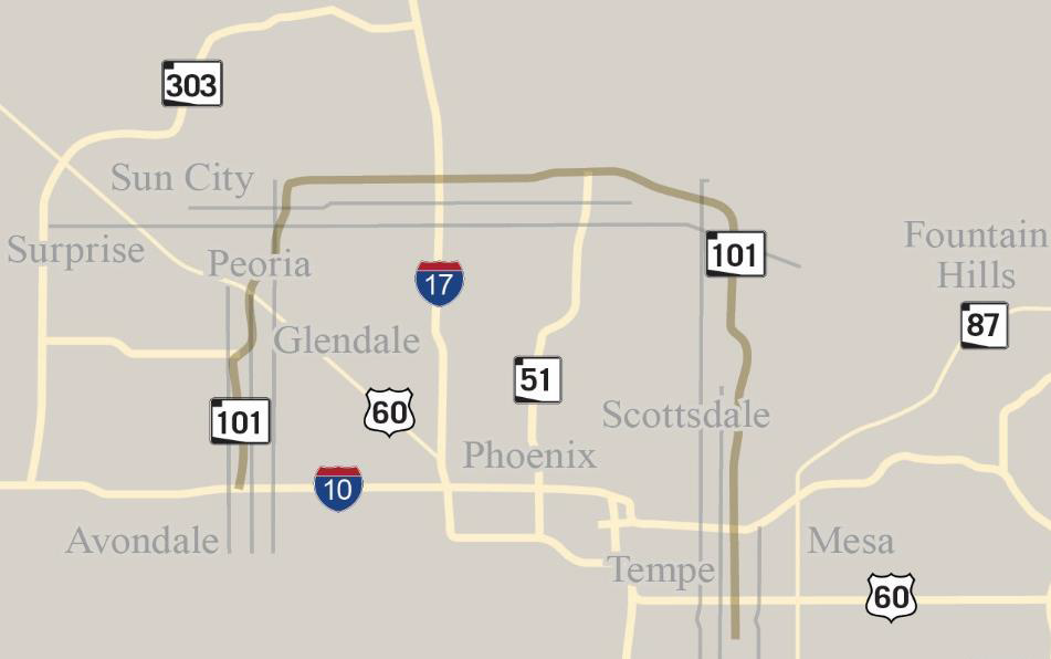
Loop 101 is a 61-mile urban beltway around the Phoenix metropolitan area that connects major cities, freeways and destinations in the region. Loop 101 traverses several cities and communities, including Phoenix, Scottsdale, Tempe, Mesa, Glendale, and Peoria, as well as portions of the Salt River Pima Maricopa Indian Community (SRPMIC) and Maricopa County. Loop 101 also connects to all major freeways in the Phoenix area, including the Interstates 10 and 17, US 60, State Route (SR) 202L (Loop 202), and SR 51.
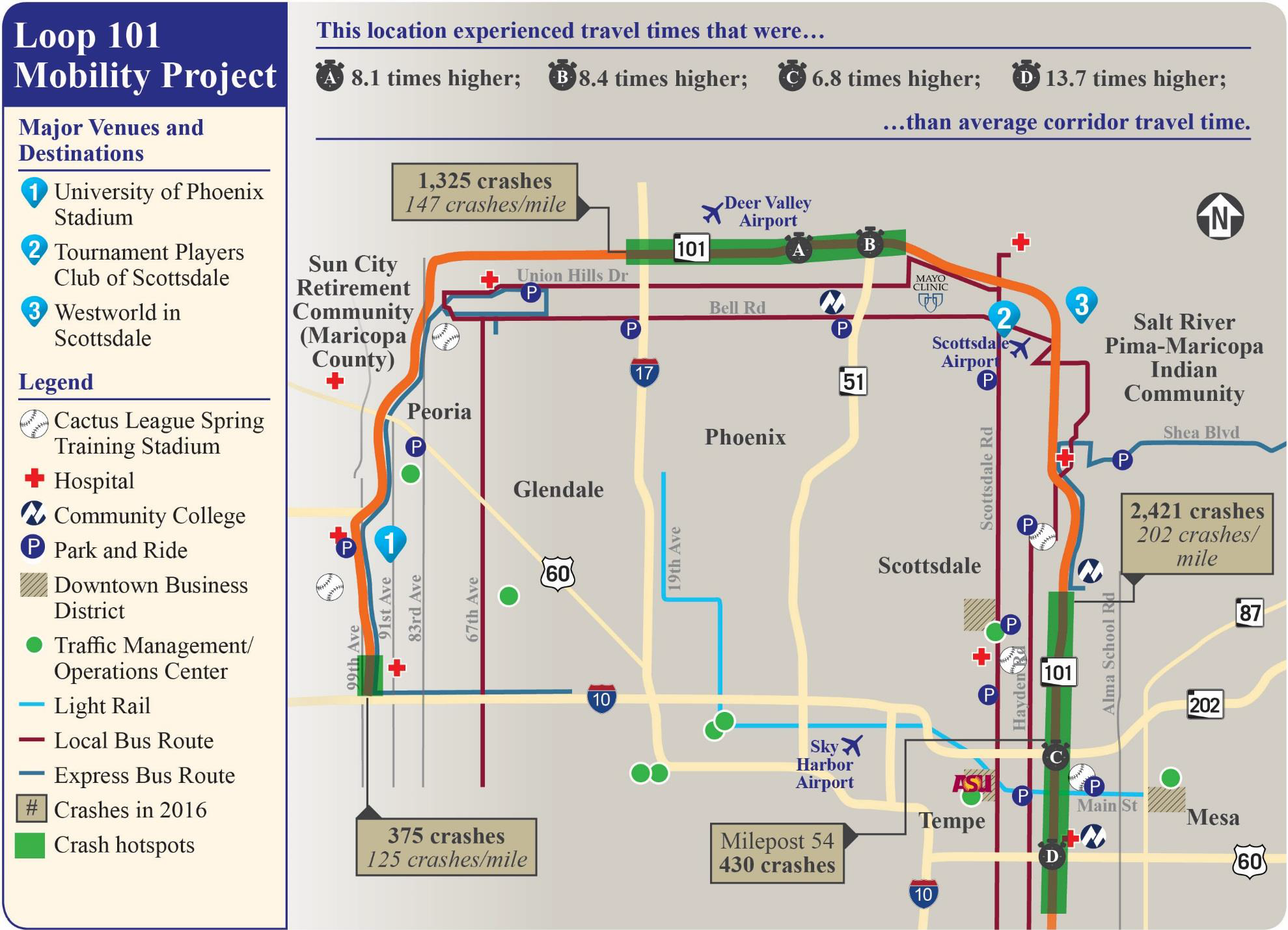
The Loop 101 corridor, shown in the figure on Page 6, provides access to several dynamic downtown business districts, educational institutions (including Arizona State University and multiple community colleges), and several state-of-the-art medical facilities and hospitals, including the Mayo Clinic. There are a variety of residential communities along the corridor, including those with a large aging population towards the western portion of the corridor, each which require different amenities related to shopping, recreation and community gathering.
Finally, the corridor provides access to major event venues that are critical to the state's and region's economic development and tourism, including:
- University of Phoenix Stadium – This stadium is the home of the Arizona Cardinals National Football League team, hosts the annual Fiesta Bowl, has hosted the 2008 and 2015 Super Bowls, the 2016 College Football National Championships, and most recently the 2017 NCAA Final Four Championship Games. This year's Final Four was the second highest attended game in the event's history, with 76,168 in attendance at the championship game and more than 153,000 in total attendance at the two semifinals games.
- WestWorld of Scottsdale – This convention facility hosts annual national events such as the Barrett Jackson Collector Car Auction, which saw a record 320,000 people attend the weeklong event in 2017 - a 20% increase from 2015.
- Tournament Players Club (TPC) Scottsdale Golf Course – The annual Waste Management Phoenix Open Golf Tournament is consistently the highest attended golf event in the country. Attendance in 2017 was record-breaking; weekly attendance reached 655,434 people with a record single day attendance of 205,000 people.
- Arizona State University (ASU) – ASU is a public research university located on five campuses across the Phoenix metro area. ASU is the largest public university by enrollment in the U.S, with approximately 98,100 students enrolled in the 2016-2017 school year at all campuses. The ASU Tempe Campus is the largest ASU campus with an enrollment of approximately 52,000 students.
- Mayo Clinic and Hospital – The Mayo Clinic in Phoenix is ranked the #1 hospital in Arizona and is nationally ranked in 10 medical specialties. It provides medical care for thousands of people from the U.S. and around the world each year and the Mayo Clinic School of Medicine is ranked #10 by US News & World Report.

- Major League Baseball Spring Training Facilities – In 2017, more than 1.9 million fans attended Spring Training games at one of the 10 stadiums throughout the Valley, bringing in more than $800M in economic benefits. Four of the Spring Training complexes are accessed from Loop 101. Sloan Park in Mesa (Spring Training home of the Chicago Cubs) set a single-game attendance record for the league with a single game attendance of 15,523 people in 2017.


The figure on the next page provides an overview of the Loop 101 Corridor, the public transit network that supports it, and the critical destinations and services that are accessible from it. It also provides some key data points and statistics that highlight some of the freeway corridor's challenges with respect to reliability and safety. Challenges and issues are summarized in Section 4.
4. Real World Issues and Challenges
|
Congestion and Reliability
AZTech produces a biannual Performance Indicators report to track and compare key operations and management performance analytics on the region's transportation network, including Loop 101. The most recent report revealed:
- Total Crashes – increased by 5.7%
- Percent of freeway miles – increased by 5.1%
- Percent of time freeway is congested – increased by 6.2%
- Travel Time Index (TTI), the ratio of travel time in peak conditions to free flow – increased by more than 30% on segments of the Loop 101 freeway
The region also experiences a challenge with balancing capacity between facilities. There is underused arterial and transit capacity that can be used more strategically to support the freeways.
Incident Response
As Loop 101 and other freeways experience increased congestion and incidents, transportation and incident management agencies are challenged to provide timely and coordinated responses to safely and quickly clear incidents. Better processes and systems are needed for traveler information and alerts, response plan coordination among agencies, traffic detours off of and on to the freeway, and restoring the network to full capacity.
Connectivity and Accessibility
Travel along the Loop 101 corridor is done predominantly in personal vehicles. There are local service routes as well as several express busses that use the east and west portions of the corridor during peak commute travel hours, including the Scottsdale Road route that has recently reduced its headway from 20 minutes to 10 minutes. The AZTech Performance Indicators report found that transit schedule adherence in the region had decreased by 2.3% in recent years, and implementing intelligent signal priority can help address this. Limited connectivity of transit options reduces access to services along the Loop 101, including medical facilities and educational institutions, to those who are unable to or choose not to drive.
Special Event Traffic Management
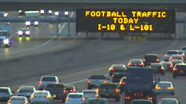
The corridor is challenged by the number of large-scale events that are annually held in the various major event venues. Agencies do collaborate to manage and coordinate the freeway and arterial traffic that is generated by these events, as these events usually create traffic impacts for multiple days (depending on the event) and across jurisdictional borders. Loop 101 Mobility partners recognize that there are additional tools needed to improve system and network operations during these events.
The Loop 101 Mobility Project will address each of these challenges by providing resources and processes to improve incident response, congestion management, public information availability and transit accessibility for the Loop 101 corridor. They will also collectively address all of the goals of the ATCMTD Initiative, as shown in the following table.
| Goals for the ATCMTD Initiative |
|---|
|
| Challenge to be Addressed | How the Project will Address the Challenge | ATCMTD Goals Addressed |
|---|---|---|
| Increase in congestion and delay Percent of freeway miles congested: 2013: 31.6% 2015: 36.7% |
Implementing ICM with a DSS will respond to congestion on the corridor by using real-time data to recommend response plans that consider freeway, arterial and transit conditions. With support of the DSS, the existing capacity of the freeway and adjacent arterials will be optimized and the most vehicular traffic can be moved efficiently by providing alternate route guidance. The DSS will help to improve the timeliness and consistency of information disseminated to travelers, and, in conjunction with the ICM mobile app suite, travelers will be provided with information that allows them to make informed travel decisions for trips along the corridor. | 1, 2, 3, 5, 7, 9, 10, 11 |
| Increase in crashes Total crashes: 2014: 5,258 2015: 5,771 |
The DSS will support improved incident response and clearance along the Loop 101, which will reduce the impact of incidents on travelers and the likelihood of secondary crashes. The ICM mobile app suite will benefit travelers by improving dissemination of traveler information for crashes, detour routes and travel times. The connected vehicle technology will support intelligent signal priority for REACT and ALERT incident response vehicles to improve incident response time for these responders. | 2, 4, 7, 8, 10 |
| Reduction in transit schedule adherence Adherence: 2013: 95.0% 2015: 92.7% |
Connected vehicle technology for intelligent signal priority for transit vehicles will improve the efficiency and reliability of transit service within the Loop 101 and will be less disruptive to other traffic than traditional transit signal priority. The technology can provide simultaneous intelligent traffic signal priority as part of DSS response, which is especially effective when there might be multiple vehicles requesting priority. | 1, 2, 5, 7, 8, 9, 11 |
| Lack of timely and coordinated response plans | The DSS component of this project will directly address this challenge. The region will have access to system-generated responses that utilize diversion routes, can predict congestion patterns, and will automatically adjust field equipment to respond as needed. | 1, 3, 5, 7, 9, 11 |
| Underutilized arterial capacity | The DSS will help identify and execute arterial detour routes that optimize the use of existing capacity based on real-time data. This will be accompanied by the adaptive signal technology, which will optimize signal timing to allow for the best traffic flow on arterials. The ICM mobile app suite will help inform travelers of detour routes in place and provide comparative travel times between freeway, arterial and transit to support traveler decision making. | 1, 2, 5, 7, 9, 10, 11 |
| Limited real-time performance monitoring | The Loop 101 Mobility Project will expand the level and type of data available improve the regions ability to conduct real-time data analytics and generate performance reports about various mobility, safety and cost measures. Tracking these measures in real-time helps agencies identify performance gaps and implement improvements that will improve immediate corridor performance. An example of this is the adaptive ramp metering technology that will adjust meter timing based on real-time detector data. | 3, 5, 6, 10 |
| Increase in large-scale events hosted near the corridor | The proposed technology components will support improved traffic operations for large-scale events. The DSS will help to optimize freeway-arterial coordination for event ingress and egress. Adaptive signal timing will also support event traffic ingress and egress. The connected vehicle deployment on transit vehicles can benefit event traffic management through incentivizing transit. Finally, the ICM mobile app suite will increase traveler information related to routing and mode choice, which can promote changes in traveler behavior, such as taking transit to the event or changing departure times to avoid event traffic. | 2, 3, 4, 5, 6, 7, 8, 9, 10, |
5. Description of Transportation Systems and Services to be Included
The Loop 101 Mobility Project will improve mobility, safety, and access within the Loop 101 corridor. While the freeway is the backbone, the corridor also includes arterial streets, transit routes, event venues, and other local amenities like businesses, schools, hospitals, and residential neighborhoods. The foundation for the Loop 101 Mobility Project is ICM, which will be supported by a suite of technologies for traffic management, data collection and sharing, and public information dissemination.
Five categories of ICM response measures will be considered: freeway, arterial, traffic incident management, transit, and information dissemination. As ICM response measures are implemented, agency operators will monitor the network performance through the respective DSS user interface. Throughout the congestion management process, the DSS will actively monitor the network performance to determine if the current ICM measures need to be modified.
1. Decision Support System
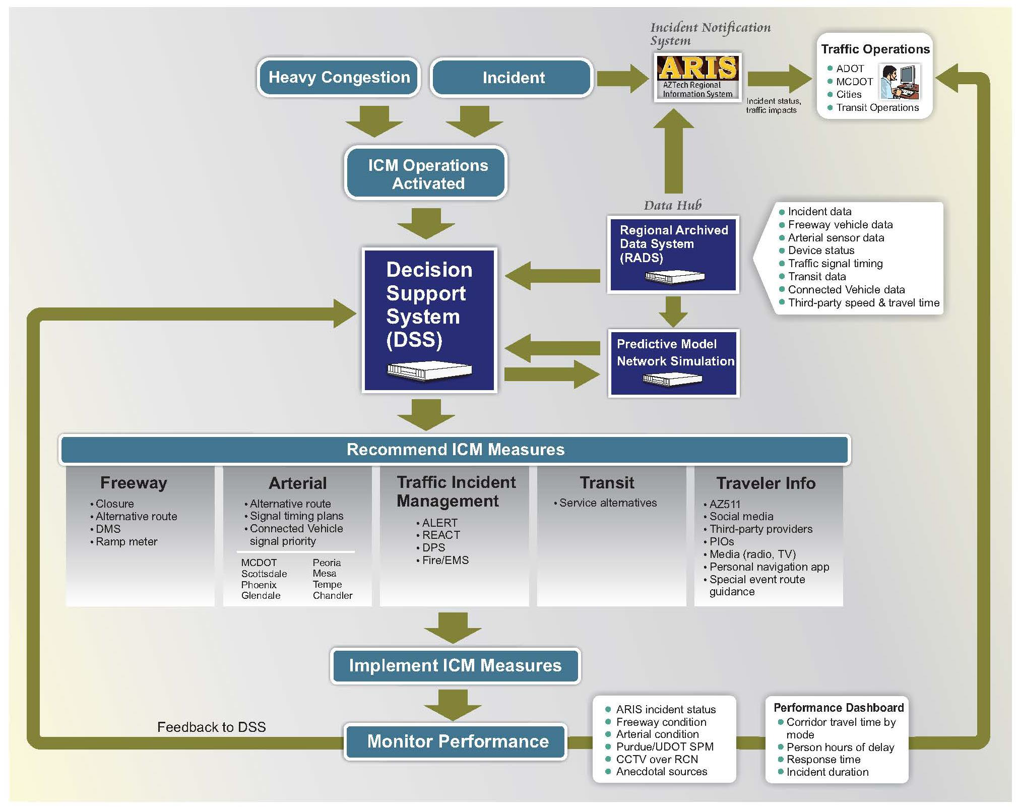
The proposed ICM operation centers on a DSS that contains the traffic operations knowledge base for the Loop 101 corridor. An overview of the proposed ICM systems concept is found on the next page. The DSS is supported by the RADS data hub, which contains up-to-the-minute condition data for the regional network and provides performance measures for the defined corridors. The DSS relies on a network simulation engine that can predict traffic conditions for both recurring and non-recurring congestion using a predictive model fueled by the real-time network data.
Using the real-time data inputs and the predictive model, the DSS recommends specific ICM responses. When a congestion threshold is reached, the DSS will use real-time and preset data (detour routes, signal timing plans, pre-set DMS messages) to assess and recommend the best response plan for the circumstances. When assessing possible plans to respond to specific circumstances, the DSS will perform a multi-objective alternative analysis, and recommend the best response plan based on an overall evaluation of all performance measures of interest. For example, to evaluate a temporary close of an on-ramp in response to an incident on Loop 101, the resulting traffic conditions on both Loop 101 and adjacent arterials will be considered. The DSS can automatically implement the recommended changes, or will notify traffic operations staff at each agency with recommended changes, and an operator can choose to accept or decline the recommended actions for their jurisdiction. In the case of non-recurring congestion (e.g., incidents), the existing AZTech Regional Information System (ARIS) provides timely notifications to the affected traffic operations centers. The ARIS interface also provides continuous updates on traffic impacts throughout the incident duration.
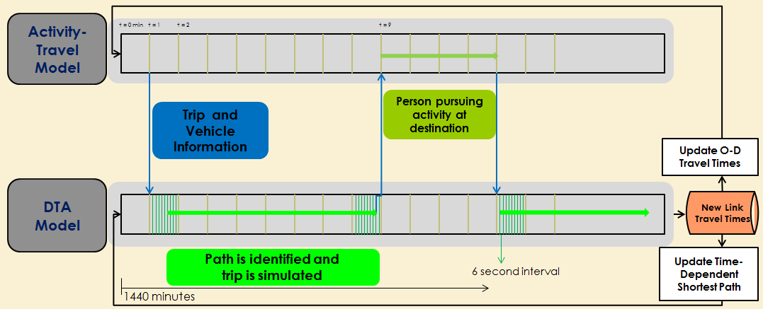
The DSS will be supported by a behavioral model system that reflects adaptation that occurs as travelers gain experience and predictive analytics that provide information about future expected system conditions. A Simulator of Transport, Routes, Activities, Vehicles, Emissions, and Land (SimTRAVEL) framework will be used to dynamically exchange information between an activity-based model and a dynamic traffic assignment (DTA) model to make it possible to reflect the impacts of real-time and predictive information about network conditions on traveler's activity-travel schedules, routes, modes, and destinations.
In the SimTRAVEL framework shown in the figure to the right, the DTA model provides continuous updates on network conditions at regular intervals. These real-time updates, combined with predictive analytics derived from historical data, are continuously made available to travelers with a view to optimize their behavioral mobility choices and bring about system optimal network or corridor operations. More information on the behavioral model and SimTRAVEL can be found as an attachment to this application.
The key to the DSS development is that it facilitates interoperability within the corridor, meaning that the system will be able to support and integrated with all existing local agency systems and data sets and will be able to be expanded within the region to be used by other agencies outside of the Loop 101 corridor in the future. This will be accomplished by following all federal standards and guidance and making sure there is input and agreement by all partner agencies during concept development and system testing.
The DSS will also be developed and operated to provide benefits to the private sector companies who are developing and testing connected and autonomous vehicles within the Loop 101 corridor. The proposed connected vehicle technology in the Loop 101 corridor will benefit equipped vehicles by providing data, such as signal phasing and timing (SPaT) messages, for vehicle applications at intersections. This data will help improve safety and efficiency of vehicles; for example, the SPaT data would enable applications such as providing Red Light Violation Warnings to vehicles prior to entering the intersection to help avoid intersection collision.
An analysis of different types of DSS was completed based on factors that were specific to the Loop 101 corridor. Of the eight DSS approaches evaluated, three were deemed suitable for the region and two were recommended for the Loop 101 corridor – Rule-based DSS and Hybrid Rules/Model based DSS, described in the table on the next page. This project will use a Systems Engineering approach to identify the appropriate and desired DSS structure for the corridor.
| Type of DSS | Suitability for Loop 101 |
|---|---|
| Rules-Based | Suitable – this is a viable option because it addresses the need for flexibility and automation and there are many existing deployments that can be used as models. |
| Hybrid Rules/Model Based | Very Suitable – this option provides the most accurate assessment for DSS, is highly flexible and has a proven performance benefit as documented in San Diego. |
2. Adaptive Traffic Signal Technology for Key Arterials
Enhancements to select arterial signal systems will be deployed to improve cross-jurisdictional signal operations during ICM or other events resulting in atypical traffic volumes or flows. Adaptive Signal Control Technologies (ASCT) will be considered to adjust the signal timing based on real-time traffic patterns and congestion data collected from sensors on the road.
ASCT will support traffic management during major events at the University of Phoenix Stadium or the other event venues located within the Loop 101 corridor. An adaptive signal system deployed on the major arterials around University of Phoenix Stadium (in Glendale) will help manage traffic ingress and egress before and after football games or other large events that are held there. The system will be especially important during times where freeway-arterial detouring from an incident is occurring concurrently with ingress or egress traffic for an event. The adaptive signal control will help address potentially conflicting timing plans that are set for either event ingress/egress or for freeway-arterial detouring.
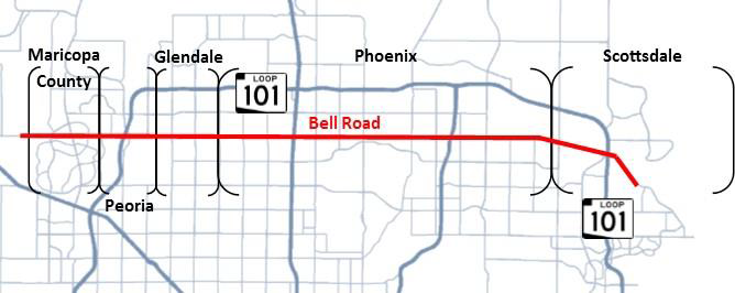
Lessons learned from the concurrent, ongoing project of deploying ASCT on Bell Road, a key arterial corridor within the Loop 101 corridor, will be used to inform the deployment of additional ASCT and make sure that there is consistency between technologies, systems and processes in the various deployments in the region. Nationally, the Bell Road project is the largest multi-agency ASCT project to date.
3. Connected Vehicle Applications for Transit and Incident Response Vehicles
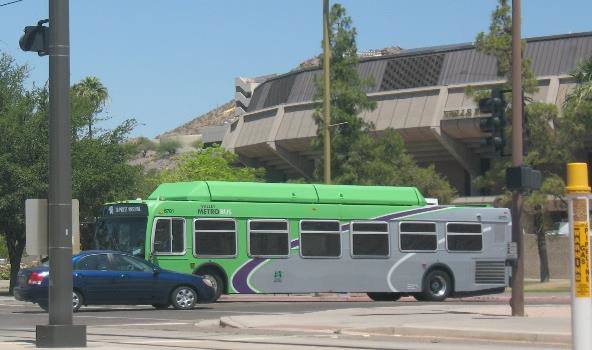
USDOT Multi-modal Intelligent Traffic Signal System (MMITSS) connected vehicle applications will be expanded from the Arizona Connected Vehicle Test Bed in Anthem (Maricopa County) to the Loop 101 corridor to enhance transit service and support incident response and management. Existing transit service in the corridor is critical for supporting universal mobility in the region, so enhancing the ridership experience on transit is critical for regional mobility. Valley Metro transit vehicles, including RAPID express buses and local service buses that support routes along Loop 101 or the adjacent arterials and a select number of vans used for the Valley Metro regional vanpool service will be outfitted with connected vehicle technology to support the movement of transit throughout the region.
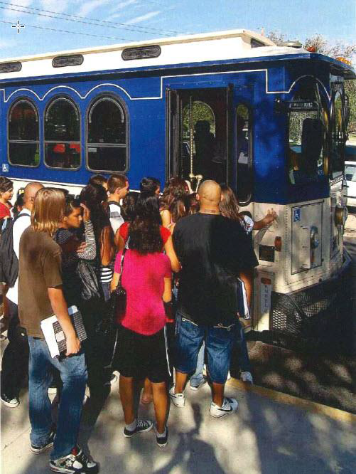
The City of Scottsdale Trolley circulators will also be outfitted to provide CV capabilities, with a focus on the Miller Road trolleys that provide transportation for many grade school students in Scottsdale who do not have other busing options to provide them transportation to school.
The traffic signals along the identified Valley Metro routes and the key Scottsdale Trolley routes within the Loop 101 corridor will be equipped with roadside units to support intelligent signal priority.
For incident management, strategic arterial corridors parallel and adjacent to Loop 101 will be equipped and configured to support connected vehicles. The MCDOT REACT fleet will be outfitted and integrated with connected vehicle applications to facilitate intelligent signal priority during incident response. The technology will also support intelligent routing for emergency vehicles along the Loop 101 corridor. ADOT's ALERT vehicles, which respond to incidents on the freeway and assists with freeway detouring, also will be equipped with connected vehicle technology.
These connected vehicle components will generate Basic Safety Messages (BSM) and infrastructure elements will provide Signal Phasing and Timing (SPaT) messages to equipped vehicles that will be integrated into the DSS. In the future, these SPaT messages can be broadcast to equipped private vehicles.
4. Adaptive Ramp Metering Technology
Ramp meters are already in place along the entirety of Loop 101, and every ramp location currently has ramp demand, passage and queue detection. For this project, ramp meters will be connected with additional vehicle detection located upstream along the ramp and will be interconnected to mainline detection for adaptive ramp metering.
Coordinated adaptive ramp metering will be deployed so that the release rates at one location are coordinated with release rates located upstream and downstream so that control of flow onto the mainline can be optimized on a corridor-wide basis. Ramp meters will be connected to the DSS and the freeway management system (FMS) operating system at the ADOT TOC. A ramp metering algorithm will be integrated into ADOT's TOC central control software and triggered by the DSS as part of a recommended response plan. The ramp metering algorithm will consider ramp queuing, freeway congestion, and potentially arterial backups from ramp queuing to determine metering rates.
This type of coordinated ramp metering is currently being piloted by ADOT on SR 51 in Phoenix, with the goal of expanding its deployment throughout the Valley. The lessons learned and algorithm that results from this pilot will inform the ramp metering deployment for the Loop 101.
5. Integrated Traveler Mobility Application
An ICM mobile app suite will be developed to integrate with the DSS which will provide enhanced traveler information and information exchange with the app users.
There will be three key app functions:
- Users will be provided with alerts that are generated by the DSS related to response plans on the Loop 101 corridor that may impact them. For example, a user may get an alert about crashes or detours that occur along the corridor, with the alert including the optimum route and travel time for that driver based on the DSS recommendations;
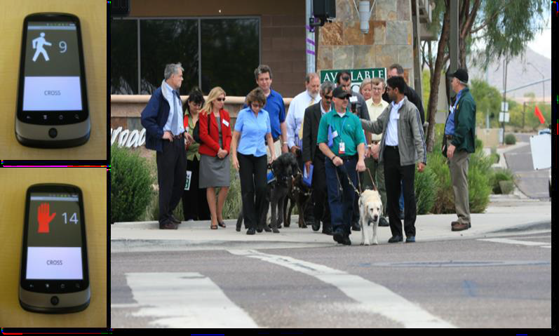
- Users with physical disabilities can use the app to help them safely cross the street at a crosswalk by triggering extended pedestrian crossing time (shown in the photo below); and
- Users will be able to use the app for real-time transit information including schedule adherence, location of connection points between routes and vehicle occupancy. It will also allow users to provide real-time about the transit system, such as the number of passengers waiting for a specific bus, that will feed the DSS.
All software developed for the ICM mobile app suite will be made available through USDOT Open Source Application Development Portal.
6. Deployment, Operations and Maintenance Plan
The Loop 101 Mobility Partners are committed to applying sound practices for system deployment, operations and maintenance. The Partners recognize that they will need a proactive maintenance strategy to sustain the benefits of the deployed technologies. In this region, each agency is responsible for operating and maintaining the infrastructure within their jurisdiction. For regional systems, such as RADS, the Regional Community Network (RCN), the AZTech Regional Information System (ARIS) and other enabling regional networks and system, ADOT and MCDOT take leadership roles for operating, maintaining, and enhancing these systems. The Partners will apply a similar approach to these technologies.
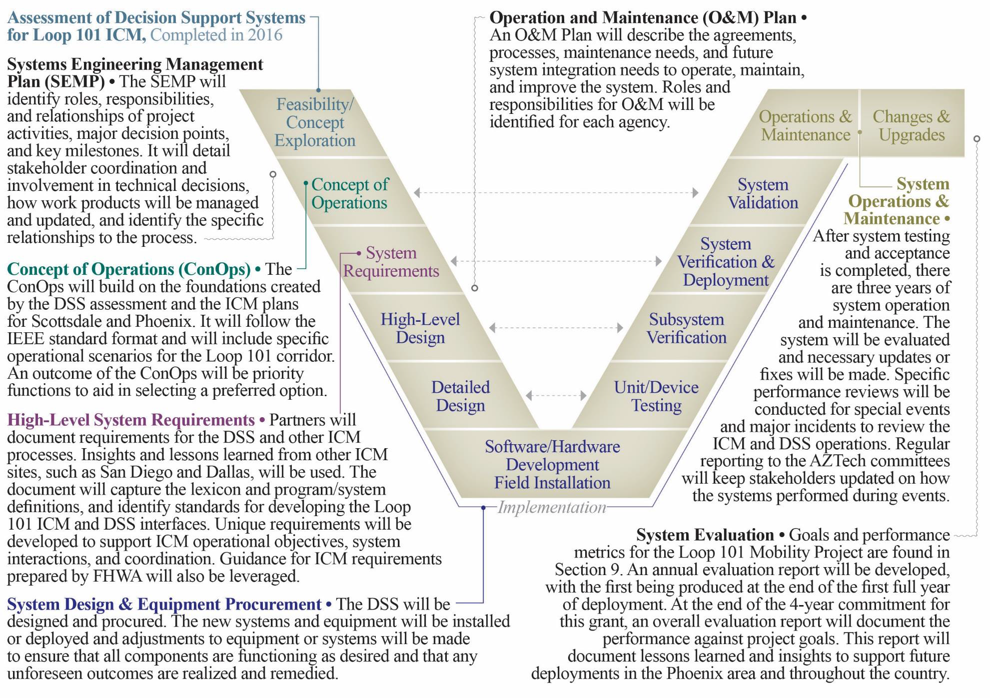
The team will follow a system engineering approach in planning and deploying the proposed project, described in the figure on the next page.
The first deliverable will be a Project Management Plan (PMP), which will be jointly led by ADOT and MCDOT. The PMP will include an overall plan and approach to managing the project components and deliverables. It will also include a Communications Plan, a Risk Management Plan, Schedule, Schedule Management Plan, and other key components.
7. Regulatory, Legislative, or Institutional Challenges
From a legislative perspective, there are no specific limitations to the proposed Loop 101 technology and DSS implementation, and there is no new legislation needed for broader implementation. Arizona's Governor Ducey issued an executive order for testing of Automated Vehicles. All vehicles proposed for this deployment are agency operated. This Executive Order allows agencies to enter into public private partnerships for transportation advancements.
As a result, Arizona is a lead state for automated vehicle testing. Several CV/AV manufacturers including GM, Waymo and Uber are testing vehicles on public roads within the Loop 101 corridor. Collaboration to exchange data between infrastructure and connected and automated vehicles will be desirable for improved safety and mobility.
While there is excellent institutional collaboration and partnerships already established, there are some anticipated challenges in defining operational parameters. The Loop 101 Mobility Partners will collaborate to address the following anticipated challenges:
- Outreach and engagement of local law enforcement and emergency response agencies. There is a good, working relationship among the partner agencies and the Arizona Department of Public Safety (DPS), but there are occasional challenges when trying to engage with local responders such as local police and fire. There is a strong TIM Coalition in the region which includes participation from some of these local services, so we will work with Arizona DPS through the TIM coalition to promote this project and collaborate with the group on operational strategies.
- Defining arterial signal operations strategies. Each arterial agency in the Loop 101 Mobility Partnership operates its own traffic signal system from their respective Traffic Management Centers. There will be efforts to work through operating scenarios, modeling and strategies among the partners for the DSS. There is a good foundation for cooperating, and the partners recognize that this could require some changes to signal operations.
- Building trust with automation. Partner agencies do not have experience with automation for decision making and might be hesitant to accept full automation of systems through the DSS. To improve trust in automation, we will ensure that all agencies are involved in the development and inputs for the DSS. Further, we will look to run several simulations during DSS development and testing which will remove some of the uncertainty behind the process and outputs of the system. Peer to peer workshop with the agency representatives that have deployed the DSS will also foster trust building.
- Outreach to the public to build trust with new services and technologies. A collective effort is needed to develop a public outreach and education campaign. There will not be many visible changes on the roadway as a result of the project, so it will be important for local travelers to be aware of the new services and applications that are available. An important part of this campaign will be to share some of the high value system benefits that are measured, such as reduced crashes or egress times or major events.
8. Quantifiable System Performance Improvements
The goals for the Loop 101 Mobility project are:
Safety Goals
- Reduce traffic incident management response time on Loop 101 corridor by 25%
- Reduce number of secondary crashes on Loop 101 and identified parallel arterials by 30%
Mobility Goals
- Reduce egress time for mega events (50,000+ attendees) by 10%
- Increase transit on-time arrival within the corridor by 5%
Cost Savings Goals
- Cost savings to travelers related to travel time savings of $4 million after first year of deployment
- Annual cost savings of $1 million related to fuel savings
Institutional Goals
- Create a system that is transferable to other corridors within the Phoenix metropolitan area
- Increase public awareness of ICM through dissemination of information on all agencies websites and publications
- Increase public trust in alternate routing and alternate mode information by providing reliable and consistent information
- Formalize public-private partnerships with companies who are innovating and manufacturing connected and autonomous vehicles and equipment to create a mutually beneficial and collaborative environment for next generation technology development.
In addition to these network-side goals, the use of a behavioral activity-based travel model as part of the DSS allows the team to derive demand-side performance measures, which include utility measures for travelers within the model based on different ICM response plan. This creates an opportunity to measure:
- Environmental justice and social equity results of specific response plans based on whether specific market segments are gaining or losing disproportionately;
- The gain or loss of accessibility that results from alternative response plans.
| The project team has expertise in computing measures that quantify the value travelers put on enhanced access to opportunities as a result of congestion management strategies and technologies.
The methods and tools integrated in this project will provide a holistic impact assessment by considering network performance measures, travel utility measures, and opportunity-based accessibility measures. |
9. Quantifiable Benefit Projections
The anticipated quantifiable system improvements that are expected from the deployment of the Loop 101 DSS and associated components are shown in the table below. These benefits were documented in recent evaluations of the ICM deployments in San Diego, and extrapolated for the Phoenix metropolitan area.
| Performance Analytic | Value | Value ($) |
|---|---|---|
| Reduction in Delay from Incidents (Person-Hours) | Reduced by 3-5% per incident | n/a |
| Annual Travel Time Savings (Person-Hours) | 450,000 - 650,000 person hours | $4,095,000 - $10,010,000 |
| Improvement in Travel Time Reliability | Between 6% and 7% | n/a |
| Reduction in Secondary Accidents | Up to 15% | n/a |
| Fuel Saved Annually (Gallons) | 500,000 - 700,000 Gallons | $1,100,000 - $1,540,000 |
| Emissions Saved Annually (Tons) | 5,000 – 6,800 Tons | $175,000 - $238,000 |
10. Vision, Goals, and Objectives
The vision for this project is to:
Support quality of life and economic development in the Phoenix metro area by improving reliability, safety and accessibility of the Loop 101 corridor and its critical destinations and services.
Integrated Corridor Management is a regional priority for agencies in the Phoenix metropolitan area. There is proof of concept for ICM with the Scottsdale Loop 101 ICM strategy, and the success of this strategy has allowed the region to elevate its vision for this project to realize further safety and efficiency benefits. There is considerable focus on improving how agencies can coordinate and manage the transportation system, and ICM approaches are ideal to advance those objectives.
An additional objective is to integrate private sector innovations, including mobile and automated systems.
The Loop 101 Mobility Partnership Charter (included in an Attachment), was signed by all partner agencies and put forth a vision and set of goals for the Project around which the Partnership is organized and governed:
- Improve safety and the use of existing arterial capacity along the Loop 101 corridor by deploying technologies and systems to support ICM through a decision support system;
- Enhance public transportation service and incident response using our lessons learned from the existing SMARTDrive connected vehicle testbed to deploy intelligent signal priority within the corridor;
- Use regional experience in combination with advanced technologies to improve traffic management operations for large-scale planned special events;
- Improve data availability and consistency of traveler information to assist with traveler decision-making and influence traveler behavior toward shared mobility; and
- Elevate operations partnerships with public sector agencies and with innovative private sector partners.
11. Plan for Partnering
The Loop 101 Partners have a long history of successful partnerships through AZTech initiatives, and there are multiple, established Intergovernmental Agreements (IGAs) between partners to provide inter-agency support for operations and incident management.
Both ADOT and MCDOT have reorganized to emphasize TSMO within their organizations. This provides strong leadership for the Loop 101 Corridor Project, and provides an overarching TSMO philosophy and perspective. Executive Leadership for ADOT and MCDOT have signed a letter supporting this project, and it is included as an Attachment to this proposal.
As outlined in the project charter, the following partnering strategies will be deployed to create the foundation for a successful and highly supported project:
- Establishing a technical advisory group who will oversee and provide input on the development and deployment of the Loop 101 Mobility Project components.
- Conducting regular meetings with project management team to review project planning, design and operations progress and make necessary decisions;
- Leveraging existing partnerships, such as AZTech, the MAG ITS Committee, and partnerships for special event planning at University of Phoenix Stadium and other event venues.
- Leveraging recently established Master IGAs for Traffic Management and Operations between MCDOT, Phoenix and ADOT, and supporting development of additional Master IGAs to allow for the general sharing of resources between the agencies for the purposes of improved transportation management and operations;
- Leveraging private sector innovation and partnerships. AZTech has a long history of involving private sector technology developers and implementers, and this commitment will continue as part of this project. Furthermore, Arizona is an early adopter of automated vehicle testing, with Uber, Waymo, General Motors and other companies already testing self-driving cars on Phoenix area roads. Open data will be available for private sector use across multiple platforms. Several private companies have indicated interest in the Loop 101 Mobility Project and provided letters of support for advancing transportation and mobility in the region through public-private partnerships. These are included as an Attachment to this proposal.
MCDOT and ADOT both have established on-call contracts with ITS and technology consultants to be able to quickly get technical support resources in place to support project tasks, including systems engineering and systems integration.
Outreach and Awareness
The Loop 101 Mobility Project will include a substantial effort toward promoting public awareness and understanding of the Loop 101 corridor activities, technologies and anticipated benefits. An outreach and awareness team will be established, led by communications officers at ADOT and MCDOT. This group will coordinate with local agency communications and public information staff to develop an outreach campaign that will provide consistent messages about the project, describe what travelers will see on their day-to-day travels, and how new technologies will be making their commutes and travels easier along the corridor.
The AZTech partnership has a long history of coordinating with local news media (including TV and radio) to disseminate traveler information as well as to promote local transportation initiatives. AZTech hosts biannual media and transportation summits, with the focus on improving understanding of each other's capabilities and information needs. The outreach strategy will leverage these established media partnerships.
An effective awareness campaign will include multiple levels and strategies. Locally, our agencies have experience with all facets of public outreach and education including:
- Media relations and media features
- Multiple social media platforms
- Producing videos and animation to describe complex technology applications
- Branding and project identity (including logos, web presence and collateral pieces)
- Narrative and collateral materials
- Interactive outreach opportunities, including public meetings, booths at community events
12. Leverage and Optimize Existing Transportation Technology Investments
In addition to the systems and partnerships, there are a variety of local systems and technologies to support traffic and incident management in the region that will be leveraged as part of this project.
Connected Vehicle Technology
The connected vehicle components of this project will leverage the technology advancements and lessons learned of the Arizona Connected Vehicles Initiative and SMARTDrive program, both part of the Arizona Connected Vehicle Test Bed in Anthem (Maricopa County). SMARTDrive is a partnership between MCDOT, ADOT, FHWA and the University of Arizona that looks to develop and demonstrate advanced ITS applications that integrate vehicles with Systematically Managed ARTerial (SMART) roadway systems in Maricopa County. MCDOT continues to field test applications on Daisy Mountain Drive in Anthem, Arizona which is a 24/7 operational test bed that includes 11 intersections.
ADOT is installing Dedicated Short Range Communications (DSRC) radios on I-17 and will connect to the Test Bed in Anthem. This will be the first DSRC deployment on Phoenix area freeways, and will serve as a proof of concept for Loop 101 deployment.
The Test Bed includes MMITSS technologies and several REACT vehicles are equipped with dedicated short range communications radios to support connected vehicle integration. Overall, the Test bed looks to demonstrate capabilities, evaluate benefits, and provide a model for future SMARTDriveSM applications and some of the applications are already being implemented in Tampa and New York Connected Vehicle Pilot projects.
Traveler Information Technologies
Traveler information capabilities in Maricopa County have evolved from the technology demonstrations in the early days of the AZTech Model Deployment Initiative. Core systems, including the ADOT Highway Conditions Reporting System (HCRS) and RADS serve as the data engines that support 511, az511.gov, social media alerts, and data sharing with public and private partners. HCRS includes statewide closures, restrictions, planned events, incidents and weather sensor data, and combine with the ADOT FMS to provide real-time status for the statewide highway network. RADS interfaces with the Phoenix Fire Computer Aided Dispatch (CAD) and DPS CAD systems to obtain information about arterial incidents in the metropolitan area. These systems both support unique capabilities including:
- The AZTech Regional Information System that automatically disseminates information to agencies to support operations decision making when incidents impact the network. Agency users can define specific areas for which they want to receive alerts about incidents and road conditions.
- MCDOT's Advanced Traveler Information System that established a center-to-center system to automate MCDOT and local agency data into the expanded HCRS. With enhanced information in HCRS, 511, private partner data feeds and social media channels can receive updated freeway and arterial conditions information.
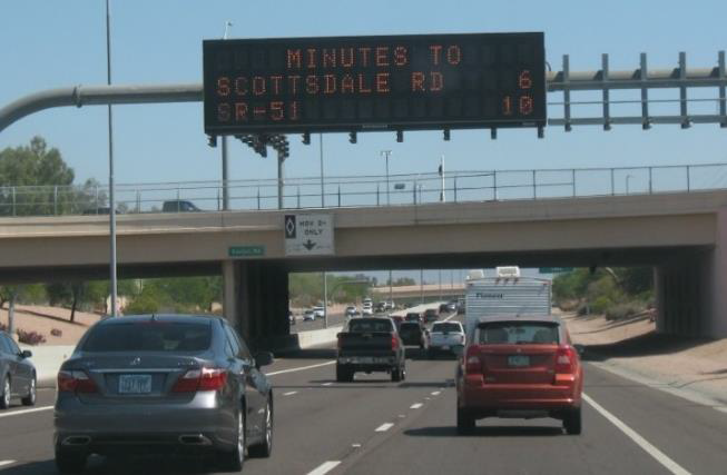
- ADOT has expanded the availability of travel times for the freeway network, providing information on all the freeway dynamic message signs in the Phoenix area seven days per week. There are some locations that provide combined freeway and arterial travel times to destinations.
Data Analytics
RADS will serve as the data hub for the DSS. RADS collects and stores traffic data from agencies across the region such as data from the ADOT FMS, local agencies, third party sources and public safety/emergency response dispatch (CAD) systems. RADS processes travel times for the region's travel time program. The travel time program integrates both freeway and arterial travel times and posts them on freeway and arterial DMS in the region.
RADS receives filtered data from the Phoenix Fire CAD system which provides a centralized database for emergency response generated by 911 calls. This CAD system is the primary real-time source for arterial incidents since Fire is often the first responder when there is a 911 call for a crash. The ADOT TOC and MCDOT TMC have access to the Phoenix Fire CAD system, and the data is integrated into ATIS.
A regional Automated Traffic Signal Performance Measure (ATSPM) system was recently implemented. This is a first regional ATSPM deployment which entails high resolution signal data from multiple agency system. All local and regional agencies within the Loop 101 Mobility Partnership are providing data for ATSPM, which will allow this system to be a key tool for assessing traffic signal performance.
ADOT currently has an active advertisement out for procuring third party data for the State of Arizona, including freeways and arterials. The availability of this data to feed the DSS will directly support the Loop 101 Mobility Project data needs and will dramatically enhance the level of real-time decision making that can be made for the Loop 101 corridor.
Communications Technologies
The Regional Community Network is a high-speed optical fiber-based communication system designed to share video, data, and other information among TMCs. The RCN is the region's communication backbone that supports interagency congestion mitigation activities, links member agencies via a wide area network, and reduces duplicative costs by providing fiber communications for shared use. All agencies are connected to RCN which provides access to shared CCTV camera images, detector data and a variety of other types of data at a regional level and for inclusion into RADS.
Transportation Management Technologies
ADOT operates the FMS throughout the Phoenix metro area, including the Loop 101 corridor. The FMS includes CCTV cameras, vehicle detector stations, dynamic message signs, ramp meters, and supporting communications. As part of this Loop 101 Mobility Project, ADOT will upgrade the existing Loop 101 ramp meters to adaptive technology. ADOT has recently installed adaptive ramp meters on another corridor, and lessons learned will be applied to the Loop 101 corridor.
Local cities and Maricopa County own and operate arterial traffic management devices. Within the Loop 101 corridor there are approximately 330 traffic signals and corresponding detection, dynamic message signs, CCTV cameras, and supporting communications technology. Each local agency also operates a TMC.
Traffic signal timing for key arterials is often coordinated along jurisdictional boundaries through RADS, which allows authorized agencies to share signal timing plans to improve signal coordination. In addition to signal timing coordination, there is a long history of traffic management collaboration for special events, work zones and incidents within the region.
Phoenix and Scottsdale own and operate their own transit vehicles. All other public transportation within the corridor is operated by Valley Metro. Valley Metro provides multimodal transit options including commuter bus service, light rail transit, neighborhood circulators, vanpool service, and demand responsive transit. Currently, the light rail transit system is 26 miles long and serves the cities of Phoenix, Tempe, and Mesa. There are also 26 local bus routes, four express bus routes, a vanpool service and a dial-a-ride service that serve the areas within Loop 101. Valley Metro transit vehicles are equipped with communications technologies to connect them to the central transit management system and automatic vehicle location (AVL) technologies.
Existing Partnerships
There are several sustaining partnerships among agencies in the corridor. ADOT, DPS, MCDOT, Scottsdale and the Salt River Pima Maricopa Indian Community partnered to implement ICM along Loop 101 in Scottsdale. The Scottsdale ICM program is a showcase for ICM knowledge sharing and was included as part of the recent FHWA/National Operations Center of Excellence ICM scan tours. Loop 101 was featured in the report for NCHRP 20-68A, Scan 12-02. This ICM plan includes traffic management protocols between operating and responding agencies to safely detour freeway traffic to preferred alternate routes. The plan includes signal operations strategies, REACT support to guide detouring traffic, and specific strategies for coordination among state and local partners. Following the success of this plan, Phoenix and ADOT identified preferred alternate routes for the northern portion of Loop 101 through the City of Phoenix. Agencies are already taking steps to implement ICM to address congestion and incident management needs.
The AZTech Traffic Incident Management TIM Coalition is a nationally recognized coalition led by DPS and includes ADOT, MCDOT, and a variety of local agencies in the Phoenix Metro area. The TIM Coalition includes participation from Law Enforcement, Fire, Emergency Medical Services, Transportation, Towing/Recovery and others who are critical to inter-agency, multi-disciplinary incident response procedures. The TIM Coalition's goal is to support the response and clearance of traffic incidents as quickly and safely as possible. Members of the TIM Coalition were heavily involved in the Scottsdale Loop 101 ICM planning. The TIM Coalition is actively expanding to include arterial incidents.
An extension of the TIM Coalition is an effort among ADOT, DPS, FHWA and MAG to co-locate a DPS officer at the ADOT TOC to support traffic incident response and coordination. This three-year pilot program launched in January 2015. In the first year of the program there was a 23% increase in the number of freeway crashes, and a reduction in roadway clearance time by 54 minutes (a 63% reduction) and reduction in incident duration by 9 minutes as compared to 2014.
The AZTech and TIM Coalition partners have performed period Capability Maturity Model (CMM) evaluations, with support from the USDOT SHRP Program, to improve operations.
A Special Event Management partnership among the cities of Glendale and Phoenix, ADOT, MCDOT and DPS has established successful processes for managing mega events in the West Valley including the Super Bowl, the College Football National Championship and the NCAA Final Four. This partnership includes:
- ADOT TOC staff operating from the Glendale TMC during major events to improve freeway-arterial coordination;
- Specific routes for the sports teams or other high security travelers to get to the stadium efficiently and safely;
- On-site coordination among ADOT ALERT and DPS for freeway incident clearance;
- Collaboration for video sharing through the RCN.
- On-site coordination among MCDOT REACT, Glendale and ADOT to support traffic management; and
- Corridor-level special event signal timing plans for inter-jurisdictional corridors involving Glendale, ADOT, MCDOT and Phoenix.
13. Schedule
The project will be completed four (4) years after project selection and notice to proceed in October 2017. The proposed schedule is shown on the following page.
The first year will be focused on planning, design, and testing of the DSS and associated components. The remaining three years will be dedicated to evaluating, operating, and maintaining the system. During this time, necessary updates or changes to the DSS or other project components will be made. The project will be completed in October 2021.
14. Support and Leverage the ITS Program and Innovative Technology Initiatives
The Loop 101 Mobility Project is applying lessons learned from the Federal ICM sites, including San Diego and Dallas, as well as other emerging ICM programs locally and throughout the nation. Insights collected will help to inform the DSS and its features and functions, as well as the requirements for supporting infrastructure and systems.
This project also supports and leverages the USDOT Connected Vehicle Technology initiative and the Mobility initiative. Using connected vehicle technology to provide signal priority for transit and emergency vehicles aligns with the multi-modal intelligent traffic safety system. This application will be important for ICM and will support transit schedule adherence and improved incident response time.
The Loop 101 Mobility Partners are following the Smart Cities' developments, including the Columbus Smart City initiative. The Smart Cities approach to data harnessing and data analytics, public-public and public-private partnering, and community engagement and outreach will yield valuable lessons learned that can be applied to this Mobility Project.