3.0 Results from TMC Rapid Response Information Request
Since September 11, 2001, the complexity of incident management in response to new threats has increased the need for coordinated mobilization planning at all levels of government. To support local jurisdictions in their activities to enhance preparedness, the US DOT and the FHWA are encouraging transportation systems to integrate their emergency planning capabilities more closely with parallel processes on-going in their local communities.
Enhanced integration requires a dedicated effort to overcome institutional barriers that have separated transportation from the larger emergency planning community. In spite of an industry-wide initiative to reach out to local communities and improve integration into local planning processes, transportation systems have not yet received wide-spread recognition among emergency management professionals regarding their many potential contributions to community preparedness.
This chapter builds on the results of the 2002 ITS Deployment Tracking Survey by summarizing the results of the information request administered to traffic operations agencies around the country to assess the level of cooperation and coordination which exists between transportation agencies and their local, regional, state and federal partners.
3.1 TMC Organization
To validate the implications of the 2002 ITS Deployment Tracking Survey regarding the institutional relationships which create and sustain TMCs, respondents were asked to identify the partnering agencies that created their traffic operations centers. Almost all respondents (92 percent) reported that the state DOT played a role in creating their traffic operations agencies. State police were the next most commonly cited agency, as 50 percent of respondents identified their partnership role. A range of other partners were also reported, including local DOTs and DPWs, local governments, local law enforcement and Emergency Management Agencies (EMAs), and Metropolitan Planning Organizations (MPOs.) Universities and private technology vendors were the least common partners identified by respondents. Other partner agencies reported to the research team include the FHWA, tollway and turnpike authorities, and traveler/media information centers. See Exhibit 11.
Responding agencies were also asked to characterize their traffic operations agencies as one of the following:
- a single facility responsible for traffic operations within a given region or metropolitan area, that may be co-located with other transportation agencies/functions, public safety personnel, or agencies who do not perform transportation-related activities;
- the hub-and-spoke arrangement, in which a centralized facility is connected to, and shares management of, the transportation system with supporting operations centers; or
- the distributed control model, in which "virtual control" is provided through the shared implementation of a wide-area network. Localized management of signals and other traffic control elements ensures that the wide-area network is used for information and coordination, rather than actual operations.
Please identify the partner organizations that created your regional traffic operations agency. Please check all that apply.
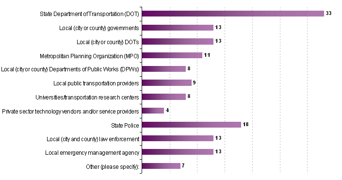
Number of responses - 36
As indicated in Exhibit 12, 61 percent of respondents (22 agencies) have their traffic operations activities located and coordinated within a single facility. Twenty-five percent of respondents (9 agencies) operate in a system with a centralized TMC supported by smaller operations centers in geographically diverse locations, and 14 percent of respondents (5 agencies) use digital and electronic technology to coordinate traffic operations activities among agencies located in different facilities.
Which description most accurately characterizes the organization of your regional traffic operations agency? Please check only one response.
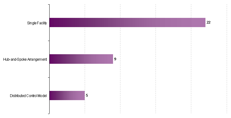
Number of responses - 36
When asked about the agencies that they worked with most closely on a day-to-day basis, 80 percent of respondents identified both the state DOT and the state police. Municipal and county law enforcement agencies were the next most commonly identified (53 and 56 percent respectively). Incident Response Teams, towing companies, local DOTs and local fire officials were also indicated by more than 40 percent of the respondents. The local EOC was the least commonly reported agency. Since many EOCs activate only as an emergency situation is developing, it is not surprising that close day-to-day working relationships with TMCs do not exist. Other agencies identified by respondents include tollways and turnpike authorities and the local media. See Exhibit 13.
In managing day-to-day traffic incidents and operations, which organizations does your agency coordinate with most closely? Please check all that apply.
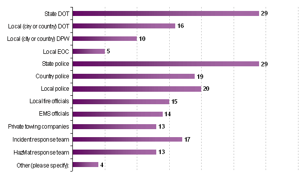
Number of responses - 36
These results reinforce findings from previous research and the 2002 ITS Deployment Tracking Survey, which indicate:
- State DOTs have a critical role in the development and operation of TMCs, and have strong day-to-day interactions with them;
- State law enforcement is the primary public safety partner for most TMCs; and
- The partnership role of local and county law enforcement varies significantly across the TMC universe – some TMCs are co-located with local law enforcement and share operations, while others coordinate with local law enforcement primarily through contacts in state police agencies.
3.2 Threat and Warning Systems
Threat identification and dissemination is an essential element of awareness, prevention and preparedness for both homeland security and natural disasters. While large-scale or otherwise significant events may place transportation infrastructure and national security at risk, even short-term disruptions can have significant, operational, psychological (in terms of public and employee confidence), and economic impact. Devastation resulting from an attack or a natural disaster can extend to other vital sectors of the nation's critical infrastructure as well. Transportation systems are interdependent with other critical infrastructures (especially the communications and information sectors), and the impact of an incident or event during service provision can have cascading effects due to the complexity and resulting multi-sector vulnerability.
To asses the current capabilities of traffic operations agencies to receive threats and warnings related to homeland security and natural disasters, respondents were asked to identify the methods in place for receiving this information. Results are presented in Exhibits 14, 15 and 16.
In Exhibit 14, local media/Cable News Network (CNN) is the most commonly used method through which traffic operations center personnel receive threat information, with 24 agencies (75 percent) citing this resource. Seventeen agencies (47 percent) indicated that they are included on email/phone/fax/pager distribution lists with local emergency management/homeland security agencies and 13 agencies (36 percent) indicated that they are on these lists with local law enforcement. Sixteen agencies (44 percent) participate on email/phone/fax/pager distribution lists with state agencies. Twelve agencies (33 percent) periodically visit the Department of Homeland Security's (DHS) website, while 11 agencies (30 percent) receive alerts from various US DOT modal administrations.
How does your agency currently monitor Homeland Security Advisory System (HSAS) Alert Levels and local/regional/state warning systems? Please check all that apply.
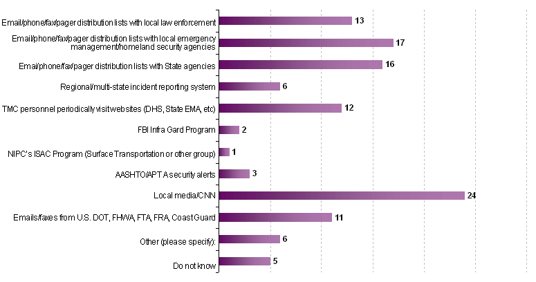
Number of responses - 36
As indicated in Exhibit 15, 28 agencies (78 percent) have access to the Internet to monitor open source information on attacks and events. Twenty agencies (55 percent) receive advisories and recommendations for local and state law enforcement. Less than 30 percent of responding agencies have access to other methods often used to support awareness, such as "Be On The Lookout" (BOLO) or Wanted Persons reports; National Crime Information Center (NCIC) reports; Tactics, Techniques and Procedures (TTPs) briefings; and warnings or analysis from research centers.
Does your agency currently have access to any of the following resources? Please check all that apply.
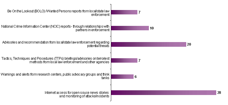
Number of responses - 36
Exhibit 16 depicts how traffic operations centers receive information on weather-related situations which could disrupt the flow of the traffic on the systems within their jurisdiction. The local media/CNN/weather channel provides the most commonly used resource (33 agencies, 92 percent of respondents). Twenty-six agencies receive field reports from transportation personnel and state police which identify road weather conditions and support traffic operations decision-making. Other primary sources of road weather information include National Weather Service (NWS) reports (24 respondents, 67 percent of respondents); deployment of road weather information systems (23 agencies, 64 percent of respondents); and subscription services to weather information providers (17 agencies, 47 percent of respondents).
How does your agency currently monitor warning systems associated with natural disasters? Please check all that apply.
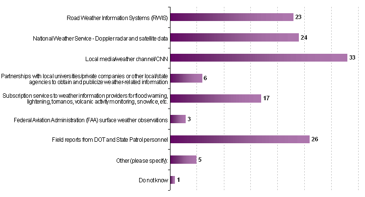
Number of responses - 36
3.3 Notification of Major Incidents and Emergencies
Transportation networks in a regional area may span hundreds of miles and are difficult to monitor. A significant finding of previous research was that traffic operations agencies face institutional and technological challenges in receiving timely incident notification and on-going status reporting regarding events which impact the transportation system.
In response to a series of questions which focused on notification procedures and processes, 22 TMC respondents (61 percent) indicated that they have an agreed-upon protocol through which local or state law enforcement reports the occurrence of emergency events with the potential to significantly disrupt traffic in their jurisdiction. Ten (10) TMC respondents (28 percent) reported that they did not have formally established protocols and four agencies (11 percent) did not know. Two agencies did not respond to the question.
Through these protocols and less formalized procedures, 21 TMC respondents (58 percent) reported that they are notified of an emergency event in less than 5 minutes after its occurrence. Nine (9) TMC respondents (25 percent) are notified between 5 and 10 minutes after occurrence, and four (4) agencies (11 percent) are notified within 15 minutes of occurrence. TMC respondents pointed out that the time for notification varies based on the location of the incident and the time of day during which the incident occurs.
As indicated in Exhibit 17, TMCs receive primary notification of emergency events with the potential to affect the transportation system through telephone calls from state and local law enforcement, radio calls from service patrols and transportation supervisors, and email broadcast messages, facsimiles, and beeper/pagers. Co-located facilities also provide the opportunity for in-person notification from law enforcement and emergency management personnel. Local media is also a significant source of notification. Nine TMCs (25 percent) receive automated notification (via connection to E-911, local EOC, or state or local law enforcement dispatch). This appears to be a growing phenomenon, as four other respondents indicated that they hoped to have this capability in place soon.
In the event of an unexpected emergency in your region (such as a bombing, structural collapse, tornado, multiple fatality accident, technological accident), how are traffic operations personnel typically notified? Please check all that apply.
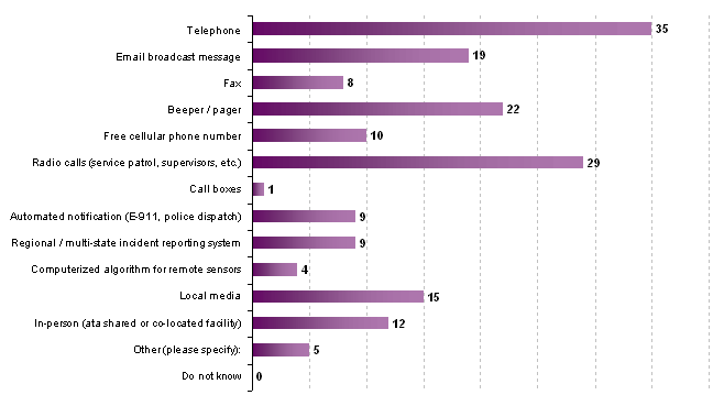
Number of responses - 36
3.3.1 Real-time Electronic Transfer
Eight (8) TMC respondents reported a real-time electronic transfer of incident information from the primary Emergency 911 center to their agency. Information typically received from this connection includes the level of emergency, the location of the emergency, who reported it, event confirmation, and status of response. Twenty-five (25) TMCs reported that do not have this capability and two (2) reported that they do not know.
Twelve (12) TMCs (33 percent) reported a direct connection to the state highway patrol (or local law enforcement) CAD system, which enables them to monitor the police dispatcher's log to determine relevant information such as event location, lanes blocked, event duration, evacuation information, HAZMAT information, suggested detours, and requests for DOT response. Twenty-two (22) TMCs (61 percent) reported that they did not have this capability. However, half of these TMCs do have access to state and/or local law enforcement personnel through shared or co-located space in the traffic operations center.
3.3.2 Additional Information Needed during Notification
When asked what additional information would be useful during notification, responding TMCs indicated the following types of information would best support their activities:
- a complete list of responding agencies;
- estimated time of arrival for responding agencies;
- geographical boundaries of incident;
- a list of incident details and times;
- level of estimated impact on traffic operations (lanes closed, clearance, detours in place);
- surface street conditions at and near the incident;
- concise and consistent categorization regarding incident type, severity, location, and estimated impacts on the transportation system;
- reports of other highway incidents occurring that may related to the major incident (secondary accidents and bottlenecks);
- projected time of incident clearance;
- traffic control methods in place and who is directing the scene;
- estimated duration of incident; and
- aerial overview of affected area.
3.4 Coordinating Field Response
Thirty-one (31) TMCs (86 percent) deploy personnel or contractors directly under their control on-scene in the event of a major emergency. Five TMCs (14 percent) do not have this capability.
Of the 31 TMCs with the capability to deploy on-scene personnel, twenty-three (23) TMCs (64 percent) have trained them in the Incident Command System (ICS) so that they can integrate more effectively with the response initiated by local emergency responders. Twenty (20) TMCs (55 percent) have developed procedures or agreements with local responders to support transportation participation in the on-scene response effort.
Exhibit 18 provides information obtained from the 31 traffic operations respondents with on-scene personnel regarding how these personnel communicate with the TMC during emergency events. Cell phones and digital "walkie talkies" are the most common method of communication (used by 28 agencies, 90 percent of respondents), followed by radio communication (27 agencies, 87 percent of respondents) and beepers/pagers (15 agencies, 48 percent of respondents). Seven agencies (23 percent) use Mobile Data Terminals (MDTs) in vehicles to support communication and coordination.
If your agency deploys personnel on-scene, how do traffic operations personnel at the center communicate with them?
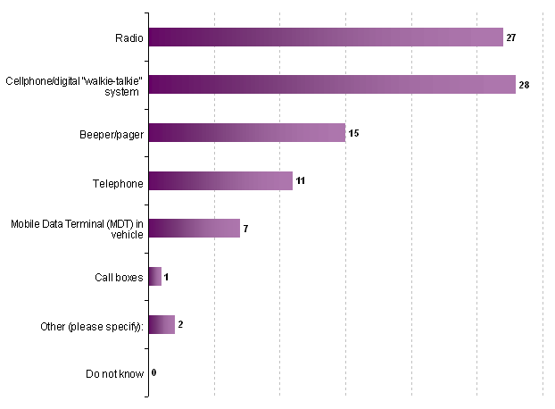
Number of responses - 31
When characterizing the scope of activities performed by on-scene responders under the direct control of the traffic operations agency, respondents identified the following:
- Transportation responders report to the scene and typically use arm bands, vests or badges to identify themselves to other responders. If arriving early on the scene, transportation responders may help to protect the scene by utilizing a truck with emergency lights activated to the rear. Otherwise transportation responders will park at the scene as directed.
- For major incidents and emergencies, the ICS or unified command is established on-scene by law enforcement, fire and rescue agencies, and emergency medical services. Transportation personnel report to a designated briefing area as directed upon arrival.
- On-scene transportation personnel will begin coordinating transportation response activities with the designated Incident Liaison Officer for transportation and by working with the transportation command post. Throughout this process, on-scene transportation personnel will relay information back to the TMC.
- Activities typically performed by transportation personnel on-scene during major emergencies include the following:
- If appropriately trained, transportation responders may provide first aid (as necessary) and coordinate with emergency medical services and fire and rescue personnel to support their operations.
- Transportation personnel may work with DOT maintenance personnel to provide emergency and short-term traffic control setups to protect the incident scene.
- Transportation personnel may also coordinate with law enforcement and DOT maintenance personnel regarding the establishment of alternate routes and assist in their operation as necessary, ensuring that the roadway surface is clear of debris and that construction/work zones are identified and accounted for in all response activity.
- Transportation personnel may also support activities to provide traffic notification near the scene (portable message signs, barriers), and to coordinate traffic systems and devices in the field (signals, lane closures, ramp meters, etc.).
- Transportation personnel may work with DOT maintenance personnel to determine incident clearance needs such as loaders, tandems, brooms or other pertinent equipment and materials and coordinate the use of transportation resources (people, equipment and materials) for recovery of the incident scene.
- Many transportation personnel are trained to help contain and clean up minor hazardous materials spills associated with motor vehicle incidents, and may have ready access to sorbent products that may be used to contain liquids at the scene.
- Transportation personnel may assist maintenance personnel in assessing infrastructure damage; making necessary arrangements for repairs, and reporting and tracking resources requested and used.
- As the emergency incident is stabilized, on-scene traffic personnel will support the opening of lanes and the removal of traffic control devices.
- Transportation personnel will clear the scene when no longer needed.
In performing these functions, on-scene transportation personnel support scene stabilization and safety; provide traffic control and/or immediate detours; support debris removal, assess infrastructure, and begin emergency repairs. On-scene transportation personnel also provide field information back to the TMC and coordinate with the TMC regarding resource requests and tracking.
Several responding agencies identified how important it was in a major incident to have the most senior available supervisor report to the incident scene. Other challenges identified by traffic operations personnel include time-of-day. Service patrols and incident response teams may not be available after hours or on weekends. TMCs respondents also emphasized the importance of day-to-day relationships with state and local law enforcement, local fire officials and emergency medical services personnel. Monthly or bi-monthly Incident Management Task Forces, which meet to discuss general incident management and to review and develop protocols/agreements, were identified as a valuable resource in clarifying roles and responsibilities on-scene.
3.5 Coordinating with Emergency Operations Centers (EOCs)
Twenty-five respondents (70 percent) indicated that their TMC serves as the primary communications and coordination hub for the transportation response. In this capacity, a critical activity is coordinating with local, county and EOCs. These facilities provide a central location where government at any level is able to provide inter-agency coordination; and provide policy level decision making for managing large scale emergencies and recovery efforts. Activation of an EOC enables government to coordinate policy decisions, resource management, and response to disasters and emergencies beyond the scope of an On-Scene Incident Commander.
In the event of a major emergency in their jurisdictions, 28 respondents (78 percent) place a representative at the local (city or county) EOC or state EOC to coordinate strategic activities and response planning for transportation. In supporting EOC activities, traffic operations personnel have varying levels of access to information which could be critical during an emergency:
- Fifteen respondents (42 percent) have supported activity within their jurisdictions to identify existing facilities and road-side locations along major segments of the transportation system that could provide parking and/or staging sites for local responders. Ten of these agencies (28 percent of respondents) have this information in a format that is readily accessible to traffic operations personnel.
- Thirteen responding agencies (36 percent) have access to a listing of temporary shelter sites and reception centers for emergency evacuations.
- Thirty-two agencies (89 percent) can readily identify work zones/construction activity that may affect the performance of roadways/freeways within their jurisdiction under emergency conditions. Fourteen of these agencies (39 percent) have developed an automated tool to manage this information.
- Seventeen agencies (47 percent) maintain a Roadway Characteristics Inventory to support information sharing with local responders and the development of detour/diversion strategies for the transportation system in real-time. Thirteen of these respondents (36 percent) have access to this information in an automated database.
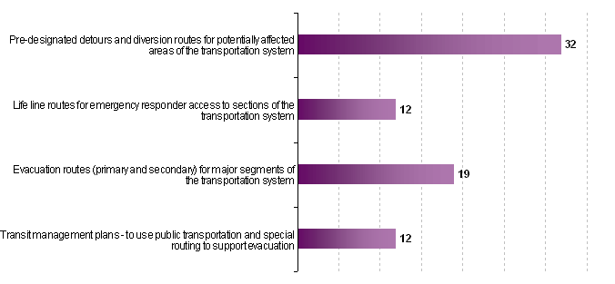
- As indicated in Exhibit 19, 32 agencies (89 percent) have identified pre-designated detours and diversion routes for potentially affected areas of the transportation system; while 19 agencies (53 percent) have identified evacuation routes for their systems. Twelve agencies (33 percent) have coordinated the identification of lifeline routes to ensure emergency responder access to major locations; and 12 agencies (33 percent) have also identified ways in which public transportation can be integrated into evacuation plans.
- Twenty-eight agencies (78 percent) have worked with their local jurisdictions to identify criteria for selecting and recommending detours/diversions and evacuations; while only 15 agencies (42 percent) have developed and tested traffic control strategies for particular alternate routes/detours, contraflow operations and phased evacuations.
In your jurisdiction, has your agency supported or coordinated development of any of the following for rapid implementation during an actual emergency?
Number of responses - 32
Eighteen (18) traffic operations agencies responding to the information request (50 percent) indicate that their agencies have developed protocols with other local and state transportation functions to track activities performed by these partners to manage the emergency event (road closures, alternate routes, signal timing plans, debris removal operations, bus bridges, etc.). Only seven (7) agencies (19 percent of respondents) have developed automated tools to track the status of the transportation response and to monitor the likely impacts on traffic demand and capacity throughout the incident.
Eleven (11) respondents (30 percent) have coordinated with local responders to develop a system for categorizing the severity of an event such that its likely impacts on transportation operations can be assessed early on and communicated to affected transportation organizations (i.e., a Level 1 event will likely result in road closure for no more than 2 hours; a Level 2 event for 2 to 4 hours; a Level 3 event for 4 to 8 hours; and a Level 4 event for more than 8 hours).
3.6 Coordinating with Other Transportation Agencies
To support the sharing of general incident and emergency information among transportation agencies in affected regions and states, twenty-two (22) responding agencies (61 percent) do have an automated tool in place that shares status information with other transportation operations centers that may be affected in neighboring regions or states. Systems in place and used by respondents include the following:
- HCRS (Highway Condition Reporting System)
- California Emergency Services Radio System (CESRS)
- California Highway Information Network (CHIN)
- Data Exchange Network (DEN)
- Southeastern States Email Alert System
- Gary-Chicago-Milwaukee (GCM) Gateway Regional Integration System
- Condition Acquisition and Reporting System (CARS & CARS 511)
- I-95 Corridor Coalition's Information Exchange Network (IEN)
- TRANSCOM Regional Architecture
- The TIMS (Traffic Information Management System)
- TMC center-to-center communications in Texas
3.7 Use of Modeling and Simulation Systems
The responding agencies had limited experience with the use of transportation models and simulations to support the identification and testing of alternate and evacuation routes and traffic control strategies. Of the 36 responding agencies, seven agencies (19 percent) had used CORSIM/TSIS in some capability to support alternate and evacuation route identification; three agencies had used TRANSIMS; and one agency each had used VISSIM and OREMS.
In describing issues/challenges identified by their agencies in using these tools to evaluate alternate routes, evacuation routes, and traffic control strategies during emergencies, the following comments were made:
- In most cases, the modeling process is highly technical and not conducive to group involvement. Limited involvement of operations and maintenance personnel makes it more difficult for them to understand, use and trust the results.
- It is difficult to predict how long it will take to set up a model to run an emergency simulation. Depending on the expertise of the modeler and the quality of available data, estimates in requests for modeling support can be considerably off what was anticipated, with significant implications for budgets and personnel time.
- Information sharing is not always possible in sufficient detail to support modeling. This is particularly true as the transportation network crosses jurisdictional boundaries – if local agencies are not using the same software, then data must be reconfigured and validated. Data files across jurisdictions often have varying levels of detail to support modeling.
- Coordinating and arranging the modeling requires extensive lead-time. Expertise and data requirements are high and so are resource requirements. Given the inherently unpredictable nature of traffic patterns during emergencies, it is difficult to obtain management support for modeling events and strategies which may never occur.
- It is difficult to verify model results under a range of conditions (poor weather, daytime/nighttime). Developments that are forecasted may not happen, and predicted volumes may not occur.
Presently, as reported by the respondents, community emergency response plans and the processes and procedures used support the generation of evacuation routes, detours and diversions, special events planning, and the identification of public shelters and roadside locations to support emergency event staging occur largely outside of the regional transportation organization. This is entirely appropriate, as these are local, regional and state emergency planning functions addressed through a variety of organizations with different jurisdiction responsibilities.
Nevertheless, these plans are based largely on assessments of traffic network information modeled prior to the occurrence of the event. Therefore, these plans, routes and strategies do not reflect real-time, current information on the actual conditions being managed or the resources actually available. Further, regional transportation organizations may not have these routes, resources, and roadside locations integrated into their traffic control systems for easy access and use. Integrating the regional transportation organization more closely into the regional emergency planning process is a major need for improved response capabilities.
In addition, many regions have not yet designated emergency or evacuation routes to be used in the event of an emergency, particularly a terrorist incident. While some regions have identified routes to be used to re-route traffic in the event of an incident such as a vehicle crash that involves a road closure, these route plans are often very localized and do not address the need for a regional evacuation. Many evacuation plans are prepared at a county level and are not coordinated across county lines or state boundaries creating an incomplete and/or inconsistent evacuation route system. Further, there is sometimes a lack of coordination between the DOT and local agencies with jurisdiction over streets to which traffic may be diverted and agreement on the operation of traffic signals and other equipment on those local street systems.