|
|
|
final report
Traffic Congestion and Reliability: Linking Solutions to Problems
4.0 How Can We Deal with Congestion?
4.1 THE TOOLBOX FOR CONGESTION RELIEF
What Can We Do About Traffic Congestion?
The Atlanta experience described above is a good synopsis of potential strategies that can be used against congestion. Transportation engineers and planners have developed a variety of strategies to deal with congestion (Figure 4.1). These fall into three general categories:
Adding More Capacity – Increasing the Number and Size of Highways and Providing More Transit and Freight Rail Service. Adding more lanes to existing highways and building new ones has been the traditional response to congestion. In some metropolitan areas, however, it is becoming increasingly difficult to undertake major highway expansions because of funding constraints, increased right-of-way and construction costs, and opposition from local and national groups. However, it is clear that adding new physical capacity for highways, transit, and railroads is an important strategy for alleviating congestion. In many locations, it is the lack of physical capacity that contributes the most to congestion. In such locations, the addition of new capacity is critical. Further, the addition of new capacity presents an excellent opportunity to combine it with other types of strategies. This often means that highway designers must think "outside the box" and find creative ways to incorporate new designs that accommodate all stakeholders' concerns. Since the worst highway bottlenecks tend to be freeway-to-freeway interchanges, advanced design treatments that spread out turning movements and remove traffic volumes from key merge areas have been developed, often by using multilevel structures that minimize the footprint of the improvement on the surrounding landscape.
Adding new freeways or additional lanes to existing freeways will add large amounts of capacity to the roadway network. However there are other components of the transportation system that can be enhanced that will alleviate congestion, albeit in a more localized area. Widening arterial roads, providing street connectivity, provide grade separations at congested intersections and providing high-occupancy vehicle (HOV) lanes all will help to mitigate congestion. Also, adding capacity to the transit system, whether it is to the bus system, urban rail system or commuter rail system will assist in relieving congestion on the roadway network. Finally, adding capacity to the intercity rail system can reduce the use of highways by trucks.
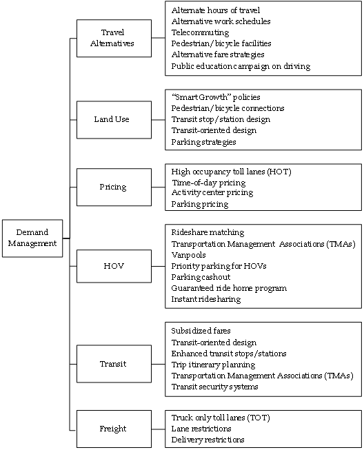
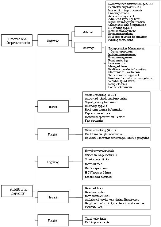
Figure 4.1 A Variety of Strategies, When Used in Combination, Can Effectively Deal with Congestion
![]()
Figure 4.1 A Variety of Strategies, When Used in Combination, Can Effectively Deal with Congestion (continued)
![]()
Operating Existing Capacity More Efficiently – Getting More Out of What We Have. ("Operational Improvements" in Figure 4.1). In recent years, transportation engineers and planners have increasingly embraced strategies that deal with the operation of existing highways, rather than just building new infrastructure. The philosophy behind Transportation System Management and Operations (TSM&O) is to mitigate the effects of roadway events and to manage short-term demand for existing roadway capacity. TSM&O includes the application of advanced technologies using real-time information about highway conditions to implement control strategies. Collectively referred to as Intelligent Transportation Systems (ITS), real-time control of highway operations through a transportation management center (TMC) has become a major activity undertaken by transportation agencies. ITS control strategies take many forms: metering flow onto freeways, dynamically retiming traffic signals, managing traffic incidents, and providing travelers with information about travel conditions, alternative routes, and other modes. ITS is also used to improve transit service and freight activities. In addition to ITS, other TSM&O strategies to improve the efficiency of the existing road system have been implemented, including reversible commuter lanes, movable median barriers to add capacity during peak periods, and restricting turns at key intersections. There are numerous congestion mitigation strategies that are enhanced by the use of advanced technologies or ITS. These strategies are highlighted in italics in Figure 4.1. There are several other effective strategies that do not rely on advanced technology, including geometric improvements to roads and intersections, converting streets to one-way operations and access management.
The idea behind TSM&O strategies is to increase the efficiency of the existing transportation infrastructure. That is, roadway events essentially "steal" roadway capacity and TSM&O seeks to get it back. The deployment of TSM&O strategies and technologies is increasing and evaluations have shown their impact to be highly cost-effective. However, relying on TSM&O alone is a limited approach to addressing the congestion problem. A sound base infrastructure already must exist before TSM&O can be used. Also, only so much extra efficiency can be squeezed out of an already stressed highway system.
Improving the efficiency and reliability of the freeway, street, transit, and freight systems is an aspect of the transportation program that in many cases can be accomplished in shorter time, with more public support and at a lower cost than some other strategy groups. The size of the benefits from any single project may not be of the magnitude of a new freeway lane or rail transit line, but the cost and implementation time also are not as high. One key to understanding the benefits from operational projects is to think of these strategies as enhancing the return on investment in the infrastructure projects.
Encouraging Travel and Land Use Patterns that Use the System in Less Congestion Producing Ways — Travel Demand Management (TDM), Non-Automotive Travel Modes, and Land Use Management. ("Demand Management" in Figure 4.1.) Other approaches to the problem of congestion involve managing the demand for highway travel. These strategies include putting more people into fewer vehicles (through ridesharing or dedicated highway lanes for high-occupancy vehicles), shifting the time of travel (through staggered work hours), and eliminating the need for travel altogether (through telecommuting). The major barrier to the success of TDM strategies is that they require an adjustment in the lifestyles of travelers and the requirements of employers. Flexible scheduling is simply not possible for a large number of American workers, which limits the effectiveness of TDM strategies. Investing in non-automotive modes of travel — such as rail and bus transit systems and bikeways — is another strategy for reducing the number of personal use vehicles on the highway system. These approaches can be an excellent supplement to the highway system, particularly for commuter trips. However, in most metropolitan areas, the level of investment required to meet transportation demand solely through these means is massive and infeasible. Another approach that is being recently considered in many urban areas is managing demand through pricing schemes. Pricing strategies include charging for the use of HOV lanes either by the number of persons in the vehicle or by time of day or both and variable parking charges depending on location, vehicle occupancy, or time of day. Still, when considered as part of an overall program of transportation investments, TDM and non-automotive modes of travel can contribute substantially to a metropolitan area's transportation system.
Land use management is another type of strategy that can influence congestion. The historical cycle of suburban growth has led to an ever increasing demand for travel. Suburban growth was originally fueled by downtown workers who moved from city centers to the urban fringe to take advantage of lower land prices and greater social amenities. In the past 20 years, businesses also have moved to the suburbs to be closer to their employees and to take advantage of lower rents. This in turn allows workers to live even further away from city centers, thereby perpetuating suburban expansion. To influence these processes, strategies that attempt to manage and direct urban growth have been used in several metropolitan areas. These include land use controls (zoning), growth management restrictions (urban growth boundaries and higher development densities), development policies (transit-oriented design, which provides land use densities and forms to favor transit use) and taxation policy (incentives for high-density development). The main problem with many of these strategies is that they often are contrary to market trends, burdening consumers with extra costs and dampening economic efficiency, at least in the short term. Unless a truly regional approach is followed — with cooperation of all jurisdictions within the region — sprawl may simply be pushed into areas not conforming to growth policies.
4.2 USING VISION-ORIENTED PLANNING AND REGIONAL COLLABORATION TO ADDRESS CONGESTION
Perhaps the most important first step to addressing congestion is to have a transportation "vision" for the region that is easily understood, communicated and a part of a consensus-building effort across the region. The traditional transportation planning process, which has been used successfully in metropolitan areas for the past 40+ years, provides a starting place for this activity. Transportation planning begins with establishing a vision, which is then translated into a series of more specific goals. In turn, projects and policies are developed to meet the goals. There may be different goals and solutions for each part of the region, but places that have made progress have had broad support from business, elected officials, and the public for a set of strategies and the funding package to enact them.
Atlanta, Georgia, metropolitan Washington, D.C., and the eight larger cities in Texas are creating vision-oriented long-range plans that add information to the public debate about how transportation investments should be made. In addition to questions like which projects to pursue and what the future growth rate will be, these areas are broadening the financial discussion. These plans are not justifications for additional public spending. They identify a broad range of funding options and the benefits of providing a mix of projects, programs, and policies to improve transportation, along with consideration of the implications for communities and the environment. The goal of these efforts is for the public to understand the choices between funding and the condition of the transportation services. Taxpayers and travelers can decide on the mix of spending and congestion levels that match their expectations.
Incorporating "visioning" into the planning process is nothing new, but what distinguishes these recent efforts is that they are more accelerated, more visible, more inclusive of stakeholders, and focus not just on the long term but on short-term activities that try to achieve "early successes."
In Atlanta's "Aspiration Plan," a key part of this process is the re-examination of near-term improvements and interactions between some plan elements. Some examples include:
- Seeking solutions to bottlenecks in the road and transit networks. These are places where improving a constriction can allow remaining portions of the system to accept more traffic, and can be done over the next few years.
- Is there enough traffic incident management funding and are the responders clearing crashes and vehicle breakdowns as rapidly as possible? Are there good working relationships and defined procedures among the responders? Atlanta has a reputation for extensive operations, but are there other actions that, with some additional attention and funding, could improve the services and system performance?
- Coordinate the traffic signals. This will require local agencies to work together, which will have other benefits. It also is an improvement that is relatively quick to enact and has good public support. It may, however, require a reallocation of operating budgets and may lead to an increase in the Aspirations Plan funding levels, as well.
Atlanta's Aspiration Plan highlights an important aspect of Vision-Oriented Planning — the need to think regionally about solutions to congestion problems. In fact, FHWA is promoting the concept of regional partnerships as a means to implementing effective operations. These partnerships provide a platform for interagency coordination and joint delivery of operations-based services. These partnerships focus on convening a wide variety of stakeholders. They address activities that cross functional and jurisdictional boundaries such as traffic incident management programs, real time traveler information services, response to weather events, and emergency management. Regional partnerships emphasize the importance of linking operations to the existing transportation planning process. Examples include:25
- Baltimore Regional Operations (B-ROC) Project – more than 20 jurisdictions and agencies are participating in B-ROC with the goals of enhancing operational coordination for traffic incident management and to develop a regional framework for operations. Transportation agencies as well as fire and police agencies are all cooperating in B-ROC.
- Cross-Jurisdictional Signal Coordination in Phoenix – was initiated to improve the efficiency of commuting across the Phoenix region. Multiple jurisdictions participated in sharing data and signal control plans that made commuting in long corridors relatively seamless to travelers.
- Capital Wireless Integrated Network (CapWIN) – is an integrated transportation and criminal justice wireless network instituted in the Washington, D.C. region. With CapWIN, agencies will be able to communicate directly with each other and access information for use in planning and implementing traffic control during major incidents.
4.3 THE DIVERSITY IN FUTURE CONGESTION SOLUTIONS
From all that has happened in the past decades regarding congestion, a fundamental principle emerges: No single strategy can adequately address the problems of metropolitan congestion. However, a balanced, comprehensive approach to traffic congestion can lessen the stifling gridlock found on many of our highways. Metropolitan areas are engaged in similar processes of identifying the benefits of additional transportation capacity, operations improvements, changes in demand patterns and land use arrangements, and the costs of achieving those. The outcome of these processes, however, is not similar and it is important to recognize the many reasons for the differences — they go to the heart of local decision-making.
Cities have always had to balance issues of economic development, environmental and social effects, population and employment growth and mobility. What might affect decisions in the future is the evolution in the job market. If the U.S. economy continues a shift away from manufacturing and toward service and information jobs, location may not be as important as it has been in the past. Cities may compete for jobs and population on the basis of quality-of-life issues especially among workers and companies who could locate anywhere.
The decision variations also are present within metropolitan regions:
- More established areas that are not projected for population and employment growth may not have as much need for capacity expansions as developing regions.
- There will always be a role for using what system we have as efficiently as possible. Aggressively managing the transportation system and ensuring that travelers know their travel options are good business practices.
- There are some corridors that will be targeted for treatment because they are important to regional and national freight shipment or person movement.
- Land use pattern changes in redeveloping areas or new growth areas also are part of the solution set. These decisions will vary by jurisdiction.
- All areas will program their funds and efforts toward a variety of goals that include congestion or mobility. But transportation efficiency will not be the only goal and the solutions implemented in each area will reflect that diversity in focus.
With congestion increasing in cities of all sizes and a focus on identifying the best congestion reducing treatments, there is a need for analysis techniques and data to provide some perspective on possible solutions. The move in some large metropolitan areas, such as Atlanta, Washington, D.C., and the large cities in Texas, to craft vision-oriented plans will provide more informed decision-making. Estimating the amount of projects, programs, and policies required to achieve congestion reduction can help focus the public discussions on alternative investment levels and their benefits.
Congestion treatments in the three groups of strategies discussed above have situations that allow their attributes to be cost-effectively used to address congestion problems, quality of life goals and other factors that urban residents, businesses, and travelers desire. The objective of transportation plans and agencies is to identify the right mix of programs, policies, projects, and plans that can be funded by agencies or in partnership with others. Some strategies require planning time, significant funding, and long construction periods, while others can be deployed or enacted in a week. An effective, comprehensive program will include some of the components from each group.
4.4 THE POSITIVE EFFECTS OF OPERATIONAL AND COMBINED STRATEGIES ON CONGESTION
Is Success Possible Against Congestion? Yes, but past success tends to be localized. Multiple and systematic strategies for addressing congestion are required, given that demand is increasing on an already stressed highway system. The following four examples illustrate how success can be achieved by aggressively pursuing a variety of congestion mitigation options.
Results of a Study of the Benefits of Full Operational Deployment
Background
Deployments of operations strategies have been shown to produce significant benefits. Furthermore, these individual operations and ITS improvements can be tied together to achieve even greater benefit than they can alone. Recognizing that the whole is often greater than the sum of its parts, the U.S. DOT and numerous local agencies have launched initiatives to encourage deployment and integration of these systems in order to maximize their potential benefits.26
The U.S. DOT selected Tucson, Cincinnati, and Seattle for case studies representing small, medium, and large metropolitan areas, respectively. Hypothetical scenarios were identified comprised of a wide range of operations and ITS deployments at an appropriate, logical scale for each area. These scenarios were then evaluated to estimate the regionwide benefits and costs.
Although the deployments analyzed did not include the full range of strategies discussed in this report, they did contain a large number of freeway, arterial, traffic incident, and transit management systems and traveler information components. These included ramp metering, integrated traffic incident management, and coordination of traffic signals as well as many other types of strategies. The findings of this study illustrate the potential of operations strategies to help mitigate congestion.27
What Were the Benefits
In all three regions, the analysis of the full operations and ITS deployment showed positive impacts on all performance measures studied, including:
- Decreased travel times;
- Increased vehicle speeds;
- Decreased delay;
- Decreased number and severity of crashes; and
- Decreased environmental impacts (reduced emissions and fuel use).
Table 4.1 shows examples of the impacts estimated in the three regions.
| Tucson | Cincinnati | Seattle | |
|---|---|---|---|
| Delay | -15% | -18% | -15% |
| Travel Time | -2% | -4% | -4% |
| Fatal Crashes | -7% | -9% | -8% |
| Injury and Property Damage Crashes | -3% | -3% | -3% |
| Emissions | -10% to -16% | -18% to -25% | -16% to -21% |
| Fuel Use | -11% | -24% | -19% |
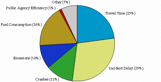
As Table 4.1 shows, the regionwide impacts were significant in all three regions. Further, the positive impacts tended to be greatest during congested peak commute periods, and on major roadways and transit facilities that were the focus of many of the deployments. When dollar values were applied to the estimated impacts, the annual benefits due to the operational deployments were estimated to be $455 million $1,160 million and $1,610 million for Tucson, Cincinnati, and Seattle respectively. These benefits were broad-based as shown in Figure 4.2, which illustrates the proportion of benefits that were estimated for the Tucson region. Similar distribution of benefits also were observed in Cincinnati and Seattle.
Figure 4.2 Proportion of Benefits Value of Full Operations Deployment
in Tucson
When the annual benefits deployments were compared with their costs, the investment in operations strategies was shown to be very efficient, returning $6.30 to $12.20 in benefits for every dollar invested, as shown in Table 4.2.
| Region | Annual Benefit | Annual Costs | Benefit/Cost Ratio |
|---|---|---|---|
| Tucson | $455 | $72 | 6.3 |
| Cincinnati | $1,160 | $98 | 11.8 |
| Seattle | $1,610 | $132 | 12.2 |
A substantial amount of the benefits were due to assuming the deployment of a fully integrated traffic incident management system. By addressing the traffic incident portion of total congestion, total delay to motorists was decreased and travel reliability increased. This demonstrates the point made earlier that by treating roadway events that cause unreliable travel, the double benefit of decreased delay and increased reliability can be achieved.
What Will It Cost?
Many transportation agencies have found it difficult to add system capacity to keep pace with growing congestion. Many times, traditional approaches to congestion mitigation, such as building a new lane or adding a new transit service, are too expensive to be considered as viable options. Operational strategies have been increasingly used to squeeze more efficiency out of the existing system. These strategies can often be implemented at a fraction of the cost of capacity improvements. This is not to say that these strategies do not have significant costs.
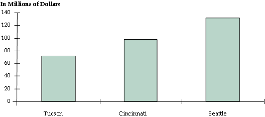
In the case studies of full operational deployments, discussed above, the costs of deploying the operations strategies at the specified level of intensity in Tucson, Cincinnati, and Seattle would cost $78 million, $98 million, and $131 million respectively (Figure 4.3). These costs represent a hypothetical deployment of operations strategies at an intensity greater than currently deployed in these regions, and represent the full cost of implementing the strategies from the ground up. In reality, many of these implementation costs already have been made by the regional transportation system managers.
Figure 4.3 Comparison of Potential Annual Costs in Tucson, Cincinnati, and Seattle
Ramp Metering Strategies in the Twin Cities
In the fall of the year 2000, a unique experiment was conducted in the Minneapolis/St. Paul (MSP) region of Minnesota to answer questions regarding the ability of particular operational strategies to reduce congestion and improve travel safety in the region.28 The findings from this experiment provide a tangible example of success in the campaign against congestion. The MSP region was one of the first in the nation to deploy the strategy, and since that time the system has expanded to be one of the most comprehensive systems in the nation — covering over 430 individual ramps by the year 2000.
Although the DOT maintained a strong belief that the ramp metering strategies provided significant benefits, only an isolated number of evaluations had been performed and the information on the regionwide impacts was very limited. The experiment called for the ramp meters to be turned off for a six-week period in order to evaluate how the system operated without ramp meters, as opposed to conditions when the meters were operating.
What Were the Impacts of Turning Off the Ramp Meters?
- When the ramp meters are operational, they are used to manage the number of cars entering the freeway. This lessens congestion on the freeway and makes it easier for cars entering the freeway to merge into traffic.
- When the meters were turned off, cars were able to enter the freeway during peak congestion hours without being held on the ramps. This eliminated the time previously spent waiting on the ramp signal; however, it also meant that more cars were attempting to enter the freeway at the same time. Bottlenecks were created when people had more difficulty merging into traffic. This slowed traffic on the freeways creating longer freeway travel times. The traffic data showed that the time savings from eliminating the wait on the ramp was more than offset by the longer freeway travel times. This observed impact was consistent with the reported experiences of individuals participating in the surveys.
- When the traffic conditions were compared, it was observed that there were 26 percent fewer crashes on the freeways and ramps when the ramp meters were working. The freeways also were observed to operate at higher speeds with ramp metering. This resulted in more throughput and reduced travel times as a result of ramp metering as shown in Figure 4.4.
Figure 4.4 Observed Benefits of Ramp Meters in the Twin Cities
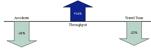
Note: Throughput is the number of vehicles passing over a stretch of freeway in a given time. Usually expressed in vehicles per hour, it indicates that the physical carrying capacity of the freeway has been increased due to using ramp meters.
- Travel times also were observed to be nearly twice as predictable when the ramp meters were operational compared when they were turned off.
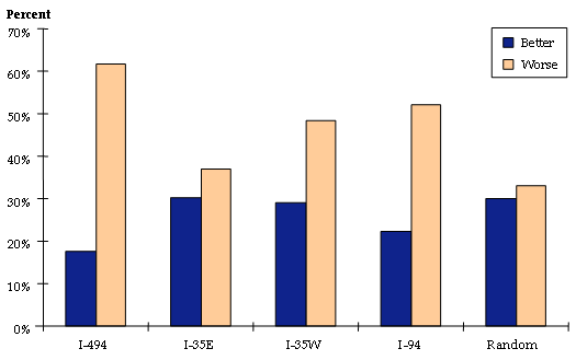
The results from the surveys and focus groups also revealed that most residents felt that the ramp metering system was beneficial to them. Figure 4.5 shows the responses of survey participants who typically traveled on various regional freeway corridors when asked if traffic conditions were better or worse when the ramp meters were turned off. These responses show that more travelers felt that traffic conditions were worse when the meters were turned off than conditions had been when they were operational. The surveys also revealed that approximately 80 percent of the residents supported the use of ramp metering in the region following the experiment.
Figure 4.5 Reported Changes in Traffic Conditions after the Shutdown
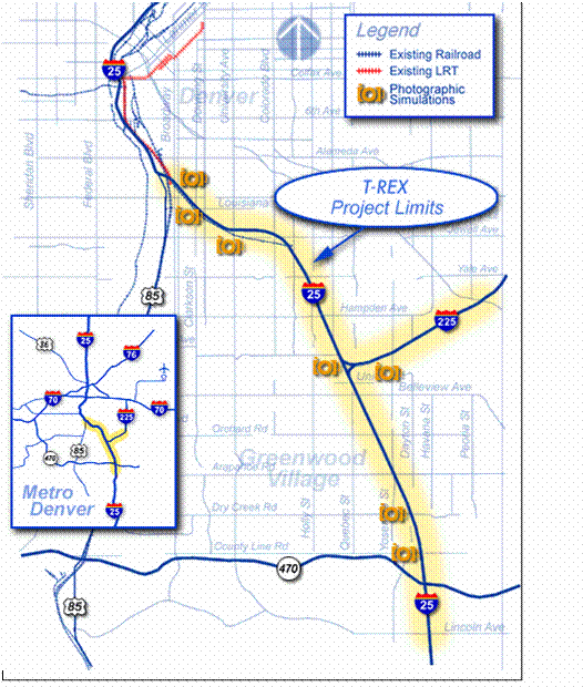
I-25/I-225 Interchange Bottleneck Removal in Denver 29
The Southeast Corridor has long been recognized as one of the Denver region's highest priority travel corridors. The corridor follows I-25, the only north-south freeway in the State, for approximately 14 miles, and I-225, which provides access to I-70, the region's major east-west freeway, for approximately four miles. The Southeast Corridor connects the two largest employment centers in the region: the Denver Central Business District, with approximately 112,000 employees in the mid-1990s, and the Southeast Business District, with approximately 120,000 employees in the mid-1990s. With employment centers at both ends, the Southeast Corridor is the highest volume, most congested corridor in the region. Located approximately in the middle of the corridor is the I-25/I-225 interchange. According to Colorado DOT information, I-25 currently experiences "severe congestion" for several miles on either side of the interchange, and I-225 experiences "moderate congestion." Although several locations in this corridor are potential traffic bottlenecks, the I-25/I-225 interchange is a major one.
Identified as the 14th worst bottleneck in a 1999 study of national bottlenecks, Colorado DOT has since undertaken a massive reconstruction project in the I-25 corridor — nicknamed T-REX (for Transportation Expansion). The project was initiated in 2001 with an anticipated completion date of 2006. The T-REX Project is one of the most extensive multimodal transportation projects in the history of Colorado (Figure 4.6).
T-REX exhibits of the principles being applied to complex bottleneck mitigation projects across the country: a single solution is rarely effective but when multiple strategies are applied, real progress can be made. T-REX is considered by CoDOT to be one their next generation of transportation projects. By combining light rail, highway, bike, pedestrian and other transit options, a multimodal approach is being used to address congestion and safety problems. The T-REX project involves:
Figure 4.6 The T-Rex Project in Denver, Colorado
Transit Strategies
- Adding 19 miles of double-track light rail connecting to the existing system at Broadway in Denver and extending along the west side of I-25 to Lincoln Avenue in Douglas County and in the median of I-225 from I-25 to Parker Road in Aurora;
- Building 13 stations with park-and-rides at 12 of the stations;
- Adding 34 light rail vehicles to RTD's fleet; and
- Constructing a new light rail maintenance facility in Englewood.
Highway Strategies
- Adding one through lane in each direction from Logan Street to I-225 (for a total of four lanes each way);
- Adding two through lanes in each direction from I-225 to the C470/E470 interchange (for a total of five lanes each way);
- Reconstructing eight interchanges, including I-25/I-225;
- Reconstructing and widen numerous bridges;
- Adding and improving shoulders;
- Improving ramps and acceleration/deceleration lanes;
- Design and construct a quality project; and
- Complete the project on or before June 2008.
In 1999, it was estimated that the I-25/I-225 interchange causes 11.3 million hours of annual delay to motorists. When the proposed improvements are completed in 2006, it is estimated that this will be reduced to 2.0 million hours of delay without considering the positive effects of the light rail system (level of service "D" for the interchange). When light rail is factored in, the potential exists to almost entirely reduce delay due to the bottleneck.30
Aggressive Operations
As part of TTI's ongoing analysis of congestion trends, deployments of three operational treatments were studied for the top 75 urban areas (based on population) in 2001: freeway entrance ramp metering, freeway traffic incident management and arterial street signal coordination. These are three important, widely used and easily recognized improvements that reduce travel delay and improve the reliability of travel conditions. The effects of the three treatments also do not overlap, so there is little need to consider double-counting issues. The amount of the system treated, the road section congestion level and the delay reducing effect of the treatment are considered in the estimates.
Table 4.3 identifies the deployment characteristics for the three operations treatments. Signal coordination is the most deployed with all of the cities having some coordination and an average of half of the street system treated. Traffic incident management is deployed in two-thirds of the urban areas and about half of the freeway miles within those areas. Entrance ramp metering is the least often deployed, with one-third of the areas having some treatment and an average of one-quarter of the freeway lane-miles being included in the treated group.
| Delay Reduction | ||||
|---|---|---|---|---|
| Technique | Number of Cities | Percent of System in Cities | Millions of Hours | Percent of Delay |
| Freeways | ||||
| Ramp Metering | 26 | 23% | 73 | 3.1% |
| Incident Management | 53 | 54% | 117 | 5.0% |
| Streets | ||||
| Signal Coordination | 75 | 54% | 16 | 1.4% |
| Total | 206 | |||
Source: Schrank, D. and Lomax, T., 2003 Annual Urban Mobility Report, Texas Transportation Institute.
The effect of integrated traffic incident management is the most significant, reducing freeway travel delay by 5.0 percent. This includes not only deployment of technologies to detect and verify traffic incidents, but more importantly, increased coordination and communication between transportation agencies and emergency responders. Ramp metering deployment has somewhat less effect on overall freeway delay owing to the less extensive implementation. Signal coordination has lower improvement effect for each arterial street, but current levels show a 1.4 percent decline in street delay in the 75 areas studied.
If all the roads were treated with the three strategies, the delay deductions would be as shown in Table 4.4. A total of more than 500 million person-hours of delay are estimated for this option, more than double the current operations treatment amount. This is equivalent to slightly more than three years of congestion growth at the current rate, or just less than 15 percent of total delay.
| Delay Reduction | ||||
|---|---|---|---|---|
| Technique | Number of Cities | Percent of System in Cities | Millions of Hours | Percent of Delay |
| Freeways | ||||
| Ramp Metering | 75 | 100% | 270 | 11% |
| Traffic incident Management | 75 | 100% | 215 | 9% |
| Streets | ||||
| Signal Coordination | 75 | 100% | 34 | 3% |
| Total | 519 | |||
Source: Schrank, D. and Lomax, T., 2003 Annual Urban Mobility Report, Texas Transportation Institute.
Comparison with System Expansion Alternatives
Method 1
The current rate of system expansion in the 75 urban areas is approximately 640 freeway lane-miles and 890 arterial street lane-miles per year. The best estimate we have developed indicates this is about half of what would be needed to stop the growth of congestion. This suggests that 1,530 lane-miles would alleviate an increase of 150 million hours of delay.
If the current deployment percentages are increased from the current levels to 100 percent of both freeways and streets, the role of operational treatments can be compared to the system expansion alternatives. The 300 million hours of delay difference between current and 100 percent deployment rates, if it were allocated over five or 10 years, would suggest an annual rate of decrease between 30 million and 60 million hours of delay. This would be 20 percent to 40 percent of the current congestion growth rate. This might suggest that operational treatment deployments would be responsible for the equivalent of 300 to 600 lane-miles of capacity expansions each year for a total of more than 3,000 lane-miles of freeway and street.
Method 2
Another estimate of the operational treatment deployment benefits can be developed by modeling an expansion of the entire road system in the 75 urban areas. This analysis adds both freeway and street lanes to the road systems, and performs congestion analyses on the resulting expanded system. Table 4.5 illustrates that a two percent increase in road mileage would come close to matching the 300 million hours of delay savings growth between current and 100 percent deployment. This is equivalent to 1,590 freeway lane-miles and 1,630 lane-miles of arterial streets.
| Percent Added Roadways | Total Delay (Millions of Hours) | Delay Reduction (Millions of Hours) |
|---|---|---|
| Base Condition | 3,600 | - |
| +2% | 3,320 | 280 |
| +3% | 3,190 | 410 |
| +4% | 3,070 | 530 |
Note: Greater than 530 million hours of delay reduction would require 3,180 Freeway LM and 3,260 Principal Arterial LM.
Source: Schrank, D. and Lomax, T., 2003 Annual Urban Mobility Report, Texas Transportation Institute.
Three operational treatments, if deployed on all major roads in 75 urban areas would develop a delay savings of more than 500 million hours each year. With current delay estimates in the range of 3.5 billion hours, these savings would be very significant. To achieve a similar delay reduction with system expansion alternatives would require 3,100 freeway lane-miles and 3,200 arterial street lane-miles. The 6,300 lane-mile savings would be a one-time savings and would not add to the total each year. But if the operations programs were expanded from current levels to 100 percent of the system over the next five to 10 years, they would significantly change the congestion growth rate, reducing the projected rate of growth by 20 percent to 40 percent per year.
4.5 SUMMARY
Success against congestion is achievable. Numerous strategies exist in our Toolbox to battle congestion. Previous experience suggests that to be effective, however, two basic principles should be followed:
- Strategies should be targeted at specific problems. Knowing the nature and extent of congestion problems in an area or corridor is the first step toward a solution; and
- Strategies should be used in combination, rather than individually. Because many strategies are complementary, using them together provides synergy. This is particularly true of operations strategies — when used in conjunction with reconstruction, they can provide additional congestion relief by targeting other aspects of congestion besides physical capacity (e.g., incidents). In some cases where bottlenecks are a significant problem, there will be no getting around the need to add new capacity.
25 Federal Highway Administration, Regional Transportation Operations Collaboration and Coordination: A Primer for Working Together to Improve Transportation Safety, Reliability, and Security, http://ntl.bts.gov/lib/jpodocs/repts_te/13686.html.
26 Publication of this research is forthcoming.
27 The ITS Deployment Analysis System (IDAS) model was used to study the effects of fully deploying operation strategies in the three cities by the year 2020. Costs were also derived using the IDAS model. The results are therefore simulated, rather than based on direct measurements.
28 Cambridge Systematics, Inc., Twin Cities Ramp Meter Evaluation – Final Report, Prepared for Minnesota Department of Transportation, February 2001. http://www.dot.state.mn.us/rampmeterstudy/pdf/finalreport/finalreport.pdf.
29 http://www.trexproject.com/.
30 CoDOT estimates that the peak capacity of the light rail system is 4,500 people per hour in one direction. That is equivalent to more than one and half additional lanes of highway in one direction!
Previous |Table of Contents | Next