|
|
|
final report
Traffic Congestion and Reliability:
Trends and Advanced Strategies for Congestion Mitigation
Executive Summary
OVERVIEW
The report Traffic Congestion and Reliability: Trends and Advanced Strategies for Congestion Mitigation provides a snapshot of congestion in the United States by summarizing recent trends in congestion, highlighting the role of travel time reliability in the effects of congestion, and describing efforts to reduce the growth of congestion. This is the second in an annual series developed by the Federal Highway Administration's (FHWA) Office of Operations.
Much of the report is devoted to communicating recent trends in congestion. (See Figure ES.1 for an overview of congestion trends.) One of the key principles that the FHWA has promoted is that the measures used to track congestion should be based on the travel time experienced by users of the highway system. While the transportation profession has used many other types of measures to track congestion (such as "level of service"), travel time is a more direct measure of how congestion affects users. Travel time is understood by a wide variety of audiences—both technical and non-technical—as a way to describe the performance of the highway system. All of the congestion measures used in the report are based on this concept.
Figure ES.1 Congestion Has Grown Substantially in U.S. Cities Over the Past 20 Years
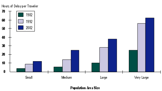
Source: In their most recent annual report on the state of congestion in America's cities, the Texas Transportation Institute noted that congestion has grown substantially over the past 20 years. While the largest cities are the most congested, congestion occurs—and has grown—in cities of every size. A more complete discussion follows later in this section. (The 2005 Urban Mobility Report, http://mobility.tamu.edu.)
The report pays particular attention to the concept of travel time reliability—how consistent travel conditions are from day-to-day—and strategies aimed at improving reliability. The variation in travel times is now understood as a separate component of the public's and business sector's frustration with congestion problems. Average travel times have increased and the report discusses ways to reduce them. But the day-to-day variations in travel conditions pose their own challenges and the problem requires a different set of solution strategies. The topics covered in this year's report include:
- Characteristics of congestion and travel reliability;
- Significance of reliability to travelers;
- Recent trends in congestion, especially reliability;
- Strategies to address congestion problems; and
- New tools and initiatives for dealing with congestion.
WHAT IS CONGESTION?
Congestion is relatively easy to recognize—roads filled with cars, trucks, and buses, sidewalks filled with pedestrians. The definitions of the term congestion mention such words as "clog," "impede," and "excessive fullness." For anyone who has ever sat in congested traffic, those words should sound familiar. In the transportation realm, congestion usually relates to an excess of vehicles on a portion of roadway at a particular time resulting in speeds that are slower—sometimes much slower—than normal or "free flow" speeds. Congestion often means stopped or stop-and-go traffic.
Previous work has shown that congestion is the result of seven root causes, often interacting with one another.
- Physical Bottlenecks ("Capacity") – Capacity is the maximum amount of traffic capable of being handled by a given highway section. Capacity is determined by a number of factors: the number and width of lanes and shoulders; merge areas at interchanges; and roadway alignment (grades and curves).
- Traffic Incidents – Are events that disrupt the normal flow of traffic, usually by physical impedance in the travel lanes. Events such as vehicular crashes, breakdowns, and debris in travel lanes are the most common form of incidents.
- Work Zones – Are construction activities on the roadway that result in physical changes to the highway environment. These changes may include a reduction in the number or width of travel lanes, lane "shifts," lane diversions, reduction, or elimination of shoulders, and even temporary roadway closures.
- Weather – Environmental conditions can lead to changes in driver behavior that affect traffic flow.
- Traffic Control Devices – Intermittent disruption of traffic flow by control devices such as railroad grade crossings and poorly timed signals also contribute to congestion and travel time variability.
- Special Events – Are a special case of demand fluctuations whereby traffic flow in the vicinity of the event will be radically different from "typical" patterns. Special events occasionally cause "surges" in traffic demand that overwhelm the system.
- Fluctuations in Normal Traffic – Day-to-day variability in demand leads to some days with higher traffic volumes than others. Varying demand volumes superimposed on a system with fixed capacity also results in variable (i.e., unreliable) travel times.
National estimates of congestion by source are useful to guide FHWA's program and to identify which areas should be emphasized (Figure ES.2). However, local conditions vary widely–developing methods for estimating congestion sources on individual highways would be highly useful to transportation engineers "in the trenches" trying to decide how to craft mitigation strategies. FHWA is currently researching this issue and is developing a methodology to allow transportation engineers to estimate the sources' contribution to total congestion using local data.
Figure ES.2 The Sources of Congestion
National Summary
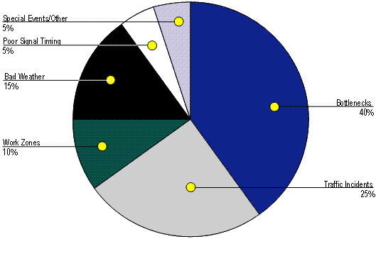
Source: https://ops.fhwa.dot.gov/aboutus/opstory.htm
Congestion results from one or more of the seven sources on the highway system. The interaction between multiple sources is complex and varies greatly from day-to-day and highway-to-highway. The problem is that with the exception of the physical bottlenecks, the sources of congestion occur with maddening irregularity—nothing is ever the same from one day to the next! One day commuters might face low traffic volumes, no traffic incidents, and good weather; the next day traffic might be heavier than normal, it might be raining, and a severe crash may occur that blocks lanes on the roadway.
As if the congestion picture was not complicated enough, consider further that some events can cause other events to occur. For example:
- Abnormally high congestion can shift traffic to other highways or cause travelers to leave later, go to other destinations, or choose not to go at all.
- High congestion levels can lead to an increase in traffic incidents due to closer vehicle spacing and overheating of vehicles during summer months.
- Bad weather can lead to crashes.
- The traffic turbulence and distraction to drivers caused by an initial crash can lead to other crashes.
Because of the interconnectedness of the sources, significant payoffs can be expected by treating them.
In addition to causing delay to travelers, the sources of congestion also produce another effect: variability in congestion conditions. This variability in congestion is known as travel time reliability, in other words, how "reliable" travel conditions are day-to-day, and is of intense interest for transportation professionals dealing with congestion.
THE IMPORTANCE OF TRAVEL TIME RELIABILITY
Congestion has not only grown over the past two decades, it has become more volatile as well. Congestion levels are never the same from day-to-day on the same highway because the variety of traffic-influencing events that influence congestion are never the same. Because travel conditions are so unreliable on congested highways, travelers must plan for these problems by leaving early just to avoid being late. This means extra time out of everyone's day that must be devoted to travel—even if it means getting somewhere early, that's still time we could be using for other endeavors. Commuters could be late for work or after-work appointments, business travelers could be late for meetings, and truckers could incur extra charges by not delivering their goods on time. And all because of unreliable travel conditions on our highways!
What is Travel Time Reliability and What Are Its Causes? Travel time reliability is defined as how much travel times vary over the course of time. This variability in travel times from one day to the next is due to the fact that underlying conditions vary widely. The seven sources of congestion—especially traffic-influencing "events" such as traffic incidents, weather, and work zones—that contribute to total congestion also conspire to produce unreliable travel times, because these are never the same from day-to-day. Transportation professionals have for many years referred to this event-driven variability in travel conditions as non-recurring congestion since it happens differently every day. Travel time reliability, then, is just a more formal way of describing what has been historically called non-recurring congestion. |
By its very nature, roadway performance is at the same time consistent and repetitive, and yet highly variable and unpredictable. It is consistent and repetitive in that peak usage periods occur regularly and can be predicted with a high degree of reliability. (The relative size and timing of "rush hour" is well known in most communities.) At the same time, it is highly variable and unpredictable, in that on any given day, unusual circumstances such as crashes can dramatically change the performance of the roadway, affecting both travel speeds and throughput volumes.
The traveling public experiences these large performance swings, and their expectation or fear of unreliable traffic conditions affects both their view of roadway performance, and how, when and where they choose to travel. For example, if a road is known to have highly variable traffic conditions, a traveler using that road to catch an airplane routinely leaves lots of "extra" time to get to the airport. In other words, the "reliability" of this traveler's trip is directly related to the variability in the performance of the route she or he takes.
HOW DO WE MEASURE TRAVEL TIME RELIABILITY?
Travel time reliability can be defined in terms of how travel times vary over time (e.g., hour-to-hour, day-to-day). Commuters who take congested highways to and from work are well aware of this. When asked about their commutes, they will say things like: "it takes me 45 minutes on a good day, but an hour and 15 minutes on a bad day" or "it takes me an additional 10 minutes if I leave 15 minutes later."
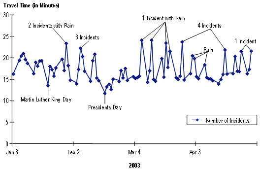
Figure ES.3 typifies this experience with data from State Route 520, a major commuter route, in Seattle, Washington. If there was no congestion on this 11.7 mile segment, travel times would be around 12 minutes; on President's Day this was the case. On other days, the average travel time was 17.5 minutes, or an average speed of 40 mph. But when events (traffic incidents and weather) are present, it could take nearly 25 minutes, or 43 percent longer than average. Commuters who take State Route 520 corridor must plan for this unpredictable variability if they want to reliably arrive on time—the average just won't do.
Figure ES.3 Weekday Travel Times
5:00-6:00 p.m., on State Route 520 Eastbound, Seattle, Washington
In other words, they have to build in a buffer to their trip planning to account for the variability. If they build in a buffer, they will arrive early on some days. This may not necessarily be a bad thing, but the extra time is still carved out of their day—time they could be using for other pursuits besides commuting.
We use this buffer to measure travel time reliability. Several statistics can be developed from this information, but we have found the Buffer Index, to be a particularly useful one. This is calculated as the extra travel time needed to accomplish a trip 19 times out of 20 chances in relation to the average travel time for that trip. In the State Route 520 example, this is: (25 minutes - 17.5 minutes)/17.5 minutes = 43 percent. Tracking changes in the Buffer Index over time indicates whether reliability is improving or degrading.
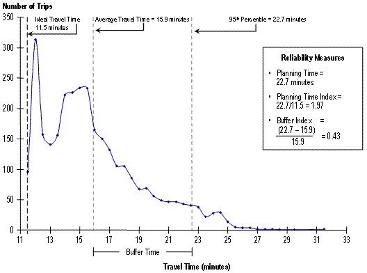
MEASURING RELIABILITY
Because reliability is defined by how travel times vary over time, it is useful to develop frequency distributions to see how much variability exists. Calculating the average travel time and the size of the "buffer"—the extra time needed by travelers to ensure a high rate of on-time arrival—then helps us to develop a variety of reliability measures. These measures include the Buffer Index, the Planning Time, and the Planning Time Index (see Figure ES.4). They are all based on the same underlying distribution of travel times, but describe reliability in slightly different ways:
- Planning Time – The sheer size of the buffer (the 95th percentile travel time).
- Planning Time Index – How much larger the buffer is than the "ideal" or "free flow" travel time (the ratio of the 95th percentile to the ideal). In the 11.5-mile long corridor shown, the ideal travel time is 11.5 minutes, assuming that vehicles will travel at 60 mph when no congestion is present.
- Buffer Index – The size of the buffer as a percentage of the average (95th percentile minus the average, divided by the average).
Figure ES.4 Distribution of Travel Times, State Route 520 Seattle, Eastbound, 4:00-7:00 p.m. Weekdays (11.5 Miles Long)
WHAT VALUE DOES PROVIDING RELIABLE TRAVEL TIMES HAVE?
Improving the reliability of travel times is significant for a number of reasons:
- Improvements in reliability are achieved by reducing the overall variability due to the seven sources of congestion, mainly traffic-influencing events. In other words, improvement strategies targeted at reliability decrease the delay due traffic-influencing events (e.g., traffic incidents, bad weather, and work zones). This produces a double benefit: not only is reliability improved (by reducing the variability in travel times) but the total congestion delay experienced by travelers is also reduced. The value of saving travel time is very high for certain types of trips such as those taken by emergency responders, but just about every traveler realizes value from travel time savings.
- Reducing total congestion saves time and fuel, and leads to decreased vehicle emissions.
- Addressing three of the major components of unreliable travel—traffic incidents, bad weather, and work zones—also leads to safer highways. By reducing the duration of these events, we are reducing how long travelers are exposed to less safe conditions.
- Commuters as well as freight carriers and shippers are all concerned with travel time reliability. Variations in travel time can be highly frustrating and are valued highly by both groups. Previous research indicates that commuters value the variable component of their travel time between one and six times as much as average travel time. And the increase in just-in-time (JIT) manufacturing processes has made a reliable travel time almost more important than an uncongested trip. Significant variations in travel time will decrease the benefits that come from lower inventory space and the use of efficient transportation networks as "the new warehouse." Therefore, in both the passenger and freight realms, evidence suggests that travel time reliability is valued at a significant "premium" by users.
- Reducing congestion at international border crossings leads to lower transportation costs and benefits the national economy as a whole. Further, reducing congestion on U.S. highways for freight moving between Canada and Mexico fosters international trade. Therefore, congestion on U.S. highways has a large influence on the efficiency of international trade.
CONGESTION AND RELIABILITY TRENDS
Examination of the available data on congestion and highway usage over the past decade leads to the conclusion that congestion is getting worse. Highway usage has been growing at roughly two percent per year and is expected to continue doing so. On highways that are already congested, any additional traffic leads to a disproportionately higher amount of congestion—once traffic flow has broken down to stop-and-go conditions, adding more vehicles makes recovery very difficult.
Congestion Is Getting Worse
A good source for monitoring congestion trends is produced annually by the Texas Transportation Institute (TTI).1 In their 2005 report, TTI's researchers found that congestion levels in 85 of the largest metropolitan areas have grown in almost every year in all population groups from 1982 to 2003. Average urban congestion trends from 1993-2003 include the following:
- Peak-period2 trips take an average of about seven percent longer.
- Travelers spend 47 extra hours per year in travel compared to 40 hours in 1993.
- The percent of freeway mileage that is congested has grown from 51 percent to 60 percent.
Congestion has clearly grown. Congestion used to mean it took longer to get to/from work in the "rush hour." It used to be thought of as a "big city" issue or an element to plan for while traveling to special large events. There was some "slower traffic" in small cities, but it was not much more than a minor inconvenience. The problems that smaller cities faced were about connections to and between cities, manufacturing plants, and markets.
Consider the following four characteristics of congestion trends, as shown in Figure ES.5:
- Congestion affects more of the system. You might encounter stop-and-go traffic on any major street or freeway. Congestion effects have spread to neighborhoods, where cities and residents have developed elaborate plans and innovative techniques to make it harder for commuters to use the streets where kids play as bypass routes for gridlocked intersections.
- Congestion affects more time of the day. We are not just seeing these problems in the "rush hour." Peak periods typically stretch for two or three hours in the morning and evening in metro areas above one million people. Larger areas can see three or four hours of peak conditions. These are just the average conditions. Many cities have a few places where any daylight hour might see stop-and-go traffic. Weekend traffic delays have become a problem in recreational areas, near major shopping centers or sports arenas, and in some constrained roadways.
- The extra travel time penalty has grown. It just takes longer to get to your destination. Not just work or school, but shopping trips, doctor visits, and family outings are planned around the questions "How long do I want to spend in the car, bus, or train?" and "Is it worth it?" Peak-period trips required 37 percent more travel time in 2003 than a free flow trip at midday, up from 28 percent 10 years earlier.
- Non-recurring congestion exerts a greater influence on total congestion. As the physical capacity of our roadways is consumed by the growth in traffic we've seen over the past 20 years, they also become more vulnerable to disruptions caused by traffic-influencing events such as traffic incidents, bad weather, and work zones. Further, these events can occur at any time and in places that don't usually experience congestion, thereby spreading congestion to more roadways and more times of the day.
Figure ES.5 Weekday Peak-Period Congestion Has Grown in Several Ways in the Past 20 Years in Our Largest Cities
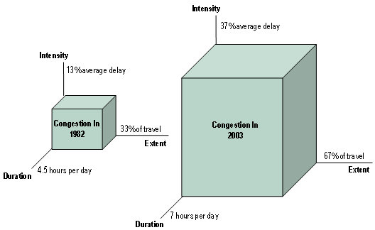
Source: Analysis of data used in 2005 Urban Mobility Report, Texas Transportation Institute.
Travel Reliability Is Also Getting Worse
Changes in reliability could be considered a fourth characteristic of congestion trends. The extra travel time and amount of the day and system affected by travel delays is not the same every day. It may not even be as it was predicted 10 minutes ago.
- 1982 – If your midday trip took 20 minutes, it would take you 23 minutes in the peak. Although no reliability statistics exist from that long ago, analysis of recent data suggest that you would have to add an additional nine minutes to that trip to guarantee on-time arrival at your destination; a total of 32 minutes might be planned for that trip.
- 2003 – By 2003, that 20-minute free-flow trip took 28 minutes. And if on-time arrival was important you should allow 40 minutes for the trip.
Only in the last few years have the data been available to assess travel time reliability. Atlanta, Georgia is a city with both a history of detailed traffic monitoring data and significant congestion. Table ES.1 shows that travel times grew increasingly unreliable in several highly traveled freeway corridors over a four-year period. This is indicated by increases in the Buffer Index; as it rises, travel times become more unreliable.
| Atlanta Freeway Corridor | Buffer Index | |||
|---|---|---|---|---|
| 2000 | 2001 | 2002 | 2003 | |
| I-75A, NB (I-285 to I-20, 7.72 miles) | 21% | 29% | 33% | 35% |
| I-75A, SB (I-20 to I-285, 7.36 miles) | 12% | 22% | 25% | 33% |
| I-75B, NB (I-20 to I-85 Split, 3.73 miles) | 48% | 59% | 58% | 100% |
| I-75B, SB (I-85 Split to I-20, 4.04 miles) | 24% | 36% | 32% | 56% |
| I-75C, NB (I-85 Split to I-285, 8.95 miles) | 30% | 39% | 32% | 35% |
| I-75C, SB (I-285 to I-85 Split, 9.63 miles) | 13% | 29% | 42% | 50% |
| I-85A, NB (Camp Creek Parkway to I-75, 4.18 miles) | 6% | 1% | 1% | 3% |
| I-85A, SB (I-75 to Camp Creek Parkway, 4.05 miles) | 7% | 8% | 5% | 8% |
| I-85B, NB (I-75 to Jimmy Carter Boulevard, 14 miles) | 22% | 49% | 19% | 23% |
| I-85B, SB (Jimmy Carter Boulevard to I-75, 13.6 miles) | 41% | 37% | 31% | 34% |
STRATEGIES TO REDUCE CONGESTION AND IMPROVE RELIABILITY — FOCUS ON OPERATIONS
Transportation engineers and planners have developed a variety of strategies to deal with congestion. These fall into three general categories:
- Adding More Base Capacity – Increasing the number and size of highways and providing more transit and freight rail service. This can include expanding the base capacity (by adding additional lanes or building new highways) as well as redesigning specific bottlenecks such as interchanges and intersections to increase their capacity.
- Operating Existing Capacity More Efficiently – Getting more out of what we have.
- Encouraging Travel and Land Use Patterns that Use the System in Less Congestion Producing Ways – Travel Demand Management (TDM), non-automotive travel modes, and land use management.
All of these strategies can lead to a reduction in congestion, but it is operations strategies that have the most dramatic effect on reliability because they target the sources of unreliable travel directly. Operations strategies focus on the traffic-influencing events that both raise the general level of congestion and increase unreliable travel.
A vast array of strategies are in the transportation professional's "operations toolbox," most of which use advanced technology to identify problems, manage traffic flow, and relay travel conditions to users. Known as Intelligent Transportation Systems (ITS), these technologies enable transportation professionals to implement operations strategies targeted specifically at the causes of unreliable travel:
- Incident Management – Identifying incidents more quickly, improving response times, and managing incident scenes more effectively;
- Work Zone Management – Reducing the amount of time work zones need to be used and moving traffic more effectively through work zones, particularly at peak times;
- Road Weather Management – Prediction of weather events (such as rain, snow, ice, and fog) in specific areas and on specific roadways, allowing for more effective road surface treatment;
- Planned Special Events Traffic Management – Pre-event planning and coordination and traffic control plans;
- Freeway, Arterial, and Corridor Management – Advanced computerized control of traffic signals, ramp meters, and lane usage (lanes that can be reversible, truck-restricted, or exclusively for high occupancy vehicles);
- Traveler Information – Providing travelers with real-time information on roadway conditions, where congestion has formed, how bad it is, and advice on alternative routes; and
- Value Pricing Strategies – Proactively managing demand and available highway capacity by dynamically adjusting the toll paid by users.
FHWA has strongly promoted operations for improving congestion for several years in the form of grants, education and outreach, technical tools, and standards development. State and local transportation agencies, who are responsible for implementing transportation improvement projects, have embraced operations as a key part of their solutions. Operations strategies in the above categories have been effectively deployed around the country to decrease congestion and improve reliability. Many deployments include combinations of strategies, or congestion relief packages, which have proven to be more effective than simply deploying individual strategies. Several of the more significant recent deployments include:
- Arterial Management. Road Commission of Oakland County (RCOC) FAST-TRAC Project – Advanced Traffic Signal Coordination. Oakland County, located just north of Detroit, began implementation of the FAST-TRAC (Faster and Safer Travel through Traffic Routing and Advanced Controls) system in 1992. The key element of FAST-TRAC is the Sydney Coordinated Adaptive Traffic System (SCATS), an advanced adaptive signal system with the capability to adjust signals on an individual intersection, corridor, and areawide basis. The system detects real-time demand on the highways and continuously adjusts signal timing to meet the demand. The result is that FAST-TRAC reduces congestion by eliminating unnecessary stops and providing green phases where the demand is highest.
- Freeway Management and Incident Management. Wisconsin District 2 Freeway System Operational Assessment (FSOA) Program – Integrated Congestion Relief Strategies. During the 1990s Wisconsin DOT's District 2 implemented a freeway management system in Milwaukee. The freeway management center, field equipment, and central computer system are known as the MONITOR system. Expansion continued into the early 2000s until most of the Milwaukee area's major freeways were covered with detectors along 130 miles of freeway, 18 cameras located at major interchanges, 20 Dynamic Message Signs to communicate with motorists, over 80 ramp meters, freeway service patrols, and trailblazer systems to aid in rerouting traffic during traffic incidents, construction, and other emergencies. The program is coordinated with several other related efforts including WisDOT's statewide SmartWays Program and the Gary-Chicago-Milwaukee Corridor Coalition (GCM). The ramp meters keep the freeway operating at steady flow for longer periods of time than otherwise could be expected. The service patrols and cameras allow for quicker identification of and response to incidents, a major source of unreliable travel.
- Incident Management. Maryland's Coordinated Highway Action Response Team (CHART) – Statewide Traffic Incident Management. Maryland developed the Coordinated Highway Action Response Team (CHART) in the mid 1980s as an effort to improve travel to and from the state's coastal area. Years later, this system has evolved into a statewide operations tool that collects, processes and broadcasts traffic information. Data are collected through a communications infrastructure, a closed-circuit television system, and sensor detection system. The information is then used to make real-time traffic management decisions and provide motorists with information through dynamic message signs, radio travel advisories, and a telephone advisory system. Travelers may also access an interactive on-line GIS mapping service for major roads to obtain average speed, traffic conditions, and lane closures due to weather or construction activities. In addition, travelers can view selected road conditions through on-line video links. By reducing the duration of incidents and providing travelers with advanced warning of their locations, travel reliability is improved.
- Corridor Management, Incident Management, and Traveler Information. Seattle's Integrated Operations Programs. The Washington State DOT has been aggressively pursuing operations-oriented improvements for many years. An innovative combination of technology, policies, and resource allocation has provided travelers in Washington with more reliable travel times, reduced collisions and more efficient use of the available funding. Key aspects of the approach include: incident management; ramp metering; short, selected capacity increases; travel conditions and commute time information; high-occupancy vehicle lanes and public transportation facilities; and readily understood performance measures. As with the Wisconsin and Maryland projects, aggressive incident management practices in Seattle reduce the delay caused by incidents and improve travel reliability.
- Work Zone Management, Corridor Management, and Value Pricing. Houston's Accelerated Construction of the Katy Freeway – The Systems Approach to Bottleneck Removal. The Katy Freeway (I-10 West in Houston) expansion project is being constructed using an innovative combination of construction and financing techniques. The project, in broad terms, results in a six-year construction program, (compared to the 12-year original schedule), provides a four-lane tollway in the middle of an expanded freeway, improves the aesthetic and landscaping treatments in the corridor, and rebuilds the existing freeway pavement and bridges.
Houston's Katy Freeway improvement project highlights an emerging and highly promising operations strategy: value pricing of managed lanes. In this approach, certain travel lanes are set aside for high occupancy vehicles, toll priced for other vehicles, or both. On the Katy Freeway, travelers in buses and carpools, currently restricted to a three-person requirement in the peak hours (2-person requirement during other hours) due to limited capacity in the HOV lane, will be able to travel in the free-flow managed lanes. All travelers will have shorter time periods of congested conditions in the peak, and should have much less stop-and-go traffic in the off-peak. The managed lanes will also provide choices—free, but congested lanes, bus or carpool use of the managed lanes for free or reduced price, and a premium pay-for-travel system that allows travelers to determine the importance of their trip and pay for faster, more reliable travel if they so choose.
PROMISING OPERATIONS STRATEGIES ON THE HORIZON
In addition to innovative projects that have already been implemented, a number of even more advanced technologies and integrated programs are in development. These programs and technologies offer great promise for addressing congestion problems in the near future. A review of several such programs and technologies follows.
iFlorida: Testbed for the Next Generation of Operations Strategies. (Freeway, Arterial, and Corridor Management; Road Weather Management; and Traveler Information). In March 2003, the Florida Department of Transportation (FDOT) was selected to participate in a highly innovative model deployment of operational strategies with FHWA. Named iFlorida, this project is based on the idea that advanced operational strategies require highly detailed traffic condition data over a wide area. Therefore, the initial stages of the project are to deploy additional traffic surveillance equipment to augment FDOT's existing information infrastructure. Once in place, the infrastructure will be used to demonstrate the wide variety of advanced operational functions to enhance traffic flow and improve security, including:
- Advanced weather information;
- Security monitoring command and control;
- Variable speed limit trial;
- Roadway diversion information;
- Statewide and central Florida traveler information web sites;
- On-board video surveillance on Orlando City buses; and
- Evacuation operations.
Integrated Corridor Management ITS Initiative. (Freeway, Arterial, and Corridor Management). Recognizing the importance of maximizing the operational effectiveness of an entire corridor, the U.S. DOT's ITS program includes "Integrated Corridor Management" (ICM) Systems as one of nine Major Initiatives. The basic premise behind the ICM initiative is that these independent systems and their cross—network linkages could be operated in a more coordinated and integrated manner resulting in significant improved operations across the corridor. As stated in the ICM vision, "metropolitan areas will realize significant improvements in the efficient movement of people and goods through aggressive and proactive integration and management of major transportation corridors." In essence, integrated corridor management consists of the operational coordination of specific transportation networks and cross-network connections comprising a corridor, and the coordination of institutions responsible for corridor mobility. The goal of the Integrated Corridor Management Initiative is to provide the institutional guidance, operational capabilities, and ITS technology and technical methods needed for effective Integrated Corridor Management Systems. Currently, the ICM initiative consists of the following four phases:
- Foundational Research;
- Operations and Systems Development;
- Model Deployment; and
- Knowledge and Technology Transfer.
Clarus Weather Initiative: Weather Prediction and Monitoring at the Roadway Level. (Road Weather Management). Clarus (which is Latin for "clear") is an initiative to develop and demonstrate an integrated surface transportation weather observation data management system, and to establish a partnership to create a nationwide surface transportation weather observing and forecasting system. The objective of Clarus is to enable weather service providers to provide enhanced information to all road, rail and transit managers, and users to reduce the effects of adverse weather (e.g., fatalities, injuries, and delay). The Clarus Initiative aims to demonstrate how an open, integrated approach to observational data management can be used to consolidate surface transportation environmental data. Surface transportation environmental data assimilated by the Clarus system will include atmospheric data, pavement and subsurface data, as well as hydrologic (water level) data.
NEXT STEPS: BUILDING THE FOUNDATION FOR EFFECTIVE TRANSPORTATION OPERATIONS
Transportation operations can reduce the growth of congestion and improve the reliability of travel conditions for highway users. By directly targeting the sources of unreliable travel through transportation operations, the chances of unexpected and extreme congestion are greatly reduced, enabling travelers to experience more consistent conditions from day-to-day. Maximizing the potential of transportation operations requires much more than just deploying advanced technology. Meeting customer expectations for safe, reliable, and secure transportation services also requires that planners and system operators coordinate better so that operations can be strategically planned and deployed; so that operations data and system information is routinely shared among system operators, service providers, and transportation planners; and so that performance is continuously monitored to provide the feedback necessary to adapt to changing conditions and properly plan for future demands. These three important aspects of transportation operations are addressed below.
COORDINATION BETWEEN PLANNING AND OPERATIONS
The operation of the transportation system and planning for the transportation system are often two detached sets of activities with different requirements and different cultures. Management and operation of the transportation system typically involves a different set of practitioners with a short-term or real-time focus, often with little consideration of how activities relate to a regional transportation systems long-term goals and objectives. Transportation planning has traditionally relied upon long-range travel needs, goals for a region, and funding constraints with little consideration of short-term and ongoing operational issues. Transportation agencies, metropolitan planning organizations (MPOs), and other stakeholders are increasingly recognizing the value of coordination and collaboration among planners and operators. Although they come from differing perspectives, transportation planning and operating agencies generally share the goal of enhancing system performance, and they can benefit from stronger linkages. The major point is that while each group has its own priorities, both planners and operators need to be involved in all phases of the project development timeline.
SHARING DATA EFFECTIVELY: USING OPERATIONS DATA FOR IMPROVED OPERATIONS
Most major metropolitan areas have advanced technologies deployed to monitor traffic conditions. The data are used in real-time to identify traffic back-ups, re-time traffic signals and ramp meters, and for estimating travel times along highway segments. The data is extremely valuable when stored and used to develop historic trends. In fact, the highly detailed nature of the data (typically collected every 20 to 30 seconds at one-half-mile intervals on freeways) allows transportation operators to conduct many types of analyses previously unavailable to the profession. Foremost among these is the estimation of reliability, which requires continuously collected data in order to build a sufficient history of how travel conditions vary over time.3 The data also provides the basis for adjusting operations control strategies such as re-timing signals, deploying additional equipment, and implementing diversion and evacuation plans.
Data sharing may take several forms. For example, operations data could be archived for analysis and used in a number of transportation planning applications, such as calibration of systems planning models, use in micro-simulation models, or for performance monitoring of the transportation system. Effective data sharing can occur in several ways:
- Develop a regional data clearinghouse;
- Coordinate data resources with transit agencies;
- Use special events to initiate new data partnerships;
- Use operations data to develop more effective performance measures and improve planning analysis tools; and
- Use archived data to inform management and operations planning.
MARKING PROGRESS THROUGH PERFORMANCE MEASUREMENT
In the last few years, transportation operators have increasingly embraced the concept of performance measurement—tracking the trends of key indicators of how the transportation system is performing. Performance measurement has been widely used in the private sector as a way to improve delivery of goods and services to customers and ultimately, the success of the enterprise. Fundamentally, this is no different from providing improved transportation services to the public—public agencies are businesses "selling" transportation service and travelers are the consumers "buying" them.
Perhaps the most significant lesson from the review of performance measurement activities over the last two decades is that all performance measures and measurement systems have evolved. The changes have been the result of legislative interests, accountability efforts, new data sources, estimation procedures, changes in knowledge about traffic conditions, and, perhaps most importantly, growth in demand for the information once reports and data are used. Transportation staff and leaders should experiment with measures, data, and presentation techniques.
CLOSING
Improved operations are a cornerstone of FHWA's efforts to improve travel conditions for highway travelers. FHWA continues to develop and compile information for transportation agencies and the public on how improved operations can effectively manage congestion. By addressing congestion by its root causes, both overall congestion levels and reliability are targeted. For more information on FHWA's congestion mitigation activities and to access the complete Traffic Congestion and Reliability Report, visit the FHWA Office of Operations web site at https://ops.fhwa.dot.gov.
- Schrank, D. and Lomax, T., 2005 Urban Mobility Report, Texas Transportation Institute.
- In most metropolitan areas, the idea of "rush hour" is obsolete—congestion happens for multiple hours on both morning and evening weekdays.
- Most of the analyses presented in Chapter 2 (and some in Chapter 3) of the main report use archived operations data.