Prototype Weather Response System (WRS) for Transportation Operations
Printable Version [PDF 1.1 MB]
To view PDF files, you need the Adobe
Acrobat Reader.
Contact: Operations Feedback at OperationsFeedback@dot.gov.
The Federal Highway Administration (FHWA) and the Missouri Department of Transportation (MoDOT) recently developed a prototype system to support weather-responsive transportation operations. The WRS obtains and presents weather information from the National Oceanic and Atmospheric Administration's (NOAA) National Weather Service (NWS) via a web-based application. MoDOT staff in Kansas City tested and evaluated the system for three months and found it to be useful in scheduling their activities and managing traffic operations before and during adverse weather.
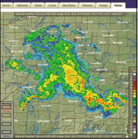
Screen shot of WRS Radar Module Display
Objectives of the WRS
The WRS was originally conceived as an information and decision support tool that will support transportation system management, operations, and maintenance prior to, and during a weather event. The tool is intended to:
- Provide real-time and forecasted weather information for operational decisions in a consolidated format tailored for transportation operations staff
- Support effective response by the transportation agency personnel to the impacts of weather on transportation system performance
- Assist transportation agencies in utilizing and evaluating weather information needs for surface transportation system management, operations, and maintenance in order to enhance safety, mobility, and productivity
The prototype WRS was designed to:
- Take advantage of operational weather data and products from the NWS as well as emerging forecast technologies such as the National Digital Forecast Database (NDFD)
- Apply the knowledge and experience gained in identifying user needs and developing decision support tools within the FHWA Road Weather Management Program
- Provide a framework for developing and demonstrating relevant road-weather products tailored for specific operational functions (e.g., traffic management, maintenance management and customer service)
- Support the operational decisions of maintenance supervisors and traffic managers during inclement weather conditions
What's in the Prototype WRS?
The prototype WRS consists of a home page and several user modules as follows:
Home Page: general description and contact information.
National: displays weather maps of the continental United
States.
State: displays weather forecasts centered on 11 central
U.S. States.
Local: displays local weather maps for metropolitan areas
in the State of Missouri.
MapShow: displays national, state, and/or local weather
maps in a series of map displays.
Planner: permits selection of a specific map location
and displays weather parameters that meet user-selected criteria. The results
are displayed in time periods for each weather parameter or can be combined
to show the time periods when all weather conditions are satisfied.
Graph: displays the results of the Planner module as a
time-series graph.
Radar: allows selection of NWS Doppler radar images or
loops from any radar station around the nation.
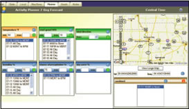
Figure: Screen shot of Planner and Graph
The Planner and Graph
The WRS Planner allows the user to select a specific location on the map, as shown on the figure on the left. For this example, the location selected is Kansas City. The user can specify any scale for a given location from a city level to a specific street location. The weather conditions, in this example, are temperature at or above 50 degrees F, wind speed at or below 10 MPH, humidity at or below 75%, and chance of precipitation at or above 75%.
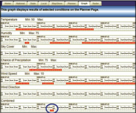
Figure: Screen shot of WRS Graph module
The time periods below each weather parameter represent when individual criteria will be met. In the combined box below the map, the time period shown represents when all of the conditions will simultaneously be met.
The WRS Graph module, the figure to the right, displays the parameters selected and time periods obtained from the Planner. As shown by the blue circle, the combined date and time correspond to the "combined" time period in the Planner. This kind of detail can help operations staff to better plan for and react to specified weather conditions.
WRS Testing and Evaluation
The prototype WRS was tested and evaluated for three months by MoDOT staff in Kansas City. Some enhancements to the original version were made during this period. Additional recommendations received from the evaluations include the ability to e-mail or transmit a page containing forecast data; long-range weather forecasts (greater than 7 days); storm tracking capability; information on precipitation type and rate, lightning locations, frost, pavement temperature and river crests; and customizable weather displays. There is also a need to add more decision support capabilities to the system by combining rules of practice for traffic control, maintenance, and operations with road weather information to recommend appropriate management strategies. These enhancements are necessary to make the system truly useful for weather responsive transportation operations and before it can be deployed to transportation agencies.

U.S. Department of Transportation
Federal Highway Administration
Road Weather Management
HOTO-1, Room 3408
400 Seventh Street, SW
Washington, D.C. USA 20590
For additional information, contact:
Roemer Alfelor, FHWA
Phone: 202-366-9242
Fax: 202-366-3225
Roemer.Alfelor@dot.gov
Warren Roberts, MoDOT
Phone: 816-622-0427
Fax: 816-622-0440
Warren.Roberts@modot.mo.gov
![]()
FHWA Publication No. FHWA-HOP-06-106
EDL No. 14292