Weather Responsive Management Strategies (WRMS)—Minnesota DOT Case Study
Printable version [PDF 1.5 MB]
You may need the Adobe® Reader® to view the PDFs on this page.
Contact Information: Operations Feedback at OperationsFeedback@dot.gov

U.S. Department of Transportation
Federal Highway Administration
Office of Operations
1200 New Jersey Avenue, SE
Washington, DC 20590
www.ops.fhwa.dot.gov
FHWA-HOP-19-080
WEATHER-RESPONSIVE MANAGEMENT STRATEGIES CASE STUDY
Background
The Weather Responsive Management Strategies (WRMS) initiative under FHWA's Every Day Counts — Round 5 (EDC-5) program promotes the use of road weather data from mobile and connected vehicle (CV) technologies to support traffic and maintenance management strategies during inclement weather. The goal is to improve safety and reliability, as well as reduce environmental impacts on the transportation system resulting from adverse weather.
Across the nation, WRMS can be implemented to mitigate the impacts of various weather conditions. Northern States with hazardous winter weather could deploy WRMS strategies such as enhanced anti-icing and de-icing, plowing, and snow removal. Southern States with tropical weather, such as hurricanes, flooding, or low visibility, could deploy WRMS strategies such as enhanced motorist alerts and advisories or variable speed limits. As part of the WRMS initiative, more than 20 States are leveraging various communications mechanisms, sensor configurations, and software tools to generate and optimize the use of road weather data and information.
This case study describes the deployment of WRMS and the benefits achieved by the Minnesota Department of Transportation (MnDOT) using mobile road weather sensor data. MnDOT is one of the first States to implement Integrating Mobile Observations (IMO) technologies, which were deployed under the EDC-4 Weather-Savvy Roads initiative.
MnDOT's Integrating Mobile Observations Initiative
MnDOT's IMO efforts have institutionalized the acquisition, transmission, storage, and use of mobile road weather observations across the State. These sustainable and interoperable processes enhance situational awareness and reduce the costs associated with winter maintenance activities. This is achieved through a hybrid communication method using cellular communications, automated vehicle location, and Dedicated Short Range Communications (DSRC).
MnDOT's fleet of mobile data computer/automated vehicle location (MDC/AVL)-equipped vehicles includes 700 of the agency's 850 plow trucks, as well as 20 light-duty supervisor vehicles and 32 mower tractors. Mobile data collected by the fleet includes air temperature, relative humidity, surface temperature, wiper status, and brake status. Additionally, about 250 plow trucks capture camera images. Every new plow truck is equipped with Automated Vehicle Location (AVL) and cameras, which is about 57 new plow trucks per year.
Web Maintenance Decision Support System (WebMDSS)
The WebMDSS is a web-based application used by MnDOT maintenance operators and Traffic Management Center (TMC) staff to better manage roadways and resources during inclement weather. It provides road advisories, warnings, and treatment information and recommendations for road maintenance purposes, and serves as the primary resource for forecasting. The robust tool allows MnDOT staff to make more informed decisions for maintenance planning and tactical actions through detailed, hour-by-hour, weather and pavement forecasts at the maintenance route level. These informed decisions result in improved mobility and safety, as well as cost savings and reduced environmental impacts from reduced material usage.
WebMDSS has a map-based display that allows the user to drill down and investigate radar and Road Weather Information System (RWIS) information such as road segment camera images and weather plots.
Maintenance reports are also available through WebMDSS to measure progress and inefficiencies. MnDOT can compare WebMDSS reports against agency reports to confirm whether staff are using the right amount of material in the correct locations. MnDOT iteratively works to identify, understand, and address discrepancies between staff decisions and WebMDSS recommendations.
Because accurate data input is needed to produce good information, MnDOT continues to improve WebMDSS capabilities to make the tool even more robust. MnDOT is working with a vendor to enhance the tool's pavement model by adding friction readings from plow vehicles. The friction coefficient is currently available and displayed in the vehicle, but not incorporated into the pavement model for decision-making given the challenges with consuming and normalizing this type of data.
Traveler Information
Leveraging existing Integrating Mobile Observations (IMO) capabilities, MnDOT provides the public with better information to make informed travel decisions, thereby improving safety and mobility. To augment the weather condition information in the agency's 511 traveler information system, MnDOT provides road condition images taken from active plow vehicles in the field. This provides additional information on current and anticipated roadway dangers and conditions. MnDOT's dash cameras (Figure 1) automatically record images of the road ahead of the plow whenever the MDC/AVL system is on. Images are taken once every five minutes and only retained if the plow is moving at least 10 miles per hour. This is configurable and can be programmed to take images more frequently. The cameras can also take operator-initiated snapshots and video clips. Any captured video must be downloaded from the vehicle manually.
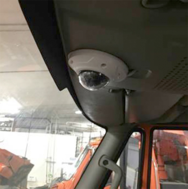
Figure 1. Ceiling-mounted snowplow camera.
(Source: MnDOT)
Plow camera images are incorporated into several aspects of MnDOT's 511 travel information system, including the desktop website, the mobile website, and the 511 App. In addition, the images are also incorporated into MnDOT's internal website, called Condition Acquisition and Reporting System (CARS). Operators use CARS and other available IMO data to increase situational awareness for posting Dynamic Message Signs (DMS) messages.
To provide images in the traveler information system, a custom filter specifies whether the image is qualified to be shared with the public. For example, images taken when a plow truck is not on a State's highway or does not meet speed criteria will not appear on the winter weather layer of the 511 website (Figure 2). Images from plow trucks are cached and made available for users to view until the truck is no longer active and turned off, at which time cached images are removed.
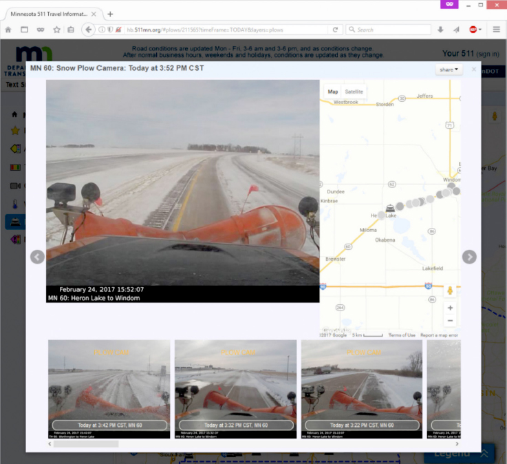
Figure 2. Plow image and map on MnDOT's 511 website.
(Source: MnDOT)
Other WRMS-Related Applications
Fleet Management and Vehicle Maintenance
MnDOT collects vehicle data from Controller Area Network Bus (CANBus) codes through its partnership with a truck manufacturer. This manufacturer interprets the CANBus codes obtained. Data collection includes maintenance information such as whether a vehicle's dash lights indicate the need for immediate or near-term service. Approximately 400 vehicles in MnDOT's fleet are equipped with the CANBus-AVL connection (Figure 3). MnDOT benefits from this application by improved monitoring of the health and performance of its fleet vehicles, enabling the agency to reduce damage to vehicles when issues arise.
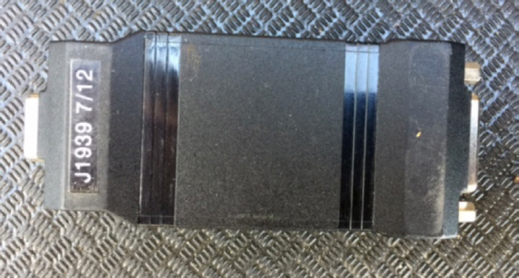
Figure 3. CANBus Interface Module.
(Source: MnDOT)
A web-based dashboard system can display vehicle status and transmit daily reports to MnDOT maintenance supervisory staff. Vehicles may be filtered according to fault severity, including degraded condition ("limp home"), stop now, service immediately, service soon, or maintenance-related. Users may also drill down to an individual health report for a given vehicle.
MnDOT has experienced some challenges with this application and is examining whether to continue this program. MnDOT plans to continue to equip new vehicles with the AVL connections, but at this time has no plans to retrofit existing vehicles.
Additional Traveler Information Enhancements
MnDOT is considering leveraging AVL data to provide a "Track a Plow" feature on its 511 system. This feature, very popular in neighboring States, would show the location of all the agency's 700 equipped plow trucks on the system, compared with only 250 plow trucks with cameras that can be viewed currently.
Asset Management
MnDOT plans to integrate IMO data with its Transportation Asset Management System (TAMS) for records automation. Conceptually, TAMS will generate a work order within the AVL through the WebMDSS interface telling the system the anticipated work to be undertaken (i.e., what, when, where, and how). Based on completion of the work, AVL data, including vehicle location, vehicle speed, chemical application rate, road and air temperatures data, operator inputs, and data recorded from the camera interface, will be used to automatically close the work order. The work order is then downloaded to MnDOT's Resource Consumption Application (RCA) to document labor, equipment, and materials. Such data are important to managers and planners. Reporting these are typically low priority for drivers, who are often focused on clearing snow and ice while ensuring their own safety and that of motorists on the road. Currently, only end-of-shift reports are available for the driver to input into the RCA.
Conclusion
MnDOT continues to build on the success of its IMO initiative by expanding its collection of road weather data and implementing WRMS and WRMS-related applications that leverage this data to achieve greater benefits. The WebMDSS leverages IMO data to provide more accurate and precise recommendations for maintenance decisions including the appropriate amounts of salt and materials to apply. The provision of road condition images from plow vehicles on MnDOT's 511 traveler information system and CARS increases the situational awareness of the traveling public and MnDOT operators to make more informed decisions. The availability of mobile observations also allows the agency to better manage its vehicle fleet and assets during weather events. Overall, these efforts result in safer roadways, increased mobility, reduced environmental impacts from salt use, and a reduction in agency costs due to less material usage and increased efficiencies with staff time.
Available Resources
FHWA's EDC-5 WRMS Resource Website:
https://collaboration.fhwa.dot.gov/dot/fhwa/RWMX/SiteAssets/WRMS/home.aspx
FHWA's EDC-4 IMO Resource Website:
https://collaboration.fhwa.dot.gov/dot/fhwa/RWMX/SiteAssets/Weather%20Savvy%20Roads.aspx
Integrating Mobile Observations (IMO) 3.0 in Minnesota Final Report:
https://collaboration.fhwa.dot.gov/dot/fhwa/RWMX/Documents/MnDOT%20IMO%203%20Final%20Report%20-%20Nov%202017.pdf
For additional information, please contact:
David Johnson
david.johnson@dot.gov
(202) 366-1301
Joe Huneke
joseph.huneke@state.mn.us
(651) 366-3586