Weather-Savvy Roads:
Leveraging Multiple Communications Systems for Vehicle-Based Data Sharing: Nevada Department of Transportation Case Study
Printable version [PDF 878 KB]
You may need the Adobe® Reader® to view the PDFs on this page.
Contact Information: Operations Feedback at OperationsFeedback@dot.gov
U.S. Department of Transportation
Federal Highway Administration
Office of Operations
1200 New Jersey Avenue, SE
Washington, DC 20590
www.ops.fhwa.dot.gov
FHWA-HOP-18-030
INTEGRATING MOBILE OBSERVATIONS CASE STUDY
Background
The Weather-Savvy Roads effort deploys two distinct road weather management solutions that allow State and local agencies to proactively manage the surface transportation system ahead of and during adverse weather events: Pathfinder and Integrating Mobile Observations (IMO).
Departments of Transportation (DOTs) face challenges sending and receiving data from mobile fleets to center-based resources due to cost and limitations of existing wireless services. IMO promotes the collection of mobile weather, road, and vehicle data from agency fleets to improve situational awareness of road conditions. This case study reviews the Nevada DOT approach to leverage radio, cellular Wi-Fi, and Dedicated Short Range Communications (DSRC) for sending IMO data to cloud resources and the Nevada Data Exchange (NDEx).
Nevada DOT's Approach—Using a Hybrid Communications Platform for IMO
Since 2011, the Nevada DOT has been conducting phased piloting of the IMO program. Its goal is to improve safety, reliability, and mobility of Nevada's road system during winter weather events. Throughout its work on the program, the Nevada DOT has tested and advanced communication technology for transmitting road weather observations. During Phase I, Nevada used Enhanced Digital Access Communication System (EDACS) radio for communication. In Phase II, cellular capabilities were added and often replaced EDACS. In Phase III, DSRC were added to cellular-equipped vehicles.
| Technology |
Phase |
DSRC. DSRC are used by on-board units (OBUs) in equipped vehicles to communicate with each other, with roadside units (RSUs), and with the transportation management center (TMC) or cloud resource. DSRC use licensed spectrum (5.9 GHz) wireless communications to send and receive WAVE short message protocol (WSMP) or internet protocol version 6 (IPv6). DSRC use low latency communications. They have a range of about 300 meters and a speed around 6 Mbps for optimized use in connected vehicles. |
III |
Cellular. Cellular is a flexible approach to communicate with relatively high speed. It has a monthly reoccurring cost, limited availability, and data volume restrictions. While cellular coverage has become more widely available, there are still several roads maintained by NDOT that do not have cellular coverage. |
II and III |
Wi-Fi. Wi-Fi works well for areas like fuel points or maintenance garages. It has limited range, but high speeds, so it can be ideal for store-and-forward types of communications with data that are not time sensitive. It also does not have data volume limits or monthly costs like cellular. |
II and III |
EDACS Radio. EDACS uses a statewide 800 MHz radio system to communicate with maintenance personnel. This system allows each vehicle to transmit approximately 500 bytes every five minutes. Vehicles send basic telemetry information, but they are not able to send the full data set needed by most IMO deployments due to limited bandwidth. As of 2017, this system is considered antiquated, and plans for a replacement are being made. However, it is currently in use across the State where no other communication modes are present. |
I |
In Phase III, the Nevada DOT instrumented nine snow plows and one service patrol vehicle with DSRC and cellular communications technology to collect road weather information in the Reno, Carson City, and Lake Tahoe areas. Each equipped vehicle is able to switch to the most effective technology mode depending on its location. Eighteen DSRC sites cover 32 miles of roadway along routes 395 and 580, with varying coverage density connecting Reno and Carson City. There are clusters of continuous coverage and more sparsely separate "drive-by hotspots" for data transfer. An additional 54 miles of roadway are covered via cellular connectivity along mountain pass roads extending towards Lake Tahoe over Mt. Rose (SR–431) and Spooner Summit (U.S. 50). These locations have more extreme winter weather.
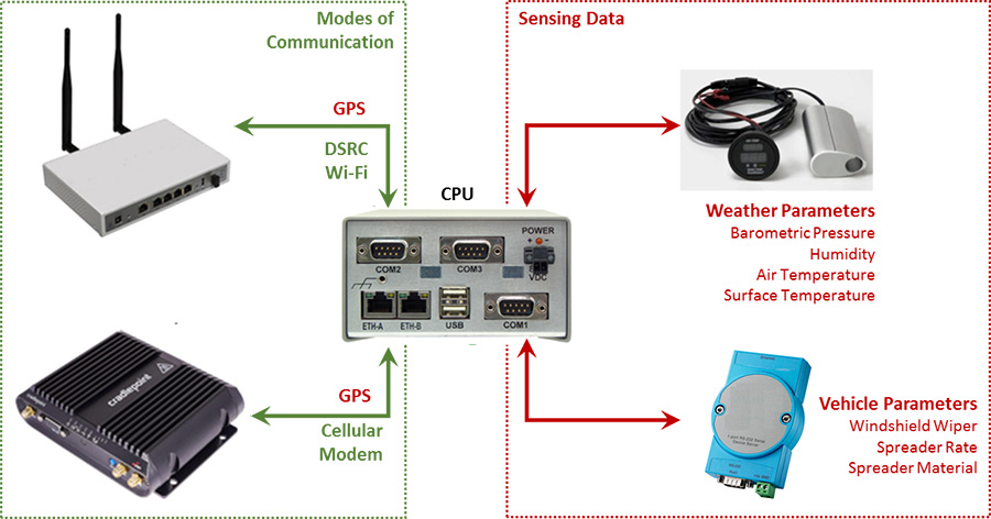
Within each IMO-equipped vehicle, the following system components are in place (Figure 1 below). Managed by the central computer, the in-vehicle system gathers location, vehicle, and weather data; formats the data; and transmits the data using DSRC or cellular communications and Wi-Fi based on availability and need.
Figure 1: Diagram adapted from Nevada DOT displaying modes of communication. (Source: Nevada DOT)
Why use a hybrid communications platform?
A major benefit of deploying a hybrid communications platform is enhanced systemwide awareness and performance monitoring that enables improved highway maintenance operations and equipment maintenance. Although data is transmitted using the best available mode, DSRC are prioritized and used whenever possible because of cost and speed. DSRC communicates with the in-vehicle network that connects with existing environmental sensors. Wi-Fi hotspots are utilized where available outside of DSRC regions. Cellular is used in sections where DSRC and Wi-Fi are not available. In areas where DSRC, Wi-Fi, and cellular are not available, data is stored on the vehicle until communications are reestablished.
Technical Approach and System Design
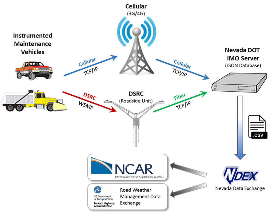
DSRC allows equipped vehicles to participate in Vehicle-to-Infrastructure communications at highway speeds. The vehicle network communicates with the NDEx to transmit weather and road data. In areas where DSRC roadside devices exist, equipped cars send probe data or environmental log files to the Nevada DOT IMO server. In areas where connected automobile infrastructure does not exist, cellular communications send the environmental information. Figure 2 shows the network connection for DSRC and cellular. WSMP over DSRC is referring to WAVE short message protocol, which is a lightweight method of sending small messages (probe in this case). Fiber is used for the network connection between the roadside unit and the IMO server. Transmission Control Protocol/Internet Protocol (TCP/IP) is used for the network protocol on cellular and fiber.
Figure 2: Diagram of road weather management data exchange cellular communication. (Source: Adapted from Nevada DOT)
Challenges
When an agency designs, deploys, operates, monitors, and maintains communication technology related to their IMO program, it may need to mitigate the following challenges:
Customization challenges. Where possible, use well tested, commercially available software and hardware. Custom software and hardware are challenging to develop and test, but even more difficult to maintain. Over its three phases, Nevada's IMO project worked towards the use of a modular design with industrial-grade, commercial-off-the-shelf (COTS) components whenever possible. Although a custom designed system (Phase II) is less expensive in terms of initial costs, the long-term costs of a modular COTS system are lower, as it is less necessary to maintain personnel with the skill sets to design, build, operate, and maintain the hardware and software elements. While the COTS -based system will involve a significant amount of custom software development at first, once the system is in place, these costs will be significantly reduced to maintenance and upgrades.
Networking infrastructure. Involve IT personnel with networking expertise, as the telemetry paths work through the DOT network. During initial setup, Nevada's IMO team experienced numerous networking challenges related to component configuration, addressing, and firewalls. These took time to navigate, and IT personnel were essential for this task.
Security. Anytime vehicles are communicating with back end data services, security needs to be considered. A firewall at the back end can be used to protect the servers and provide virtual private network (VPN) services to remote vehicles, allowing them to communicate securely over the internet (using a cellular modem). RSUs can either VPN to the back end firewall or be installed on a private network to send DSRC messages to the back end servers. The vehicle network also needs to be hardened. This can be done with removing unnecessary services by using two-factor authentication and encrypted communication.
IPv6. Most DOT networks use internet protocol version 4 (IPv4). To run DSRC natively, IPv6 is needed. Not all Nevada DOT IMO component devices support IPv6. This requirement was circumvented using WSMP from the vehicle to the RSU and then using IPv4 to the back end servers. It may also be possible to use IPv4 over IPv6 tunneling.
Multimodal data telemetry features. Nevada's IMO system uses a multimodal telemetry system that selects the best mode, depending on the vehicle's location. Challenges were found in establishing reliable geofencing rules, especially as this is related to handling data packet receipt confirmations and (as needed) retransmission as the vehicle moves in and out of telemetry mode zones. This is more complex when the vehicles are frequently moving through different telemetry mode zones.
Computing platforms. Each project phase used a different in-vehicle central CPU device. All three hardware systems operated using the robust Linux operating system, readily used on embedded microcomputers. In Phases II and III, secondary microcontrollers were used based on Arduino (Phase II) and Linux (Phase III). Familiarity with Linux-based embedded systems is a useful skill set for system management and is essential for system development. If not available within the DOT, consultants with these skills can be enlisted. At the back end of the system, Nevada used a physical server system during its development stages, and shifted to a virtualized windows machine at the DOT once the system became fully functional. The virtualized system simplifies management for the Nevada DOT's IT group.
DSRC message formats. Nevada's IMO system uses WSMP messaging through DSRC. This must be converted to TCP/IP once the messages reach the backhaul (fiber or cellular from the RSU to the IMO server). It would be valuable to further investigate DSRC message type protocols to decide on a better approach to a multimodal telemetry system (e.g., Basic Safety Messages).
Cellular plan costs and coverage. Cellular data plans involve costs that can (with an appropriate data plan and qualifying data modem devices) share data usage across many devices. This type of plan is more economical than the typical flat fee per device per month plan. Another consideration is location. In rural areas of Nevada, different service providers provide different coverage.
Costs of equipment wear and tear. Phases I and II of Nevada's IMO project experimented with a range of sensor and electronic hardware components of a variety of costs, complexities, and build quality. Normal "wear and tear" in the environment of a snow plow is understandably demanding, and the equipment used in Phase III is justifiably rugged and industrial in nature. Consumer grade components (such as cell phones) should not be used for this and other reasons.
Time constraints. Vehicle installations were time-consuming during the Nevada IMO deployment. Plan for deployments during light times of the year.
Limitations in rural coverage. DSRC are a short-range technology that provide vital communication when available; however, they can be expensive to deploy in rural areas. They have an effective range of 300 meters at highway speeds, which leads to longer caching times and additional delays getting information to center resources.
Controller Area Network Bus (CANBus) connections. A functionality no longer supported in Phase III is the monitoring of on board diagnostics (OBD)/CANBus sources. While this was effectively demonstrated during earlier phases of Nevada's project, a large fraction of the fleet uses plows that are not equipped with CANBus capability (J1939). Those that are equipped have significant vehicle-to-vehicle variations in which data parameters are available. The core of an OBD/CANBus data monitoring capability is available, but until the Nevada DOT's fleet becomes uniform and modern (which is happening gradually), these data sources require a higher degree of engineering effort to monitor.
Remote access. It is valuable to incorporate an autonomous or semi-autonomous capability to remotely push software updates to OBUs and RSUs. Without this capability, it becomes necessary to make physical trips to widely distributed vehicles and field installations to perform all maintenance and updates.
Communication standards. While using standards can add project complexity, using them whenever possible provides value over the life of the project. The Nevada IMO project used the Society of Automotive Engineers J2735 (DSRC), National Transportation Communications for ITS Protocol 1204 (Environmental Sensor Station), National Marine Electronics Association 0183, and Traffic Management Data Dictionary.
Roles and Responsibilities
Leadership. When planning a project of this complexity, having the right leadership is essential. The Nevada DOT noted the following three key leadership roles:
DOT project owner and management. Sell the project value to internal and external stakeholders.
A technical champion to ensure the project technically delivers.
A trainer for users to receive maximum benefit.
Information technology. During planning, it was essential for the Nevada DOT to engage with its IT team, as IT personnel were responsible for updating infrastructure, firewalls, IPv6 communications, and VPNs. Having a good working relationship with the IT team was necessary given the project's heavy reliance on existing data center services and communications systems and the need to extend current IT system capabilities.
Fleet management. Fleet managers serve a critical role in adoption and training. As with many new intelligent transportation systems technologies, IMO can be difficult to roll out and leverage. The fleet manager leading the training and being a project champion is essential.
Conclusion
Hybrid communications reduce cost, leverage existing connections, and improve IMO data access to the TMC. DSRC RSUs and OBUs are being deployed for driver safety and information dissemination to drivers, and can be used as a cost-effective solution to augment existing remote communication solutions to bring timely information to the TMC about road and atmospheric conditions.
Available Resources
FHWA's Weather-Savvy Roads IMO Toolkit:
https://collaboration.fhwa.dot.gov/dot/fhwa/RWMX/SiteAssets/Weather%20Savvy%20Roads.aspx
For More Information
www.fhwa.dot.gov
Gabriel Guevara, FHWA
gabriel.guevara@dot.gov
(202) 366-0754
Rod Schilling, Nevada DOT
roschilling@dot.nv.gov
(775) 888-7863