Modeling a Multi-Modal Megaregion: Arizona's Sun Corridor Sheds Light on What Drives Industry and Freight
Printable Version [PDF 447 KB]
You may need the Adobe® Reader® to view the PDFs on this page.
Contact Information: Operations Feedback at OperationsFeedback@dot.gov

U.S. Department of Transportation
Federal Highway Administration
Office of Operations
1200 New Jersey Avenue, SE
Washington, DC 20590
FHWA-HOP-17-032
December 2017
BACKGROUND AND CHALLENGE
The Arizona Sun Corridor megaregion encompasses portions of five counties that include the regions served by the Maricopa Association of Governments (MAG) and the Pima Association of Governments (PAG). This region is home to approximately eight out of ten Arizonans and includes one of the busiest freight ports on the U.S.-Mexico border. State and local transportation planners in the region have been maintaining state-of-the-practice truck transportation models for many years. However, these models focus primarily on specific metropolitan planning areas. As such, they lack the capability to provide a description of freight flowing through the megaregion.
APPROACH
Grant Recipient Agency: Maricopa Association of Governments
Location: Arizona
Duration of Activity: 2014 to 2016
Budget: $350,000 from SHRP2 and $471,000 in matching funds
To improve the megaregion's ability to describe and analyze freight flows, MAG, PAG, and the Arizona Department of Transportation (ADOT) collaborated to research behavior-based freight modeling and develop a regional model that can be integrated into area and statewide travel forecasting models. The project team worked in close coordination with Federal, State, and local agencies, and received input and support from both a Technical Advisory Group (TAG) and a team of consultants. Major project objectives included:
- A comprehensive review of freight data sources with emphasis on accessible data and analysis.
- Development of innovative models.
- Development of an operational, multimodal freight model for the megaregion.
- Emphasis on a behavioral approach to model development, to inform coordinated policy development and serve as an effective tool for identifying means to improve freight operations.
- Consideration of an activity-based passenger modeling framework for MAG data in order to facilitate future integration of the models.
The model was developed in three hierarchical "layers" that covered financial, logistical, and transportation networks. Interaction between these layers is shown in Figure 1.
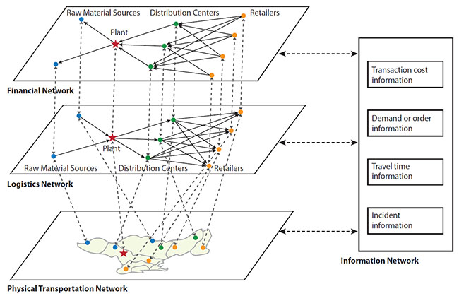
The project team also developed a series of models to represent each of the three layers:
- The financial layer is represented by a firm synthesis model, which looks at production, consumption, the evolution of freight buyers and suppliers (i.e., firms), and the various factors that influence the birth, growth, location, and dissolution of these firms. The purpose of this model is to estimate how firms change over time and space.
- The logistics layer is represented by a supplier selection model that determines the "behavior" of goods movement between entities. This layer generates a view of the "buyers" and "suppliers" of all shipments.
- The physical transportation layer is represented by two models: a supply chain model that describes how goods are moved from origin to destination and a truck tour model that captures behaviors (i.e., making multiple deliveries in a single day) exhibited by trucking patterns in the region.
BENEFITS AND IMPACTS
Key elements that contributed to project outcomes and subsequent impacts include:
- An existing working relationship between project partners.
- Existing relationships with relevant freight stakeholders in the region.
- Close collaboration among members of a large consultant team.
- Expertise in freight data collection and modeling.
Outputs generated by the project include:
- A comprehensive review of freight data sources.
- The products of data collection, data acquisition, and data analysis.
- Innovative, state-of-the-art models illustrating:
- Firm synthesis.
- The supply chain.
- Truck touring patterns (including separate models for different user classes).
- An operational, megaregional freight model readily available to support statewide and regional transportation planning processes.
Benefits
Benefits realized from this project include the ongoing use of the resources it created as well as the changes it may influence in stakeholder behavior. Specific outcomes are listed below:
| Outcome | Evidence |
|---|---|
| Enhanced ability to perform scenario planning. | Traditional travel demand models do not typically allow planners to estimate impacts due to supply chain changes. The agent-based, multimodal nature of the new model provides for development of advanced application scenarios. The new model provides insight into supply chain decisions, including distribution channels, models, and shipment sizes. This capability allows planners to better understand the effect of potential mode shifts due to various scenarios, such as the development of a new regional distribution center. |
| A consistent planning platform for the region. | Benefits of this project align directly with the overall goals of the SHRP2 program, because freight planners and decisionmakers can now more consistently evaluate transportation projects impacting freight movement. The new model bridges separate models previously maintained by agencies in the region and provides a single framework for multiple agencies to work within the same temporal and spatial constraints to coordinate projects and policies. |
| Improved capability to leverage data across multiple planning applications. | The project improved and expanded the team's knowledge base, enabling next steps and opportunities that will provide the Maricopa Association of Governments, Pima Association of Governments, and Arizona Department of Transportation with a wider range of modeling and forecasting applications. Planners in the region can use the new model to identify and implement solutions to address current and future challenges. |
| Improved stakeholder awareness of the product. | Stakeholders in the region, as well as audiences nationwide, received presentations by the project team that expanded knowledge of the process and its product. |
| Well-documented, new freight data. | Through the in-depth review and analysis of existing freight datasets, the project produced a detailed list of potential assets that can be used in the model, including a description of how each can be used and where data gaps exist. Over the course of the project, new freight data were also collected. |
Impacts
Impact measures are the ultimate benefits of using a product. These are longer term, value-added impacts of the product related to saving time, money, and lives.
| Impact | Application |
|---|---|
| Advancement in the state of the practice for behavior-based freight modeling. | Among improvements to the state of the practice are the addition of a firm synthesis model that uses a well-known match algorithm and is able to estimate changes in firm demographics over time and space. The project also produced a truck tour model that includes separate models for different user classes. |
| Possible future uses of the model outside the realm of transportation planning. | Maricopa Association of Governments is evaluating future integration of the behavior-based freight models with regional economic models to provide further insight into how goods movement affects the region's economy. |
| Ability to estimate the movement of all goods, not just trucks. | The project produced a multimodal model that is an improvement on the region's existing truck-based freight model. |
MAG plans to continue and refine the model by advancing the stop identification algorithms in truck Global Positioning System data, incorporating land use and other criteria, and completing light truck data collection to improve the model's accuracy for that vehicle class. MAG also intends to fully integrate the freight model with regional transportation forecasting models. MAG hopes to develop new model functionality and future application scenarios as well as new visualization tools to use with outputs.
PARTNERSHIPS
Maricopa Association of Governments (MAG) – Led overall project management; assisted in model development; and served on the Technical Advisory Group (TAG).
Pima Association of Governments (PAG) – Provided technical support and input to the project; served on the TAG.
Arizona Department of Transportation (ADOT) – Provided technical support and input to the project; served on the TAG.
Federal Highway Administration (FHWA) – Provided coordination support as well as technical and administrative guidance.
FOR MORE INFORMATION
Vladimir Livshits
System Analysis Program Manager
Maricopa Association of Governments
Phone: 602-254-6300
E-mail: vlivshits@azmag.gov
Jeffrey Purdy
Federal Highway Administration
Office of Freight Management and Operations
Phone: 202-366-6993
E-mail: Jeffrey.Purdy@dot.gov
Learn more about the SHRP2 program, its Capacity focus area, and Freight Demand Modeling and Data Improvement (C20) products at www.fhwa.dot.gov/GoSHRP2/

The second Strategic Highway Research Program (SHRP2) is a partnership of the Federal Highway Administration (FHWA), the American Association of State Highway and Transportation Officials (AASHTO), and the Transportation Research Board (TRB). TRB completed the research, and now FHWA and AASHTO are jointly implementing the resulting SHRP2 Solutions that will help the transportation community enhance productivity, boost efficiency, increase safety, and improve the reliability of the Nation's highway system.
STRATEGIC HIGHWAY RESEARCH PROGRAM
U.S. Department of Transportation Federal Highway Administration
American Association of State Highway and Transportation Officials – Transportation Research Board
1 Xu, J., K. L. Hancock, and F. Southworth. (2003) "Simulation of Regional Freight Movement with Trade and Transportation Multinetworks," Transportation Research Record 1854. [ Return to note 1. ]