Figure 3-14. Tonnage on the Domestic Waterway Network: 2005
The United States makes use of an extensive coast line, several large rivers, and the Tenn-Tom Canal to move commodities at a very low cost per ton, albeit at relatively slow speeds.
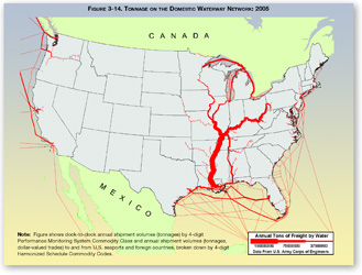
Note: Figure shows dock-to-dock annual shipment volumes (tonnages) by 4-digit Performance Monitoring System Commodity Class and annual shipment volumes (tonnages, dollar-valued trades) to and from U.S. seaports and foreign countries, broken down by 4-digit Harmonized Schedule Commodity Codes.
Source: U.S. Department of Transportation, Federal Highway Administration, Office of Freight Management and Operations, 2007; based on U.S. Army Corps of Engineers (USACE), Annual Vessel Operating Activity and Lock Performance Monitoring System data, as processed for USACE by the Tennessee Valley Authority; and USACE, Institute for Water Resources, Waterborne Foreign Trade Data.
You will need the Adobe Acrobat Reader to view the PDFs on this page.