Evaluation of Travel Time Methods to Support Mobility Performance Monitoring:
Blue Water Bridge (Page 1 of 3)
Final Site Report
April 2002
to
Office of Freight Mgt. and Operations
Federal Highway Administration
U.S. Department of Transportation
Washington, DC 20590
by
Battelle Memorial Institute
Border Crossing Freight Delay Data Collection and Analysis
FY 2001 Data Collection – Blue Water Bridge
Site Description
The Blue Water Bridge connects Port Huron, Michigan with Point Edward and Sarnia, Ontario and crosses the Saint Clair River. The bridge is near the intersection of I-94 and I-69 in the U.S., connecting with Detroit and Flint, Michigan and Chicago, Illinois. In Canada, the bridge connects with Highway 402, a major highway that connects to Highway 401 in London, Ontario, which extends from Detroit, Michigan through Toronto, Ontario and into the Eastern Provinces. The bridge facilitates the movement of many commodities between the U.S. and Canada, with the automotive and agricultural industries the most notable. The bridge operates 24 hours a day, seven days a week.
The Blue Water Bridge comprises two spans, each with three lanes. The original bridge, built in 1938, was refurbished in 1999 and handles westbound traffic into the U.S. The second span, opened in 1997, handles outbound traffic into Canada. The bridge is open for both passenger and commercial vehicle traffic 24 hours a day. The bridge is unique in that it is not jointly owned by entities on both sides but, rather, the U.S. side of the bridge is owned by the State of Michigan and operated by the Michigan Department of Transportation and the Canadian side is owned and operated by the Blue Water Bridge Authority. These two organizations seem to cooperate quite well with each other but need to maintain separate operations and maintenance staffs.
Figure 1. Area Map – The Blue Water Bridge
Data collection activities at the Blue Water Bridge occurred during June 12-14, 2001 and August 14-16, 2001. Truck travel times across the bridge in both directions were recorded on Tuesday through Thursday each week, for approximately 12 hours each day. The times of the data collection were staggered somewhat to obtain a broader picture of activity at the bridge.
Figure 2. Blue Water Bridge Plazas
Eastbound traffic (outbound to Canada) approaches the bridge either from I-94 or from a local road. The Duty Free Store is located at the intersection of the local road and the ramp to the bridge. All vehicles exiting the Duty Free Store must proceed across the bridge to Canada. Often, drivers must meet with their brokers prior to leaving the U.S. and will park along the right shoulder before the toll booths and cross the travel lanes to the brokerage building on the inbound side of the U.S. plaza. The toll booth on the U.S. side has five booths, one of which is reserved for autos with exact change or tokens. The other four booths can process either autos or trucks. Once across the bridge, autos are directed to the left and trucks veer off to the right to pass through one of four primary Customs inspection booths. Trucks are either released from primary or must continue on to secondary inspection, which could include simply completing brokerage paperwork or physical inspections of the cargo. Trucks requiring physical inspections enter an area adjacent to the buildings on the left as they exit; whereas trucks whose drivers must interact with their broker park in the areas to the right and behind the primary inspection booths. When these trucks are finally ready to depart, they must use the same roadway that trucks released from primary must use to exit the Customs compound.
Westbound (inbound to the U.S.) traffic approaches the bridge from Highway 402. During both data collection visits, there was construction work on Highway 402 in both directions beginning several miles from the bridge. Highway 402, which is a divided highway, was reduced to a single lane in each direction for a stretch of many miles. A currency exchange and public restrooms are conveniently located on the Canadian plaza and trucks often stop along the right shoulder of the road and cross the travel lanes to visit these facilities. There are typically two toll booths open for all vehicles (primarily used by trucks), one for cars and trailers, and two automated car booths. As the U.S. plaza requires trucks to stay to the left and autos to stay to the right, the Canadian Blue Water Bridge Authority restricts the flow of cars and trucks after the toll booths to the leftmost lane. This forces trucks into their desired position and allows cars to move to the right side of the bridge safety and eliminates all conflicting crossing maneuvers. This essentially creates a one-lane bottleneck on the three-lane bridge, but this did not seem to impact vehicle movement significantly. There are five booths to process commercial vehicles for U.S. Customs primary inspection; however, typically only two to four are used at any one time. Any truck not released from primary must enter the same secondary inspection compound. There are areas to park for drivers who need to visit their brokers as well as docks where physical secondary inspections can be conducted. As with the Canadian side, trucks exiting from secondary must pass through the area used by trucks exiting the primary inspection booths. Anecdotal information indicated that the limited physical space in the U.S. import compound occasionally fills up and trucks requiring secondary inspection or clearance must be held at the primary booths.
Data Collection Process
For this study, two data collection locations were used in each direction. The "number 1" location was immediately before the toll booths and the "number 2" location was immediately after the primary inspection booths. For consistency among all border crossings visited as part of the overall project, the data collection positions were distinguished by the direction of travel that they were measuring (outbound or inbound). Eastbound movement from the U.S. into Canada was referred to as outbound. Conversely, inbound was used to refer to westbound movement from Canada to the U.S. The Outbound 1 (OB-1) position; therefore, is in the U.S. plaza, before the toll booths. The Outbound 2 (OB-2) position was after the Canadian Customs booths. Inbound positions (IB-1 and IB-2) were similarly positioned. All four positions are identified in Figures 3 and 4 and shown in Figures 5 through 8.
Figure 3. US Plaza Showing Data Collection Locations
Figure 4. Canadian Plaza Showing Data Collection Locations
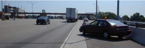
Figure 5. U.S. Toll Plaza Showing OB-1 Collection Location
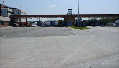
Figure 6. U.S. Customs Primary Inspection Booths as Seen from IB-2 Collection Location
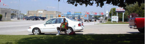
Figure 7. Canadian Toll Booths as Seen from IB-1 Collection Location
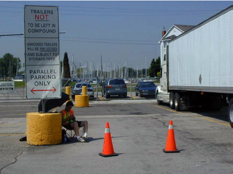
Figure 8. OB-2 Collection Location in Canadian Customs Parking Area
Each data collector would use a handheld computer to record partial license plate information of all commercial vehicles that passed their location. The computer would also store the time that each license plate was entered. The data from the two locations in each direction would be combined, allowing the determination of the travel time for each vehicle that was recorded at both locations.
For the first week of data collection, the on-site team included four data collectors and one supervisor. It was later determined that an additional supervisor was necessary to help provide additional security for any collector in a #1 position who had to leave their initial position and move away from the bridge plaza. These secondary locations were often at or near rural highway intersections and were rather isolated. The extra supervisor could also provide additional support to take over data collection when a collector was given a break or lunch.
As previously mentioned, the hours during which data were collected were varied during each week to ensure the greatest possible coverage of conditions, including periods of low and high traffic volume. Table 1 shows the data collection hours for each day during the two site visits. As each data collector actually worked about 12 hours, the supervisor could collect data during their 30-minute meal break during the day, resulting in approximately 12-½ hours of data collection.
| Date | Start | End |
|---|---|---|
| 6/12/01 | 6:00 am | 6:30 pm |
| 6/13/01 | 9:00 am | 9:30 pm |
| 6/14/01 | 9:00 am | 9:30 pm |
| 8/14/01 | 6:00 am | 6:30 pm |
| 8/15/01 | 9:00 am | 9:30 pm |
| 8/16/01 | 9:00 am | 9:30 pm |
While an extremely smooth process, it took considerable time to schedule and arrange the initial site visits to coordinate the data collection activities. Two separate meetings were held at the bridge. One meeting was held at the Michigan Department of Transportation facilities at the bridge with the Bridge Manager, the U.S. Customs Port Director, and the U.S. Customs Chief Inspector. Another meeting was held at the Blue Water Bridge Authority offices on the Canadian side. In attendance were the Operations Manager, the Special Projects Manager, and the District Director for Revenue Canada, Customs Border Services. It was determined that U.S. Customs visitor passes would need to be obtained for the data collectors from the shift supervisor when they arrived for the data collection. The names and birth dates of the data collectors also needed to be provided to U.S. Customs for the initial data collection visit. This was not required for the second data collection visit, however. No special passes were required for access to the Canadian Customs facilities.
Initial contacts with Canadian Immigration while at the bridge indicated that work permits were needed to conduct the data collection. However, consultations with Canadian Consular officials in Buffalo in preparation for data collection at the Peace Bridge indicated that that would not be necessary. The Canadian Consul General in Detroit was contacted and his staff determined that Annex 1603.A.1 of the North American Free Trade Agreement would allow our staff to enter Canada as Business Visitors without requiring work permits. All data collectors carried a copy of the e-mail from the Vice Consul as authorization for our activities. In addition, the Blue Water Bridge Authority staff communicated with the Canadian Customs and Immigration supervisors to ensure that their staff were aware of our visit.
Permission was obtained from the Michigan Department of Transportation Bridge Manager for any data collection on I-94, should that be necessary due to the formation of a queue. On the Canadian side, the Ontario Provincial Police (OPP) is responsible for monitoring activity along Highway 402, and the Blue Water Bridge Authority contacted the Sergeant in charge of the area to ensure that he was aware of the study and to obtain his permission to collect data along the highway. An additional item that required attention during the first data collection visit was contacting the foreman for the construction on Highway 402 to obtain his permission to be within the construction site.
Table 2 contains a list of the individuals who were contacted and their telephone and e-mail information. Future data collection for this project should be able to be organized and authorized with much less effort. However, any new project would require additional time to explain the data collection objectives to the involved parties and gain their approval.
| Contact | Agency | Phone/Fax | |
|---|---|---|---|
| Bruce Campbell Engineer/Bridge Manager |
Michigan DOT Blue Water Bridge |
810-984-3131 810-984-1810 (fax) |
Campbell5@mdot.state.mi.us |
| Russell Day Port Director |
U.S. Customs | 810-985-7125 ext.131 810-985-3516 (fax) |
Russell.H.Day@customs.treas.gov |
| Robert Prause Chief Inspector |
U.S. Customs | 810-985-9541 ext.117 | |
| Joe Lopetrone Operations Manager |
Blue Water Bridge Authority | 519-337-8721 519-337-5877 (fax) |
JLopetrone@bwba.org |
| Ed Teft Special Projects & Bridge Technology Manager |
Blue Water Bridge Authority | 519-336-2720 519-336-7622 (fax) |
|
| W. L. (Bill) Elliott | Revenue Canada Customs Border Services |
519-344-7351 519-336-5742 (fax) |
BillElliott@ccra-adrc.gc.ca |
| John Tennant Consul General |
Consulate General of Canada (Detroit) | 313-446-7010 ext.3200 313-567-2164 (fax) |
|
| Bob Genereux Vice Consul |
Consulate General of Canada (Detroit) | 313-446-4732 313-567-2125 (fax) |
B.Genereux@dfait-maeci.gc.ca |
| Stan Korosek Sergeant |
Ontario Provincial Police Point Edward Detachment |
519-336-8691 519-336-5011 (fax) |
|
| Ken Doussept Project Manager |
BOT Construction Limited (Highway 402 Project) |
905-827-4167 905-827-0458 (fax) 519-330-9306 (cell) |
Doussept@botconstruction.ca |