<Back to ITS in Work Zones
Intelligent Transportation
Systems
in Work Zones
A Case Study
Dynamic Lane Merge System
Reducing Aggressive Driving and Optimizing
Throughput at Work Zone Merges in Michigan
October 2004
FHWA-HOP-04-033
EDL# 14011
FHWA
Notice
The Federal Highway Administration provides high-quality information
to serve Government, industry, and the public in a manner that promotes public understanding. Standards
and policies are used to ensure and maximize the quality, objectivity, utility, and integrity of its
information. FHWA periodically reviews quality issues and adjusts its programs and processes to ensure
continuous quality improvement. |
Foreword
Dear Reader,
We have scanned the country and brought together the collective wisdom and expertise of transportation experts implementing Intelligent Transportation Systems (ITS) projects across the United States.
This information will prove helpful as you set out to plan, design, and deploy ITS in your communities. This document is one in a series of products designed to help you provide ITS solutions that meet your local and regional transportation
needs. The series contains a variety of formats to communicate with
people at various levels within your organization and among your
community stakeholders:
- Benefits Brochures let experienced community leaders explain
in their own words how specific ITS technologies have benefited
their areas.
- Cross-Cutting Studies examine various ITS approaches that can be
taken to meet your community's goals.
- Case Studies provide in-depth coverage of specific approaches
taken in real-life communities across the United States.
- Implementation Guides serve as "how to" manuals to assist your
project staff in the technical details of implementing ITS.
ITS has matured to the point that you are not alone as you move
toward deployment. We have gained experience and are committed
to providing our state and local partners with the knowledge they
need to lead their communities into the future.
The inside back cover contains details on the documents in this series,
as well as sources to obtain additional information. We hope you find
these documents useful tools for making important transportation
infrastructure decisions.
Sincerely,

Jeffrey F. Paniati
Associate Administrator for Operations
Acting Program Manager, ITS Joint Program Office
Federal Highway Administration
Preface
This case study is one in a series of documents that examines the use of
Intelligent Transportation Systems (ITS) in work zones. More information
on applications of ITS in work zones is available in the companion
document, Intelligent Transportation Systems in Work Zones –
A Cross–Cutting Study (Report No. FHWA-OP-02-025, EDL# 13600).
This case study presents information gathered during interviews with
key personnel involved with an Interstate 94 (I-94) reconstruction project
in Detroit, Michigan, as well as information and photos obtained during
a site visit. Interviewees were involved in the deployment of the dynamic
lane merge ITS application on I-94, and were also involved with other
recent deployments of the system. The authors greatly appreciate the
cooperation of the Michigan Department of Transportation, along with
their partners, which made the production of this document possible.
Contents
Project and System Background
"The use of ITS on the I-94 reconstruction
project has improved driving conditions in our area."
— Robert J. Cannon, Supervisor, Clinton Township, Michigan
The Michigan Department of Transportation (MDOT) rebuilt a large
section of I-94 in Clinton Township (a suburb of Detroit) during the
2002 and 2003 summer construction seasons. The improvements were
necessary to upgrade roadway geometry and roadside hardware, to
enhance safety and efficiency, and to rehabilitate deteriorating pavement.
This section of I-94 provides access to and within the eastern portion
of the state. The road parallels the Detroit River, a natural boundary
between the United States and Canada. The work zone on I-94 extended
from Michigan Route 102 (M-102) to Masonic Boulevard, a distance of
about 13 miles, and involved both directions of traffic.
The two-season construction project began on April 1, 2002, and ended
on September 30, 2003. The project involved 13.5 lane-miles of construction,
including bituminous resurfacing, concrete pavement repair, bituminous
freeway and concrete ramp reconstruction, lighting installation, traffic
signal installation (at the end of ramps), water main alteration, and
rehabilitation of 18 bridge structures. The total project cost was $46 million.
For the I-94 project, MDOT deployed a work zone Intelligent Transportation
System (ITS) to help smooth traffic flow and reduce aggressive driving
just prior to the transition into the construction area. MDOT selected a
dynamic lane merge (DLM) system that uses electronics and
communications equipment to monitor traffic flow and, as queuing
increases at approaches to lane closures, to regulate merge movements
and require early merging. The system, developed by International
Road Dynamics Inc., used microwave radar sensors installed on five DLM
trailers to detect traffic volume, vehicle speed, and detector occupancy.1 The system then used the data to calculate an Activity Index (a function
of volume, speed, and occupancy). When the detected conditions
surpassed the pre-set thresholds established by MDOT, the system would
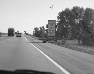
automatically activate flashing "Do Not Pass" signs. A schematic of the
I-94 DLM layout, including the five DLM trailers with sensors and flashing
signs, is shown in Figure 1. When traffic conditions no longer warranted
activation, the system remained active for five minutes and then
automatically switched to inactive mode. MDOT spaced the trailers 1,500
feet apart. The closer the trailer was to the merge point, the lower the
Activity Index was for activation. The trailer closest to the merge point
was always on. A close-up of an activated (flashing) "Do Not Pass" sign
at the I-94 site is shown in Figure 2.
 Figure 1 - DLM Layout on I-94 2
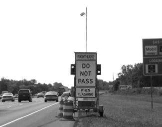 Figure 2 - Activated "Do Not Pass" Sign at the I-94 Dynamic Lane Merge Site
This ITS application was deployed on westbound I-94 in September and
October 2002, and August and September 2003. MDOT decided not to
deploy the system on the eastbound direction because the higher traffic
volumes in that direction would have made the system operate in active
mode almost all of the time. These conditions would have caused the
system to display the same messages most of the time and decreased the
value of using a dynamic ITS technology. MDOT planned to use the
system during the entire 2003 construction season, but experienced
some circuit-related electrical problems that caused deployment delays.
MDOT had used DLM previously on several other sites that included
two-to-one lane drops, while the I-94 site was the first DLM deployment
in Michigan that involved a three-to-two lane drop.
There were a number of reasons why MDOT used ITS for this major
construction project, including the following:
- MDOT anticipated aggressive driving at the merge point. As queues
build on the approach to work zone lane closures, drivers try to
avoid these queues by using storage space upstream of the closed
lane prior to the merge point. This situation is known as a "late lane
merge" phenomenon, and can create safety and mobility concerns
when drivers attempt to forcefully merge into the through lane at
the last minute.
- MDOT expected speed variability to increase as queues formed in
the through lanes, and that this could decrease traffic safety and
create a higher risk for crashes.
- MDOT identified a need to provide for smoother flow through
the merge point at the work zone approach. MDOT believed that
the traffic volumes on westbound I-94 were in a suitable range for
traffic flow to benefit from the DLM system.
The main goals of the ITS system were to:
- Reduce aggressive driving at the merge point
- Maximize available capacity at the merge point just prior to
dropping one lane out of three
- Reduce capacity losses due to increased headways at the work zone taper
- Enhance traveler safety.
Back to Top
System Design, Selection, and Implementation
This section provides information on MDOT's experience in bringing the
system from the concept stage to fully operational.
In-House or Contractor Design
- MDOT added specifications for the DLM system components as
pay items in the prime construction contract after award, as a
modification to the contract.
- The prime construction contractor hired two subcontractors to
design, install, and integrate the system components based on the
specifications that MDOT provided in the contract modification.
System Selection and Procurement
- The construction contract called for the leasing, installation and
calibration, and as-needed maintenance of all components of the
ITS system.
- MDOT included specifications in the contract for trailers, signs, and
microwave sensors.
Lease Versus Purchase
- The subcontractor leased all of the system components, as MDOT
specified in the prime construction contract. The period of performance
for the subcontractor was approximately six months during each of
two years, and included installation, testing, and operation time.
- MDOT's total cost for deployment of the DLM system was $120,000.
- MDOT wrote the specifications for temporary use of the system so
that they could deploy DLM without having to perform equipment
maintenance or store the system after construction was completed.
MDOT continues to use the lease option to benefit from the latest in
rapidly changing technology.
System Implementation
- The subcontractor developed a safety plan for placement of the
DLM system on I-94. The safety plan specified several procedures
that were used, including implementation during off-peak hours to
minimize exposure to traffic.
- Electrical problems with sensor power sources delayed deployment
early in the 2003 construction season. Sensor circuit boards were
ultimately replaced to resolve the problem.
- The project special provision for the DLM system called for wireless
communications between sensors. The specification required the
ability to communicate between sensors over a minimum distance of
five miles on an unlicensed transmission band.
- Following a one-day installation and testing period, the
subcontractor requested approval to turn the system on to traffic.
Testing
- Traffic sensor equipment required testing and calibration to ensure
adequate wireless communication between trailers in a closed loop
setting. Each trailer required access to the operational status of the
other trailers in the loop, since they operated as one system.
- The subcontractor performed preliminary testing that focused on
sensor operations and communication among sensors.
Training
- The subcontractors were responsible for all technical aspects of
the system, including equipment installation, maintenance, and
operation. MDOT did not specify any requirements for formal
training of MDOT employees on these aspects of the system as part
of the contract.
" We are pleased that this enforceable
system is being implemented to help reduce aggressive driving and improve
mobility at work zone merge areas."
— Robert J. Cannon, Supervisor, Clinton Township, Michigan
Back to Top
System Description and Operations
System Description
- The system consisted of five trailers, spaced 1500 feet apart, upstream
of the work zone.
- Each trailer included a flashing "Do Not Pass" sign, communications
equipment, and a power source. All the trailers except the one
furthest from the work zone also contained a Remote Traffic
Microwave Sensor (RTMS).
- Components relied on solar, rechargeable systems for power.
- The system used wireless radio communication equipment to allow
for communication and data sharing between trailers.
- For the DLM deployment, the only communications requirement
was to allow the sensors to communicate with each other.
In addition, the contractor was able to dial up the system from a
remote area to check the status of the system.
- In addition to the DLM system components, MDOT installed two
signs on highway entrance ramps near the work zone to alert
drivers of the no passing zone ahead. MDOT also deployed two
"Form Two Lanes Right" signs approaching the merge area,
one message board, and six static "Do Not Pass" signs as part of
the system. The message board included a script message and
visual arrow as shown in Figure 3.
 Figure 3 - Westbound I-94 Message Board
System Operations
- The sensors on the DLM system trailers detected occupancy, which is
a measure of traffic density. As congestion increases, density
increases and thus occupancy increases. The DLM system calculated
an Activity Index based on volume, speed, and occupancy. When
preset Activity Index levels were met, the system sent a signal to the
next upstream dynamic sign to be activated. The greater the
sign/trailer number, the further upstream it was from the lane
closure. The further upstream a sign was from the merge point, the
higher the activity index to trigger activation. This concept is a result
of the changes in traffic conditions, including driver behavior, forced
merges, and associated impacts to traffic flow and queuing
potential. The sign on the trailer closest to the merge point (sign 1)
was always activated.
- Activity Index thresholds are shown in Table 1. When the average
Activity Index exceeded the high threshold based on data at a sensor,
the system activated the next upstream sign and that sign stayed on
until the Activity Index at the next downstream sensor fell below
the low threshold. For example, when sensor 1 reached an Activity
Index of 15 percent or higher, the sign on trailer 2 activated until
the Activity Index for sensor 1 fell below 10 percent. Once activated,
each sign remained activated for a minimum of five minutes.
Table 1 - Sensor Settings
 |
Activity Index Threshold (%) |
Update
Period
(minutes) |
Sensor at Sign
Number |
Low |
High |
1 (Base Trailer)
Closest to the Merge |
10% |
15% |
1 minute |
| 2 |
15% |
20% |
1 minute |
| 3 |
20% |
25% |
1 minute |
| 4 |
25% |
30% |
1 minute |
| 5 |
N/A* |
- Michigan State Police (MSP) personnel were able to enforce the no-passing
zone as needed through a light on the back of each sign
panel as shown in Figure 4. When alerted by the light, officers were
aware that the sign was active and no passing was allowed.
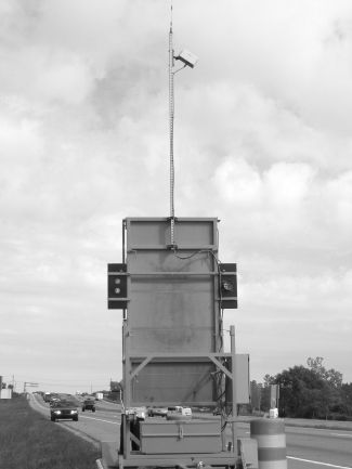 Figure 4 - Back Side of Dynamic Lane Merge Trailer Light
- The MSP assigned an officer to the I-94 work zone throughout
construction. The MSP cited active police presence as the main
deterrent to potential violators. At the I-94 work zone, officers
focused their time on monitoring traffic and responding to traffic
incidents and crashes in the work zone. No citations were written
on this project, but on other projects using the DLM system many
citations were written. Resource limitations required the officers
to focus on other areas of this construction project. Active police
presence and enforcement support successful operation of the system.
- The Concept of Operations diagram for the MDOT system is
presented in Figure 5.
 Figure 5 - Dynamic Lane Merge System Concept of Operations
Contractor or Agency Staff
- The subcontractors were responsible for operating and maintaining
the system.
Coordination with Key Personnel, Other Agencies, and the Public
- During early predeployment meetings, MDOT, MSP, and local police
personnel discussed enforcement issues. These agencies determined
that installation of a flashing light on the back of each panel would
alert Highway Patrol personnel when the system was activated and
adequately allow for enforcement of the system.
- MDOT developed a press release, radio advertisements, and
television advertisements for the project to inform the public about
the deployment of the DLM system and educate them on how to
respond to the signs.
- The public was fairly familiar with the system due to its past use by
MDOT on one other project in the Detroit area.
Maintenance
- Because the equipment was leased through the construction
contract, MDOT deployed the DLM system without having to
maintain equipment or store it after use.
- System maintenance was fairly routine and included verifying that
the sensors were operating.
Back to Top
Results
System Performance
- The system accomplished the intended objectives, and MDOT was
pleased with its performance. MDOT had several other previous
experiences with deploying the DLM system.
- Lessons learned during previous deployments helped MDOT to
develop optimal sensor settings, determine the need to increase
spacing between dynamic signs, and identify locations where use of
the system is warranted by traffic conditions.
- The system was fully operational except for a few days near the end
of construction, when a trailer malfunctioned and was permanently
in flash mode. There were no impacts to traffic based on this
malfunction. Maintenance was completed in about one day and the
system was brought back on line.
System Evaluation
MDOT has performed evaluations of selected deployments of the DLM
system in Michigan. The three-to-two merge scenario on I-94 was evaluated,
as were several previous DLM deployments in two-to-one scenarios:
- Based on observations from the I-94 deployment, MDOT estimated
that the DLM system is effective in situations where peak hour
traffic volumes are approximately 3,000 to 3,500 vehicles per hour
during construction for a three-to-two lane merge. The system is
efficient in situations where the peak hour volume ranges from
3,000 to 3,800 vehicles per hour prior to construction. Some drivers
will choose to avoid the work zone altogether, reducing the hourly
volumes during construction.
- In previous deployments of the two-to-one lane merge, MDOT
identified an effective peak hour volume range of 2,000 to 3,000
vehicles per hour.
- If the deployment site experiences higher or lower volumes than
mentioned above, the DLM system may not be effective. If volumes
are regularly lower than these ranges, a system may not be needed.
If volumes are typically higher than these ranges, the system may be
ineffective at managing queue lengths, or may be active almost
continuously (in which case the same effect could be accomplished
using static signs).
Benefits/Impacts
Results from MDOT's evaluation of the 2003 I-94 three-to-two merge
project are provided below. The full results of the evaluation are
presented in MDOT's report.3
Mobility
- The average number of stops (per probe vehicle run) in the
construction zone decreased from 1.75 to 0.96 during the morning
peak period with the implementation of the DLM system.
- The stopped time delay during both peak periods and the average
number of stops during the afternoon peak period (per probe
vehicle run) in the construction zone remained relatively unchanged.
- The average morning peak period travel time delay decreased from
95 seconds per vehicle to approximately 69 seconds per vehicle for
every 10,000 feet of travel.
- The average number of aggressive driving maneuvers per travel time
run decreased from 2.88 to 0.55 during the afternoon peak period
and was relatively unchanged during the morning peak period.
- The average travel speed increased from approximately 40 mph to
46 mph during the morning peak period and was relatively unchanged
during the afternoon peak period.
Safety
- The DLM system led to a reduction in aggressive driving and
aggressive driving maneuvers during the afternoon peak period,
therefore improving safety at the merge point.
- Crash data were analyzed for 4.3 months during construction but
without the DLM system and 2 months during construction with
DLM. Prior to system activation, there was an average of 1.2 crashes
per month. For the two-month period after the system was
implemented, no crashes were reported. The data included crashes
that occurred within the lane merge transition area.
- MDOT observed that traffic flow was disrupted less by queuing,
leading to less variance of speeds between the two lanes of traffic,
which likely reduced crash risk.
Cost Savings
- For the I-94 deployment, the system evaluator, Wayne State
University, determined that the benefits of the system (travel time
savings and vehicular fuel savings) outweighed the costs if the value
of time for delayed motorists is greater than $3.33 per hour. Wayne
State University determined this value by multiplying a monetary
value (an iterative process) by the travel time savings, adding in the
fuel savings, and then comparing this value to the actual cost of the
system. This finding showed that even if a delayed motorist's time
was only valued at a rate of $3.33 per hour, which is a low value for
user delay time, the system was cost-effective. As the value of a
motorist's time is increased from $3.33 per hour, the benefits of the
system would increase due to greater travel time savings and would
further outweigh the system costs. User delay time is usually valued
at a much greater amount than $3.33 per hour. For a relative
example of delay analysis, note that the U.S. Department of
Transportation uses an average dollar figure of $11.20 per hour for
each person in a car and $18.10 per hour for a truck driver when
calculating user cost of delay.4
Public Reception/Reaction to the System
- Through informal channels, MDOT recognized a positive perception
of the system by the public. Because the system had been deployed
previously, the public had become familiar enough with the system
to lessen the need for citations to achieve compliance with the
no-passing zone.
Obstacles Encountered and Lessons Learned
General
- The DLM system can be helpful in increasing safety and reducing
delay near work zones where lane closures are necessary.
- Sites should be wide enough to allow trailers to be moved in and
out, and allow for safe placement off the roadway. Site width is also
important for enforcement activities.
Relating with Other Agencies
- MDOT held several meetings with key stakeholders, including the
law enforcement community, to keep them involved in system
planning and design. Identifying stakeholders early in the planning
stage is one of the key steps to a successful implementation.
System Features/Capabilities
- It is better to use the DLM system on construction projects where the
work zone geometry and location do not change frequently because
such changes often require recalibrating the detectors. Long-term,
large projects may have phases that are static, where the system can
remain in place for a longer time.
- It is important to give the driving community time to adapt to the
system so that they will know how to comply with the regulatory
signs in the DLM-controlled area.
Communications
- The system requires line of sight between sensors for adequate
communication. MDOT raised antennas on the trailers due to line of
sight issues.
System Deployment
- It is important to use a proactive approach to building public
awareness of an ITS deployment. Successful techniques include
meeting with stakeholders, holding press conferences, issuing news
releases, and keeping local media up to date. MDOT used all of the
above-mentioned techniques, and also met frequently with law
enforcement early on to avoid miscommunication on overall system
objectives.
- It is necessary to allow for access to sensor stations for maintenance.
System Operations
- When changes in work zone roadway geometry are made, it is
important to allow time for drivers to learn the new setup.
- Stations may need to be reset manually when there are power
interruptions.
Maintenance
- The implementing agency can meet maintenance needs solely
through use of the vendor, or the agency can maintain the system
with initial help from the vendor. Sensor power issues caused some
small delays early on for MDOT. The system will require an adequate
system maintenance plan to avoid large amounts of system
downtime.
"The public expects us to do everything
we can to alleviate the effects of work zones, and innovative solutions
like this one are important to achieving that goal."
— Robert J. Cannon, Supervisor, Clinton Township, Michigan
Back to Top
Conclusion
MDOT has successfully deployed the dynamic lane merge system on
several projects, including I-94 in a suburb of Detroit, to help smooth
traffic flow and reduce aggressive driving just prior to the construction
area. MDOT observed a decrease in aggressive maneuvers and average
peak period travel time. These factors influenced both mobility and
safety in a positive manner, and ultimately satisfied the goals of the
deployment.
Michigan DOT contact
for this project
Jeff Grossklaus, P.E.
Construction Staff Engineer
Michigan Department of
Transportation
Construction and
Technology Support Area
P.O. Box 30049
8885 Ricks Rd.
Lansing, MI 48909
517-322-5769
grossklausj@michigan.gov
Footnotes
1 Detector occupancy is a measure of traffic density.
2 Michigan Department of Transportation (2004). Development and Evaluation of an Advanced Dynamic Lane Merge Traffic Control System for 3 to 2 Lane Transition Areas in Work Zones.
3 Michigan Department of Transportation (2004). Development and Evaluation of an Advanced Dynamic Lane Merge Traffic Control System for 3 to 2 Lane Transition Areas in Work Zones.
4 U.S. DOT (2003). Valuation of Travel Time in Economic Analysis. http://ostpxweb.dot.gov/policy/Data/VOTrevision1_2-11-03.pdf
* This sign does not transmit signals because there are no signs upstream of it.
Back to Top
Federal Highway Administration Resource Center Locations
Baltimore, MD
10 S. Howard Street
Suite 4000
Baltimore, MD 21201
Phone 410-962-0093
Atlanta, GA
61 Forsyth Street, SW
Suite 17T26
Atlanta, GA 30303-3104
Phone 404-562-3570
Olympia Fields, IL
19900 Governors Highway
Suite 301
Olympia Fields, IL 60461-1021
Phone 708-283-3500
San Francisco, CA
201 Mission Street
Suite 2100
San Francisco, CA 94105
Phone 415-744-3102
FHWA Metropolitan Offices
New York Metropolitan Office
1 Bowling Green
Room 428
New York, NY 10004-1415
Phone 212-668-2201
Philadelphia Metropolitan Office
1760 Market Street
Suite 510
Philadelphia, PA 19103-4124
Phone 215-656-7070
Chicago Metropolitan Office
200 West Adams Street
Suite 2410
Chicago, IL 60606-5232
Phone 312-886-1616
Los Angeles Metropolitan Office
201 North Figueroa
Suite 1460
Los Angeles, CA 90012
Phone 213-202-3950
This Document Is One in a Series of Products That Address ITS Issues Pertinent to a Variety of Audiences
- Elected and Appointed Officials
- Senior Decision Makers
- Transportation Managers
- Technical Experts
Representing:
- States
- Cities
- Counties
- Transit Properties
- Toll Authorities
- Emergency Service Providers
- Metropolitan Planning Organizations
- Additional Transportation Stakeholders
ITS Topics Addressed in This Series:
- Commercial Vehicle Operations
- Emergency Services
- Enabling Technologies
- Emissions Management
- Freeway and Arterial Management
- Highway Operations and Maintenance
- Planning and Integration
- Real-Time Traveler Information
- Transit, Toll, and Traveler Information
- Weather Information for Travelers and Maintenance
- Work Zones
For a current listing of available documents, please visit our website at:
www.its.dot.gov
Back to Top
Intelligent Transportation Systems

U.S. Department of Transportation
400 7th Street, SW
Washington, DC 20590
Federal Highway Administration
Room 3416, HOIT-01
Phone: (866) 367-7487
Facsimile: (202) 493-2027
FHWA-HOP-04-033
EDL# 14011
|
|
