Work Zone Road User Costs - Concepts and Applications
Chapter 2. Work Zone Road User Costs
2.1 Definition of Work Zone Road User Cost
A work zone is defined in the Highway Capacity Manual (HCM) as a segment of highway in which maintenance and construction operations impinge on the number of lanes available to traffic or affect the operational characteristics of traffic flowing through the segment. (Highway Capacity Manual 2000, Transportation Research Board, Washington, DC, 2000.)
A work zone is defined in the Manual on Uniform Traffic Control Devices (MUTCD) as an area of a highway with construction, maintenance, or utility work activities. A work zone typically is marked by signs, channelizing devices, barriers, pavement markings, and/or work vehicles. It extends from the first warning sign or high-intensity rotating, flashing, oscillating, or strobe lights on a vehicle to the END ROAD WORK sign or the last temporary traffic control device. (Manual on Uniform Traffic Control Devices for Streets and Highways, 2009 Edition, Federal Highway Administration, Washington, DC, 2009.)
Work zone road user cost is defined as the additional costs borne by motorists and the community at-large as a result of work zone activity.
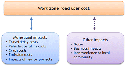
Within the context of this document, WZ RUC primarily refers to the monetized components of work zone impacts, such as the user delay costs, vehicle operating costs (VOC), crash costs and emission costs. Increasingly, other off-site components such as noise, business and local community impacts are being utilized in WZ RUC applications. These off-site impacts are hard to monetize since the factors that influence their computation are often site-specific and no generalized method or tool is yet available to determine them. In this document, these off-site impacts are either considered as quantitative /non-monetary (e.g. noise) or qualitative (e.g. inconvenience to local community) factors. The components of WZ RUC are illustrated in Figure 1 and discussed in greater detail in the sections that follow. The practitioners can use their discretion in selecting appropriate work zone impacts to be used in WZ RUC analysis.
Figure 1. Road user cost components.
The WZ RUC computation process is based on the assessment of mobility, safety, environmental, business, and local community impacts resulting from the work zone activities of a roadway project. The WZ RUC computation along with the work zone impacts assessment evolves through various stages of the project development process from planning through construction. The precision of WZ RUC estimate and, the type and level of detail of impacts assessment vary depending upon the project development stage. (Sankar, P., K. Jeannotte, J. P. Arch, M. Romero, and J. E. Bryden, Work Zone Impacts Assessment – An Approach to Assess and Manage Work Zone Safety and Mobility Impacts of Road Projects, Report No. FHWA-HOP-05-068, Office of Operations, Federal Highway Administration, Washington, DC, 2006.) For example, in the project scoping stage, a conceptual estimation or qualitative information of WZ RUC may be used in identifying the significance of potential impacts; and during preliminary engineering a rough estimation of WZ RUC will be determined for use in MOT strategy selection; whereas, in the 90 percent design stage, a precise estimate will be determined for use in setting the contract provisions such as lane rental fee and incentives/disincentives.
The WZ RUC computation process involves the following key steps:
- Data gathering for work zone impact assessment.
- Estimation of work zone impacts.
- Computation of unit costs for each impact type.
- Estimation of WZ RUC components.
This chapter presents a detailed discussion of the key concepts of quantifiable monetary impacts. The process involved in deriving the monetary components and their unit costs is illustrated using step-by-step procedures. A less-rigorous discussion of non-monetary and qualitative factors is also presented. Later sections of this chapter focus on data requirements for mobility analysis and computation tools available for WZ RUC estimation.
2.2 Travel Delay Costs
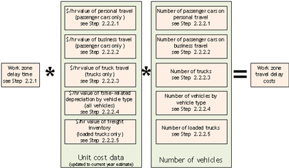
Travel delay costs are calculated by multiplying the estimated delays to personal travel, truck travel, and freight inventory caused by the work zone by the unit cost ($/hr) of travel time. Figure 2 presents the computation of travel delay costs schematically.
2.2.1 Delay Time
Delay time is the additional travel time necessary to traverse the work zone or to detour around it. Delay time is an aggregation of the following components:
- Speed change delay is the additional time necessary to decelerate from the upstream approach speed to the work zone speed and then to accelerate back to the initial approach speed after traversing the work zone under unrestricted (free) traffic flow.
- Reduced speed delay is the additional time necessary to traverse the work zone at the lower posted speed; it depends on the upstream and work zone speed differential and length of the work zone under both unrestricted and restricted (forced) traffic flow.
- Detour delay is the additional time necessary to travel the excess distance by selecting a detour route.
Figure 2. Schematic illustrating the components of travel delay costs.
- Stopping delay is the additional time necessary to come to a complete stop from the upstream approach speed (instead of just slowing to the work zone speed) and the additional time to accelerate back to the approach speed after traversing the work zone under restricted traffic flow.
- Queue delay is the additional time necessary to creep through the queue under restricted traffic flow.
Note: Some highway agencies do not consider speed change delay and stopping delay in delay time computations, as these components may not contribute significantly to the overall delay time. To those interested in including these components, the FHWA RealCost (RealCost, Life-Cycle Cost Analysis Software, Version 2.5, Office of Asset Management, Federal Highway Administration, Washington, DC, 2009.) software provides a methodology for computing them.
Work zone traffic delay time estimates can be obtained using mobility impact analysis methods such as demand-capacity analysis and simulation methods. The inputs required for mobility analysis are discussed in section 2.8. A discussion of various tools readily available for delay time estimation and WZ RUC computation is presented in section 2.9. Note that the estimated mobility parameters may change based on the selected tool, as the methodologies utilized in these tools may be different. Delay time during construction also can be estimated using the floating-car technique, where a test car is driven by an observer along the work zone section a number of times to measure the travel time.
Note: The precision of mobility related performance measures, such as the travel delay time and queue length, may vary with the type of traffic analysis tool selected for the work zone impact analysis. Microscopic simulation tools generally provide more precise estimates than spreadsheet-based tools.
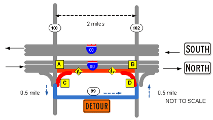
Example 2.0: Description of a hypothetical work zone used in illustrative examples
A hypothetical example is presented herein to illustrate the computation of travel delay and vehicle operating costs. The information presented in this example is intended for illustrative purposes only.
One northbound lane of a six-lane, urban facility, Interstate 00, is undergoing bituminous pavement rehabilitation. The northbound lanes carry an average daily traffic of 33,000 vehicles of which 8 percent are single-unit trucks and 4 percent are combination trucks. A 2.0-mile work zone (marked in red) with a 24-hour/day, single lane closure will be in effect between point A and point B until the construction is complete. The unrestricted upstream approach speed is posted at 55 mph, and the work zone speed is posted at 45 mph. The estimated duration to complete pavement rehabilitation is 20 days.
The entry ramp connecting Hwy 100 and I-00 northbound lanes is closed; a 3-mile detour on Route 99 through Hwy 102 is in effect for the ramp traffic. Similarly, the exit ramp connecting I-00 northbound lanes and Hwy 102 is closed. The ramp traffic is expected to take a detour through Hwy 100 exit ramp and Route 99. The blue arrow in the figure below indicates the travel direction for the designated detour. The traffic volume on both exit and entry ramps is 1,000 vehicles a day, of which 3 percent are single-unit trucks and 2 percent are combination trucks. The average speed through the detour is 40 mph.
Example 2.1: Understanding the components of work zone travel delay time
For the hypothetical work zone scenario presented in Example 2.0, the computation of travel delay time involves the following computation:
- Speed change delay - the expected time the vehicles take to decelerate from the upstream speed of 55 mph to the work zone speed of 45 mph when approaching point A and the time to accelerate from 45 mph to 55 mph after crossing point B.
- Stopping delay - the expected time the vehicles take to decelerate from the upstream speed of 55 mph to a complete stop (0 mph) under restricted flow or queuing conditions, and the time to accelerate to 55 mph.
- Reduced speed delay - the expected additional time the vehicles take to cross the 2-mile segment at 45 mph compared to the time to cross the segment at 55 mph.
- Queue delay - the expected time the vehicles take to cross the 2-mile work zone under restricted flow or queuing conditions.
- Detour delay - the expected additional time the vehicles take from a northbound lane to reach Hwy 102 by traveling through the I-00to Hwy 100 exit ramp and Route 99. It also applies to the vehicles taking Route 99 and Hwy 102 to I-00 entry ramp to merge into I-00 through traffic.
Example 2.2: Computation of work zone travel delay time
A work zone travel delay analysis was performed for the mainline I-00 traffic. The various components of travel delays computed using the FHWA’s RealCost program are summarized in the following table:
| Time (RealCost does not report the output results as presented in this table. The results obtained from the RealCost worksheets were modified for illustration purposes. |
Volume | WZ Capacity | Queued Vehicles | Speed Change Delay (Delay times were reported as average delay time per vehicle in minutes.) |
Reduced Speed Delay (Delay times were reported as average delay time per vehicle in minutes.) |
Stopping Delay (Delay times were reported as average delay time per vehicle in minutes.) |
Queuing Delay
(Delay times were reported as average delay time per vehicle in minutes.) |
Flow Condition |
|---|---|---|---|---|---|---|---|---|
| 00-01 | 304 | 2554 | 0 | 0.07 | 0.24 | 0 | 0 | No queue (unrestricted flow) |
| 01-02 | 304 | 2554 | 0 | 0.07 | 0.24 | 0 | 0 | No queue (unrestricted flow) |
| 02-03 | 304 | 2554 | 0 | 0.07 | 0.24 | 0 | 0 | No queue (unrestricted flow) |
| 03-04 | 456 | 2554 | 0 | 0.07 | 0.24 | 0 | 0 | No queue (unrestricted flow) |
| 04-05 | 646 | 2554 | 0 | 0.07 | 0.24 | 0 | 0 | No queue (unrestricted flow) |
| 05-06 | 988 | 2554 | 0 | 0.07 | 0.24 | 0 | 0 | No queue (unrestricted flow) |
| 06-07 | 1558 | 2554 | 0 | 0.07 | 0.24 | 0 | 0 | No queue (unrestricted flow) |
| 07-08 | 2964 | 2554 | 410 | 0.40 | 0.24 | 0.40 | 23.81 | Queue (restricted flow) |
| 08-09 | 3610 | 2554 | 1466 | 0.40 | 0.24 | 0.40 | 23.81 | Queue (restricted flow) |
| 09-10 | 2470 | 2554 | 1382 | 0.40 | 0.24 | 0.40 | 23.81 | Queue (restricted flow) |
| 10-11 | 1786 | 2554 | 614 | 0.40 | 0.24 | 0.40 | 23.81 | Queue (restricted flow) |
| 11-12 | 1710 | 2554 | 0 | 0.47 | 0.24 | 0.40 | 23.81 | Queue (restricted flow) |
| 12-13 | 1634 | 2554 | 0 | 0.07 | 0.24 | 0 | 0 | No queue |
| 13-14 | 1710 | 2554 | 0 | 0.07 | 0.24 | 0 | 0 | No queue |
| 14-15 | 1862 | 2554 | 0 | 0.07 | 0.24 | 0 | 0 | No queue |
| 15-16 | 2470 | 2554 | 0 | 0.07 | 0.24 | 0 | 0 | No queue |
| 16-17 | 3002 | 2554 | 448 | 0.40 | 0.24 | 0.40 | 23.81 | Queue |
| 17-18 | 3534 | 2554 | 1428 | 0.40 | 0.24 | 0.40 | 23.81 | Queue |
| 18-19 | 2432 | 2554 | 1306 | 0.40 | 0.24 | 0.40 | 23.81 | Queue |
| 19-20 | 1482 | 2554 | 234 | 0.40 | 0.24 | 0.40 | 23.81 | Queue |
| 20-21 | 1254 | 2554 | 0 | 0.47 | 0.24 | 0.40 | 23.81 | Queue |
| 21-22 | 684 | 2554 | 0 | 0.07 | 0.24 | 0 | 0 | No queue |
| 22-23 | 456 | 2554 | 0 | 0.07 | 0.24 | 0 | 0 | No queue |
| 23-24 | 380 | 2554 | 0 | 0.07 | 0.24 | 0 | 0 | No queue |
This table presents the work zone lane capacity and 24-hour cycle of hourly traffic demand on the northbound lanes. Two of the three available lanes are open in the northbound direction. When the hourly volume is less than the capacity, unrestricted flow exists, and as expected, no queue is formed. Only the delay time components due to speed change and reduced speed are calculated. However, when the hourly volume exceeds the capacity, the traffic flow is restricted, and a queue is formed. The restricted flow condition remains until the queue is cleared fully.
Detour delay time = (detour length/detour speed)- (normal travel length/upstream speed)
Detour delay time = (3.0 mile/40 mph) – (2.0 mile/55 mph) = 2.32 min/vehicle
The various components of work zone travel delay are combined to compute the total delay time, as illustrated in the following table:
| Time | Mainline Traffic Volume | Total Delay Time (minutes/vehicle) | Delay Time for all Vehicles (veh-hours/day) | ||||
|---|---|---|---|---|---|---|---|
| Speed Change | Reduced Speed | Stopping | Queuing | Total | |||
| 00-01 | 304 | 0.07 | 0.24 | 0 | 0 | 0.32 | 1.60 |
| 01-02 | 304 | 0.07 | 0.24 | 0 | 0 | 0.32 | 1.60 |
| 02-03 | 304 | 0.07 | 0.24 | 0 | 0 | 0.32 | 1.60 |
| 03-04 | 456 | 0.07 | 0.24 | 0 | 0 | 0.32 | 2.41 |
| 04-05 | 646 | 0.07 | 0.24 | 0 | 0 | 0.32 | 3.41 |
| 05-06 | 988 | 0.07 | 0.24 | 0 | 0 | 0.32 | 5.22 |
| 06-07 | 1558 | 0.07 | 0.24 | 0 | 0 | 0.32 | 8.22 |
| 07-08 | 2964 | 0.40 | 0.24 | 0.40 | 23.81 | 24.85 | 1227.34 |
| 08-09 | 3610 | 0.40 | 0.24 | 0.40 | 23.81 | 24.85 | 1494.84 |
| 09-10 | 2470 | 0.40 | 0.24 | 0.40 | 23.81 | 24.85 | 1022.79 |
| 10-11 | 1786 | 0.40 | 0.24 | 0.40 | 23.81 | 24.85 | 739.55 |
| 11-12 | 1710 | 0.47 | 0.24 | 0.40 | 23.81 | 24.92 | 710.20 |
| 12-13 | 1634 | 0.07 | 0.24 | 0 | 0 | 0.32 | 8.62 |
| 13-14 | 1710 | 0.07 | 0.24 | 0 | 0 | 0.32 | 9.03 |
| 14-15 | 1862 | 0.07 | 0.24 | 0 | 0 | 0.32 | 9.83 |
| 15-16 | 2470 | 0.07 | 0.24 | 0 | 0 | 0.32 | 13.04 |
| 16-17 | 3002 | 0.40 | 0.24 | 0.40 | 23.81 | 24.85 | 1243.08 |
| 17-18 | 3534 | 0.40 | 0.24 | 0.40 | 23.81 | 24.85 | 1463.37 |
| 18-19 | 2432 | 0.40 | 0.24 | 0.40 | 23.81 | 24.85 | 1007.05 |
| 19-20 | 1482 | 0.40 | 0.24 | 0.40 | 23.81 | 24.85 | 613.67 |
| 20-21 | 1254 | 0.47 | 0.24 | 0.40 | 23.81 | 24.92 | 520.81 |
| 21-22 | 684 | 0.07 | 0.24 | 0 | 0 | 0.32 | 3.61 |
| 22-23 | 456 | 0.07 | 0.24 | 0 | 0 | 0.32 | 2.41 |
| 23-24 | 380 | 0.07 | 0.24 | 0 | 0 | 0.32 | 2.01 |
| Total delay time of mainline through traffic | =10,115.32 | ||||||
| Detour delay time = 2.32 min/vehicle * 2000 vehicles= 4636 min | = 77.28 | ||||||
| Total estimated delay time per day | 10,192.6 | ||||||
The delay time for all vehicles traveling through the I-00 work zone = 10,192.6 vehicle-hours per day.
The average delay time for a vehicle traveling through the I-00 work zone = 10,192.6/33,000 = 0.309 hr/veh/day.
Note: Traditionally the work zone mobility impacts are evaluated in terms of simple averages of travel time delays. As the travel times of road users vary greatly from day to day, the use of average delay time values does not reflect the "real world" experience of road users.
Increasingly, the concept of "travel time reliability" is rapidly gaining importance in travel congestion studies. This measure takes the difference between the actual and the expected travel time into account. The commonly used travel time reliability metrics include the Buffer Time Index, 95th percentile of travel times, Travel Time Index percent “on-time performance”, and travel time window.
2.2.2 Monetary Value of Travel Time
Like goods and services, time spent traveling in a vehicle is a resource with economic value. The monetary value of travel time is based on the concept that time spent traveling otherwise would have been spent productively, whether for remunerative work or recreation. The United States Department of Transportation (USDOT) Office of the Secretary of Transportation (OST) provides guidelines and procedures for calculating the value of travel time saved or lost by road users. (USDOT, Valuation of Travel Time in Economic Analysis-Revised Departmental Guidance, Memorandum, Office of the Secretary of Transportation, U.S. Department of Transportation, Washington, DC. 2003.) (The value of travel time can be established using the wage rate method or road users’ stated/revealed preference. The OST guidance is based on the wage rate method. Under the stated/revealed preference method, the information on road users’ alternative choice of route or travel mode is gathered through surveys or polling. Based on the collected information, the associated travel time and cost differentials between the baseline and the preferred alternative choices are used in establishing the value of travel time through statistical modeling.)
Monetary value of travel time is a sum of:
- Dollar value of personal travel time (only passenger cars).
- Dollar value of business travel time (only passenger cars).
- Value of truck travel time (only trucks).
- Cost of freight inventory delay (only trucks).
- Cost of vehicle depreciation (all vehicles).
Note that the available unit cost data used in the computation of these monetary components may not reflect current or most recent year statistics. Practitioners are advised to adjust the existing year data to current year data using appropriate adjustment factors mentioned herein. In addition, the highway agencies can use their discretion in combining or eliminating smaller cost components as deemed appropriate.
2.2.2.1 Monetary Value of Personal Travel Time
The hourly dollar value of road users’ personal travel time is estimated based on some percentage of their wages. The steps involved in monetizing the personal travel delay time are enumerated as follows.
Step 1. Determine the proportion of passenger cars on personal travel. This proportion may vary with the type of travel: local or intercity. The number of person miles reported in the National Household Transportation Survey (NHTS) is used in determining the proportion of passenger cars on personal travel. Travel patterns reported in the NHTS and the Nationwide Personal Transportation Survey (NPTS) over the past 20 years are summarized in Table 1.
| Study | Travel Type | Personal | Business |
|---|---|---|---|
| 1990 NPTS (Hu, P. S. and J. Young, 1990 Nationwide Personal Transportation Survey (NPTS) Databook, Report No. FHWA-PL-94-010A, Prepared by Oak Ridge National Laboratory, Submitted to the Office of Highway Information Management, Federal Highway Administration, Washington, DC, November 1993.) | Local (Reported in 1990 NPTS Databook, Vol. I, Table 4.41, page 4-72.) | 95.8% | 4.2% |
| Intercity (Reported in 1990 NPTS Databook, Vol. II, Table 8.13, page 8-22.) | 95.0% | 5.0% | |
| 1995 NPTS (Oak Ridge National Laboratory, 1995 Nationwide Personal Transportation Survey (NPTS) Databook, Report No. ORNL/TM-2001/248, Prepared for FHWA Office of Highway Information Management, Oak Ridge National Laboratory, Oak Ridge, TN, October, 2001.) | Not Specified | 94.2% | 5.8% |
| 2001 NHTS (Hu, P. S. and T. R. Reuscher, Summary of Travel Trends, 2001 National Household Travel Survey, Prepared by Oak Ridge National Laboratory, Submitted to the Federal Highway Administration, Washington, DC, November 2004.) | Not Specified | 91.9% | 8.1% |
| 2009 NHTS (Obtained from NHTS Online Analysis Tools - Table Designer using the variables: 1990 Trip Purpose and the annual person miles of travel (for Step 4)/ average vehicle occupancy (for Step 5).) | Not Specified | 93.7% | 6.3% |
Note: This report uses the national travel behavior statistics obtained from the NHTS sampling data. To reflect local trends, agencies are encouraged to use location-specific or region-specific statistics obtained from their travel behavior survey programs using the same methodology described herein.
Step 2. Establish the average vehicle occupancy (AVO) of passenger cars. The AVO is the ratio of person-miles of travel and vehicle-miles of travel by trip type. (Obtained from NHTS Online Analysis Tools - Table Designer using the variables: 1990 Trip Purpose and the annual person miles of travel (for Step 4)/ average vehicle occupancy (for Step 5).) Refer to Table 2 for the recent NHTS estimates of AVO values. The average AVO for personal travel was 1.67 in 2009. The AVO of intercity personal travel is higher than that of local personal travel. Estimates of 1990 NPTS (Vol. 2, Table 8.15, of the NPTS report) indicate that the AVO factor for intercity travel was 2.30, whereas the AVO for local travel was 1.66. By selecting an appropriate AVO, the delay time can be converted from person-hours to vehicle-hours or vice-versa.
Source: NHTS Online Analysis Tools
Step 3. Estimate per hour monetary value of travel time for a person on personal travel. The dollar value of personal travel time (per person –hr) is estimated using the median annual income for all U.S. households reported by the U.S. Census Bureau, in accordance with the OST guidelines (see Table 3). (Median Household Income reported by US Census Bureau.)
Hourly value of personal travel time per person is calculated as:
For local personal travel,
Hourly value of personal travel time per person = 50% of median annual household income ÷ 2080 hours.
Median annual income for all U.S. households = $49,445 (for 2010). (DeNavas-Walt, C., B. D. Proctor, J. C. Smith, Income, Poverty, and Health Insurance Coverage in the United States: 2010, Report No. P60-239, US Census Bureau, September 2011.)
Hourly value of personal travel time = 0.5* $49,445/2080 = $11.89/person -hr
For intercity personal travel,
Hourly value of personal travel time per person = 70% of median annual household income ÷ 2080 hours.
Median annual income for all U.S. households = $49,445 (for 2010)
Hourly value of personal travel time = 0.7* $49,445 /2080 = $16.64/person –hr
Step 4. Compute per hour monetary value of travel time for a vehicle on personal travel. The dollar value of personal travel time for all occupants in a vehicle, in terms of dollar/vehicle-hr, is computed by multiplying the dollar value of hourly travel time per person with an appropriate AVO factor. In other words, the hourly travel time per person is converted to hourly travel time per vehicle to estimate delay time costs based on the number of vehicles (instead of the number of persons) traveling on the roadway.
For local personal travel,
Hourly value of a person’s travel time in a vehicle= $11.89/person -hr
Average vehicle occupancy = 1.67 persons per vehicle
Hourly travel time value of all occupants in a vehicle or the hourly value of a vehicle on personal travel = $11.89 * 1.67 = $19.85/vehicle-hr
The hourly travel time value of a vehicle on personal travel is same as the vehicle’s delay time costs.
For intercity personal travel,
Hourly value of travel time = $16.75/person -hr
Average vehicle occupancy = 2.30 persons per vehicle
Hourly value of vehicle delay time = $16.64 * 2.30 = $38.27/vehicle-hr
Step 5. Compute travel delay costs for passenger cars on personal travel. Multiply the hourly dollar value of vehicle delay time with the delay time of passenger cars on personal travel. For local or personal travel,
Total delay time for passenger cars on personal travel = Average delay time* Number of passenger car vehicles on personal travel (and)
Travel delay costs for passenger cars on personal travel = Total delay time for passenger cars on personal travel * hourly $ value of vehicle delay time
Note: Travel delay time for buses are computed by multiplying the average number of passengers in a bus with the unit cost ($/hr) of personal travel time of a passenger.
2.2.2.2 Monetary Value of Business Travel Time
The hourly dollar value of road users’ business travel time is estimated based on the employer’s costs of employees that include both wages and benefits. The steps involved in calculating the cost component of the business travel time are enumerated as follows:
Step 1. Determine the proportion of passenger cars on business travel. The number of person miles reported in the NHTS is used in determining the proportion of passenger cars on business travel (see Table 1).
Step 2. Establish the AVO of passenger cars. As shown in Table 2, the average AVO for business travel was 1.24 in 2009. Alternatively, agency-specific travel behavior statistics can be used to reflect local trends.
Step 3. Estimate per hour monetary value of travel time for a person on business travel. Hourly dollar value of a person’s time on business travel is estimated using the OST guidelines presented in Table 4. Total hourly wages and benefits of all civilian workers reported in the Bureau of Labor Statistics (BLS) Employer Costs for Employee Compensation (ECEC) are used. For current year estimates, the ECEC data released every quarter can be used for computations, or adjustments can be made using the BLS Employment Cost Index (ECI) data.
For both local and intercity business travel,
Hourly value of a person’s time on business travel = 100% of median hourly wages plus benefits.
Hourly employment cost = $29.75 (December, 2010)
Hourly value of a person’s time on business travel = $29.75/person –hr.
Step 4. Compute per hour monetary value of travel time for a vehicle on business travel. Multiply the hourly value of a person’s time on business travel with the AVO factor. Note that the AVO is assumed to be the same for passenger cars on business travel for both local and intercity travel.
Hourly value of a person’s time on business travel = $29.75/person -hr
Average vehicle occupancy = 1.24 persons per vehicle
Hourly time value of a vehicle on business travel = $29.75 * 1.24 = $36.89/veh-hr
Step 5. Compute travel delay costs for passenger cars on business travel. Multiply the hourly dollar value of vehicle delay time with the delay time of passenger cars on business travel.
For business travel,
Total delay time for passenger cars on business travel = Average delay time* Number of passenger car vehicles on business travel (and)
Travel delay costs for passenger cars on business travel = Total delay time for passenger cars on business travel * hourly $ value of vehicle delay time
Example 2.3: Computing travel delay costs for passenger cars
The computation of travel delay costs for passenger cars for the I-00 work zone scenario involves computing the hourly dollar value of travel delay time for passenger cars on both personal and business travel, then multiplying their weighted average with the estimated delay time of all passenger cars. Assume that the median annual household income for the area, where the I-00 work zone is located, is $52,000.
Step 1. Estimate the unit value of personal travel time for passenger cars
Median annual household income of the area = $52,000
Hourly time value of a person on personal travel = 50% of $52,000÷2080 hrs
Hourly time value of a person on personal travel = $12.5/person-hr
Average vehicle occupancy for personal travel = 1.67 persons per vehicle
Hourly time value of a vehicle on personal travel = 1.67 * 12.5 = $20.88/vehicle-hr
Step 2. Estimate the unit value of business travel time
Estimate the sum of hourly wages and benefits from the ECEC statistics available on the BLS website.
Hourly employment cost for the quarter December 2010= $29.75
Hourly time value of a person on business travel = $29.75/person-hr
Average vehicle occupancy = 1.24 persons per vehicle
Hourly time value of vehicle on business travel = $29.75 * 1.24 = $36.89/vehicle-hr
Step 3. Compute the weighted average of travel time values for passenger cars considering both personal and business travel
Per 2009 NHTS statistics, 93.7% and 6.3% of passenger cars are expected on personal and business travel, respectively. Therefore,
Hourly time value of a vehicle on personal travel = $20.88/vehicle-hr
Hourly time value of vehicle on business travel = $36.89/vehicle-hr
Weighted average of hourly time value of passenger cars= 93.7% of $20.88 + 6.3% of $36.89 = $21.89/hr
Hourly time value of passenger cars = $21.89/hr
Step 4. Estimate the delay costs for passenger cars on the northbound lanes
Percent of passenger cars = 88% (from Example 2.0)
Estimated delay time for all vehicles = 10,192.6 vehicle-hours/day (from Example 2.2)
Estimated delay time for passenger cars = 0.88* 10,192.6 = 8969.49 vehicle-hours/day
Estimated delay costs for passenger cars = 8969.49 * $21.89 /hr = $196,342.10 /day
2.2.2.3 Monetary Value of Truck Travel Time
Hourly dollar value of truck travel time is estimated based on the compensation costs of truck drivers that include both wages and benefits. The steps involved in calculating the cost component of the truck travel time are enumerated as follows:
Step 1. Determine the average vehicle occupancy of trucks. NHTS data provide AVO values only for cars and light-duty trucks. There are no national averages or sources for AVO values of trucks. Agencies can use region-specific data, if available. In the absence of national or region-specific values, the truck AVOs recommended in the Highway Economic Requirement System (HERS)-ST Technical Report can be utilized. (FHWA, Highway Economic Requirements System-State Version, Technical Report, Federal Highway Administration, Washington, DC, 2005.) HERS-ST recommends an AVO of 1.025 for a single-unit truck (i.e., 1.05 for single-unit, six-tire trucks and 1.0 for heavier single-unit trucks) and 1.12 for combination trucks. The weighted average of AVOs of different truck types can be used.
Step 2. Determine the average wages and benefits for truck drivers. Per the BLS National Occupational Employment and Wage Estimates published in May 2009, the median hourly wages for truck drivers are presented as follows (Occupational Employment Statistics, Published by Bureau of Labor Statistics, US Department of Labor.):
Truck Drivers, Heavy and Tractor-Trailer = $18.87/hr (May 2009)
Truck Drivers, Light or Delivery Services (capacity of under 26,000 lb gross vehicle weight [GVW])
= $14.90/hr (May 2009)
Truck Drivers (both light and heavy) = $16.89/hr (May 2009)
Per the BLS ECEC data, the average benefit for employees in transportation and material moving jobs is $7.60/hr (for June 2009). Note that the wage rates and benefits can be adjusted to the current year using the current release of the BLS ECI or the Occupational Employment Statistics. State or local estimates of wages and benefits can be substituted for national estimates.
The following computation shows how to adjust the existing hourly compensation data to the current year data:
Wages & benefits of truck drives (both light and heavy) = $16.89/hr (May 2009)
Employment Cost Index (June 2009) (Historical ECI data can be obtained from ECT databases on the BLS website. Total compensation, all civilian, index numbers and all workers were used in determining the ECI value.) = 110.3
Employment Cost Index (Dec 2010) = 113.3
Wages & benefits adjusted for Dec 2010 = $16.89 * 113.3/110.3 = $ 17.35 /hr
Step 3. Estimate per hour monetary value of truck travel time. Determine the hourly dollar value of truck travel time by multiplying the hourly compensation (sum of wages and benefits) of truck drivers with the AVO factor.
Single-unit trucks = 1.025 * ($14.90 + $7.60) = $23.06/hr (May 2009)
Combination-unit trucks = 1.12 * ($18.87 + $7.60) = $29.65/hr (May 2009)
Step 4. Compute delay costs for truck travel. To determine the delay cost component of truck travel, multiply the hourly dollar value with travel delay time of trucks, either by truck type (single-unit or combination trucks) or the total number of trucks.
Example 2.4: Computing travel delay costs for trucks
For the I-00 work zone scenario, the travel delay costs for trucks are computed by multiplying the estimated delay time for trucks by the hourly compensation (including wages and benefits) of truck drivers. If the hourly compensation rates are calculated separately for single-unit and combination trucks, the delay costs can be computed separately using appropriate hourly compensation values and summed later.
Step 1. Estimate the unit value of truck travel time
Average compensation of drivers of single-unit trucks = $22.50/person-hr
Average vehicle occupancy of single-unit trucks = 1.025
Hourly time value of single-unit trucks = 1.025 * $22.50 = $23.06/hr
Average compensation of drivers of combination trucks = $26.47/person-hr
Average vehicle occupancy of combination trucks = 1.12
Hourly time value of combination trucks = 1.12 * $26.47 = $29.65/hr
Step 2. Estimate the delay costs for both single-unit and combination trucks on the northbound lanes
Percent of single-unit trucks = 8% (from Example 2.0)
Estimated delay time for all vehicles = 10,192.6 vehicle-hours/day (from Example 2.2)
Estimated delay time for single-unit trucks = 0.08* 10,192.6 = 815.41 vehicle-hours/day
Estimated delay costs for single-unit trucks = 815.41 * $23.06/hr = $18,803.31/day
Percent of combination trucks = 4% (from Example 2.0)
Estimated delay time for combination trucks = 0.04* 10,192.6 = 407.7 vehicle-hours/day
Estimated delay costs for combination trucks = 407.7 * $29.65/hr = $12,088.42/day
Estimated delay costs for all trucks = $18,803.31+ 12,088.42 = $30,891.73
2.2.2.4 Cost of Time-Related Vehicle Depreciation
Vehicles depreciate as a function of aging and usage over time. Total vehicle depreciation costs are estimated from the average annual ownership costs of vehicles, while mileage-related vehicle depreciation costs are estimated using the VOC procedure discussed in section 2.3. Time-related vehicle depreciation costs typically are estimated by subtracting mileage-related depreciation from total depreciation. Time-related vehicle depreciation costs incurred by vehicle owners due to work zone delay are estimated herein using the methodology outlined in the HERS-ST Technical Report. The steps involved in computing the time-related vehicle depreciation costs are as follows:
Step 1. Determine the HERS-ST estimates of hourly cost of time-related vehicle depreciation for each vehicle type in 1995 dollars. Table 5 presents the HERS-ST estimates of hourly cost of total, mileage-related, and time-related vehicle depreciation (in 1995 dollars) for various vehicle types.
Step 2. Adjust the depreciation costs from 1995 dollars to current year dollars. To adjust 1995 dollars to current year dollars, the use of the Producer Price Index (PPI)—Commodity data for transportation equipment (Item 14) is recommended. (Producer Price Indexes, Published by Bureau of Labor Statistics, US Department of Labor (the use of multi-screen search tool is suggested.) As the time-related depreciation largely depends on the initial price of the vehicles, the use of the PPI for cost adjustment is deemed appropriate. However, this adjustment may not consider the change in vehicle registration, licensing and permit taxes, insurance premiums, and financing costs over time. Table 6 presents the hourly costs of time-related vehicle depreciation adjusted to 2010 values.
Source: HERS-ST Technical Manual (2005) (FHWA, Highway Economic Requirements System-State Version, Technical Report, Federal Highway Administration, Washington, DC, 2005.)
In addition to the depreciation values provided by the HERS-ST, practitioners also can use the following resources:
- American Automobile Association (AAA) (American Automobile Association, Your Driving Costs.)
- American Transportation Research Institute (ATRI) (Trego, T., and D. Murray (2010))
Note: The relationship between the vehicle types provided in Tables 5 and 6 and the FHWA Traffic Monitoring Guide (TMG) vehicle classification scheme is presented in section 2.8.2. Depending on the vehicle classification data available, the average depreciation costs of various vehicle types can be computed as appropriate.
Step 3. Compute the hourly costs of time-related vehicle depreciation. Total depreciation cost is computed for each vehicle type by multiplying the hourly depreciation costs with the vehicle delay time.
Example 2.5: Computing time-related vehicle depreciation costs
For the I-00 work zone scenario, the time-related vehicle classification costs are calculated by multiplying the total delay time with the hourly time-related depreciation costs presented in Table 6.
Step 1. Estimate the hourly time-related depreciation costs for vehicle types
Since there are no vehicle class data (categorized using the FHWA TMG classification scheme), it is assumed that simple averages of hourly cost data (presented in Table 6) would represent the traffic composition on the I-00 project.
Hourly depreciation cost for passenger cars = simple average of hourly costs of small, medium sized, and large autos = (1.05 + 1.40)/2 = $1.225/hr
Hourly depreciation cost for single-unit trucks = simple average of hourly costs of four-tire and six-tire single-unit trucks = (2.58 + 3.60)/2 = $3.09/hr
Hourly depreciation cost for combination trucks = simple average of hourly costs of 3 or 4 axles, 3+ axle and 5+ axles combination trucks = (10.12 + 9.06 + 8.70)/3 = $9.29/hr
Step 2. Estimate the time-related depreciation cost for passenger cars, single-unit trucks, and combination trucks on the northbound lanes
Estimated delay time for all vehicles = 10,192.6 vehicle-hours/day (from Example 2.2)
Percent of passenger cars = 88% (from Example 2.0)
Estimated delay time for passenger cars = 0.88* 10,192.6 = 8969.49 vehicle-hours/day
Estimated time-related depreciation costs for passenger cars = 8969.49 * $1.225/hr = $10,987.62/day
Percent of single-unit trucks = 8% (from Example 2.0)
Estimated delay time for single-unit trucks = = 0.08* 10,192.6 = 815.4 vehicle-hours/day
Estimated time-related depreciation costs for single-unit trucks = 815.4 * $3.09/hr = $2,519.59/day
Percent of combination trucks = 4% (from Example 2.0)
Estimated delay time for combination trucks = 0.04* 10,192.6 = 407.7 vehicle-hours/day
Estimated time-related depreciation costs for combination trucks = 407.7 * $9.29/hr = $3,787.53/day
Estimated time-related depreciation costs for all vehicles = $10,987.62 + 2,519.59 + 3,787.53 = $17,294.74/day
2.2.2.5 Cost of Freight Inventory Delay
Hourly dollar value of freight inventory delay is estimated using the procedure described in the HERS-ST Technical Report. The inventory cost is computed by multiplying the average payload of the truck with the average value of commodities shipped by truck. HERS-ST recommends the calculation of inventory delay costs only for combination trucks; however, this report provides the calculation steps for both single-unit and combination trucks:
Step 1. Determine the number of loaded (partially or fully) freight trucks by FHWA vehicle class or vehicle type and their average pay loads. This information can be obtained from weigh-in-motion (WIM) data representative of the project. In the absence of such data, follow the discussion presented in Steps 2 and 3. Otherwise, skip to Step 4.
Step 2. Estimate the number of empty and loaded trucks. The number of loaded freight trucks can be obtained from subtracting the empty trucks from the total trucks. Note that the truck composition may also consist of empty trucks (otherwise called backhaul trucks) returning from the original destination point to the point of origin. The number of loaded trucks can be estimated from the national averages of percent empty trucks presented in Table 7.
Source: Alam, M., E. Fekpe, and M. Majed, FAF2 Freight Traffic Analysis, Submitted to FHWA Office of Freight Management and Operations, 2007. (Refer to Table 4)
Step 3. Estimate the average payload of trucks. Use the national averages presented in Table 8 to estimate average truck payload. These averages were obtained from an FAFP2P study that utilized the U.S. Census Bureau’s Vehicle Inventory and Use Survey (VIUS) database in the freight analysis. Practitioners may also use the State-specific payload data presented in Table 9 or local data.
Step 4. Determine the hourly discount rate. Hourly discount rate is the annual discount rate divided by the number of hours in a year (8,760 hours). The annual discount rate is the average prime bank lending rate plus 1 percent. The average prime bank lending rate for 2010 is 3.25 percent. (Prime bank lending rates for current can be obtained from the Statistics & Historical Data releases of the Federal Reserve.)
Hourly discount rate for 2010 = (3.25% +1%)/8760 = 0.000485%
Source: Alam, M., and G. Rajamanickam, Development of Truck Payload Equivalent Factor, Submitted to FHWA Office of Freight Management and Operations, 2007. (Refer to Table 3)
Source: Alam, M., and G. Rajamanickam, Development of Truck Payload Equivalent Factor, Submitted to FHWA Office of Freight Management and Operations, 2007. (Refer to Table 3)
Note: For less rigorous analysis, practitioners may use the average payload thee-axle truck (FHWA vehicle class 5) for single-unit trucks and five-axle truck/tractor trailers (FHWA vehicle class 9) for combination trucks. The average payloads of these two truck groups are reasonable for most traffic streams (except on major bus routes). It is reasonable to assume 25,000 lb and 42,000 lb as average payload values for single-unit and combination trucks, respectively.
Step 5. Determine the average value of commodities shipped by truck. The HERS-ST Technical Report cites that the average value of commodities shipped by truck (on a ton-mile weighted basis) was $1.35 per pound in 1993. ( The practitioners are recommended to periodically check with the FHWA Office of Freight Management and Operations for updated dollar value of commodities shipped by trucks.) Adjust this value to the current year using the Implicit Price Deflators for Gross Domestic Product-Goods. (Implicit Price Deflators for GDP can be obtained from Table 1.1.9 of the National Income and Product Account (NIPA) published by the Bureau of Economic Analysis.)
Average value of commodities shipped by truck = $1.35/lb (in year 1993)
Implicit Price Deflator for GDP-Goods = 93.786 (for year 1993)
Implicit Price Deflator for GDP-Goods = 105.405 (for year 2010)
Adjusted value of commodities shipped by truck in 2010 = $1.35 * (105.405/93.786) = $1.52/lb
Step 6. Determine the hourly value of freight shipped by truck. Multiply the current year value of commodities by the hourly discount rate.
Hourly value of freight inventory for 2010 = $1.52/lb * 0.000485%
Hourly value of freight inventory for 2010 = $7.37E-06/lb/hr
Step 7. Determine the hourly inventory cost for each truck. Multiply the hourly value of commodities ($/lb/hr) by the average payload of each truck type. The hourly inventory costs for the suggested payload values of single-unit trucks (25,000 lb) and combination trucks (42,000 lb) are $0.18 and $0.31 in 2010 dollars, respectively. Table 10 presents the hourly inventory costs for the average payload values presented in Table 8.
Step 8. Compute freight inventory delay costs. Multiply the number of loaded freight trucks (by truck type) by their hourly cost of freight inventory values.
Example 2.6: Computing the cost of freight inventory delay
For the I-00 work zone scenario, the cost of freight inventory delay is computed by multiplying the number of single-unit and combination trucks carrying freight by the hourly cost of freight inventory values.
Step 1. Estimate the hourly cost of freight inventory values
The hourly freight inventory costs suggested in Step 7 of section 2.2.2.5 are found reasonable for the I-00 Pavement Rehabilitation project.
Hourly freight inventory costs for single-unit trucks = $0.18/hr
Hourly freight inventory costs for combination trucks = $0.31/hr
Step 2. Estimate the number of loaded freight trucks
Estimated percent of empty single-unit trucks (from Table 7) = 29%
Estimated percent of empty combination trucks (from Table 7) = 27%
Annual average daily traffic = 33,000 (from Example 2.0)
Percent of single-unit trucks = 8% (from Example 2.0)
Total number of single-unit trucks = 0.08 * 33,000 = 2,640
Estimated number of empty single-unit trucks = 0.29*2,640 = 766
Estimated number of loaded single-unit trucks =2640 - 766 = 1,874
Percent of combination trucks = 4% (from Example 2.0)
Total number of combination trucks = 0.04 * 33,000 = 1,320
Estimated number of empty combination trucks =0.27*1320 = 356
Estimated number of loaded combination trucks =1,320 - 356 = 964
Step 3. Estimate the cost of freight inventory delay
Average delay time for a vehicle = 10,192.6/33,000 = 0.309 hr/veh/day (from Example 2.2)
Cost of freight inventory delay for single-unit trucks = hourly cost for average payload * number of single-unit trucks * average delay time = 0.18 * 1,874 * 0.309 = $104.23/day
Cost of freight inventory delay for combination trucks = hourly cost for average payload * number of combination trucks * average delay time = 0.31 * 964 * 0.309 = $92.34/day
Cost of freight inventory delay = $104.23 + 92.34 = $196.57/day
Example 2.7: Computing the total travel delay costs
For the I-00 work zone scenario, the total travel delay costs are computed by summing the component costs as shown below:
- Travel delay costs for passenger cars = $196,342.10/day (from Example 2.3)
- Travel delay costs for trucks = $30,891.73 (from Example 2.4)
- Time-related depreciation costs for all vehicles = $17,294.74/day (from Example 2.5)
- Cost of freight inventory delay = $196.57/day (from Example 2.6)
Total delay costs = $196,342.10 + 30,891.73 + 17,294.74 + 196.57 = $244,725.14/day
2.3 Vehicle Operating Costs
VOC are the expenses incurred by road users as a result of vehicle use. VOC are the running costs that vary with the degree of vehicle use, and are thus mileage dependent, and do not include fixed costs such as insurance, time-dependent depreciation, financing, and storage.
In WZ RUC analysis, VOC is an aggregation of the following components:
- Speed change VOC is the additional cost under unrestricted conditions associated with decelerating from the upstream approach speed to the work zone speed and then accelerating back to the approach speed after leaving the work zone.
- Stopping VOC is the additional cost under restricted conditions associated with stopping from the upstream approach speed and accelerating back up to the approach speed after traversing the work zone.
- Queue idling VOC is the additional cost associated with stop-and-go driving in the queue. The idling cost rate multiplied by the additional time spent in the queue is an approximation of actual VOC associated with stop-and-go conditions. When a queue exists, stopping delay and VOC replace the free-flow speed change delay and VOC.
- Detour VOC is the additional cost associated with the excess distance to be traveled by selecting a detour route under unrestricted or restricted conditions.
Example 2.8: Understanding the components of VOC
For the work zone scenario presented in Example 2.0, the computation of vehicle operating costs for the I-00 work zone scenario involves the following:
- Speed change VOC - the additional costs incurred for the vehicles to decelerate from the upstream speed of 55 mph to the work zone speed of 45 mph when approaching point A and the time to accelerate from 45 mph to 55 mph after crossing point B.
- Stopping VOC - the additional costs incurred for the vehicles to decelerate from the upstream speed of 55 mph to a complete stop (0 mph) under restricted flow or queuing conditions, and the time to accelerate to 55 mph.
- Queue idling VOC - the additional costs incurred for the vehicles idling in the queue under restricted flow conditions.
- Detour VOC - the additional costs incurred for the extra distance the vehicles have to travel through the I-00àHwy 100 exit ramp and Route 99 to reach Hwy 102 as opposed to taking I-00 to Hwy 100 exit ramp. It also applies to the vehicles taking Route 99 and Hwy 102 to I-00 entry ramp to merge into I-00 through traffic.
2.3.1 Estimating VOC
VOC includes the consumption costs of the following resources:
- Fuel consumption.
- Engine oil consumption.
- Tire-wear.
- Repair and maintenance.
- Mileage-related depreciation.
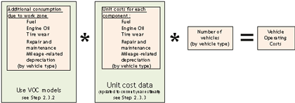
VOC is measured by quantifying the consumption of these resources while driving a vehicle between two points and multiplying those quantities with the corresponding unit cost of resources. Figure 3 presents the computation of VOC schematically.
Figure 3. Schematic illustrating the components of VOC.
The resource consumption is a function of prevailing roadway and traffic characteristics and can vary significantly with factors such as roadway geometry, traffic volume and composition, travel delay, and speed. Table 11 presents a matrix showing how each resource is influenced by various roadway factors.
Source: Lewis, D. L. Road User and Mitigation Costs in Highway Pavement Projects, NCHRP Synthesis 269, National Cooperative Highway Research Program, Transportation Research Board, Washington DC, 1996.
For WZ RUC analysis, the VOC is estimated for the traffic flowing through the work zone as well as those diverted through detour routes (if applicable). Traffic flowing through the work zone undergoes acceleration/deceleration cycles, stopping and idling depending on the flow condition (i.e. unrestricted or restricted). VOC models can be used to account for the effect of change in flow condition changes on resource consumption.
Traffic diverted through the detour routes may or may not experience change in flow conditions depending on the detour route capacity and diverted traffic volume. If there is forced flow condition, a detailed traffic analysis using VOC models is required for detour routes at the network or route level (depending on the impact and site-specific factors). Otherwise, a simple per-mile estimate can be used in VOC estimation for free flow conditions. VOC models provide per-mile estimates for constant-operating conditions with due consideration to travel speed, grade, and pavement conditions. Alternate cost sources such as AAA or ATRI can also be used for simpler, flat-rate per-mile estimates.
2.3.2 VOC Models
VOC models provide a detailed methodology for quantifying the additional resources consumed due to change in traffic flow conditions. Three methods are used commonly in the U.S. for determining VOC:
- National Cooperative Highway Research Program (NCHRP) Report 133 method. (Curry, D.A. and D.G. Anderson, Procedures for Estimating Highway User Costs, Air Pollution, and Noise Effects, National Cooperative Highway Research Program Report 133, Transportation Research Board, Washington, DC, 1972.)
- Texas Research and Development Foundation method. (Zaniewski, J. P., B. C. Butler, G. Cunningham, G. E. Elkins, M. S. Paggi, and R. Machemehl. Vehicle Operating Costs, Fuel Consumption and Pavement type and Condition Factors, Final
Report # DOT-FH-11-9678, Prepared by Texas Research and Development Foundation, Federal Highway Administration, Washington, DC, 1982.) - HERS-ST method.20
- U.S. Environmental Protection Agency (EPA)’s Motor Vehicle Emission Simulator (MOVES)—Only fuel consumption costs can be estimated using this tool (see section 2.5.1.2 for more discussion)
This document presents a detailed discussion of VOC models commonly used in the U.S. Some of the International sources of VOC models include:
- The World Bank’s Highway Design and Maintenance Standards (HDM-IV) model.
- The British Cost Benefit Analysis Program (COBA).
- The Australian Road Research Board’s Road Fuel Consumption model.
- The National Association of Australian State Road Authorities’ Improved Model for Project Assessment and Costing (NIMPAC).
- The Swedish National Road and Transport Research Institute (VTI) Vejstandard og transportomkostninger (VETO) model.
2.3.2.1 Report 133 Method
NCHRP Report 133 provides relationships to calculate VOC consumption for work zone conditions. These relationships were based largely on earlier work by Winfrey and Claffey. (Winfrey, R., Economic Analysis of Highways, International Textbook Company, Scranton, Pennsylvania, 1969. Claffey, P. J., Running Costs of Motor Vehicles as affected by Road Design and Traffic, National Cooperative Highway Research Program Report 111, Transportation Research Board, Washington, DC, 1971.) Since these earlier studies were published, there have been improvements in fuel efficiency standards, vehicle technologies, and tire technologies; therefore, the accuracy of these relationships is questionable for current vehicle standards.
The NCHRP Report 133 relationships were utilized in RealCost for computing work zone VOC. (Walls III, J. and M. R. Smith, Life-Cycle Cost Analysis in Pavement Design — Interim Technical Bulletin, Report No. FHWA-SA-98-079, Federal Highway Administration, Washington, DC, 1998.) Table 12 presents the additional time and operating costs in 2010 dollars resulting from vehicle stopping, idling, and speed changes in work zones. Both time and cost factors are presented as a function of vehicle traveling speed. Reproduced from the RealCost technical bulletin, the cost table was adjusted from 1996 to 2010 rates using the Consumer Price Index (CPI) (transportation component).
Source: FHWA’s RealCost and NCHRP Report 133.
Original CPI: 142.8 (year 1996)
Current year CPI: 193.396 (year 2010)
Speed change VOC is calculated by subtracting the cost factors at the work zone speed from those at the upstream speed. This difference is then multiplied by the number of vehicles traversing the work zone under the unrestricted flow scenario. Similarly, for calculating the stopping VOC of vehicles, the difference in cost factors at the upstream speed and stopping is then multiplied by the number of vehicles traversing the work zone under the restricted flow scenario. The idling VOC is calculated by multiplying the idling cost factors by the number of delayed vehicles and their queuing/idling time. For additional miles resulting from detour, the RealCost software recommends the use of flat, mileage-based rates under normal vehicle operating conditions. Sources of mileage-based VOC are presented in section 2.3.3.
2.3.2.2 Texas Research and Development Foundation Method
In 1982, the Texas Research and Development Foundation (TRDF) developed relationships to incorporate the effects of highway design and pavement condition on VOC for FHWA. This study provided a VOC model as a function of vehicle speed, grade, and vehicle class. This model was developed based on highway, vehicle technology, operation, and economic conditions typical of the 1970s. Table 13 presents a sample relationship showing the TRDF estimates of VOC resource consumption for vehicle idling.
TRDF VOC data have been used in many highway planning and project evaluation models, including HERS-ST, MicroBENCOSTP (a benefit-cost analysis tool for highway applications), and the Canadian Highway User Benefit Assessment. However, this method, like the NCHRP Report 133 method, falls short of taking changing vehicle standards and technologies into account. (Bein, P., and D.C. Biggs, Critique of Texas Research and Development Foundation Vehicle Operating Cost Model, Transportation Research Record No.1395, Journal of the Transportation Research Board, Washington, DC, 1993.)
Example 2.9: Computing VOC using the NCHRP Report 133 method
This example illustrates the use of the NCHRP Report 133 method with the I-00 work zone scenario.
Speed Change VOC:
Time: 05-06 am
Upstream speed = 55 mph WZ speed = 45 mph
Total vehicles = 988
| Initial Speed (mph) | Added Cost ($/1000 Stops) | ||
|---|---|---|---|
| Passenger Cars | Single Unit Truck | Combination Truck | |
| 55 | $113.04 | $217.90 | $977.50 |
| 45 | $84.06 | $176.17 | $761.31 |
| 55-45-55 | $28.98 | $41.73 | $216.19 |
| Speed Delay VOC at 05-06 am | =988*0.88*$28.98/1000 | =988*0.08*$41.73/1000 | =988*0.04*$216.19/1000 |
| $25.2 | $3.30 | $8.5 | |
| Total = $37.0 | Total = $37.0 | Total = $37.0 | |
Stopping VOC:
Time: 08-09 am
Total vehicles = 2964
| Initial Speed (mph) | Added Cost ($/1000 Stops) | ||
|---|---|---|---|
| Passenger Cars | Single Unit Truck | Combination Truck | |
| 55 | $113.04 | $217.90 | $977.50 |
| Stopping | $0 | $0 | $0 |
| 55-Stopping-55 | $28.98 | $41.73 | $216.19 |
| Stopping VOC at 08-09 am |
=2964*0.88*$28.98/1000 | =2964*0.08*$41.73/1000 | =2964*0.04*$216.19/1000 |
| $294.84 | $51.67 | $115.89 | |
| Total = $462.42 | Total = $462.42 | Total = $462.42 | |
Idling VOC:
Time: 08-09 am
Number of vehicles in queue = 410
Queuing Time = 23.81 minutes = 0.397 hr
| Queued Vehicles | Queuing Time | Idling Cost per vehicle-hour | ||
|---|---|---|---|---|
| Passenger Cars | Single Unit Truck | Combination Truck | ||
| 410 | 0.397hr | $0.94 | $1.04 | $1.12 |
| Idling VOC at 08-09 am | =410*0.88*0.397*$0.94 | =410*0.08*0.397*$1.04 | =410*0.04*0.397*$1.12 | |
| $134.32 | $13.54 | $7.27 | ||
| Total = $155.13 | Total = $155.13 | Total = $155.13 | ||
Speed Delay VOC at 05-06 am = $37.00
Stopping VOC at 08-09 am = $462.42
Idling VOC at 08-09 am = $155.13
The various components of VOC for the 24-hour cycle are illustrated in the following table:
| Time | Mainline Traffic Volume |
Queued Vehicles | Queue Time | Stopped Vehicles | Speed Change VOC | Stopping VOC | Idling VOC | Total VOC |
|---|---|---|---|---|---|---|---|---|
| 00-01 | 304 | 0 | 0 | 0 | $11.40 | $0.0 | $0.0 | $11.4 |
| 01-02 | 304 | 0 | 0 | 0 | $11.40 | $0.0 | $0.0 | $11.4 |
| 02-03 | 304 | 0 | 0 | 0 | $11.40 | $0.0 | $0.0 | $11.4 |
| 03-04 | 456 | 0 | 0 | 0 | $17.10 | $0.0 | $0.0 | $17.1 |
| 04-05 | 646 | 0 | 0 | 0 | $24.22 | $0.0 | $0.0 | $24.2 |
| 05-06 | 988 | 0 | 0 | 0 | $37.04 | $0.0 | $0.0 | $37.0 |
| 06-07 | 1558 | 0 | 0 | 0 | $58.41 | $0.0 | $0.0 | $58.4 |
| 07-08 | 2964 | 410 | 23.81 | 2964 | $0.0 | $462.4 | $155.1 | $617.5 |
| 08-09 | 3610 | 1466 | 23.81 | 3610 | $0.0 | $563.2 | $554.7 | $1,117.9 |
| 09-10 | 2470 | 1382 | 23.81 | 2470 | $0.0 | $385.3 | $522.9 | $908.2 |
| 10-11 | 1786 | 614 | 23.81 | 1786 | $0.0 | $278.6 | $232.3 | $511.0 |
| 11-12 | 1710 | 0 | 23.81 | 1244 | $17.47 | $194.1 | $470.69 | $682.2 |
| 12-13 | 1634 | 0 | 0 | 0 | $61.26 | $0.0 | $0.0 | $61.3 |
| 13-14 | 1710 | 0 | 0 | 0 | $64.11 | $0.0 | $0.0 | $64.1 |
| 14-15 | 1862 | 0 | 0 | 0 | $69.81 | $0.0 | $0.0 | $69.8 |
| 15-16 | 2470 | 0 | 0 | 0 | $92.60 | $0.0 | $0.0 | $92.6 |
| 16-17 | 3002 | 448 | 23.81 | 3002 | $0.0 | $468.3 | $169.5 | $637.9 |
| 17-18 | 3534 | 1428 | 23.81 | 3534 | $0.0 | $551.3 | $540.3 | $1,091.6 |
| 18-19 | 2432 | 1306 | 23.81 | 2432 | $0.0 | $379.4 | $494.1 | $873.6 |
| 19-20 | 1482 | 234 | 23.81 | 1482 | $0.0 | $231.2 | $88.5 | $319.7 |
| 20-21 | 1254 | 0 | 23.81 | 226 | $38.55 | $35.2 | $85.40 | $159.2 |
| 21-22 | 684 | 0 | 0 | 0 | $25.64 | $0.0 | $0.0 | $25.6 |
| 22-23 | 456 | 0 | 0 | 0 | $17.10 | $0.0 | $0.0 | $17.1 |
| 23-24 | 380 | 0 | 0 | 0 | $14.25 | $0.0 | $0.0 | $14.2 |
| Total vehicle operating costs of mainline through traffic | =$7,434.6 | |||||||
The VOC for the northbound through traffic =$7,434.6/day.
2.3.2.3 HERS-ST Method
FHWA’s HERS-ST model provides a comprehensive method to compute VOC resource components for various vehicle types, roadway conditions, and traffic characteristics. For every cost component, HERS-ST provides separate VOC models for calculating each resource component based on:
- Constant-speed operating conditions as a function of average effective speed, average grade, and pavement serviceability rating.
- Excess resource consumption due to speed-change cycles.
- Excess resource consumption due to roadway curvature. (Additional vehicle operating costs incurred due to the effects of roadway curvature is not required for WZ RUC analysis, as the differential costs between the normal operating and work zone conditions are only considered.)
The HERS-ST VOC estimation models are derived based on the TRDF VOC relationships, with some adjustments made based on the findings of Claffey and Daniels. (Zaniewski, J. P., B. C. Butler, G. Cunningham, G. E. Elkins, M. S. Paggi, and R. Machemehl. Vehicle Operating Costs, Fuel Consumption and Pavement type and Condition Factors, Final Report # DOT-FH-11-9678, Prepared by Texas Research and Development Foundation, Federal Highway Administration, Washington, DC, 1982. Claffey, P. J., Running Costs of Motor Vehicles as affected by Road Design and Traffic, National Cooperative Highway Research Program Report 111, Transportation Research Board, Washington, DC, 1971. Daniels, C. Vehicle Operating Costs in Transportation Studies, E.S.U. Technical Series, No. 1, Spencer House, London (1974).) In addition, HERS-ST facilitates adjustments for commodity cost fluctuations and improvements in vehicle fuel efficiency.
The HERS-ST model contains numerous equations for VOC estimation based on the combinations of VOC resource components, vehicle types, and influencing factors (e.g., average effective speed, speed change, horizontal curves, and vertical grade). The HERS-ST software package facilitates the analysis of VOC estimation using a set of equations. (Equations of HER-ST VOC models are presented in Appendix E of the HERS-ST Technical Report.) Tables 14 and 15 present sample HERS-ST estimates of VOC for each resource component estimated using constant speed and speed variability submodels, respectively. These tables were estimated for a given set of influencing factors.
The overall equation for estimating VOC is presented as follows:
CSOPCSTRvtR = CSFC*PCAFFC *COSTFRvtR/ FEAFRvtR+CSOC * PCAFOC *COSTORvtR /OCAFRvtR + 0.01 *CSTW *PCAFTW *COSTTRvtR /TWAFvt +0.01 *CSMR *PCAFMR *COSTMRRvtR/MRAFRvtR + 0.01 *CSVD* PCAFVD *COSTVRvtR /VDAFRvt
where,
CSOPCSTvt = constant speed operating cost for vehicle type
CSFC = constant speed fuel consumption rate (gallons/1000 miles)
CSOC =constant speed oil consumption rate (quarts/1000 miles)
CSTW = constant speed tire wear rate (% worn/1000miles)
CSMR = constant speed maintenance and repair rate (% of average cost/1000 miles)
CSVD = constant speed depreciation rate (% of new price/ 1000 miles)
PCAFFC = pavement condition adjustment factor for fuel consumption
PCAFOC = pavement condition adjustment factor for oil consumption
PCAFTW = pavement condition adjustment factor for tire wear
PCAFMR = pavement condition adjustment factor for maintenance and repair
PCAFVD = pavement condition adjustment factor for depreciation expenses
COSTFvt = unit cost of fuel for vehicle type
COSTOvt = unit cost of oil for vehicle type
COSTTvt = unit cost of tires for vehicle type
COSTMRvt = unit cost of maintenance and repair for vehicle type
COSTVvt = depreciable value for vehicle type
FEAFvt = fuel efficiency adjustment factor for vehicle type
OCAFvt = oil consumption adjustment factor for vehicle type
TWAFvt = tire wear adjustment factor for vehicle type
MRAFvt = maintenance and repair adjustment factor for vehicle type
VDAFvt = depreciation adjustment factor for vehicle type.
2.3.3 Unit Cost Data Sources for VOC Estimation
Unit cost data are required to compute the costs of additional resources consumed due to work zone activity. Several unit cost data sources are available for VOC estimations, and commonly cited U.S. cost sources include:
Passenger cars only
- AAA - Your Driving Costs (published annually) – see Table 16.
Trucks only
- American Transportation Research Institute (ATRI)-see Table 17.
All vehicles
- Barnes and Langworthy (Barnes, G and P. Langworthy, The Per-Mile Costs of Operating Automobiles And Trucks, Report No. MN/RC 2003-19, Submitted to Minnesota Department of Transportation, St. Paul, 2004.) – see Table 18.
- Sinha and Labi (2005) – see Table 19.
- HERS-ST – see Table 20.
2.3.3.1 Updating Cost Data Sources for VOC Estimation
Unit cost data shown in Tables 16 through 20 do not reflect the current year prices. To update the cost of individual resource components to current year prices, adjustments using standard price indices, such as CPI and PPI, are recommended. Table 21 presents the guidelines on using the price indices for price adjustment. The information presented in the parentheses indicates the appropriate items codes of CPI or PPI data for each combination of resource and vehicle type. To estimate current year prices, multiply the existing year prices by a ratio of CPI (current year) to CPI (existing year), or PPI values as appropriate.
To illustrate, the HERS-ST estimates of unit costs presented in Table 20 reflect the prices in 2004. To convert the 2004 prices to 2010 prices, the ratio of 2010 CPI or PPI value to 2004 CPI or PPI value for each of the codes presented in Table 21 are first computed (see Table 22). The 2004 prices in Table 20 are then multiplied by the appropriate price adjustment factors presented in Table 22 to estimate the unit costs of various resource components in 2010 dollars (see Table 23).
2.4 Crash Costs
Crash costs associated with work zones and work zone-related detours are a function of the expected change in the crash rates due to the presence of work zones. Required crash-related inputs for WZ RUC analysis include:
- Crash rate and /frequency at work zones.
- Crash severity rating.
- Unit cost of crashes.
2.4.1 Work Zone Crash Rate
Crash statistics often are reported in terms of crash rate and crash frequency. Crash rate is the number of crashes expected or observed along a roadway segment during a time period normalized to the roadway segment length and the traffic volume over the same period. Crash rate typically is expressed as “crashes per VMT” or “crashes per million VMT (MVMT)” for roadway sections and “crashes per million entering vehicles (MEV)” for intersection locations. The formula for calculating the crash rate for a roadway segment is presented as follows:
![]()
where,
CR = number of crashes per million vehicle miles of travel
A = average number of crashes along the roadway segment for the analysis period
T = duration of the analysis period (years)
L = length of roadway segment (miles)
AADT = annual average daily traffic (in both directions)
Crash frequency is the number of crashes normalized to the roadway segment length and time period. It typically is expressed as “crashes per mile per year.”
The presence of a work zone increases the likelihood of crashes in a given location. Therefore, the work zone crash rates typically are estimated by applying a multiplicative factor, called crash modification factor (CMF), to the pre-work zone crash rates at the project location. Crash records collected over a typical 3-year period are considered in determining pre-work zone crash rates.
Numerous studies indicate that the pre-work zone crash rates are likely to increase by 20 to 70 percent when there is a work zone in place. For active work with temporary lane closure on freeway and expressway facilities, Ullman et al (2008). found that the crash risk increased by about 66 percent during the day and by 61 percent at night for a motorist traveling through the work zone; however, the actual change in crash risk varied significantly when the crash data was examined on the basis of time of work (daytime or nighttime work) and work conditions (no work activity, active work with lane closures, or active work with no lane closures). (Ullman, G. L., M. D. Finley, J. E. Bryden, R. Srinivasan, and F.M. Council, Traffic Safety Evaluation of Nighttime and Daytime Work Zones, NCHRP Report 627, National Cooperative Highway Research Program, Transportation Research Board, Washington, DC, 2008.)
Work zone CMFs are available on the CMF Clearinghouse website, a repository established and maintained by the FHWA Office of Safety. (CMF Clearinghouse) This site contains the best available information on the crash modification factors for a variety of scenarios, including countermeasure strategies to address specific work zone safety issues. Table 24 presents typical work zone CMFs for temporary lane closure on freeways and expressways.
There are no statistically accepted values of CMFs, as they were found to vary from study to study. Furthermore, numerous factors pertaining to the operational and physical characteristics of the facility influence the likelihood of increase in crash rates at work zones:
- Roadway functional class (e.g., freeways vs. two-lane highways).
- Location (e.g., urban vs. rural).
- Work zone configuration (e.g., work zone length, number of open lanes).
- Traffic volume.
- Exposure period (e.g., number of days, night vs. daytime).
- MOT strategy (e.g., partial lane closure vs. crossover).
- Traffic management strategies (e.g., flagger vs. non-flagger).
- Weather conditions.
Therefore, agencies could consider establishing their own CMFs reflecting local trends using historical data. Other approaches such as historical averages, regression-based models involving key influencing variables, and crash reduction factors also can be employed. Table 25 presents an example showing the difference in work zone and pre-work zone crash rates observed in various work zone sites in Indiana. (Pal, R., and K. Sinha, An Evaluation of Lane Closure Strategies for Interstate Work Zones, Report No. FHWA/IN/JHRP-95/1, Joint Transportation Research Program, Purdue University, West Lafayette, IN, 1995.) This table also illustrates how the work zone conditions, such as lane closure strategies and number of available lanes, influence the likelihood of increase in crash rates at work zones. Table 26 presents an example of the CMFs calculated for Ohio’s work zones. (Presented by Mr. Holstein, State Traffic Engineer of Ohio DOT, 2008 Work Zone Rule Virtual Workshop.)
In addition to the elevated crash related risks due to work zone, the pre-work zone crash rates should be adjusted for:
- Influence Zone (or Analysis Area) — The influence zone is the area or roadway segments that are adversely impacted by the work zone hazards. The safety impacts of the work zone are evaluated not only in the immediate work zone area but also on the adjacent roadways, and are duly accounted in the crash cost computations.
- Traffic Volume and Length of the Influence Zone — The variable “VMT” is a measure of exposure expressed in terms of traffic volume and section length. When computing the expected or actual work zone crash rate, the traffic volume exposed during the work zone period as well as the length of the influence zone should be taken into account.
- Work Zone Safety Improvement— Appropriate crash reduction factors should be included in the crash rate computations to account for future safety improvement countermeasures to be implemented in the work zone. For instance, See et al. reported that the work zone crash rate in Arkansas highways fell by 46 percent when the conventional right-hand lane closure was replaced with the Iowa weave lane closure (i.e., lane closure with a left-hand merge and lane shift) strategy was implemented. (See, C. F., S. D. Schrock, and K. McClure, “Crash Analysis of Work-Zone Lane Closures with Left-Hand Merge and Downstream Lane Shift,” Paper #09-0979, DVD Compendium, Proceedings of 88th Annual Meeting, Transportation Research Board, Washington, DC, 2009.)
2.4.2 Crash Severity Rating
Roadway crashes are commonly identified in one of the following categories on the basis on their severity:
- Fatal crash is one where the crash results in at least one death.
- Injury crash results in non-fatal bodily injury.
- Property damage only (PDO) involves damage to property but does not result in bodily injury /fatality.
The National Highway Traffic Safety Administration (NHTSA) uses the following scale to report the extent of a roadway crash or the severity of an associated injury:
- KABCO injury scale: KABCO is a coding scheme designed for police officers assessing the crash scene. The scale requires no medical training for police officers at the crash scene to assess the severity level of the injury/trauma. This scale has been criticized for coding inconsistencies. See Table 27 for guidelines on KABCO coding.
- Abbreviated injury scale (AIS): AIS is an anatomically based severity scoring scheme that classifies each injury in every region of human body according to its relative severity on a six-point adjectival scale. AIS is often used with the KABCO scale in NHTSA reporting. See Table 28 for guidelines on AIS coding.
2.4.3 Monetary Value of Crashes
There are two approaches in assigning a monetary value for roadway crashes:
- Human capital costs: Include those “hard dollar” costs related directly to the crash such as property damage, medical care, compensations and legal costs. Primary sources include NHTSA and the National Safety Council (NSC) bulletins.
- Comprehensive costs: Include the intangible nonmonetary losses or consequences to individuals, families and the society, in addition to the human capital costs. Examples include the risk of loss of life, physical and mental suffering, diminished quality of life, and permanent cosmetic damage. Primary sources include USDOT estimates (USDOT, Treatment of the Value of Preventing Fatalities and Injuries in Preparing Economic Analyses-Revised Departmental Guidance, Memorandum, Office of the Secretary of Transportation, U.S. Department of Transportation, Washington, DC. 2009.) of “Treatment of Value of Life and Injuries in Preparing Economic Evaluations” based on the economic value of a statistical life and the FHWA Technical Advisory (FHWA, Motor Vehicle Accident Costs, Technical Advisory T 7570.1, Federal Highway Administration, Washington, DC, 1994.), “Motor Vehicle Accident Costs.”
The FHWA report, Crash Cost Estimates by Maximum Police-Reported Injury Severity Within Selected Crash Geometries, serves a comprehensive resource for obtaining both human capital and comprehensive costs. (Council, F., E. Zaloshnja, T. Miller and B. Persaud, Crash Cost Estimates by Maximum Police-Reported Injury Severity Within Selected Crash Geometries, Report No. FHWA-HRT-05-051, Submitted to the Office of Safety Research and Development, Federal Highway Administration, 2005.) This report provides cost estimates for 22 scenarios of crash geometries, 2 vehicle speeds (≤ 45 mph, ≥ 50 mph), and 6 levels of KABCO crash severity rating combinations. Table 29 presents a sample of FHWA crash cost estimates for a given crash geometry in 2001 dollars. 49 To convert the cost estimates from 2001 dollars to the current year, human capital costs are adjusted using the CPI (all items). The adjustment to comprehensive cost is a two-step process: (1) the human capital cost portion of the comprehensive cost is adjusted using the CPI (all items), and (2) the remaining portion of the comprehensive cost is adjusted using the ECI (not seasonally adjusted, total compensation, total private industry).
Example 2.10: Computing crash costs
Assume that a highway agency is planning to reconstruct a 3-mile section of Route 101, a four-lane principal arterial in Green County, in 2012. The agency estimates that the work zone of the proposed project is expected to serve a two-directional annual average daily traffic (ADT) of 20,000 vehicles in 2010, while the historic AADT values were 18000, 19000, and 19500 in 2007, 2008, and 2009. The speed limit of the roadway segment is 55 miles per hour. The estimated work zone duration is 60 days.
The agency’s office of safety reports that there were 50 PDO incidents and 20 incidents involving injuries (no fatalities), as well as 2 fatalities over a 12-mile section of Route 101 in the past 4 years. No data are available on the crash geometry and severity of injury. Traffic estimates indicate that the roadway segment has carried more than 20 million vehicles in the past 3 years.
The agency is planning to implement a single lane closure in each direction; however, to improve work zone safety, all fixed objects such as signs will be moved 10 feet away from the edge line. The agency typically uses the risk escalation factors reported in the CMF Clearinghouse. Assume that the agency applies 56 percent risk escalation for single lane closures and 62 percent risk reduction for relocating fixed objects. Estimate the work zone crash costs.
Solution:
Step 1. Compute the pre-construction crash rate
![]()
Length of roadway section (L) = 12 miles
Analysis period (T) = 4 years (2007-2010)
AADT in 2007 = 18,000
AADT in 2008 = 19,000
AADT in 2009 = 19,500
AADT in 20010 = 20,000
Total traffic volume (T*AADT) = 18,000+ 19,000+19,500+20,000 = 76,500Fatalities:
Number of fatalities (AF) = 2
Pre-construction crash rate – fatalities (Pre-CRF) = 2*106/(76,500*12*365) = 0.00597/MVMT
Number of injuries (AINJ) = 20
Pre-construction crash rate – injuries (Pre-CRINJ) = 20*106/(76,500*12*365) = 0. 05969/MVMT
Number of property damage only (APDO) = 50
Pre-construction crash rate – PDO (Pre-CRPDO) = 50*106/(76,500*12*365) = 0.14922/MVMT
Step 2. Estimate the crash modification factor for single lane closure
Risk escalation for work zone crashes = 56%
Crash modification factor for single lane closure (CMFRSLCR) = 100% + 56% = 156% or 1.56
Step 3. Estimate the crash modification factor for safety improvement counter measures (relocating fixed objects)
Risk reduction in work zone crashes = 62%
Crash modification factor for countermeasures (CMFRCMR) = 100% - 62% = 38% or 0.38
Step 4. Compute the work zone crash rate
Apply adjustment factors to pre-work zone crash rates to account for elevated risks resulting from work zone hazards and work zone safety improvement countermeasures.
Work zone crash rate = pre-work zone crash rate * CMFRSLC * CMFRCM
Work zone crash rate involving fatalities (WZ-CRF)= 0.00597 * 1.56 * 0.38 = 0.003538/MVMT
Work zone crash rate involving injuries (WZ-CRINJ)= 0.05969 * 1.56 * 0.38 = 0.035384/MVMT
Work zone crash rate for PDO (WZ-CRPDO)= 0.14922 * 1.56 * 0.38 = 0.088459/MVMT
Step 5. Estimate the measure of work zone exposure
Work zone duration = 60 days
ADT in 2010 = 20,000 vehicles per day
Work zone traffic volume = 60 * 20,000 = 1,200,000 vehicles or 1.2 million vehicles
Length of influence zone = 3.0 mile
Million Vehicle Miles Traveled = 1.2 * 3 = 3.6 MVMT
Step 6. Estimate the unit crash costs
Refer to FHWA crash estimates (Council et al., 2005) for crash costs.
As the crash geometry is unknown, select Levels 5 and 6 for which cost estimates are provided with no regard to crash geometry.
From Tables 12 and 14 of Council et al. report, estimate the human capital and comprehensives cost for a single crash.
| Severity | Human Capital Cost (2001 dollars) |
Comprehensive Cost (2001 dollars) |
|---|---|---|
| Fatalities (Level 5, speed ≥ 50 mph & K) |
$ 1,277,640 | $ 4,106,620 |
| Injuries (Level 6, speed ≥ 50 mph & A/B/C) |
$ 52,569 | $ 98,752 |
| PDO (Level 5, speed ≥ 50 mph & No injury) |
$ 6,497 | $7,800 |
Step 7. Adjust unit crash costs from 2001 dollars to 2010 dollars
To convert the comprehensive cost estimates from 2001 dollars to current year, use Consumer Price Index (all items) and Employment Cost Index (ECI - not seasonally adjusted, total compensation, total private industry) from BLS website. Note that region-specific ECI statistics can be obtained for BLS geographic regions (i.e. Midwest or South Atlantic region).
CPI Index Number in December 2001 = 177.1
CPI Index Number in December 2010 = 218.056
Adjustment Factor = CPI(2010)/ CPI(2001) = 1.2313
ECI Index Number in December 2001 = 85.95
ECI Index Number in December 2010 = 112.55
Adjustment Factor = ECI(2010)/ ECI(2001) = 1.3095The comprehensive cost for a given crash type is adjusted as follows:
Adjusted comprehensive cost = human capital cost * CPI(2010)/ CPI(2001) + (comprehensive – human capital cost)* ECI(2010)/ ECI(2001)
The calculations are shown below:
| Severity | Adjustment Factor | Comprehensive Cost (2010 dollars) |
|
|---|---|---|---|
| CPI | ECI | ||
| Fatalities | 1.2313 | 1.3095 | = ($1,277,640 * 1.2313) + ($4,106,620 -1,277,640)* 1.3095 = $5,277,707 |
| Injuries | 1.2313 | 1.3095 | = ($52,569 * 1.2313) + ($98,752 -$52,569)* 1.3095 =$125,205 |
| PDO | 1.2313 | 1.3095 | = ($6,497 * 1.2313) + ($7,800 -$6,497)* 1.3095 =$9,706 |
Step 8. Compute work zone crash costs for the project
The work zone crash costs are computed by multiplying the work zone crash rate (by crash severity) with vehicle miles traveled and the corresponding cost per event.
| Severity | Crash rate/MVMT | MVMT | Cost/event | Crash cost |
|---|---|---|---|---|
| Fatalities | 0.003538 | 3.6 | $5,277,707 | $67,221 |
| Injuries | 0.035384 | 3.6 | $125,205 | $15,949 |
| PDO | 0.088459 | 3.6 | $9,706 | $3,091 |
Total estimated crash costs for the project = $67,221 + $15,949 + $3,091 = $86,261
Work zone crash costs for the Route 101 reconstruction project are $86,261 (in 2010 dollars).2.5 Emission Costs
Work zone activities have adverse effects on the environment through additional vehicle emissions resulting from reduced speeds and queuing. Vehicle emissions generally are categorized as:
- Air Pollutant Emissions – Include those emitted directly into the atmosphere, such as carbon monoxide (CO), volatile organic compounds, particulate matter (PM10), oxides of nitrogen (NOX), oxides of sulfur (SOX), and those formed in the atmosphere from the directly emitted pollutants, such as ozone and acidic depositions.
- Greenhouse Gases – Include those direct emissions that are not yet recognized as an air pollutants but trap heat within the atmosphere and thus contributing undesirable climatic effects, such as carbon dioxide (CO2).
Table 30 presents the list of major factors affecting the level and type of vehicular emissions. (Thompson, M., A. Unnikrishnan, A.J. Conway and C.M. Walton, A Comprehensive Examination of Heavy Vehicle Emission Factors, Report No. SWUTC/10/476660-00067-1, Southwest Region University Transportation Center, College Station, TX, 2010. Nesamani, K. S., Estimating Vehicle Emissions in Transportation Planning Incorporating the Effect of Network Characteristics on Driving Patterns, Ph.D. Dissertation, University of California, Irvine, 2007.)
In WZ RUC analysis, the expected increase in emissions (ton/mile) by emissions type is estimated as a function of vehicle type, reduced work zone speed, and increased congestion due to queuing and detours. Once the emission rates for different types of vehicles are estimated, the emissions cost is calculated as a function of vehicles miles traveled (VMT) and unit costs ($/ton) by emissions type. The emissions cost component of WZ RUC is the differential between emissions cost resulting from work zone activities and the pre-construction emissions costs
Emissions Cost = ∑ (VMT x Emissions Rate x Cost/ton) by Emissions Type
WZ RUC Emissions Cost = Emission Cost (work zone) - Emission Cost (pre-construction)
Procedures for estimating emission rates and cost per ton values are presented in sections 2.5.1 and 2.5.2, respectively.
2.5.1 Estimating Emissions Rates
There are several models for estimating roadway emissions. Based on the input parameters and the methodology used, these models are broadly classified into:
- Static emission factor models.
- Dynamic instantaneous emission models.
2.5.1.1 Static Emission Factor Models
Static emission factor models use emission factors (i.e., amount of pollutants released to the atmosphere for a given activity) to calculate emissions based on average operation conditions. These models typically include separate emission factors for a given speed and the type of vehicle (passenger cars, buses, light-duty trucks, medium-duty trucks, etc). These models generally are suitable for estimating emissions in large-scale planning studies where the estimations based on average speed are highly accurate; however, these models are not sensitive enough to capture the actual driving conditions such as acceleration, deceleration, idling, and cruising cycles in a work zone. For instance, an emission factor model will estimate the same quantity of emission for a vehicle that traveled smoothly at 15 mph speed in a non-work zone free flow condition and a vehicle that traveled across the work zone at an average speed of 15 mph speed under queuing and forced flow conditions. This limitation is due to the fact that the models lack sophisticated algorithms and data to account for variations in speed and acceleration profiles.
Notable examples include:
- Mobile 6.2: This model, developed by the EPA, is used in most of the U.S. except California. It provides estimates of criteria pollutants, toxic pollutants, and particulate matter by vehicle class (covering 28 vehicle types), roadway type (freeways, arterial, ramp and locals), time of day, fuel options, vehicle operating parameters, and other characteristics. It accounts separately for start emissions and running emissions. Mobile 6.2 can be used as a standalone program, while an earlier version of Mobile (version 5.0) is implemented in QUEWZ-98.
- EMFAC model: This model, developed by the California Air Resource Board (CARB), is used in California to estimate the emission rates for HC, CO, NORxR, PM, SOR2R, lead, and COR2R, as well as fuel consumption. The model provides rates for each emission type as a function of vehicle speed. The latest version of the EMFAC model includes low emission vehicle standards and EPA Tier II standards. The California Life-Cycle Benefit/Cost Analysis Model (Cal-B/C) version 3.2, a spreadsheet, uses EMFAC emission factors to estimate highway emissions cost. Table 31 provides a sample of EMFAC emission factors used in the Cal-B/C program for automobiles and trucks.
2.5.1.2 Dynamic Instantaneous Emission Models
Dynamic emission factor models, otherwise called modal emission models, incorporate the effects of instantaneous changes in vehicle operating conditions in emission estimations. These models typically require extensive data for different operating scenarios at second-by-second intervals (Nesamani, 2007). Unlike emission factor based models, the dynamic models can accommodate changes in speed and acceleration profiles, and thus are suitable for applications at a micro-scale level. Many of these models have been integrated with traffic simulation models for evaluating the emission impacts of various traffic management strategies (Thompson et al., 2010). Notable examples of dynamic instantaneous emission models include:
- Motor Vehicle Emission Simulator (MOVES): This model is the new generation, state-of-the-art modeling tool, developed by the EPA, for estimating emissions from highway vehicles at a detailed level. The current version of this model, MOVES 10a, replaces Mobile 6.2 as the approved tool for use in transportation conformity analyses outside of California (EPA, Technical Guidance on the Use of MOVES2010 for Emission Inventory Preparation in State Implementation Plans and Transportation Conformity, Report No. EPA-420-B-10-023, Office of Transportation and Air Quality, United States Environmental Protection Agency, April, 2010.). This model is capable of estimating emissions on both a macro-scale (e.g., county level) and a micro-scale (e.g., work zone level). The model also can calculate emissions for the time aggregation level chosen (year, month, day, or hour). For example, if the user selects the hour option, the model will estimate emissions for each hour of a day based on the specific inputs for that hour (temperature, speed distribution, etc.). The model accounts for running, start, extended idle, evaporative, crank case, tire wear, brake wear, and life cycle process.
The vehicle classification used in MOVES10a is consistent with the classification used in the Highway Performance Monitoring System (HPMS). This model uses five different road types: off-network (parking lots, rest areas), rural highways with restricted access (i.e., can only be accessed by an on-ramp), rural highways with unrestricted accesses (arterials, connectors and local streets), urban highways with restricted access, and urban highways with unrestricted access.
- Comprehensive Model Emission Model (CMEM): This model, developed under NCHRP Project 25-11, can estimate emissions of cars and small trucks produced as a function of the vehicle's operating mode with high precision (Barth, M., F. An, T. Younglove, G. Scora, C. Levine, M. Ross and T. Wenzel, Development of a Comprehensive Modal Emissions Model, Final Report, NCHRP Project 25-11, National Cooperative Highway Research Program, Transportation Research Board, Washington DC, 2000.) This model is suitable for applications in project-level or corridor-specific transportation control measures (such as high-occupancy vehicle lanes), intelligent transportation systems (ITS) implementations (such as electronic toll collection), and traffic flow improvements (such as traffic signal coordination).
- Mobile Emission Assessment System for Urban and Regional Evaluation (MEASURES): This model, developed at Georgia Institute of Technology and North Carolina DOT, estimates emissions using an approach based on geographic information system (GIS) data.
2.5.2 Monetary Value of Emissions
Emission costs are social costs that are not borne directly by the road users but are estimated based on the impacts borne by the society in general. There is no consensus on how to assign a dollar value to quantify the impacts of each pollutant type. Unit costs of emissions typically used in practice are derived based on the economic analysis of health impacts caused by air pollutants and greenhouse gases.
Furthermore, the unit costs of emissions vary widely with source-related factors such as population density and land cover of the work zone location. Metropolitan areas with high population densities are affected more strongly by adverse health impacts of emissions than rural areas, and hence, higher unit costs are used. Therefore, practitioners should use emission costs that reflect region-specific values developed by the regional planning agency for each emission type. Examples of unit cost sources of emissions include:
- California Department of Transportation (Caltrans) estimates - See Table 32.
- HERS-ST Technical Report (2005) – See Table 33. In addition, Appendix F of the HERS-ST report provides dollar cost estimates per vehicle mile as a function of vehicle speed, vehicle type, and roadway functional class.
There is no consensus on guidelines on updating the existing year dollars to current year prices. The commonly used approach is to adjust the emission costs using Implicit Price Deflators for Gross Domestic Product-Goods. (California Life-Cycle Benefit/Cost Analysis Model (Cal-B/C) Technical Supplement to User’s Guide, Prepared by Booz Allen & Hamilton Inc., California Department of Transportation, Sacramento, 1999. Implicit Price Deflators for GDP can be obtained from Table 1.1.9 of the National Income and Product Account (NIPA) published by the Bureau of Economic Analysis. Using GDP deflators for adjustment treats emission costs as an economic product and will not capture the quality of life or well being.)
| Pollutant | L.A./South Coast | CA Urban Area | CA Rural Area |
|---|---|---|---|
| Carbon Monoxide | $135 | $70 | $65 |
| Nitrogen Oxide (NOx) | $55,700 | $16,300 | $12,100 |
| Particular Matter (PM10) | $456,500 | $131,800 | $94,000 |
| Sulfur Oxide (SOx) | $171,500 | $65,800 | $47,500 |
| Volatile Organic Compounds | $3,465 | $1,140 | $895 |
| Greenhouse Gases (C02) (Federal Register 74 FR 28759 (06-17-2009) suggests that the estimate of $33 per metric ton of carbon cited on page VIII-45 of National Highway Traffic Safety Administration (NHTSA)’s analysis may be used as a placeholder to measure the global benefits of reducing U.S. C02 (NHTSA Final Regulatory Impact Analysis, Corporate Average Fuel Economy for MY 2011 Passenger Cars and Light Trucks, published March 2009.) |
$37 |
2.6 Network/Corridor Level Impacts of Nearby Projects
Work zone can have more pronounced impacts at the corridor, network, and regional level than at the immediate work zone itself, particularly for significant projects. Hence, the analysis of work zone impacts and associated WZ RUC computation should extend beyond the immediate work zone area. Practitioners can use the guidance provided in the FHWA Traffic Analysis Toolbox Volume IX in selecting a work zone modeling program or approach to quantify impacts on a wider scale. (Hardy, M. and K. Wunderlich, Traffic Analysis Tools Volume IX: Work Zone Modeling and Simulation-A Guide for Analysts, Report No. FHWA-HOP-09-001, Office of Operations, Federal Highway Administration, Washington, DC, 2009.) The impact assessment and associated WZ RUC at the corridor, network, and regional level can help an agency to coordinate transportation management strategies within and outside the agency.
2.7 Non-Monetary Quantitative and Qualitative Factors
In addition to monetary components, other work zone effects that impact the community at-large are also taken into consideration. These factors are generally hard to monetize and therefore should be considered as non-monetary or qualitative factors in the decision-making process. The key non-monetary and qualitative factors include:
- Noise
- Business and societal impacts
2.7.1 Noise
Excessive noise resulting from work zone construction activities can have adverse effects on road users and other stakeholders. Noise can be a significant issue, especially with nighttime construction in residential and business areas, and may violate compliance of local ordinance requirements. Apart from general nuisance, excessive noise can pose health problems. Therefore, it is essential for highway agencies to estimate the work zone noise level and employ appropriate noise mitigation and work schedule strategies. Additional costs associated with noise mitigation strategies, such as the installation of noise barriers, should be considered in the MOT alternative analysis.
Practitioners can utilize the FHWA Roadway Construction Noise Model (RCNM) in predicting noise for highway construction projects of varying complexity. The RCNM is a Windows-based computer program that enables the prediction of construction noise levels for various construction operations while requiring no additional effort of collecting extensive project-specific input data. The RCNM is based on a compilation of empirical data and the application of acoustical propagation formulas. The RCNM provides the estimation of maximum, average, and percentile statistics of sound level at a work zone event over a given period of observation time for up to 10 receptor locations and 20 pieces of construction equipment.
Little information is available on monetizing the damage caused by construction noise. Delucchi and Hsu (1998) provide a theoretical basis and cost estimates for monetizing the external damage caused by noise emitted from motor vehicles under normal operating conditions. (Delucchi, M. and S. Hsu, The External Damage Cost of Noise Emitted from Motor Vehicles, Journal of Transportation and Statistics, Bureau of Transportation Statistics, 1998.) FHWA’s highway cost allocation study uses noise damage costs in estimating the share of highway costs that various highway users pay; however, these costs provide per mile rates (cents per mile) based on highway functional classification and vehicle type under normal operating conditions and do not account for work zone effects.
2.7.2 Business and Local Community Impacts
Work zones can affect accessibility to local business premises, thus adversely impacting local commerce. Many business owners are concerned about the potential negative impacts on their businesses, which may include: (Wildenthal, M. T. and J. L. Buffington, “Estimated Construction Period Impact of Widening State Highway 21, in Caldwell, Texas,” Transportation Research Record No. 1559, Journal of the Transportation Research Board, Washington, D.C, 1996.)
- Customer access and parking, and delivery access.
- Parking issues.
- Utility outages and disruptions.
- Congestion and traffic pattern changes.
- Temporary loss of customers.
- Decrease in gross sales revenue and net profits.
- Adverse impacts on full time and part time employment.
- Decrease in property and land values.
Highway agencies address the concerns of individual business owners by conducting business impact studies in the project development phase to identify critical needs and priorities of different types of businesses. Agencies then implement management strategies in the construction phase to mitigate these impacts.
Wolffing et al. (2004) conducted a survey to identify how State highway agencies gather information and manage business owners’ concerns. (Wolffing, C., J. Liesman, R. Young and K. Ksaibati, Highway Construction Related Business Impacts: Phase I Report, Report No. FHWA-WY-04/01F, Wyoming Department of Transportation, Cheyenne, WY, March 2004.) This study found that most State agencies involve the business owners and other stakeholders early in the project development process through public information meetings/hearings. In some cases, agencies may involve local government officials or hire facilitators/liaison officers in the process before scheduling public information meetings.
In addition to public meetings, agencies use strategies such as surveys with business managers and door-to-door visits with residents and business owners to gather information of local community and business impacts. The purpose of these meetings is to provide project information to business owners, answer questions about the project, and solicit inputs regarding potential concerns and impacts. The inputs gathered at these meetings often are incorporated as mitigation strategies in devising MOT alternatives.
Local communities have similar concerns, such as issues related to resident access, decrease in property and land values, noise, and air pollution. The strategies used for gathering information of societal impacts are similar to those for gathering information on business impacts. Some agencies, such as Florida DOT, have a community awareness program for every project to involve with adjacent communities early in the process and address local conditions during construction.
2.8 Data Requirements for WZ RUC Mobility Analysis
This section presents a discussion of the input data required for conducting work zone mobility impact analysis. The following inputs are required to estimate or assess work zone mobility impacts for WZ RUC computation:
- Hourly traffic demand.
- Traffic composition.
- Work zone capacity.
- Travel speed.
- Work zone configuration.
- MOT strategy.
2.8.1 Hourly Traffic Demand
Hourly traffic demand is the 24-hour hourly distribution of vehicles passing through the work zone in a single direction under normal operating conditions. The hourly variations can be obtained from actual traffic count measurements at the work zone site or estimated from the projected ADT using hourly distribution factors (percent of ADT during the specific hour). In determining hourly demand, distinctions should be made among weekday, weekend, and seasonal traffic patterns. The hourly demand also may vary between urban and rural roadways, by location, and among various functional classes.
Hourly distribution factors can be determined by analyzing traffic data obtained from data collection devices such as WIM systems, automatic vehicle recorders (ATR), and accumulative count recorders (ACR). In the absence of such site-specific data, regional estimates, typical, or default hourly patterns can be used. Table 34 presents an example of hourly distribution factors used in MicroBENCOST for urban and rural highways. Using default hourly traffic patterns may not be representative of the actual project conditions and can be appropriate for preliminary analyses.
2.8.2 Traffic composition
A traffic stream typically includes various vehicle types—passenger cars, buses, single-unit trucks, tractor-trailers, and multi-trailer trucks. These vehicle types are associated with different usage, operating characteristics, and performance, and thus, have different vehicle operating costs and monetary values of time. Furthermore, heavy vehicles occupy more roadway space than passenger cars, affecting roadway capacity. Inputs for traffic composition can be categorized broadly as:
- Number of passenger cars (vehicle classes 1 through 3 as defined in the FHWA TMG) (Traffic Monitoring Guide, Report No FHWA-PL-01-021, Office of Highway Policy Information, Federal Highway Administration, Washington, DC, 2001.)
- Small automobiles (Highway Economic Requirement System (HERS) considers small automobiles as smaller cars as opposed to FHWA vehicle class 1 (i.e. motorcycles.)
- Medium/large automobiles
- Pickups & vans
- Number of single-unit trucks (FHWA TMG vehicle classes 4 through 7)
- Six-tire trucks
- Three or more axle single-unit trucks
- Number of combination trucks (FHWA TMG vehicle classes 8 through 13)
- Three/four axle combination trucks
- Five or more axle combination trucks
Typical sources of data include an agency’s traffic monitoring programs and HPMS data inventories; in the absence of location-specific data, typical values representative of project conditions can be substituted.
2.8.2.1 Passenger Car Units
As heavy vehicles in the traffic stream occupy more physical space than passenger cars, these vehicles affect the number of vehicles that can be served on a roadway segment. Therefore, to allow a consistent measure of traffic flow in demand-capacity analysis, each heavy vehicle is converted into an equivalent number of passenger cars using a heavy vehicle adjustment factor called passenger-car equivalents (ERT). This conversion depends on the proportion of heavy vehicles in the traffic stream as well as the geometric alignment of the roadway.
Chapters 11 and 14 of the HCM 2010 present ERT values for multilane highways and highways respectively, for various terrain types and grade geometries. (Highway Capacity Manual 2000, Transportation Research Board, Washington, DC, 2000. Highway Capacity Manual 2010, Transportation Research Board, Washington DC, 2010.)
2.8.3 Work Zone Configuration
Work zone configuration inputs required for WZ RUC analysis typically include:
- Number of lanes in each direction.
- Number of open lanes through the work zone in each direction.
- Length of the lane closure.
- Lane width.
- Lateral clearance restrictions.
- Turn restrictions.
- Layout of project sequencing.
- Availability and traffic characteristics of alternative routes.
- Hours of lane closure (begin and end time).
- Hours of work activity (begin and end time).
- Signalization
- Segment information – network information
2.8.4 Work Zone Capacity
Work zone capacity is defined as the maximum sustainable flow rate at which vehicles can pass a given point or uniform segment of a lane or roadway in a work zone during a specified period under prevailing roadway, traffic, and control conditions. Capacity usually is expressed as passenger cars per hour per lane (pcphpl) or vehicles per hour per lane (vphpl).
The vehicle capacity of a facility is a function of roadway and traffic characteristics; the capacity is at the maximum under base conditions and uninterrupted traffic flow. The base conditions of a facility represent best possible characteristics at which no further improvements would increase vehicle capacity. Base conditions include factors such as the criteria for minimum lane width and lateral clearance, level terrain (less than 2 percent), free-flow speed, flow of passenger cars only, no direct access points along the segment, and a good, rideable surface.
The capacity values (at base conditions) for various highway types are recommended in the HCM 2010. HCM 2010 also presents guidelines to determine reduction in capacity resulting from work zone activities. The suggested values are 1,600 pcphpl for short-term work zones and a range of 1,550 to 2,060 pcphpl for long-term work zones.
As the prevailing conditions of a facility deviate from the base conditions, appropriate adjustments to the capacity must be made. Factors that warrant adjustments to the work zone capacity estimates include:
- Work zone configuration.
- Number of opened lanes.
- Number of closed lanes.
- Location of closed lanes (left or right).
- Work zone grade.
- Work zone length.
- Lane width.
- Area type (rural/urban).
- Presence of ramps.
- Traffic characteristics.
- Effect of heavy vehicles.
- Driver population.
- Entrance ramp volume.
- Lateral distance to the open travel lanes.
- Work zone speed.
- Platoon factor (i.e., fluctuation in capacity utilization).
- Intensity of work activity.
- Work zone duration (short term or long term).
- Weather condition.
- Work time (day or night).
In addition to the HCM 2010 guidelines, there are numerous work zone capacity models available. Notable examples include (presented in chronological order):
- Weng and Meng (Weng, J. and Q. Meng, A Decision Tree-based Model for Work Zone Capacity Estimation, Paper No. 11-0865, DVD Compendium, Proceedings of 90th Annual Meeting, Transportation Research Board, Washington, DC, 2011.) – Presents a decision tree model based on 16 influencing factors and 182 data sets from 14 States and cities.
- Benekohal et al (Benekohal, R. F. A. Kaja-Mohideen, M. V. Chitturi, A Methodology for Estimating Operating Speed and Capacity in Work Zones, Transportation Research Record No. 1883, Journal of the Transportation Research Board, Washington, DC, 2004.) – Presents a methodology based on data from 11 work zone sites in Illinois.
- Sarasua et al. (Sarasua, W. A., W. J. Davis, D.B. Clarke, J. Kottapally, P. Mulukutla, Estimating Interstate Highway Capacity for Short-Term Work Zone Lane Closures: Development of Methodology, Transportation Research Record No. 1877, Journal of the Transportation Research Board, Washington, D.C., 2004.) – Presents a prediction model based on data from 22 short-term work zone sites along South Carolina’s Interstate system.
- Al-Kaisy & Hall (Al-Kaisy, A. and F. Hall, Guidelines for Estimating Freeway Capacity at Long-Term Reconstruction Zones, CDROM Compendium, Proceedings of 81th Annual Meeting, Transportation Research Board, Washington, DC, 2002.) – Presents a prediction model based on data from 7 long-term work zone sites in Toronto, Ontario.
- Kim’s model (Kim, T., D. J. Lovell, and J. Paracha, A New Methodology to Estimate Capacity for Freeway Work Zones, Paper No. 01-0566, CDROM Compendium, Proceedings of 80th Annual Meeting, Transportation Research Board, Washington, DC, 2001.) – Presents a prediction model based on data from 12 work zone sites in Maryland.
- Jiang, Y (Jiang, Y. Traffic capacity, Speed and Queue-discharge rate for Indiana’s Four-lane Freeway Work Zones. Transportation Research Record No. 1657, Journal of the Transportation Research Board, Washington, D.C.,1999) – Presents the findings of work zone capacity studies of 12 data sets from 4 work zone sites in Indiana.
- Dixon et al. (Dixon, K. K., Hummer, J. E. and Lorscheider, A. R. Capacity for North Carolina Freeway Work Zones. Transportation Research Record No. 1529, Journal of the Transportation Research Board, Washington, D.C., 1996.) – Presents the findings of capacity studies of 24 short-term freeway lane closures in North Carolina.
- Krammes & Lopez (Krammes, R. A. and G. O. Lopez, Updated Short-Term Freeway Work Zone Lane Closure Capacity Values, Report No. FHWA/TX-92/1108-5, Texas Department of Transportation, Austin, TX, 1992.) – Adopted in QUEWZ-98, Cited in HCM 2000 for short-term work zone capacity.
- Dudek & Richards (Dudek, C. L. and S. H. Richards. Traffic Capacity through Work Zones on Urban Freeways. Report FHWA/TX-81/228-6, Texas Department of Transportation, Austin, TX, 1981.) – Adopted in 1984 version of QUEWZ. Presents the findings of work zone capacity studies conducted in Houston and Dallas, Texas.
2.8.5 Travel Speed
Two key inputs required for delay-capacity analysis are the free-flow speed (adjusted to roadway conditions) and the work zone speed limit. Free-flow speed is the operating speed at which the traffic travels under normal operating conditions (when there is no work zone). Work zone speed limit is the posted speed limit in a work zone. At this speed, the vehicles are expected to travel the work zone with no queuing and reduction in posted speed limit. As the demand/capacity ratio approaches 1.0 (i.e., the demand reaches saturation levels), the travel speed decreases. When the demand exceeds available capacity, queuing can result.
Note: Average travel speed can be measured using radar, roadside detectors, travel-time runs, etc. Recently, agencies have also started using private sector data for this purpose. (Eisele, B., Schrank, D. and T. Lomax, 2011 Congested Corridors Report - Appendix B, Texas Transportation Institute, College Station, TX, 2011.)
2.8.6 Maintenance of Traffic Strategy
MOT is a set of coordinated strategies to meet the traffic mobility and safety needs within a work zone. MOT traditionally has included temporary traffic control strategies and devices for managing work zone traffic; however, with the implementation of the FHWA Final Rule on Work Zone Safety and Mobility, the scope of MOT has expanded to include strategies for addressing public information and transportation operations needs for all projects with significant work zone impacts including Federal-aid projects. (A significant project is one that, alone or in combination with other concurrent projects nearby is anticipated to cause sustained work zone impacts (or high level of disruption) that are greater than what is considered tolerable based on the respective agency’s policy and/or engineering judgment. The agency’s work zone policy provisions, the project’s characteristics, and the magnitude and extent of the anticipated work zone impacts should be considered when determining if a project is significant or not. Frequently Asked Questions for the Work Zone Safety and Mobility Rule.) These strategies are grouped taxonomically as follows:
- Temporary traffic control (TTC) strategies.
- Traffic control strategies – include various traffic control approaches to accommodate road users within the work zone or the adjoining corridor in an efficient and safe manner, while providing adequate access to construction activities.
- Traffic control devices – include various traffic control devices installed for maintaining work zone traffic as outlined in the MUTCD standards.
- Project coordination, contracting, and innovative construction strategies – include coordination strategies with other projects and infrastructure elements (e.g., railroad, utilities).
- Transportation operations strategies
- Demand management strategies - include various strategies intended to reduce the volume of traffic traveling through the work zone.
- Corridor/network management strategies- include various traffic operations techniques and technologies to optimize traffic flow through the work zone and adjacent roadways.
- Work zone safety management strategies – include various devices, features, and management procedures to address work zone safety concerns.
- Traffic/incident management and enforcement strategies – include various strategies to monitor traffic conditions and make adjustments as required to traffic operations based on changing conditions.
- Public information strategies
- Public awareness strategies - include various methods to educate and reach out to the public, businesses, and the community on the upcoming/ongoing project work zones and potential impacts.
- Motorist information strategies – provide current and/or real-time information to road users regarding the project work zone.
Tables 35 through 37 presents specific strategies classified under each of these groups (Jeannotte, K., and A. Chandra, Developing and Implementing Transportation Management Plans for Work Zones, Report No. FHWA-HOP-05-066, Office of Transportation Operations, Federal Highway Administration, Washington, DC, 2005.
Source: Jeannotte and Chandra (2005)77 (Jeannotte, K., and A. Chandra, Developing and Implementing Transportation Management Plans for Work Zones, Report No. FHWA-HOP-05-066, Office of Transportation Operations, Federal Highway Administration, Washington, DC, 2005.)
Source: Jeannotte and Chandra (2005)77 (Jeannotte, K., and A. Chandra, Developing and Implementing Transportation Management Plans for Work Zones, Report No. FHWA-HOP-05-066, Office of Transportation Operations, Federal Highway Administration, Washington, DC, 2005.)
Source: Jeannotte and Chandra (2005)77 (Jeannotte, K., and A. Chandra, Developing and Implementing Transportation Management Plans for Work Zones, Report No. FHWA-HOP-05-066, Office of Transportation Operations, Federal Highway Administration, Washington, DC, 2005.)
2.9 Tools for WZ RUC Computation
Available WZ RUC computation tools can be categorized into two groups: work zone traffic analysis and economic analysis tools.
2.9.1 Work Zone Traffic Impact Analysis Tools
Traffic analysis tools help practitioners to understand and assess the mobility impacts of work zone strategies prior to deployment and monitor performance during construction. While the traffic analysis tools focus on quantifying the mobility impacts, a robust mobility analysis is often instrumental in the assessment of factors such as safety, economic, environmental and other work zone related impacts. (Hardy, M., and K. Wunderlich, Traffic Analysis Tools Volume VIII: Work Zone Analysis - A Guide for Decision-Makers, Report No. FHWA-HOP-08-029, Office of Operations, Federal Highway Administration, Washington, DC, 2008.) The mobility impacts form the core for aggregating user delay costs, VOC, impacts to local businesses, and costs to the local agency.
Various traffic analysis tools are available for analyzing work zone related mobility impacts at various stages of a project. The FHWA Traffic Analysis Toolbox (TAT) provides detailed guidance on using various traffic analysis methodologies and tools. (FHWA Traffic Analysis Toolbox.) FHWA TAT organizes currently available tools into six categories:
- Sketch-planning/HCM based methods.
- Travel demand models.
- Traffic signal optimization.
- Macroscopic simulation.
- Mesoscopic simulation.
- Microscopic simulation.
The following section limits the discussion to sketch-planning and HCM based tools.
Note: Selection of an appropriate traffic analysis tool for work zone impact analysis depends on factors such as project size, level of details needed, geographic scale, work zone configuration, and so on. More detailed guidance on tool selection is presented in Traffic Analysis Tools Volume IX: Work Zone Modeling and Simulation —A Guide for Analysts,. (Hardy, M. and K. Wunderlich, Traffic Analysis Tools Volume IX: Work Zone Modeling and Simulation—A Guide for Analysts Report No. FHWA-HOP-09-001, Office of Operations, Federal Highway Administration, Washington, DC, 2009.)
2.9.1.1 Sketch-Planning and HCM Methodologies
These tools utilize hourly traffic demand data and capacity analyses to estimate and quantify work zone impacts. These estimates may be less precise, owing to the simplistic approach adopted by these tools, and thus often are considered more appropriate for use in the early stages of a project.
Some tools have advanced functionalities. For example, Quick Zone can handle delay impacts at the corridor level and facilitates tradeoff analyses between construction costs and delay costs, while CA4PRS is equipped to handle “what if” scenarios for highway rehabilitation to identify solutions that balance on-schedule construction production, traffic inconvenience, and agency costs. Commonly used sketch-planning and HCM based tools are listed in Appendix A, Volume I of the TAT. (Alexiadis,V., K.Jeannotteand A. Chandra, Traffic Analysis Toolbox Volume I: Traffic Analysis Tools Primer, Report No. FHWA-HRT-04-038, Office of Operations, Federal Highway Administration, Washington, DC, 2004.) Notable examples include:
- Spreadsheet-based tools.
- QUEWZ-98.
- Quick Zone.
- CA4PRS.
Spreadsheet-based Tools
Several State DOTs have developed spreadsheet-based tools to analyze the traffic impacts at work zones. Typical examples include those developed by Arizona, Florida, Idaho, Illinois, Maryland, Michigan, Missouri New Jersey, Ohio, Pennsylvania, and Virginia. While most spreadsheet-based tools use analytical equations and HCM procedures, some tools use only simple mathematical formulae.
In addition to these general capabilities, some spreadsheet-based tools possess unique functionalities tailored to a particular agency’s needs. Some of the salient features are summarized as follows:
- Maryland’s Loss of Public Benefit (LOPB) spreadsheet can estimate crash costs and has a separate module for temporary signal and flagging operations.
- Florida’s spreadsheet can perform demand-capacity analysis for two-lane, two-way operations, and urban streets. This tool includes formulae for calculating crash costs and a general impact factor to adjust the overall WZ RUC results.
- Illinois’s tool is equipped with an improved queuing analysis methodology calibrated using field data from 13 work zones. This approach includes separate speed-flow curves for work zones with speed limit of 45 mph and a flagger, work zones with speed limit of 45 mph and without a flagger, and work zones with speed limit of 55 mph.
- Highway User Benefit-Cost Analysis Program (HUB-CAP), a Virginia DOT benefit-cost analysis spreadsheet tool, includes a comprehensive crash cost estimation tool based on the KABCO crash severity scale. This tool also includes look-up tables of source information used for deriving unit costs.
- The Construction Congestion Cost (CO3) tool, developed for Michigan DOT, has an additional module for analyzing the impact of different construction methods on construction costs. This module includes individual components for calculating project costs associated with labor, equipment, materials, traffic control, and project-related agency costs. Notable among them is the labor cost component, which takes the fixed mobilization costs and productivity-based variable labor wage costs into account for standard and overtime conditions.
- Oregon DOT has replaced its spreadsheet-based package with a web-based tool, Work Zone Traffic Analysis Tool (WZTA), that allows users to access location-specific traffic data, free flow capacity, and vertical and horizontal geometric features of the work zone location and generate delay times and queue length for a user-specified lane closure period.
- Colorado DOT uses a standalone program, Work Zone-RUC that possesses typical capabilities of a spreadsheet-based tool. This tool contains productivity rates (number of estimated days to complete a specific unit of work) for typical highway construction related activities. It also allows adjustments to lane capacity based on the activity type, lateral distance to obstruction, and geometric features of the work zone location. It allows only two types of MOT strategies: crossovers and single lane closures.
Figures 4 through 7 present screenshots of some spreadsheet tools.
Figure 4. Sample screenshot from the New Jersey DOT spreadsheet tool.
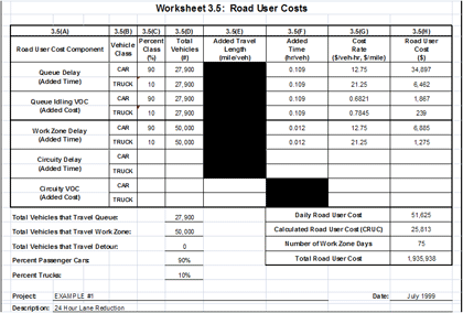
Figure 5. Sample screenshot from the Colorado WZ RUC program with input screens (left) and the productivity rates for various highway construciton activities and the corresponding lane capacity adjustment values (right).
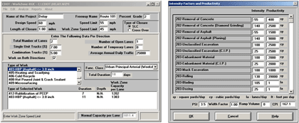
Figure 6. Sample screenshot from the Maryland LOPB tool, showing work zone flagger operation inputs.
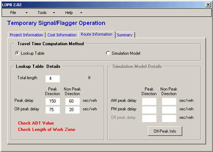
Figure 7. Sample screenshot from the Michigan CO3 spreadsheet, showing the construction cost module.
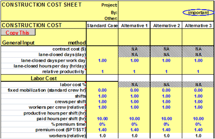
Inputs and Outputs
The basic inputs required for spreadsheet-based tools are:
- Work zone configuration- total number of lanes, number of closed lanes, lane width, normal and work zone speed, period of lane closure, normal and work zone lane capacity, etc.
- Traffic – hourly traffic demand, percent trucks, etc.
- Unit costs - hourly cost of travel delay, VOC for various vehicle types, etc.
The typical outputs reported by spreadsheet-based tools are travel delay time, number of queued vehicles, queue lengths, and in some cases, crash costs and emission estimates.
QUEWZ-98
Developed for the Texas DOT, QUEWZ-98 is a DOS-based analysis tool for evaluating freeway work zone lane closures. This tool simulates traffic conditions on a freeway segment with and without a lane closure in place and provides estimates of the queue lengths and additional road user costs resulting from work zone lane closures. The computed WZ RUC include travel time costs, VOC, and excess emissions. QUEWZ-98 can be used to identify time schedules for lane closures that will not produce excessive queue lengths and delays.
QUEWZ-98 has two output options:
- RUC option - this option analyzes a user-specified lane closure configuration and schedule of work activities. The outputs include estimates of traffic volumes, capacities, speeds, queue lengths, emissions, and additional road user costs for each hour affected by the lane closure.
- Lane closure schedule option - this option summarizes the hours of the day for a given number of closed lanes without causing user-defined excessive queuing.
QuickZone
Developed by FHWA, QuickZone is a sketch-planning tool for analyzing work zone mobility impacts such as traffic delays, queuing, and associated delay costs. The tool uses a link-node system for network layout and configuration and a deterministic delay estimation algorithm to estimate traffic delays and queuing.
This tool can be used in quantifying delay at the corridor level resulting from work zone related mobility constraints, identifying the mobility impacts of alternative project phasing plans, evaluating the impacts of various construction staging strategies, and supporting tradeoff analyses between construction costs and delay costs.
Capabilities
QuickZone can estimate travel delay time, queuing, and delay costs per vehicle hour for not only the roadway segment under work zone but also all available alternative segments of the roadway network defined in the program. This tool can be used in estimating traffic delays, potential backups, and associated delay costs for both an average day of work and for the whole life cycle of construction.
Inputs and Outputs
QuickZone requires the following data for evaluating mobility impacts in work zones:
- Network (Nodes and Links) - a network of nodes and links, segment (link) capacity, segment length, free-flow speed, and jam density.
- Traffic volume - hourly demand for each link and each day of a week.
- Project Information - project description, start date, project duration, yearly demand increase, yearly capacity decrease.
- Construction Phase Data - phase description, duration, infrastructure cost.
- Work Zone Plan - work zone start and end times, links and nodes affected by work zone, mitigation strategies, travel behavior (mode change, trip cancellation).
QuickZone reports the following outputs:
- Delay Graph - delay graphs comparing up to six phases of the project for the whole or any day of the week or delay graph for just a single phase.
- Travel Behavior Summary - a summary of the number of vehicles that choose one of the four travel behaviors determined for each phase: cancel trip, mode shift, hour time shift, and takes detours.
- Life Cycle Costing Graph - a summary of both delay and infrastructure costs for the project by year.
- Summary Table - provides estimates of queue length, delay, travel behavior, and costs. The table provides average, total, or maximum values for each phase as well as for the individual work zone plans within each phase.
Advantages and Disadvantages
Unlike similar spreadsheet based tools, QuickZone is capable of modeling the entire network for work zone mobility impact analysis. In addition, the tool evaluates traveler behavior to prevailing traffic conditions such as route changes, peak-spreading, mode shifts, and trip losses. While the interface is simple and easier to use, it may require more time and effort than similar spreadsheet-based tools. (Edara, P., Estimation of Traffic Impacts at Work Zones: State of the Practice, Report No. VTRC 06-R25, Virginia Department of Transportation, Richmond, VA, 2006.)
CA4PRS
CA4PRS is a construction schedule, staging, and traffic analysis tool that helps to identify optimal rehabilitation strategies by balancing project duration, lane closure strategies, and road user impacts. The traffic analysis module quantifies the impact of various work zone lane closure strategies on the traveling public in terms of WZ RUC and travel delay time, while the scheduling module estimates the required number of lane closures for project completion by taking into account the alternative strategies for pavement designs, lane closure tactics, and contractor logistics. The tool employs “what if scenarios” to determine which rehabilitation strategies maximize production without creating unacceptable traffic delays. (Lee, E. B., and C. W. Ibbs, Computer Simulation Model: Construction Analysis for Pavement Rehabilitation Strategies, ASCE Journal of Construction Engineering and Management, Vol. 131, No. 4, 2005.)
Capabilities
The CA4PRS tool can be used in establishing schedules, developing staging construction plans, estimating cost (A) + schedule (B) contracts, and calculating incentive and disincentive specifications for contracts. CA4PRS uses an HCM-based demand-capacity algorithm for quantifying mobility impacts; this tool also can be integrated with macro and microscopic traffic simulation tools to estimate road user delay costs arising from construction.
121BInputs and Outputs
CA4PRS uses the following input variables in evaluating “what-if” scenarios:
- Work zone constraints - number of lanes before and during construction, number of partial or full lane closures, roadway capacity, traffic composition, hourly demand, unit costs for delay time and VOC, lane width, lateral clearance.
- Construction window - nighttime closures, weekend closure, continuous closure, or combinations of the above.
- Pavement strategy – portland cement concrete (PCC) reconstruction, asphalt overlay of crack and seat PCC, or full-depth asphalt concrete replacement.
- Material constraints - concrete mix design and curing time or asphalt cooling time for asphalt
- Pavement cross section - thickness of new concrete or asphalt concrete, concrete pavement base types.
- Contractor’s logistical resource constraints - location, capacity, and numbers of rehabilitation equipment available (paver, batch plant, delivery and hauling trucks).
- Scheduling interfaces - mobilization/demobilization time, traffic control time, and activity lead-lag time relationships (e.g., lag time from demolition to PCC pavement installation), and buffer sizes.
The outputs reported by CA4PRS include:
- Mobility impacts - maximum delay time and queue length before and during construction.
- Road user costs - daily, per closure and total road user costs.
- Project costs - pavement, non-pavement and indirect costs.
- Traffic handling and management costs - daily traffic handling, extra TMP and incident management costs.
Figure 8 presents a sample screenshot showing lane closure analysis of I-80 pavement rehabilitation project using CA4PRS. (Pyeon, J. H., and E. B. Lee, "CA4PRS Application for Determination of Incentive/Disincentive Dollar Amount," CA4PRS Peer Exchange Workshop, St. Louis, MO, 2010.)
Advantages and Disadvantages
The primary advantage of CA4PRS is its capability to perform comprehensive analysis for WZ RUC computations by integrating traffic mobility analysis with construction scheduling, constructability and logistics, and pavement rehabilitation alternatives. It supports decision making by identifying the resource bottleneck limiting the project acceleration and allows users to specify the type of operations, concurrent or sequential. Another advantage is its ability to verify contractor submitted schedules. This tool can be used in conjunction with macroscopic or microscopic simulation tools for wider coverage of work zone influence and more in-depth impact analysis.
The current version of CA4PRS (version 2.5) is limited to pavement rehabilitation activities. Future versions of this tool plan to extend its scope to roadway widening, bridge and interchange replacement and include life-cycle cost analysis. WZ RUC computation using this tool is limited to travel delay costs and VOC; it does not compute emission or crash costs.
Figure 8. Sample screenshot showing lane closure analysis using CA4PRS.
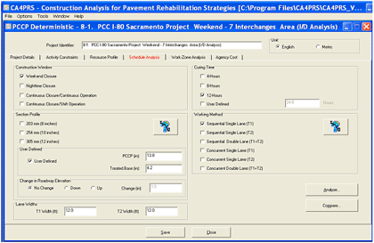
2.9.1.2 Work Zone Traffic Analysis Tools used by State DOTs
State DOTs typically use more than one tool for evaluating work zone impacts. These agencies typically use sketch-planning and HCM –based tools for projects where:
- The work zone mobility, safety, and economical impacts are expected to be low to moderate.
- The proposed work zone has limited impacts on the network.
- The agency resources are limited.
- The project completion time is not a major factor.
- Rough estimation of performance measures is sufficient.
State agencies also use sophisticated traffic analysis tools, such as microscopic and mesoscopic simulation tools, for projects where:
- The work zone mobility, safety, and economical impacts are expected be high.
- The work zone impacts are expected over a large geographic area.
- The project completion time is a critical factor.
- Accurate estimation of performance measures is a requirement.
2.9.2 Economic Analysis Tools
Economic analysis tools help decision makers to identify and quantify the value of economic costs and benefits of highway projects/programs over a multi-year period. These tools allow highway agencies to utilize the available resources to their best for maximizing benefits to the public. (Economic Analysis Primer, Office of Asset Management, Federal Highway Administration, U.S. Department of Transportation, August 2003.) Notable examples of economic analysis tools are discussed below.
RealCost
RealCost is a tool for conducting life cycle cost analysis in pavement design. Developed by the FHWA, this tool can be used for selecting a cost-effective pavement alternative among competing alternatives that offer essentially identical benefits. RealCost has a built-in tool for capacity flow analysis and for calculating road user costs associated with establishing a work zone. The capacity flow analysis is based on the traffic flow concepts presented in the 1994 edition of the HCM.
RealCost version 2.5 allows users to compute travel delay costs and VOC. Though illustrated in the interim technical bulletin, the computation of crash costs is not yet implemented in the software. RealCost has adopted the approach presented in NCHRPReport 133 for computing travel delay costs and VOC. Figure 9a presents a RealCost screenshot illustrating the hourly traffic demand and capacity analysis, lane closure timings, and resulting queue conditions for a typical work zone project. Figure 9b presents an example of various WZ RUC components computed for that project.
HERS-ST
HERS-ST is a benefit-cost analysis tool for selecting an economically efficient highway investment alternative among competing alternatives based on their potential impacts on highway condition, performance, and users. The benefits include reductions in user costs, agency maintenance costs, and externalities over the life of the improvement, while the costs include initial capital costs of the improvement. HERS-ST is designed to select only those projects where benefits will exceed initial costs. Developed by FHWA, HERS-ST has a suite of comprehensive submodels for computing various cost components of WZ RUC, including crash and emission costs.
MicroBENCOST
MicroBENCOST, developed under NCHRP Project 7-12, is an economic analysis tool for calculating road user benefit and costs of highway investments on a wide range of projects from individual intersection improvements to major road upgradings and construction of new roads. MicroBENCOST allows computation of travel delay costs, VOC, safety costs, and emission costs (considers the estimation of carbon monoxide only) for various work zone lane closure scenarios. Figure 10 presents a screenshot of work zone impact analysis functionalities of MicroBENCOST for use in WZ RUC computation.
BCA.Net
BCA.Net is the FHWA’s web-based benefit-cost analysis tool to support the highway project decision making process. The tool evaluates the economic merits of investment alternatives by comparing their relative costs and benefits. BCA.Net takes the capital costs, physical and performance characteristics, and forecast travel demand for the evaluation of a highway project.
The user specifies strategies for improvements and maintenance for a base case and an alternate case. The tool performs traffic impact analysis and calculates the agency and user costs and benefits for each case. The expected benefits and costs are compared on a time scale (i.e., discounted using the time value of money concept) to calculate the net benefits. The results of the simulation include various measures of economic worth such as the net present value, benefit-cost ratio, and internal rate of return for both base and alternate cases. For user costs, the BCA.Net tool is capable of calculating the following components: delay costs, VOC, crash and emission costs. Figure 11 presents a screenshot of RUC analysis functionalities of BCA.Net.
Figure 9.a Screenshot showing the WZ RUC analysis in RealCost version 2.5 – An example of work zone traffic analysis illustrating lane closure timings and queuing conditions.
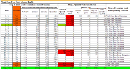
Figure 9.b Screenshot showing the WZ RUC analysis in RealCost version 2.5 – An example showing computed RUC components for a typical work zone project.
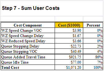
Figure 10. Screenshot showing the work zone analysis functionalities of MicroBENCOST.
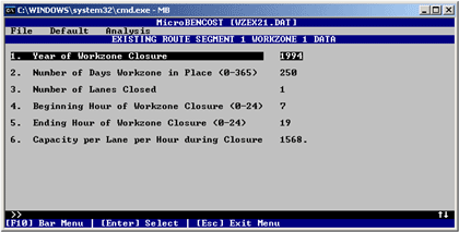
Figure 11. Screenshot showing the RUC analysis functionalities of BCA.Net.
You will need the Adobe Reader to view the PDFs on this page.
previous | next