DC-295 Washington, DC
In 2006, the District of Columbia Department of Transportation (DDOT) deployed an ITS system on Highway 295 in Washington, DC. The system covers an approximately 7 mile stretch of DC-295, with some components on adjacent routes. DDOT designed and procured the system to help alleviate congestion and provide real-time information to motorists in the field and via a Web site. DDOT's main goals for the ITS system were to monitor conditions and improve mobility and safety through the work zone. The location and system layout are shown in Figure 1.
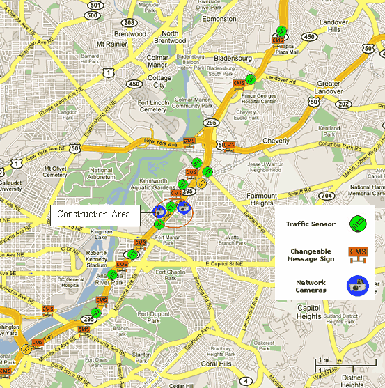
Figure 1. DC-295 Work Zone Area and ITS Layout
Based on predetermined delay and speed thresholds, the system provided real-time delay and speed information and, as needed, recommended alternate routes via dynamic message signs (DMS) for high congestion periods. The main goal of the system was to monitor conditions and manage traffic during lane closures due to their potential to produce abnormally large traffic backups and create potential for crashes outside the work zone.
The main objectives of the system were to:
- Reduce work zone-related congestion through a heavily traveled urban corridor.
- Provide delay and speed information to warn motorists of slowed traffic ahead.
- Provide information to commuters and DOT personnel via a Web site.
- Build public confidence in real-time traveler information.
The main objective of this evaluation was to determine the effect of the system on traffic conditions and quantify the benefits of the system.
Study Site Work Zone
DDOT incorporated a special provision for the Real-Time Work Zone System (RTWS) for both the northbound and southbound directions of Kenilworth Avenue (DC-295) from Foote Street to Lane Place Bridge over Nannie Helen Burroughs Avenue, in Northeast Washington DC.
Kenilworth Avenue is a barrier separated, six-lane freeway and serves as a major highway link between other major routes within the District, including I-395, and the Baltimore-Washington Parkway. DC-295 is a heavily traveled commuter route, carrying over 100,000 vehicles daily between Maryland and Washington, DC.
DDOT issued the Notice to Proceed for construction on April 2, 2007. The project consisted of the widening of Kenilworth Avenue to include improved shoulders and the realignment of the Nannie Helen Burroughs Avenue intersection with Kenilworth Terrace and Kenilworth Avenue on and off ramps. Improvements were also made to the intersections of Lane Place, 42nd Street, Jay Street, and Hayes Street with the collector-distributor road of Southbound Kenilworth Avenue. The Kenilworth Avenue bridge section over Nannie Helen Burroughs Avenue was replaced by a new two-span steel multi-girder superstructure. Several other bridges were reconstructed utilizing steel multi-beam superstructures and widened to provide semi-integral abutments. Other work included installation of traffic signals, lighting, and signing.
ITS Description
DDOT designed the ITS system to monitor traffic conditions within and in advance of the work area from each direction. The system components included:
- A central base station equipped with processing software and wireless communications to link the system components.
- 13 portable DMS remotely controlled via the field station.
- 8 portable speed sensors.
- 2 portable Remote Traffic Microwave Sensors (RTMS).
- 3 pages to provide notification to designated personnel when congested conditions occur or when devices malfunction.
- 2 video cameras to provide live video feeds of the work zone area.
DDOT moved some of the components and added several new components to allow the system to account for an additional ongoing Maryland DOT construction project.
Measures and Metrics
The system vendor collected and archived traffic data from November 1, 2006, through August 15, 2007, resulting in more than 1 million data records. Since the system detectors covered a large area, the data collection plan for this site relied solely on system detector data for analysis. The data archives allowed the study team to establish a baseline prior to ITS implementation (without ITS) for comparison with the period when the system was active (with ITS).
The study team developed a database tool to catalogue and display data from the nearly 1 million records provided by the system vendor. Due to its limited use in comparison of construction-related traffic patterns, baseline data collected prior to the construction start date of April 2, 2007, was used as back up information. The system was turned on to traffic on April 13, 2007. Data for 11 days prior to system start were available for comparison with data archived between April 14, 2007 and August 15, 2007 (when the ITS was actively deployed).
The study team developed two key hypotheses based on the goals for the system. The hypotheses and associated measures and data sources for testing each are shown in Table 1 below.
| Hypothesis | Measures of Effectiveness | Data Sources |
|---|---|---|
| The use of ITS in work zones will divert travelers to alternate routes during times of work zone congestion | Demand patterns on mainline and alternate routes | Sensor data |
| The use of ITS in work zones will reduce congestion | Demand patterns on mainline and alternate routes, queue lengths | Direct observations, sensor data |
Findings
The archived data for this site showed some general trends, especially in the level of recurring congestion for this area. The study team observed the distinct commute pattern into the District in the morning (southbound) and out of the District in the afternoon (northbound) from the data. DDOT anticipated that adding in capacity restrictions from the work zone would add non-recurring congestion to this daily pattern. Therefore, the system covered the corridor along a stretch of approximately 10 miles.
The data suggests higher levels of recurring congestion for the area than non-recurring congestion caused by the work zone. This may be in part due to the early phases of work – construction is scheduled to continue into 2008, and additional activities in the future may impact traffic to a greater extent than observed within the timeframe of this study. However, several findings indicate positive benefits of the system during the 2007 construction season.
Construction Activity Information
To assess the level of impact from construction activities, the study team obtained construction log information and capacity reduction information from the DDOT construction management consultant. Construction inspectors and field engineers recorded information in activity logs for each day that work occurred as shown in Tables 2 and 3. Time periods of interest included those in which lane closures were in place and those in which incidents occurred. The recorders made notes on incidents within the work zone and at the approaches, maximum queue lengths, and specific activities that occurred. The study team parsed applicable notes for the days of interest during the periods both "without ITS" and "with ITS." While crashes likely occurred along the corridor during construction, the DDOT construction management consultant cited no documented work zone-related crashes during the data collection time period.
| Date | Time of Day (Beginning) | Time of Day (End) | Crashes Observed | Maximum Observed Queue Length | Activity Notes |
|---|---|---|---|---|---|
| 4/5/2007 | 10:00 AM | 3:30 PM | — | 1200 feet | Closed northbound outside lane on Kenilworth Avenue (clear and grub) |
| 4/6/2007 | 10:00 AM | 2:00 PM | — | 200 feet | Closed lane on northwest service road (clear and grub) |
| 4/9/2007 | 10:00 AM | 3:30 PM | — | 200 feet | Closed southbound lane near bridge 48 for deck demolition |
| 4/10/2007 | 10:00 AM | 3:30 PM | — | 200 feet | Closed southbound lane near bridge 48 for deck demolition |
| 4/10/2007 | 10:00 AM | 3:30 PM | — | 200 feet | Phase 1 – early maintenance of traffic plan implementation |
| 4/11/2007 | 10:00 AM | 3:30 PM | — | 200 feet | Closed southbound lane near bridge 48 for deck demolition |
| 4/12/2007 | 10:00 AM | 3:30 PM | — | 1200 feet | Closed lane on southbound Kenilworth Avenue (demolition) |
All lane closures occurred during off-peak hours. Of the "without ITS" days where lane closures were in place, the data for the southbound direction showed recurring congestion trends from approximately 7:00 a.m. until approximately 10:00 a.m. Data for one day showed recurring congestion from approximately 3 p.m. until approximately 6 p.m.
| Date | Time of Day (Beginning) | Time of Day (End) | Crashes Observed | Maximum Observed Queue Length | Activity Notes |
|---|---|---|---|---|---|
| 4/13/2007 | 10:00 AM | 3:30 PM | — | 1200 feet | Closed southbound lane for MOT Pavement Marking |
| 4/14/2007 | 10:00 AM | 3:30 PM | — | 200 feet | Closed southbound lane for Phase I – Early MOT |
| 4/16/2007 | 10:00 AM | 3:00 PM | — | 1200 feet | Closed southbound lane to place portable concrete barrier |
| 4/17/2007 | 10:00 AM | 3:00 PM | — | 200 feet | Closed southbound lane to place portable concrete barrier |
| 4/18/2007 | 10:00 AM | 3:30 PM | — | 200 feet | Closed southbound lane for pavement marking and to place portable concrete barrier |
| 4/19/2007 | 10:00 AM | 3:30 PM | — | 1200 feet | Closed northbound lane for Phase I – MOT |
| 4/20/2007 | 10:00 AM | 3:30 PM | — | 1200 feet | Closed northbound lane for Phase I – MOT |
| 4/24/2007 | 10:00 AM | 3:30 PM | — | 1200 feet | Closed southbound lane to install storm water catch basin |
| 4/25/2007 | 10:00 AM | 3:30 PM | — | 1200 feet | Closed southbound lane to install storm water catch basin |
| 4/28/2007 | 10:00 AM | 3:00 PM | — | 1200 feet | Closed southbound lane for MOT pavement marking |
| 5/14/2007 | 10:00 AM | 2:00 PM | — | 1200 feet | Closed southbound lane for MOT pavement marking |
| 5/15/2007 | 10:00 AM | 3:30 PM | — | 1200 feet | Closed southbound lane for MOT pavement marking |
| 5/16/2007 | 10:00 AM | 3:30 PM | — | 1200 feet | Closed southbound lane to place portable concrete barrier |
| 5/17/2007 | 10:00 AM | 3:30 PM | — | 1200 feet | Closed southbound lane to place portable concrete barrier |
| 5/18/2007 | 10:00 AM | 3:30 PM | — | 1200 feet | Closed southbound lane to place portable concrete barrier |
| 6/2/2007 | 4:00 AM | 2:00 PM | — | 1200 feet | Closed northbound lane for MOT pavement marking |
| 6/4/2007 | 10:00 AM | 3:30 PM | — | 1200 feet | Closed northbound lane for MOT pavement marking |
| 6/5/2007 | 10:00 AM | 3:30 PM | — | 1200 feet | Closed northbound lane to place portable concrete barrier |
| 6/7/2007 - 6/14/2007 | 10:00 AM | 3:30 PM | — | 1200 feet | Closed northbound and southbound lanes to demolish median (daily) |
| 6/18/2007 - 6/30/2007 | 10:00 AM | 3:30 PM | — | 1200 feet | Closed northbound and southbound lanes to demolish median (daily) |
Project managers documented similar information for July and August to assist with the analysis. In some cases, the data showed queues that were longer than those documented by project personnel (likely recurring queues not caused by the work zone directly). In other cases, sensor data did not show any congestion on some of the days where project managers documented some work zone related queuing. Consequently, documented queues were relatively short and non-recurring congestion appeared to be managed to a minimum extent as part of the maintenance of traffic plans (i.e. off-peak lane closures, etc.).
Traffic Queue Analysis
The study team began the analysis by sorting traffic data from system detectors for preliminary inspection to determine the potential for use in the analysis. The archived traffic data consisted of more than 1 million records covering a time period from November 2006 through August 2007. The data set was very complete and inspection showed reasonable patterns of traffic volumes, speeds, and associated DMS messages. Data were not available for a small number of days and other short time periods due to communication interrupts and archiving issues.
The study team performed an analysis to compare queues documented by construction managers with those observed by the system. Since the system covered a large area with multiple detector locations (this site had a very large number of detectors compared with most of the other sites), the potential for determining queues was high. Documented queues extended to a maximum of approximately 1/4 of a mile, while queues from system detector data reached nearly 2 miles in some instances. The study team calculated queues using detector spacing for time periods where speeds dropped below 30 miles per hour (mph). Figure 2 shows average southbound speed by time of day for April 13, 2007, the first day the DMSs were turned on to traffic. The resulting queue was approximately 1 mile compared with the 1/4 mile estimate. The longer queue length could be caused by recurring congestion or an incident outside of the work zone area. Due to the large difference between estimated and observed queue lengths on nearly all of the data collection days, the analysis of queues before and after implementation proved inconclusive. The wide gap between observed queue and system detected queue may have been caused by the determination of what constitutes a queue. The 30 mph threshold is common for a rolling queue and is easier to determine from data as opposed to field observations, but the sensitivity to observed speed may differ due to the level of recurring congestion normally seen in urban areas such as Washington, DC.
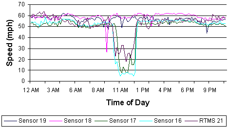
Figure 2. Average Speed by Time of Day – April 13, 2007
Based on the data shown in Figure 2, the system posted messages showing 55 to 60 minute delays on DC-295 and recommended, on DMSs located on a perpendicular route, that motorists seek an alternate to DC-295.
Traffic Volumes and Diversion Patterns
The study team also analyzed volume levels for days with and without ITS that experienced similar impacts from construction or had similar levels of congestion. Since most "without ITS" days showed mostly recurring congestion during peak hours and showed no congestion during lane closure time periods, the study team compared some of the "without ITS" days to "with ITS" days to see if the volumes changed when messages recommended alternate routes. The study team also compared some days within the "with ITS" period to see if volume levels showed interesting trends.
For two similar Tuesdays (April 10 and May 15), the volume levels were almost exactly the same except from approximately 10 a.m. until 1 p.m., a time period where the system posted delay information and recommended that motorists seek an alternate route to southbound DC-295 (see Figure 3). During this time period, as much as a nearly 90 percent less volume was observed on May 15 compared with April 15. As shown in Table 4, the data showed 3 to 89 percent lower observed mainline volumes, with an average of 52 percent over these nine observations. This shows that the system likely reduced delay substantially for motorists by providing them with information to better enable them to choose an alternate route. It should be noted that based on the data available, it is not possible to determine what portion of the lower mainline volume was due to diversion versus demand reduction versus congestion.
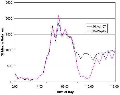
Figure 3. Volume Levels by Time of Day
| Time Period | Observed Volumes for April 10, 2007 | Observed Volumes for May 15, 2007 | Difference | Percentage Difference |
|---|---|---|---|---|
| 10am – 10:30am | 912 | 435 | 477 | 52% |
| 10:30am – 11am | 723 | 151 | 572 | 79% |
| 11am – 11:30am | 886 | 168 | 718 | 81% |
| 12pm – 12:30pm | 890 | 98 | 792 | 89% |
| 12:30pm – 1pm | 831 | 148 | 683 | 82% |
| 1pm – 1:30pm | 679 | 452 | 227 | 33% |
| 1:30pm – 2pm | 862 | 742 | 120 | 14% |
| 2:30pm – 3pm | 908 | 574 | 334 | 37% |
| 3:30pm – 4pm | 921 | 890 | 31 | 3% |
During periods of congestion, volume counts are impacted because queuing and congestion allow fewer vehicles to cross in front of the sensor due to lower speeds. An exact measure of demand involves estimating the number of vehicles in the queue—these vehicle estimates should be added to the volume counts to get a true demand value. Due to the sporadic nature of speeds below the queue threshold and the absence of expected patterns (the study team often observed queues at two sensors but free flow conditions at a sensor in between the two), the data proved inconclusive. This limitation is inherent in many studies, as the data collection plan would need to account for field observations and normally is too costly and difficult to plan for. It is important to understand the effects of congestion on throughput; however, the very large change in volume shows that, by alerting motorists on another route to avoid DC-295, the system likely had a positive impact on travel through the corridor.
For the northbound direction, the study team compared one day "without ITS" to one day "with ITS." These two dates were April 6 and April 20, respectively. No clear trend was apparent from the data, although the study team observed similar large percentage differences in volumes for some time periods. On April 20, the system recommended that motorists seek an alternate route from 2:22 p.m. until 4:10 p.m.—a timeframe that showed lower volumes during the "without ITS" period, as seen in Figure 4. The posted messages showed the delay and recommended that motorists seek an alternate. The difference was that the delay was lower in this case than the previous case—posted delays did not exceed 15 minutes on April 20.
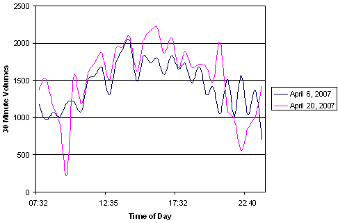
Figure 4. Volume Levels by Time of Day
The data displayed above shows the best examples, from all the data, of how motorists were impacted. While the system alleviated congestion on the mainline, alternate routes should also be monitored to the extent feasible to avoid shifting congestion to another route or corridor. For this study, the study team was unable to observe the alternate routes due to cost.
DMS Messages
Throughout the deployment, the system posted 85 different types of messages at different times. The system often posted delay, speed ahead, and other caution messages warning motorists of the construction activities ahead.
The system used several preprogrammed messages, and operators had the ability to override the system and post messages manually as needed. Examples of the types of messages and variations are shown below.
Messages Showing Delay
- X MINUTE DELAY AHEAD PLEASE USE CAUTION.
Messages Showing Speed Ahead
- X MPH SPEED AHEAD SLOW DOWN.
- X MPH SPEED AHEAD PREPARE TO STOP.
- X MPH SPEED DC-295 SLOW DOWN.
- X MPH SPEED DC-295 PREPARE TO STOP.
Example Test Message
- MESSAGE MESSAGE MESSAGE TEST TEST TEST.
Messages Encouraging or Requiring Diversion
- X MIN DELAY AHEAD SEED ALT. ROUTE.
- X MIN DELAY ON 295-S SEEK ALT. ROUTE.
- X MIN DELAY DC-295N SEEK ALT. ROUTE.
- X MIN DELAY ON DC-295S SEEK ALT. ROUTE.
- X MIN DELAY ON DC-295 SEEK ALT. ROUTE.
- S CAP ST BRIDGE CLOSED TRUCK & VEHICLE TRAFFIC.
- S CAP ST BRIDGE CLOSED VIRGINIA TRAFFIC USE 295S.
- S CAP ST BRIDGE CLOSED USE NEW YORK AVENUE.
Messages Showing General Traffic Conditions
- BRIDGES FREEZE BEFORE ROADWAY DRIVE W/CAUTION.
- S CAP ST BRIDGE CLOSED TRUCK & VEHICLE TRAFFIC.
- WORK ZONE DC-295 PLEASE USE CAUTION.
- WORK ZONE AHEAD.
- WORK ZONE AHEAD PLEASE USE CAUTION.
Other Messages
- CLICK IT OR TICKET.
- SOCCER GAME AT RFK THURSDAY 5PM-9PM.
- DRIVE WITH CARE.
DDOT added sensors and message boards on June 29, 2007, to account for a construction project in nearby Maryland. DDOT purchased two additional sensor trailers and one additional message board for the Maryland project. The additional sensor trailers allowed DDOT to detect congestion due to the Maryland project and to alert motorists approaching that project within the DC project area. The system combined delays from the two projects as appropriate to determine the total delay. Also, DDOT used the additional message board to expand motorist information south to the South Capitol Street Bridge, which allowed messages relating dates and times of the bridge closing to be conveyed to travelers. The system also posted South Capitol Street Bridge status messages on the Baltimore-Washington Parkway in Maryland and before the exits to Route 50 and New York Avenue.
Overall, the real-time information system deployed on DC-295 in Washington, DC appeared to effectively divert traffic to unsigned, unspecified alternate routes during times of significant congestion. There was an average of 52% lower mainline volume observed (combination of diversion, demand reduction, and congestion). It should be noted that the results include potential reduced throughput due to queues and congested conditions (likely significant for the higher end of the range). However, even considering the congestion impacts on throughput, these results show that the system likely reduced delay substantially for motorists by providing them with information to better enable them to choose an alternate route. It should also be noted that this is an urban area with a large number of commuter trips. Based on the data available, it is not possible to determine what portion of the lower mainline volume was due to diversion versus demand reduction versus congestion.
Tips and Lessons Learned
Deployment Tips and Lessons Learned
Coordinate with neighboring States and local agencies. DDOT coordinated with other local agencies in addition to coordination with the Maryland State Highway Administration on the neighboring construction project. When the South Capitol Street Bridge was closed, DDOT coordinated with the local jurisdictions to divert over 72,000 vehicles for a 2-month period while the construction was ongoing. The coordination process helped DDOT plan for outreach to the media to help motorists avoid the already congested DC-295 corridor while it was under construction.
Flexibility in system configuration is important. DDOT successfully modified the original system layout to account for impacts from a separate construction project in a neighboring state.
Allow time for obtaining right of way use permits for equipment installation. The vendor used by DDOT noted that time was required to get approval of these permits before they could place the equipment in the field.
Secondary benefits of managing recurring congestion along heavily traveled urban corridors may also be achieved. DDOT successfully used the system to manage recurring congestion along the heavily traveled DC-295 corridor.
Evaluation and Research Tips and Lessons Learned
A successful evaluation of a work zone ITS deployment relies heavily on the cooperation of each entity involved. As the final evaluation performed under this study, the study team reaffirmed many of the previous evaluation and research lessons learned from the other sites. For this study all parties were helpful in obtaining necessary information.
Need to be able to verify conditions in the field as they occur. Often, with archived data, evaluators are unable to validate data and findings as conditions occur in the field. A measure in addition to volume is commonly needed to measure the level of congestion and congestion impacts on throughput.
Previous | Next