Printable Version [PDF 123 KB]
To view PDF files, you need the Adobe
Acrobat Reader.
Contact Information: Paul Pisano at Paul.Pisano@dot.gov
Road Weather Management Progam Web Site
U.S. ROAD WEATHER MANAGEMENT PROGRAM -
SENSOR SITING AND WEATHER INFORMATION INTEGRATION PROJECTS
Paul A. Pisano
Federal Highway Administration, Road Weather Management Program, Washington, D.C.
Lynette C. Goodwin
Mitretek Systems, Inc., Intelligent Transportation Systems, Washington, D.C.
Andrew D. Stern
Mitretek Systems, Inc.; Oceanic, Atmospheric and Space Systems; Falls Church, VA
1.0 Introduction
This paper reports on two key projects of the U.S. Federal Highway Administration (FHWA) Road Weather Management Program. The program partnered with the Aurora Program, and the Snow and Ice Cooperative Program of the American Association of State Highway and Transportation Officials (AASHTO) to create Road Weather Information System (RWIS) Environmental Sensor Station (ESS) Siting Guidelines. The guidelines provide a set of recommendations to support the uniform siting of sensor stations that collect road and weather condition observations.
The FHWA also sponsored a study on the Integration of Emergency and Weather Elements into Transportation Management Centers (TMCs). The study documented how weather information and systems are being integrated into transportation operations. The investigators found that by providing accurate and timely road weather information, effectively integrating weather and traffic information, and providing automated alerts and decision support, TMC operators are able to better manage traffic, dispatch maintenance forces, and address weather-related emergencies. These projects illustrate how the collection of road weather observations and the use of these observations to produce road weather information can be used to improve roadway operations. The lessons learned from these projects will help facilitate the development of a nationwide, integrated road weather observation network—known as Clarus—and aid in mitigating the effects of adverse weather on U.S. highways.
2.0 Road Weather Management Program Overview
The FHWA Road Weather Management Program seeks to better understand the effects of weather on roadways, and develop strategies and tools to mitigate those effects. The Road Weather Management Program often collaborates with the FHWA Intelligent Transportation Systems (ITS) Joint Program Office, the FHWA Office of Transportation Management, and other partners to promote and conduct coordinated research aligned with program goals.
Road Weather Management Program goals include enhancing observing capabilities and advancing the state-of-the practice in weather-responsive traffic management and winter road maintenance. Envisioned is a system that provides "Anytime, Anywhere Road Weather Information" for road operating agencies and road users, as well as a robust, competitive market for road weather services.
3.0 Environmental Sensor Station (ESS) Siting Guidelines
A Road Weather Information System (RWIS) is comprised of Environmental Sensor Stations (ESS) in the field, a communication system for data transfer, and central systems to collect and display field data from several ESS. Transportation agencies strategically deploy ESS on or near highways to help traffic operators and maintenance managers make more informed operational decisions. As shown in Figure 1 there are three ESS sensor categories that provide information on weather-related road conditions.
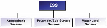
Figure 1 - ESS Categories
The RWIS ESS Siting Guidelines include recommendations that encourage uniformity in sensor siting and in the application of the road weather observations. The recommendations are not standards, but rather a set of criteria to consider when deploying ESS. The guidelines can be used to aid transportation agencies in the selection and installation of ESS equipment, to maximize return on investment, and to improve the integration of road weather information with other meteorological data to increase usefulness.
Section 1 of the guidelines document defines ESS and RWIS concepts, and highlights key benefits of employing ESS as part of an Intelligent Transportation System. Section 2 provides an overview of road weather elements of interest to road operations and maintenance personnel to help them assess their information requirements and make decisions about which sensors to deploy. Section 2 also differentiates between regional and local ESS sites and encourages partnerships to share road weather observing resources. Sections 3 and 4 include guidance for selecting an ESS site and siting recommendations. Section 5 addresses other considerations such as power, communications, safety, and ESS metadata.
3.1 Recommended Siting Criteria
The RWIS ESS Siting Guidelines include recommended criteria for siting the observation tower and for placing sensors on or adjacent to the tower. The following paragraphs summarize these siting recommendations.
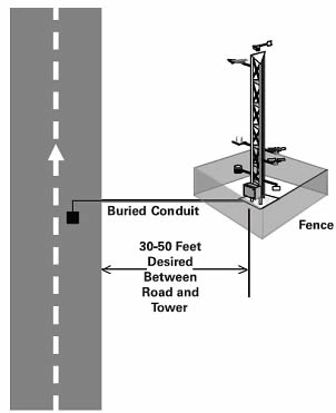
Figure 2 - Desired Tower Location Relative to Roadway
As shown in Figure 2, towers used for atmospheric and pavement applications should be sturdy and outfitted with instrument booms to reduce sensor contamination by turbulence and wind flow. Towers are most frequently installed within 30 to 50 feet (9 to 15 meters) of the paved road surface.
If possible, the tower base should be at the same elevation as the road surface. Towers should be sited on relatively flat terrain away from steep slopes, which could impact wind measurements. Sites near steep road cuts, standing water, and bedrock should also be avoided. A fence that is at least 15 feet (5 meters) from the tower should be installed to prevent vandalism. The fence should not obstruct any sensors on the tower or interfere with maintenance activities.
Figure 3 depicts the recommended locations of sensors mounted on the tower. An air temperature/dew point sensor should be housed in a radiation shield and mounted 5 to 6.5 feet (1.5 to 2 meters) above the ground. The sensor should be on a boom extended at least 3 feet (1 meter) from the tower in the predominant wind direction. A wind speed and direction sensor (or anemometer) should be positioned 33 feet (10 meters) above ground level. The wind direction sensor should be set on true north (rather than magnetic north). Visibility sensors should be installed at a height of 6.5 to 10 feet (2 to 3 meters) to represent driver-level conditions. Optical sensors should be installed to prevent the sun and stray light sources from entering the receiver element.
Solar radiation sensors should be installed at least 10 feet (3 meters) from the surface to avoid radiation from reflective surfaces, debris contamination, and shading from obstructions. Both visible and infrared cameras should be installed where they are able to obtain a clear line-of-sight without interfering with the operation of other sensors. If cameras are used for visibility measurements, the camera should be installed as close as possible to the driver's level of view.
Optical precipitation sensors—which measure rate, type, and amount—should be installed at a height of 10 feet (3 meters) and located away from traffic, as they are susceptible to vibration. Exposure is the primary consideration for siting precipitation accumulation sensors. The tipping bucket and weighing rain gauge are the most common ESS precipitation accumulation sensors. Precipitation accumulation sensors should be placed in as open an area as possible, away from the roadway to prevent splashing, and away from areas of possible blowing or drifting snow. To increase measurement accuracy, a wind shield should be used. Snow depth sensors, which are based on ultrasonic or infrared emissions, should be installed perpendicular to the ground surface at a height of approximately 3.5 feet (1 meter) and should be mounted to avoid vibrations.
Pavement sensors can be installed where pavement conditions are representative of general road conditions or where specific road weather problems (e.g., black ice, flooding) are likely to occur. Subsurface temperature and moisture sensors should be installed at a depth of 12 or 18 inches (30.5 or 45.5 centimeters). The installation location should be representative of sub-grades in the area to include the presence or absence of water, similar soil types, and pockets of foreign materials.
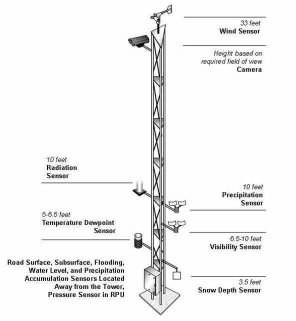
Figure 3 - Typical Location of Tower-Based Sensors
For water level and road flooding applications, standpipes are typically used. Standpipe masts are vertical pipes ranging from 3 to 12 inches (7.6 to 30.4 centimeters) in diameter and up to 10 feet (3 meters) tall. Wind, air temperature, or other sensors should be mounted high enough on masts to eliminate the environmental effect caused by the standpipe. For water-level sensors, standpipes should be located adjacent to the low point of the flood-prone road segment in a portion of a stream or river with low turbulence (i.e., steady flowing). If installed on or adjacent to a bridge, the sensors should be sited on the downstream side to minimize damage from floating debris.
An important consideration for the effective use of road weather data from ESS is the documentation and distribution of site metadata. Metadata are defined as "data about data." In the case of the RWIS ESS, metadata should include station and sensor locations and a history of any changes in the metadata. The siting guidelines include recommended metadata items for ESS and additional metadata items that can provide more useful information to road weather data users.
The collection of road weather information can provide decision support to transportation managers and contribute to more accurate weather forecasts. The recommendations in the RWIS ESS Siting Guidelines are designed to encourage uniformity while satisfying as many road weather monitoring, detecting, and prediction requirements as possible. The guidelines recommend that siting decisions be made by a team comprised of traffic operations personnel, road maintenance managers, and weather experts.
4.0 Integration of Emergency and Weather Elements into Traffic Management Centers (TMCs)
Data collected from ESS can be used by traffic management personnel to ensure road safety, improve mobility, and provide the public with traveler information. The Traffic Management Center (TMC) Integration project documents how weather and emergency information are currently being integrated into transportation operations.
Weather integration involves providing TMC operators with accurate, timely, road weather information, effectively integrating weather and traffic information, and providing automated notification and decision support tools. During the integration study 38 TMCs across the United States were contacted or visited to investigate five dimensions of weather information integration including operational integration, physical integration, technical integration, procedural integration, and institutional integration.
Operational integration involves how data are shared and used by TMCs and associated agencies, organizations, and systems to support traffic operations. Physical integration represents how agencies, organizations, and systems are physically linked or collocated for data sharing in support of traffic operations. Technical integration illustrates how data are exchanged and shared using a range of means from verbal exchanges to automated electronic exchanges.
Procedural integration describes the development and use of policies, plans, and procedures that support integrated traffic operations in a TMC environment. Institutional integration characterizes the level of commitment and collaboration within and between agencies and organizations.
4.1 Current Weather Integration in Traffic Management Centers (TMCs)
Today there are varying levels of weather integration in TMCs across the U.S. During the study, investigators found that continuously available weather information are provided to TMC personnel in a coordinated manner. There is seamless integration of multiple data sources and subsystems, including the automated collation of weather and traffic information from multiple sources. Some TMCs use automated notification systems that trigger alarms to notify operators of dangerous weather-related conditions. They also utilize automated decision support systems that make recommendations based on proven weather mitigation strategies. Institutionally, there is awareness and communication between traffic management and weather communities that enables collaboration and enriched application of weather information for traffic management applications.
4.2 Recommendations for Weather Information Integration
Based upon the findings of the integration study, investigators made several recommendations to enhance weather integration in TMCs. Traffic managers and operations personnel need more awareness of how weather impacts their roadway networks, training on how weather information may be used in traffic operations, and education on the benefits of integrating road weather information in TMC operations.
Weather integration in TMCs could be fostered if route-specific weather information is integrated with advanced traffic management systems. To achieve such integration traffic management personnel can conduct a TMC weather information use self-assessment and develop an integration plan. The inputs and steps for a self assessment are shown in Figure 4.
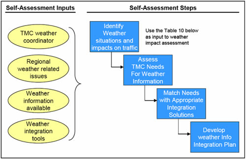
Figure 4 - Recommended TMC Self-Assessment Process
5.0 Conclusion
The siting guidelines can be utilized to improve the usefulness of observation information collect from ESS. This information can be integrated into transportation operations to provide decision support, contribute to tailored weather forecasts, and ultimately enhance road safety and traffic flow. Each region of the country presents a unique set of challenges to effective weather integration based on climate, geography, politics, and transportation systems, and resources.
Although the practice of weather information integration in TMCs is in its infancy, the study illustrated the value of an integrated approach to transportation operations during inclement weather. Transportation agencies can benefit by applying the lessons learned from these projects. Both the ESS siting guidelines and the final report capturing the findings of the TMC integration study can be found on the FHWA Road Weather Management website at: www.fhwa.dot.gov/weather.
6.0 References
Aurora Program Web Site, 2005: http://www.aurora-program.org/.
Battelle, Iteris, Meridian Environmental Technology Inc., and URS, 2005: Integration of Emergency and Weather Elements into Transportation Management Centers, Draft Final report, prepared for the Federal Highway Administration (FHWA).
FHWA, 2005: Road Weather Management Program Web Site, Office of Transportation Operations, https://www.fhwa.dot.gov/weather.
FHWA, 2005: Clarus Initiative Web Site, ITS Joint Program Office, http://www.clarusinitative.org.
SAIC, Meridian Environmental Technology Inc., and T & S Diversified Inc., 2005: Road Weather Information System Environmental Sensor Station Siting Guidelines, prepared for the FHWA, http://ops.fhwa.dot.gov/publications/ess05/ess05.pdf.
Snow and Ice Pooled Fund Cooperative Program Web Site, 2004: American Association of State Highway and Transportation Officials (AASHTO), http://www.sicop.net.