Appendix K: Coding Techniques for Complex Situations
This appendix briefly explains how to model some complex situations or applications in CORSIM. Some of the techniques presented in this appendix are methods to work around limitations in CORISM. This discussion is prefaced with a caution that other tools may be better suited for modeling a given complex situation.
Roundabouts
CORSIM does not explicitly model roundabout movements; however, it is possible to indirectly model a roundabout movement. There may be some scenarios where a roundabout needs to be modeled to match the operation of the real world. Use of this capability is not recommended if the purpose of the analysis is directly affected by the roundabout operation. For example, if an intersection adjacent to the roadway being modeled is designed as a roundabout, it may be possible to model that intersection as a roundabout without jeopardizing the main objectives of the analysis.
A problem CORSIM has in modeling a roundabout is that the minimum length of a link is 15.2 m (50 ft), and the link length by definition includes the upstream intersection in the length. These two conditions cause problems in modeling a roundabout due to the short link sections necessary for a roundabout. Very small roundabouts may be impossible to model and animate. Short links are also difficult to curve into a realistic looking roundabout.
Figure 104 shows a roundabout displayed in TRAFVU. For this roundabout, nodes were placed at each roundabout approach, and yield signs were placed at the approaches. Within the roundabout, short links were coded to connect the nodes at the approaches. As shown, it is possible to create a roundabout in CORSIM; however, the performance of the model should be carefully calibrated with real-world data to ensure that the model represents a reasonable match with real-world conditions.
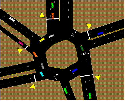
Figure 104. Illustration. Roundabout example in TRAFVU.
Ramp to Ramp Splits
When coding freeway ramps, existing FRESIM convention calls for one branch to be defined as the freeway mainline and the other to be the ramp. This causes problems when modeling freeway-to-freeway ramps. Another limitation with freeway ramps is that FRESIM does not allow a ramp to be further split into two ramps, which an analyst may want to code when two freeways have ramps that merge onto the same ramp. There are a couple of possible workarounds to these ramp to ramp limitations.
One workaround is to separate the ramp links with “dummy” freeway mainline sections. To do this, create small freeway segments that have dummy entry nodes with no volume. This allows ramp segments to merge and diverge from the dummy freeway segment. Figure 105 shows the dummy freeway sections that connect the ramp links highlighted in red (or darker link).
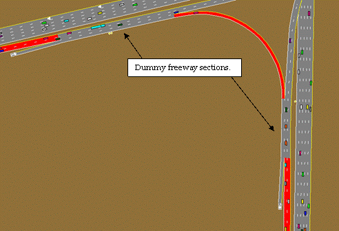
Figure 105. Illustration. Dummy freeway sections.
Another workaround is to use surface street (NETSIM) sections to separate ramp links. The problem with this approach is the car-following on the surface street sections is different than on the freeway/ramp sections. Vehicles will slow down to create a larger headway than is on the freeway section. Figure 106 shows a surface street section inserted in a freeway interchange to allow merging of ramp lanes.
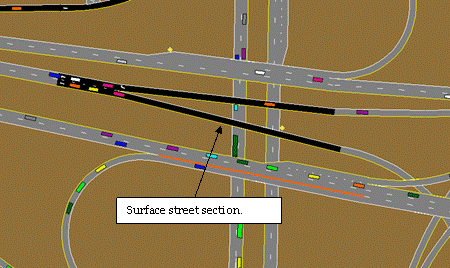
Figure 106. Illustration. Surface street section.
U-turns
CORSIM does not explicitly model U-turn movements. It is possible to indirectly model a U-turn movement. There may be some scenarios where a U-turn needs to be modeled to match the operation of the real world. Use of this capability is not recommended if the purpose of the analysis is directly affected by the U-turn operation. By assigning the downstream node of a link’s left-turn or left-diagonal movement to the link’s upstream node, a U-turn will be created. Use the turn lane alignments to allow the U-turn vehicles to make a wider turn than they would without the alignments.
Figure 107 shows an example of a left-diagonal movement used as a U-turn movement. There are two problems to consider when modeling a U-turn. Vehicles using a left-diagonal movement will turn at a higher speed than a left-turn movement due to left-turn speed restrictions. These speeds may over estimate the ability of a vehicle to make a U-turn. Secondly, the left-turn movement is used to check for spillback that could block the through movement. Using the left-turn movement to model the U-turn movement can cause delays on the through movement. If either of these problems affects the analysis being conducted, use a different simulation model that models U-turns correctly.
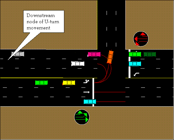
Figure 107. Illustration. U-turn example.
Continuous Left Turns (crossing an intersection)
Left turn lanes that extend across an intersection can be modeled in CORSIM. This provides storage for vehicles in spillback from the left turn. It also allows the model to position the vehicles for their upcoming turn. CORSIM permits assigning both a turn movement and a through movement to have the same downstream node. In Figure 108, the westbound approach link has two through lanes and a left-diagonal lane that all have the same downstream node. Using a left-diagonal movement has a couple advantages over using a left-turn movement. Vehicles making a left diagonal are not forced to slow down to the left turning speed as they discharge, therefore they do not cause delay on the link. Left diagonal movements also can be isolated from the other left-turn movement when assigning conditional turn movements. Therefore, 100 percent of the vehicles that enter the downstream link from a left-diagonal movement can be assigned a left-turn movement. Vehicles that enter the downstream link from a through movement must also be assigned as 100 percent traveling through and zero percent allowed to turn left. Otherwise, a percentage of the through vehicles will try to turn left.
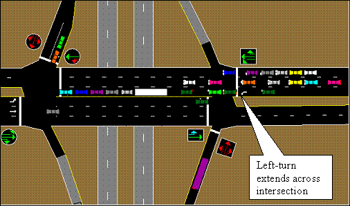
Figure 108. Illustration. Continuous left turn.
Two Intersections with Two Controllers Acting as One
When two intersections are in close proximity, as in a diamond interchange or an intersection with offset streets, the signals at both intersections are often controlled by a single controller. Although the actuated control model in CORSIM does not provide for this type of control explicitly, two controllers can be configured to emulate the control of both intersections by a single controller.
To model this type of operation, the “additional links” feature of the CORSIM actuated control model must be employed to specify detectors on streets that are not direct approaches to an intersection. Specifically, the detectors that are placed on the direct approaches to one intersection are duplicated on those same links, which serve as indirect approaches to the second intersection, and vice versa.
Furthermore, the same number of phases must be used for both intersections, and the same timing values must be specified for the identically numbered phases in each controller. However, the movements defined for the identically numbered phases in each intersection will be slightly different and will depend on the type of intersection and phasing being modeled. Although complex phasing schemes can be modeled using this approach, a simple example is provided to demonstrate this modeling technique.
Figure 109 illustrates a diamond interchange serving an east-west freeway. The movements on the north intersection that serve the westbound off-ramp traffic will be specified concurrent with the movements on the south intersection that serve the eastbound off-ramp traffic. Left turns on the streets between the intersections that allow traffic onto the freeway will be specified as protected and concurrent with each other. After the protected left turns are served, the north-south movements at both intersections are run concurrently and with permitted left turns. The actuated controller ring diagram is displayed for each intersection in the figure.
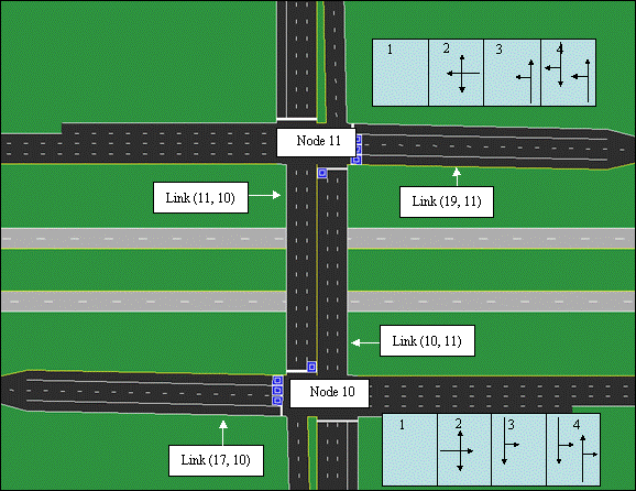
Figure 109. Illustration. Two controllers act as one controller to control two intersections.
North Intersection (Node11)
The phases for the north intersection are configured as illustrated in the ring diagram in the figure. Detectors are placed in the through and left-turn lanes of link (19, 11) and are configured to call phase 2. A detector is placed in the left-turn lane of link (10, 11) and is configured to call phase 3.
Links (11, 10) and (17, 10) are specified as additional (indirect) links to the intersection. A detector is placed in the left turn lane of indirect link (11, 10) and is configured to call phase 3 of the controller. Detectors, placed in the left and through lanes of link (17, 10), are configured to call phase 2 of the controller.
South Intersection (Node 10)
The phases for the south intersection are configured as illustrated in the ring diagram in the figure. Detectors are placed in the through and left-turn lanes of link (17, 10) and are configured to call phase 2. A detector is placed in the left-turn lane of link (11, 10) and is configured to call phase 3.
Links (10, 11) and (19, 11) are specified as additional (indirect) links to the intersection. A detector is placed in the left turn lane of indirect link (10, 11) and is configured to call phase 3 of the controller. Detectors, placed in the left and through lanes of link (19, 11), are configured to call phase 2 of the controller.
Finally, the timing parameters for the phases in the south intersection should be specified to be the same as the timing parameters for the corresponding phases in the north intersection. In the example, phase 4 in each intersection is placed on max recall because no detection was specified for that phase.
Mid-block Actuated Pedestrian Crosswalk
Using the pedestrian generator that is built into the actuated control functionality of CORSIM, it is possible to create a mid-block pedestrian crosswalk. Figure 110 shows a sample mid-block pedestrian crossing. No vehicle detectors are necessary. The main street phases should use recall in lieu of detectors. Calls to the controller are generated by the model to simulate a pedestrian pushing the pedestrian call button.
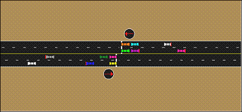
Figure 110. Illustration. Mid-block pedestrian actuated crossing.
CORSIM does not have the ability to simulate an exclusive pedestrian phase using the phase 9 method as provided by many controller manufacturers. However, in a limited number of situations where there are unused phases in the controller, the user may be able to employ one of those phases as an exclusive pedestrian phase. In this case, the user can place a node with actuated control at the location of the pedestrian crossing signal. The vehicle through movements can be coded as phase 1, and phase 2 can be coded as the exclusive pedestrian phase as shown in Figure 111. There are other possible configurations, but the user is cautioned to be careful when coding an unused phase as an exclusive pedestrian phase because the phase may be concurrent with a phase in the opposite ring.
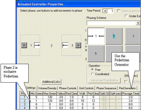
Figure 111. Illustration. Actuated control dialog for a mid-block pedestrian phase.
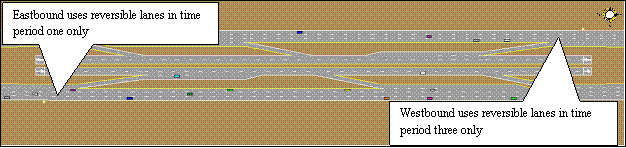
Reversible Freeway Lanes
In the real world, reversible lanes are the same lanes that vehicles travel on in both directions at different times of the day. In CORSIM, links can only be coded for a single direction, not bi-directional. In other words, vehicles cannot travel both directions on a link. In order to model a reversible freeway lane for express lanes or directional HOV lanes, each direction must be modeled separately using dummy freeway segments. By controlling the volume that enters the reversible lane in different time periods, it is possible to model reversible freeway lanes as shown in Figure 112. In this example, the analyst uses time period one to model the a.m. peak when the eastbound vehicles use the reversible lanes, time period two to model the off-peak period when no vehicles can access the reversible lanes, and time period three to model the p.m. peak when the westbound vehicles use the reversible lanes.
Alternatively, you can model the direction of flow in separate files, such as an a.m. period in one file and a p.m. period in a separate file. In this case, it is possible to overlap the reversible lanes and control which direction is visible by changing which links underpass the other links in the specific file.