Travel Time Messaging on Dynamic Message Signs - Portland, OR
Oregon Department of Transportation
May 2005
Table of Contents
1.0 Introduction
2.0 Deployment Information
3.0 System Planning and Development
4.0 Data Collection and Processing
5.0 Travel Time Messaging
6.0 Public Outreach and Impacts
7.0 Issues Faced and How They Were Resolved
8.0 Contacts
1.0 Introduction
The Oregon Department of Transportation (ODOT) Region 1 office is responsible for the operation and maintenance of Dynamic Message Signs (DMS) and the posting of travel time information to those signs on Portland area freeways. Supervision of such activities is conducted from its Regional Traffic Management and Operations Center (TMOC) located in downtown Portland.
ODOT began supplying travel time information to drivers via DMS in order to provide supplemental "customer service" benefits including: a) helping drivers make more educated decisions concerning route choice, b) reducing trip time related anxiety, and c) improving the public's perception of the usefulness of the DMS (e.g., the public is now provided with accurate travel time data instead of just a message stating "Congestion Ahead," or a blank sign).
2.0 Deployment Information
The advanced traffic management system (ATMS) software used in Portland is a customized version of Georgia's NaviGAtor software. ODOT currently uses its ATMS software to post travel time data to three of the 17 DMS deployed in the Portland metropolitan area. Plans exist to post travel time messages on additional DMS in the system as more loop detectors are deployed. Research is underway to determine the manner in which the system can most effectively be expanded.
Although there is always a trained operator on hand to monitor the system for disruptions, all travel time calculations and DMS travel time postings are automatic in nature. This minimizes the need for ODOT staff to devote time to ongoing system management.
Communications between sensor (loop detector) sites and ODOT's ATMS system are conducted via fiber or dedicated phone line. Communications between the ATMS system and the DMS have in the past been conducted over dial-up phone-line; however, ODOT is now transitioning to support these communications over a gigabit Ethernet system.
3.0 System Planning and Development
Prior to deploying their ATMS, ODOT participated in scanning tours for ATMS operations software in Los Angeles, Houston, and Atlanta. The Georgia DOT made their NaviGAtor ATMS software available for use/modification in the Portland area.
Selecting a target audience helped ODOT to determine the travel time destinations and messaging format to be used. Four potential target audiences for DMS messages were examined:
- Local commuter - people that live in the area and drive the same route on a daily basis to and from work.
- Local non-commuter - people that live in the area, but their trip purpose is non-work related. They may be local commuters during the peak hours but local non-commuters during other periods.
- Non-local commuter - people that do not live in the area, but are still on a work-based trip. They are probably not familiar with the local road network or typical congestion levels. Truckers would classify as non-local commuters.
- Non-local non-commuter - these trips are made by people that do not live in the area and are most likely on a recreational trip. These people are not familiar with the local road network or typical congestion levels.
Due to the fact that local commuters represent the majority of vehicles during weekday hours and that their travel is generally more time critical than that of other drivers, ODOT decided that they would be the primary target audience for the travel time system.
4.0 Data Collection and Processing
ODOT also determined that no firm rule existed concerning the number of sensors needed to provide accurate travel times along a particular segment of roadway. They decided that decisions on the location/number of sensors should be based on criteria that included the geography of the roadway and locations along the roadway where bottlenecks and other traffic problems occurred. Using this information, ODOT staff made engineering judgments concerning the number and location of sensors to be deployed, based corridor-specific conditions.
ODOT currently calculates travel times based on loop detector data (collected once every 20 seconds). One problem with ODOT's loop detectors is that many of them are located around ramps, thereby limiting the system's ability to detect congestion in certain areas. Additionally, ODOT has lost numerous loop detector stations during road repaving operations. The repaving operations required led to the travel time system being shut down for much of 2004.
The system is largely automated and operators generally rely on the software's failure management subsystem to notify them if a problem occurs (e.g., a drop in data accuracy). Even so, operators spot check data and have the ability to inspect travel time messages posted to all three DMS involved in the system using ODOT CCTVs. Plans are currently in the works to make modifications to ODOT's travel time software to ensure that it accurately calculates travel times when an entire data collection station ceases to function or loses the ability to transmit its data to the travel time server.
ODOT is currently working with TRIMET (local transit agency) to conduct a probe vehicle test using TRIMET buses (approximately 750 vehicles) on limited access and arterial roadways.
5.0 Travel Time Messaging
Based on research conducted during the project planning period, ODOT determined that the accuracy of travel time data posted onto the DMS should not drop below a threshold of 70 percent1. When the system was turned on, the accuracy during free flow conditions was over 95 percent, while the accuracy during periods of congestion was approximately 70 percent. Recently, ODOT has been collaborating with Portland State University to determine the current accuracy level of the travel time data produced by its system. The results of this study will be available by June 2005.
Due to the difficulty of accurately estimating travel times, especially during periods of congestion, ODOT decided to display travel time messages in two-minute ranges (i.e., "Travel Time 7-9 Minutes") during most times, and in up to four-minute ranges during periods of heavy congestion. ODOT decided to use the type of messaging format displayed in Figure 1 in cases where there were two destinations to be displayed on a particular DMS. A similar format exists for DMS that display a single destination. In order to help reduce overall driver distraction, DMS messages are single-phase only.
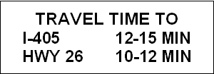
Figure 1 - Example of Travel Time Information Posted to ODOT DMS
ODOT developed guidelines for deciding which destinations to post travel times to for each DMS. The guidelines that ODOT developed are:
- At least 50 percent of drivers passing a DMS should go to or through the destination posted on the sign,
- The destination should be well known to a majority of drivers, and
- The destination should be within three to 15 miles from the DMS (travel times for destinations greater than 15 miles are difficult to predict).
These guidelines were used in the design phase to select specific travel time destinations for each DMS.
ODOT uses their DMS to post a variety of messages. Where provided, travel time messages are the default message. However, ODOT posts messages to DMS according to the following hierarchy:
- Road closures and emergency situations
- Incidents
- Construction and maintenance operations
- Adverse weather conditions
- Special events information
- Travel time information
- Public service announcements
ODOT's system is capable of posting travel time information to the DMS 24 hours per day, seven days per week. However, results of a survey conducted during 2002 indicated that drivers did not want travel time data during free flow conditions. As a result, ODOT posts travel times when conditions depart from free flow.
6.0 Public Outreach and Impacts
ODOT conducted a traveler information survey around the time of system start-up in 2001, but has not collected any new information due to budgetary restrictions. Even so, they continue to receive a significant number of comments about the travel time messages on DMS via their "Tripcheck" website. Other feedback is generally informal (from interested stakeholders); especially those involved in the Regional ITS Transportation Committee. Overall, ODOT received positive feedback about the travel time messaging.
When ODOT began posting travel time messages, they received a call from the Oregon State Police indicating that the DMS were causing traffic to back up as drivers slowed down to read them. In response, ODOT began a press campaign to inform drivers about the travel time messages. This demonstrated to ODOT the importance of public outreach and the solicitation of customer feedback, activities which continue today through their "Tripcheck" website.
7.0 Issues Faced and How They Were Resolved
| Issue | Resolution |
|---|---|
| Ensuring sufficient data quality | For the existing corridor where travel times are posted onto DMS, there is a high degree of confidence that the system is producing accurate forecasts. However, problems can occur when a particular sensor station isn't producing data. The system will still calculate travel times accurately when data comes from all stations (still works even if some loops at a station are missing). However, if an entire station is lost, the system doesn't account for it properly and provides shorter than actual travel times. As a result, ODOT wants to modify the travel time software to account for the loss of an entire station. |
| Inability to calculate travel times in certain areas | Don't yet have sufficient loop detector coverage to provide accurate data for posting on many DMS. ODOT is looking to use probe data from buses to provide additional data and otherwise expand the system. |
| Determining where sensor stations are to be located | No firm rule concerning how many sensors are needed along a give corridor. Looked at map to determine where bottlenecks and other traffic problems occur. Number and location of sensors depends on the conditions unique to each individual roadway - use engineering judgment based on corridor conditions. |
| Public awareness | Received calls from State Police stating that the DMS were causing traffic to back up as drivers slowed down to read them. In response, ODOT began a press campaign. It was also decided to use only single phase DMS messaging in order to reduce driver distraction. |
| Funding the system | Funding project through the STIP process - limited funding for capital construction. Have to compete with other activities for these resources. |
| Ongoing O&M | Ongoing issue - e.g., need to deal with impacts of road construction. |
Lessons Learned
- An automated system facilitates 24/7 monitoring of system operations. If problems occur, they can immediately be addressed from the TMC.
- It is advantageous to plan and deploy along one corridor at a time. This allows for the monitoring and validation of the existing system before taking it to other corridors.
- Plan for widespread detector deployment and data validation early in system planning.
- Ensure that data is provided in a manner that is useful/understandable to travelers (e.g., select destinations that are well known to the majority of drivers).
- Consider how travel time data might flow to other outlets (e.g., 511 telephone service or other public agencies).
8.0 Contacts
Dennis Mitchell, ODOT, dennis.j.mitchell@odot.state.or.us
Jack Marchant, ODOT, jack.w.marchant@odot.state.or.us
Galen McGill, ODOT, galen.e.mcgill@odot.state.or.us
Some of the information contained in the case study is taken from "Displaying Travel Times on Variable Message Signs: A Case Study in Portland, Oregon," by James Colyar, FHWA, May 2002.
1Kantowitz, B. H., Hanowski, R. J., and Kantowitz, S. C. (1995). "Driver Reactions to Unreliable Traffic Information," Proceedings of the ITE 65th Annual Meeting, pp. 673-676, Washington, DC: Institute of Transportation Engineers.
Federal Highway Administration
U.S. Department of Transportation
400 7th Street, S.W. (HOP)
Washington, DC 20590
Toll-Free "Help Line" 866-367-7487
www.ops.fhwa.dot.gov
Publication Number: FHWA-HOP-05-048