Travel Time Messaging on Dynamic Message Signs - Nashville, TN
Tennessee Department of Transportation
May 2005
Table of Contents
1.0 Introduction
2.0 Deployment Information
3.0 System Planning and Development
4.0 Data Collection and Processing
5.0 Travel Time Messaging
6.0 Public Outreach and Impacts
7.0 Issues Faced and How They Were Resolved
8.0 Contacts
1.0 Introduction
The Tennessee Department of Transportation's (TDOT) SmartWay is the official name for the state of Tennessee's intelligent transportation system (ITS). The SmartWay is focused on the application of advanced information technologies to improve the safety and operation of highways and other transportation modes. ITS deployments included within the scope of the SmartWay include: traffic cameras, roadway traffic sensors, and dynamic message signs (DMS). The TDOT SmartWay Traffic Management Center (TMC), which is responsible for the posting of travel time information to DMS, is housed in a new facility located on TDOT's Region Three campus in Nashville.
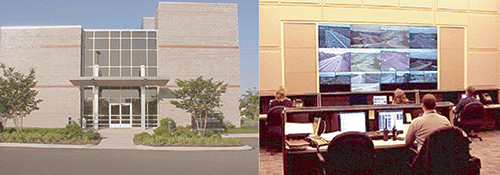
Figure 1 - The exterior/interior of TDOT's new TMC
Source: http://www.tdot.state.tn.us/tdotsmartway
(This link opens a new browser window)
2.0 Deployment Information
Travel time messages are currently displayed on two of the 20 fixed DMS managed by TDOT in the Nashville area. Travel time messages will be made available on two more DMS in October 2005. Travel time messages are controlled by MIST software (provided by PB Farradyne). All fixed DMS are NTCIP compliant and deployed on limited access roads. The TMC operates from 5:30 AM to 10:00 PM (M-F) and from 8 am-8 pm (Sat./Sun.). The TMC is staffed during peak hours by an operator, a supervisor, an operations manager, and a part-time operator.
Travel time messages are available on the two DMS at all times unless there is an incident that needs to be reported. RTMS (radar-based side fire speed sensors) detectors deployed at ¼ mile intervals are used to collect the raw speed data used by the travel time system to calculate travel times. A CCTV network is also deployed locally and used to support travel time verification.
The TDOT website provides a link to the SmartWay web page where images from the CCTV network and messages posted to the DMS can be viewed in real-time. The following are examples of the types of travel time messages posted to the DMS that can be seen on the SmartWay website. (see Figures 2a and 2b). These images are taken from the web page: http://www.cctv.tdot.state.tn.us/cctvnash/ (This link opens a new browser window).
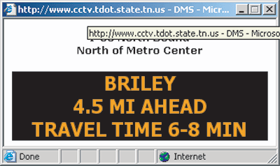
Figure 2a - DMS Sign showing Travel Time
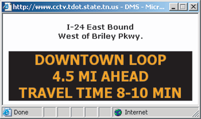
Figure 2b - DMS Sign showing Travel Time
As can be seen from the website, an extensive network of CCTVs and DMS are available to support expansion of the travel time messaging system (also see Figure 3, below). Blue icons represent cameras and gray shaded boxes represent DMS. As additional RTMS speed sensors are deployed, it is anticipated that more DMS will be included in the travel time messaging project.
3.0 System Planning and Development
TDOT initially became interested in the concept of posting travel times onto DMS during the design and implementation of the federally funded TDOT SmartWay ITS project. This broader ITS project included the design and installation of DMS, CCTV cameras, and speed sensors for traffic monitoring and incident detection. As TDOT was not interested in simply posting generic safety messages onto the DMS, they began investigating the feasibility of posting real-time travel times instead. TDOT staff toured Georgia's NaviGAtor facilities and became convinced that such a system could be implemented in Nashville. At that point, TDOT modified the requirements for their SmartWay TMC software to include the capability to estimate and post travel times to DMS.
While the overall SmartWay ITS project created an extensive network of DMS and CCTV cameras, the area covered by the RTMS speed sensors is limited. TDOT plans to install more RTMS units as part of their ongoing construction and improvement activities, which will enable providing travel time messages on outlying DMS.
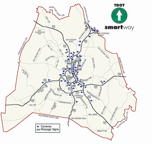
Figure 3 - System Deployment in Nashville
4.0 Data Collection and Processing
TDOT uses non-intrusive side-fire radar sensors installed at ¼ mile intervals to collect average speed data. The average speed data is used to generate travel times estimates. The TMC software automatically polls the speed sensors every two minutes. Travel times are calculated based on average speeds and distances between roadway sensors (from one RTMS sensor to the next). At present, travel times are displayed for only two destinations.
Travel times are automatically posted to the DMS by the TMC software. TDOT ensures data quality by regular calibration of the RTMS speed sensors. Another quality check is performed by TMC operators who use the CCTV network twice weekly to time a unique vehicle's passage through the portion of the network where speed/travel time data is collected. The vehicle's travel time is compared to the times generated by the system to ensure that the system is operating properly.
5.0 Travel Time Messaging
In addition to providing travel time to a given destination, the TDOT system also provides the distance to that destination from the DMS (see Figure 4). TDOT provides the travel time and distance to make the messages more understandable to out-of-town drivers. The TDOT system reports travel times to destinations that are no further than 5 miles from the DMS. Limited speed sensor coverage reduces the quality of travel time estimates for destinations further down the road.
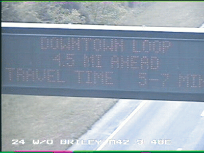
Figure 4 - DMS Sign showing Travel Time
Travel time estimates are provided in a 2-3 minute range (i.e., 6-8 minutes) as opposed to an exact travel time (see Figure 4) thus allowing for ± 1-1.5 minutes variation in travel times. Overall, travel time data is posted to the DMS about 80% of operational hours, excluding times when incident messages are posted. No safety messages are posted to the DMS.
The posting of incident information is of a higher priority than the posting of travel time information. During incident events, incident specific messages are used to indicate lane closures, delays, incident locations, etc. After an incident is cleared and the roadway has resumed normal operations, posting of travel time messages to the DMS resumes.
6.0 Public Outreach and Impacts
TDOT has received numerous emails and phone calls from road users who wish to express their happiness with the system. In addition, visitors to the TMC have indicated how useful travel time messages are to them. Although the system is still in its infancy, TDOT is eager to increase the number of DMS to which travel time information is posted. As the system expands, TDOT envisions developing DMS messaging-related press releases and conducting customer satisfaction surveys to solicit driver feedback.
7.0 Issues Faced and How They Were Resolved
| Issue | Resolution |
|---|---|
| DMS signs blank most of the time | TDOT did not like the idea of blank signs or generic safety messages. This was the driving force behind providing travel time messages on the DMS. |
| Data quality | TDOT ensures that speed sensors are calibrated often as the accuracy of speed estimates directly affects the travel time estimates. TDOT also verifies travel times by visually tracking vehicles via their CCTV network. TDOT also reports travel times in 2-3 minute ranges rather than a single number thus allowing for ± 1-1.5 minutes variation in travel times. |
| Hardware maintenance | The use of non-intrusive side-fire radar sensors (RTMS) has resulted in maintenance tasks becoming much easier than if traditional loops were used to collect speed data. |
| Data quality degradation over long segments | TDOT created a high density network of RTMS sensors with about 1/4 mile spacing. They report travel times for segments no longer than 5 miles. |
Lessons learned
- Posting of travel times to DMS is better than simply leaving them blank. Travelers react favorably to the information and management is supportive.
- Agencies should conduct an analysis of regional commuting patterns before selecting DMS locations for travel time messaging.
- Regular calibration of speed sensors is critical for accurate travel times.
8.0 Contacts
Ali Farangi, Tennessee DOT, 615-350-4189
Image Credits
Images are from the TDOT SmartWay Website, http://www.tdot.state.tn.us/tdotsmartway
Federal Highway Administration
U.S. Department of Transportation
400 7th Street, S.W. (HOP)
Washington, DC 20590
Toll-Free "Help Line" 866-367-7487
www.ops.fhwa.dot.gov
Publication Number: FHWA-HOP-05-050