Commuter Link - Salt Lake City, UT
FAST FACTS ABOUT: Commuter Link - Salt Lake City, UT
Types of TDM: Advanced Traveler Information Systems
Keywords: Real-time communication, multi-jurisdictional
coordination, technology, individualized demand management.
Area Demographics:
Salt Lake Area: 913,000 residents
Program: Technology allows SOV drivers to make better
choices by managing their own demand with real time travel information.
Cost of Program: In 2004 the reduced cost of server
technology makes this a much less expensive endeavor. Instead of requiring
nearly a dozen Unix Servers to capture/generate images and nearly 40
Intel web severs to operate CommuterLink, TOC employees intend to operate
all it with 3 or 4 more powerful Intel servers at an approximate cost
of $60,000. Implementer (s): Utah Department of Transportation (UDOT)
in partnership with Utah Transit Authority (UTA), Salt Lake City, Salt
Lake County, Wasatch Front Regional Council, Mountainland, Utah Department
of Public Safety (DPS), Federal Highway Administration (FHWA), Federal
Transit Administration (FTA), Federal Railroad Administration (FRA),
Salt Lake City Airport, ITS Rocky Mountain, ITA America, and Georgia
Navigator.
Contact: Troy Hyer –UDOT, Paul Jencks–UDOT,
Brian Chamberlain–UDOT.
Background Information
The CommuterLink system design was based on Navigator, the Georgia Department
of Transportation’s Intelligent Transportation System, which was
used for the 1996 Summer Olympics in Atlanta. With a deadline to have
the system operational by the 2002 Salt Lake City Winter Olympics, UDOT
staff felt it was better to go with an older model that had been tested
than to trouble shoot newer technology and deliver less than adequate
service to travelers during the Olympics. UDOT employees customized
Georgia’s software to address their needs and added the feature
that automatically disseminates alerts via email.
Advanced Traveler Information System Issues
Timing- Traffic reports on commercial radio stations are provided at
specified intervals of time. Most often, traffic reports are not broadcast
more frequently than every 10 minutes during peak rush hour. If an incident
is reported one minute after the last traffic report is given on that
station, it will be 9 minutes before commuters hear about it in the
next report. That interval of time is often when commuters initiate
their trip and make their decisions on which routes to take. Thousands
of commuters may have made different travel choices had they heard the
information. Instead they are choosing a route that will take them to
and contribute to worsening delays at the incident. Receiving the traffic
report as soon as the incident is reported gives commuters more opportunity
to avoid it and lessen impacts of it.
Simplicity- Radio stations often have to cater to their regional audience,
and therefore provide traffic reports on all of the roads in the region.
This is often rushed and confusing to listen to. If for some reason
you were distracted when they said something about your route, it will
be ten minutes before you can hear it again.
Solutions
UDOT recognized that in order to effectively manage traffic it is as
important to allow travelers to manage their own demand. This can be
done by providing travelers with information when and where they need
it. UDOT in partnership with numerous other organizations developed
CommuterLink as a centralized system to manage travel in the region.
Description of CommuterLink Website
In addition to traffic monitoring and incident detection, CommuterLink
also provides a user friendly format to relay the information detected
and monitored to the traveling public. This is done through the CommuterLink
Website. The CommuterLink Website (CLW) is operated by UDOT, on computer
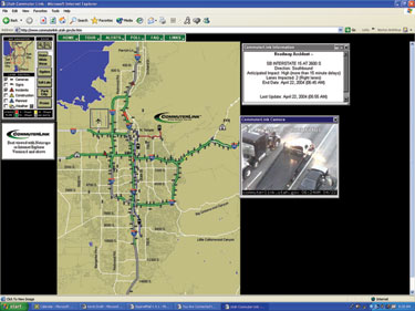
servers located at the TOC. CLW provides a map of the freeway system
and the major surface streets, where most of the surveillance equipment
is installed. CLW offers three primary types of information to the traveler:
1. Traffic conditions (speeds, incidents)
2. Roadway closures and construction
3. Weather (including pavement conditions)
Traffic information is presented in a number of ways. To display congestion
conditions, the speed on each freeway segment (about one-half mile long)
is shown as color-coded band (red = 0-30 mph, yellow = 31-50 mph, and
green = 51 mph and above). Incidents are denoted with a red triangle;
if the user clicks on that symbol, further information about that incident
is displayed on a small portion of the screen, in the lower left corner.
Visitors to CLW can also view video footage of real-time traffic conditions
by clicking on the cameras located on the map.
Roadway construction and closures are displayed as a color-coded triangle,
near the location involved. Yellow triangles denote current construction
and/or closures; blue triangles identify future construction or closures.
Weather conditions are displayed as a cloud near the roadway where road
conditions are provided.
Alert System
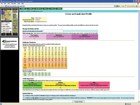
The CLW also enables individual users to subscribe to an “Alert”
system, which automatically sends an email message in the event of an
incident that falls within user-specified parameters (time of day, day
of week, severity of incident). CommuterLink provides information only
about the routes with a traffic impact level that concerns the subscriber
at a time when it concerns them. The criteria for which an individual
can subscribe can be seen at right.
When an “Alert Subscriber” presses the “Create Profile”
button they are added to the CommuterLink database. Every half hour
subscribers who checked that “Notification Timeframe” box
are activated. Within that half hour, CommuterLink captures information
about travel speed on regional roadways every 20 seconds. If travel
speed on any of those roadways indicates an incident, CommuterLink sends
an email is sent to the subscriber. A sample message would be, “Crash
I-15 at 1500N SPGVL on right shld.”
A variation on receiving this information is an email account allows
users to receive this information on their cell phone or pager using
text messaging. This provides them with the information they need, when
they need it, wherever they may be.
By receiving emails at work before they leave to get in their car, commuters
can make a decision to delay their departure until incident is cleared
or plan an alternative route to avoid the incident. In either case the
traveler is not adding to the problem created by the incident and able
to use their time more productively. Similarly, by having the information
sent to their pager or cell phone, commuters can receive information
about an incident before they leave the office or while they are on
the road. If they receive it early enough they can receive the same
benefits listed above.
Quick Facts*
• CommuterLink initiated email subscriptions in late 2000.
• In March 2004, CommuterLink had 6,652 commuters subscribing
for traffic incident information to be sent to their email account.
• CommuterLink had 121,117 visitor sessions during March of 2004.
Averaging 3,907 sessions per day.
• 83% of the sessions occur during the week with Monday and Wednesday
being the busiest days
• CommuterLink receives its most visitor sessions between 7:00
am and 6:00 pm. Peak usage is be- tween at 4:00 pm and 5:00 pm for commuters
to plan their trip home.
___
*Detailed usage statistics for the CommuterLink Website are maintained
by the website host (UDOT), using the “Webtrends” tracking
software package. All usage data reported in this section are based
upon the information reported by that system.