 |
MANAGING DEMAND THROUGH TRAVEL INFORMATION SERVICESU.S. Department of Transportation |
The Federal Highway Administration (FHWA) provides high-quality information to serve Government, industry, and the public in a manner that promotes public understanding. Standards and policies are used to ensure and maximize the quality, objectivity, utility, and integrity of its information. FHWA periodically reviews quality issues and adjusts its programs and processes to ensure continuous quality improvement.
|
Note From The Director Information can influence transportation decisions in some very clear ways – time choices, mode choices, path (i.e., route) choices, and location choices. With better ways to learn how emergencies and other incidents affect travel times, workers can start for work and return home at times more responsive to actual traffic patterns than a fixed schedule. Better information can also influence the choice of the path to work or other destinations, specifically for private vehicles. As the effects of congestion become clearer to people, they are more able to consider alternate paths to their destination. In this light, the Federal Highway Administration is pleased to present this brochure entitled Managing Demand Through Travel Information Services. It highlights the opportunities and benefits for using traveler information services to manage demand during periods of congestion, including congestion during commute periods, special events, and emergencies. The brochure aims to provide ideas for the use of traveler information in states, regions, and communities. The brochure presents the diversity of traveler information systems employed around the country and overseas and how agencies are using traveler information as a demand management tool. The results are summarized in an easy-to-read format. In the following pages you will find:
We believe that travel information systems can have a profound effect on managing the demand for transportation facilities and services. When applied as a demand management tool, it can help to improve the performance of the transportation system by facilitating the movement of people and the delivery of freight. With the help of our partners throughout the transportation community, the Federal Highway Administration looks forward to working with organizations, agencies, and interest groups to further advance the ideas and practices presented in this brochure.  Jeffrey Lindley |
Traveler information has exploded over the past decade with the development and use of advanced technologies able to detect, analyze, and disseminate traffic and transit conditions. The traditional information mainstays of radio and TV traffic broadcasts are now being supplemented in many places with travel websites, real-time roadside and "next-bus" displays, e-mail and personal digital assistant (PDA) alerts, and 511 phone systems, to name a few. Detailed and up-to-the-minute information is changing when, where, and how we travel.
Traveler information is transforming the way transportation professionals can manage travel demand. In the past, managing demand meant switching commuters, long term, from driving alone to carpooling, transit, or having them avoid the commute altogether by telecommuting. Today, travel management strategies have broadened to include influencing the timing, destination, and route of a trip, not just the choice of transportation mode. Such changes are much more likely to be short-term, spur-of-the- moment decisions made just before a trip takes place or even en-route.
Traveler information is also much more than helping commuters navigate rush hour. Of course, managing commuter travel is still a major concern in most metropolitan areas. But, managing travel for local and long distance trips taken for social and recreational purposes, around planned special events, in poor weather, in emergency situations, and in rural areas is also important. Freight transportation is another part of the mix, particularly in certain travel corridors and near border crossings, ports, and big manufacturing and distribution facilities.
This brochure highlights the exciting potential of advanced traveler information systems (where information is delivered electronically) with examples from around the country and overseas. It is for anyone involved in passenger and freight mobility, particularly transportation policymakers, planners, and managers in state and local government. The brochure is organized in the following way:
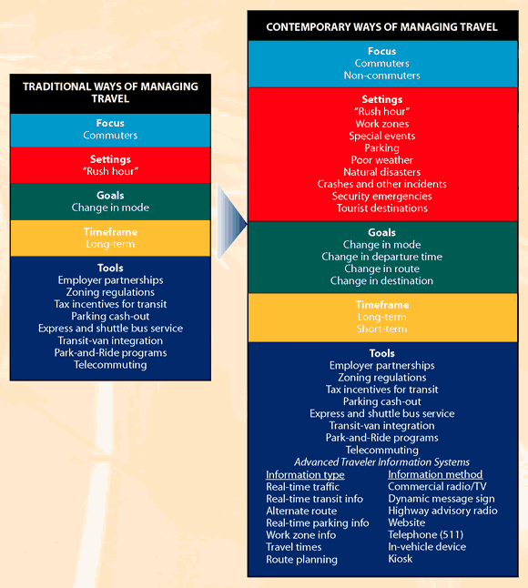
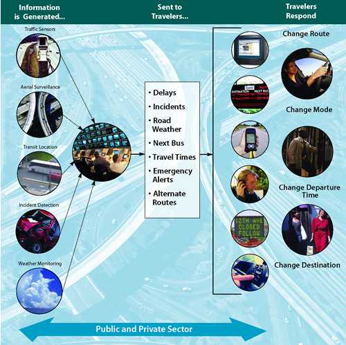
Traveler information is any trip-related information provided to a traveler or potential traveler. Information can include traffic conditions, the availability and conditions of public transportation, and the availability of parking, to name just a few. In its broadest sense, traveler information may include traditional road signage and maps; but, the focus here is on information produced by advanced traveler information systems.
Advanced traveler information systems use technologies that assemble and process travel-related data and disseminate useful information to travelers. These technologies include sensors for monitoring travel conditions, communications for sending and receiving information, data processing, geo-location technologies, microprocessors, and other technological advances that are fueling the rapid growth of traveler information systems in the United States and elsewhere.
Traveler information systems in operation today are not all alike. A system may cover a single metropolitan area, an entire state, or an even larger area such as a multi-state corridor. The types of information and the modes covered can also vary widely. A system might use data from a single transportation entity, such as a state department of transportation (DOT) or a metropolitan transit operator, or it might span multiple modes of travel with data from several agencies and also private entities.
Data for use in a traveler information system are often collected for other purposes, such as monitoring freeways for vehicular crashes or other incidents, identifying buses or trains that are behind schedule, or determining when snowplows should be deployed. These data have a valuable second use when they are processed and packaged in forms that can be used to influence travelers' trip-making decisions. These days, both public agencies and private organizations are providing information to travelers in many ways and technological advances keep expanding travelers' options on how information can be obtained: telephone, Internet, radio, TV, variable message signs, PDAs, and more.
Traveler information systems are available in one form or another in practically every part of the United States. Websites enable operators of bus, rail, and ferry systems to communicate schedule and fare information not only to local residents but to visitors planning trips to an area. Dynamic message signs (DMS) enable highway agencies to tell drivers about problems ahead. A recent innovation is 511, a three-digit telephone number that the Federal Communications Commission (FCC) designated exclusively for traveler information in 2000. Intended as an easy-to-use, ubiquitous service, 511 was available in 25 locations by the fall of 2004 and more are on the way.
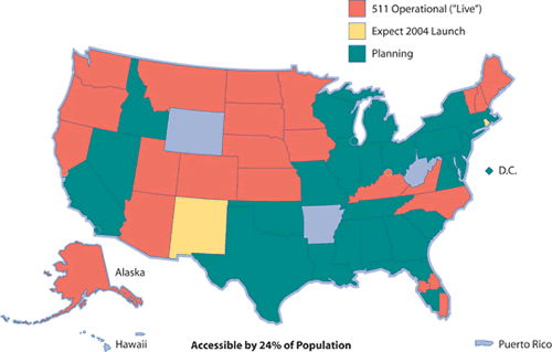
511 Deployment Status
as of November 2004
Travelers want accurate, timely, and reliable information in a form that is convenient to use. For example, camera views of traffic conditions on the Internet are popular features of traveler information websites, as is travel time information that tells a traveler how long it will take between specific origins and destinations. For transit customers, knowing the location of buses and trains, times of departure or arrival, and operational problems is highly valued. For telephone-based services, such as 511, users want to be able to access their specific route information rapidly and get details on problems.
Traveler information will need to be free to the traveler in most cases. Although market research has sometimes suggested that travelers may be willing to pay for information, commercial services have not had much success in charging customers for traveler information. Travelers appear to view traveler information as a service that agencies should be providing or, in the case of commercial radio and television, should be underwritten through other means, such as advertising.
Customers have demonstrated that they benefit from traveler information services, and well-designed traveler information systems receive a positive reception from the traveling public.
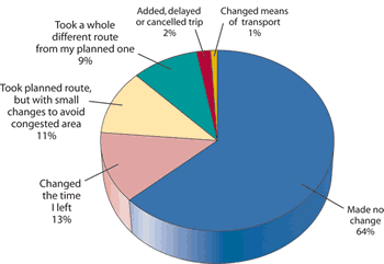
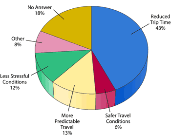
As illustrated by travelers in Seattle, benefits from traveler information include avoiding congestion, reducing uncertainty and stress, saving time, and improving travel safety. These benefits are the direct effect of providing travelers with choices about the time, route, mode, and destination of travel. While helping individual travelers, traveler information can have system-wide benefits at the same time, when many travelers respond to the information they receive. Thus, traveler information can be an important operational tool for agencies to manage the safety and level of service of their facilities.
Effect of Traveler Information on Travel
Benefits of Traveler Information
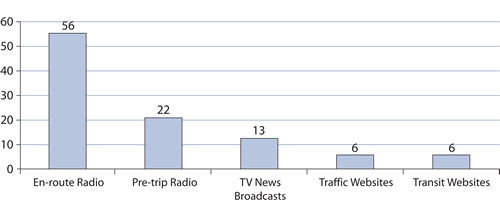
Top Sources of Traveler Information
(percent of trips where information consulted)
Example: Multimodal Traveler Information Systems in the Seattle RegionThe Seattle region provides multimodal traveler information to commuters by the Internet and phone. Washington State Department of Transportation's (WSDOT's) award-winning website, www.wsdot.wa.gov/traffic, serves as a model for presentation of traffic information to commuters and other travelers. Comprehensive traveler information for the entire state is available on its website, including the Seattle area. Highlights include:
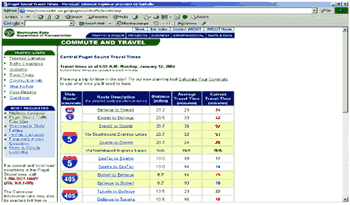 Central Puget Sound Travel Times The WSDOT's 511 telephone service was launched in 2003. Its features include:
Transit and rideshare information is presented online through the King County Metro website at tripplanner.metrokc.gov. Highlights include:
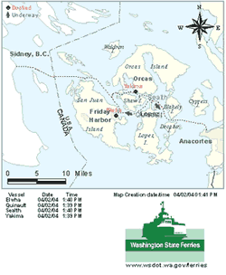 Vessel Watch: Real-Time Ferry Tracking System Washington State Ferries' website, www.wsdot.wa.gov/ferries, includes:
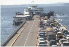 Ferry Terminal Camera |
The workday commute regularly places enormous strain on the transportation system. Traveler information systems are able to help in several different ways, including:
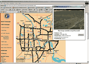
Traveler Information Website in Minneapolis/St. Paul
Courtesy Minnesota Department of Transportation
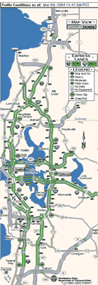
Traveler Information Website in Seattle
Courtesy Washington State Department of Transportation
Gains from managing commuter traffic are not limited to mobility improvements. Managing travel may also improve air quality, safety, and aesthetics by reducing the number and density of vehicles in the journey to and from work.
When commuters are made aware of congestion or other problems on their typical routes through traveler information, studies show they will often decide to modify their work trip. The type of change they make depends on when information is received (pre-trip or en-route) and the technology available to a traveler for accessing the information.
Traffic Websites Important for the Commute Trip. Almost every state DOT and many traffic departments of major cities have real-time traffic webpages that provide up-to-the-minute information on traffic conditions such as speeds, levels of congestion, camera views of roads, incidents, and other pertinent information before the commuter starts out. In addition, there are many private companies that provide websites with additional traffic information collected through their own sources (helicopters, sensors, roving vehicles, etc).
Employee surveys in Seattle and Los Angeles reveal that a majority of workers report use of the Internet to obtain traffic information for their commute trips. Commuters tended to use information on the Internet more heavily during the afternoon commute rather than the morning commute because they have greater flexibility in leaving work based on traffic conditions. Even more reported that they used web-based traffic information to decide between different routes.
Commuters are no longer restricted to accessing traveler information websites from their home or office. With cell phones and PDAs that have wireless Internet access, technology-savvy commuters can check for traffic and transit conditions at any point during their commute and make adjustments as needed. For example, Houston commuters using TranStar can display travel time and incident information on cell phones, and in Denver bus riders can connect their cell phones to the Regional Transit District (RTD) webpage to obtain the arrival time of the next bus on a specified route.
511 Boosts Telephone Information Services. The telephone as a medium for delivering information to help commuters has been used for many years, but it got a big boost in July 2000 when the FCC designated 511 as the national travel information number. The first 511 service was launched less than a year later. In the fall of 2004, 511 was available to 24.2 percent of Americans, and 23 million calls had been placed to 511 in just three years. More systems are on the way. While many of the systems offer statewide information, 511 services aimed at metropolitan commuters are available in the San Francisco Bay Area, southeast Florida, Orlando, Tampa, Sacramento, and Cincinnati/northern Kentucky regions and are expected to be launched in other cities in the near future.
Available to commuters over a landline phone or cell phone, a call to 511 uses voice recognition or touch tone to select information such as traffic incidents and construction, transit schedules and major delays, and weather-related travel conditions. Surveys of 511 users reveal a high level of satisfaction with the service and willingness to use it again.
E-mail Alerts for Commuters. An increasing number of transportation agencies are offering alerts to their customers on a subscription basis. Commuters can select specific routes for which they want to receive e-mail alerts sent to a PDA, mobile phone, or an Internet account. In Utah, the CommuterLink website (www.commuterlink.utah.gov) provides e-mail alerts on traffic conditions, construction projects, or weather information to subscribers, who can specify the impact of the alerts (high, medium, or low) for their selected route. The advantage of alert services is that the commuter doesn't have to actively seek traveler information because it is automatically sent to the subscriber, who in turn can decide to change the route or timing of a trip to avoid problem areas.
The Old Standby – Commercial Radio and TV. One of the oldest and most common sources used by travelers to obtain information for their commute is commercial radio and TV, which provides periodic quick snapshot reports of travel conditions. These sources of traveler information come to mind first when commuters plan their trip ahead of time or when they are en-route. In a Minnesota survey, general radio and regular TV were used by over 77 percent of travelers, and most of them are interested in "exception reports" about their usual journey. One shortcoming of these services is that the brief time allocated for reports by TV or radio stations may not be sufficient to provide the geographic coverage or level of detail that commuters are seeking. Nevertheless, their ubiquity and ease of access makes TV and radio the most common source of information for many commuters.
Cable TV Dedicated to Traveler Information. Breaking out of the constraints of commercial broadcast TV, traveler information is available in some locations over dedicated cable TV channels. The government of Montgomery County, Maryland, offers live traffic reports on a local cable channel each weekday during the morning and afternoon rush hours to inform commuters of local roadway conditions. Information provided to travelers includes a streaming loop of traffic cameras on major roadways in the region and is accompanied by a radio broadcast that provides delays, incidents, and other information including telephone numbers for transit information. During storms or emergencies, the local cable operator works with the County's traffic management center to provide quick, accurate information on road conditions, school closings, bus or rail delays, or program cancellations.
As part of a federally funded project in Arizona, a dedicated channel known as Traffic Check began airing in Tempe in 1998 and was later expanded to include Mesa as well. Traffic information broadcasts are provided continuously during the morning and afternoon rush hours. Broadcasts are fully automated and typically repeated every 5 to 8 minutes, depending on the number of incidents to report. In unusual cases, a single cycle of the program can last up to 15 minutes.
Dedicated Cable TV Channel, Montgomery County, Maryland
Courtesy Department of Public Works and Transportation, Montgomery County, Maryland
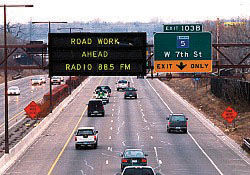
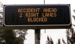
Travel Time Information on DMS. Even though DMS are used mainly to report critical information on road closures, incidents, and other non-predictable situations, a few transportation agencies have begun to develop travel time information and use the signs to display it when no other critical information takes priority.
Most transportation agencies that display travel time information have an automated algorithm that calculates the distance and the speed from sensors and provides travel times for specific corridors and/or landmarks. Commuters can decide if an alternate route should be taken based on the travel time displayed or, at the very least, the information helps remove the uncertainty or worry about how long a trip might take.
In France, DMS have been installed at 204 locations on the Paris ring freeway, its ramps, and the inner city ring freeway. Up-to-the-minute travel time is calculated with data from a network of 680 sensors that monitor traffic flow. Drivers find the real-time travel time information much more useful than general messages such as "congestion ahead."

DMS Used to Display Travel Time
DMS image, © 2004 Texas Department of Transportation
With three-quarters of workers driving alone to work, a key travel management objective is to entice commuters to take transit. Transit agencies use traveler information to make transit more user-friendly so that commuters consider transit a viable alternative to their own vehicle. The Internet, telephone information services, and e-mail alerts are some of the approaches being used by transit agencies to assist their current or potential passengers.
Transit Web-based Information Becomes Commuter Tool. Transit commuters in many parts of the country can now easily obtain detailed information on schedules, maps, itinerary planning, and real-time location of their buses and trains over the Internet. With the growth of Internet access nationwide, usage of transit information web- sites has risen dramatically. On some transit websites users can tailor the information to their needs. King County Metro in Seattle, Washington, has a unique feature on its web- site called "BusView," which allows the transit customer to track the progress of a specific bus on its route and set an "alarm" for notification when their bus passes a particular point along their route. In Denver and Portland, agency websites let transit riders get real-time arrival information for the next two buses based on the rider's input on the route, direction, and stops. Go Transit in Toronto introduced a new feature called "Today's Service Updates" in response to customer comments. Customer response to this feature has been very positive, and their website usage increased from 3,500 to 6,500 visits per day.
Automated itinerary planning is another advanced feature available on some transit websites, such as RideGuide in Washington, DC (www.wmata.com). The transit user enters a number of variables (origin, destination, time of travel, etc.), and the system provides the user with step-by-step instructions on the best routes, fares, maps and detailed instructions on the complete trip. RideGuide's popularity is clear from the two million completed itineraries per year on the web.
Traveler information tools such as these can help boost transit ridership. For example, 70 percent of respondents to a survey of California's GoVentura website trip planning system said the website helped them make a transit trip that they would otherwise have made by automobile.
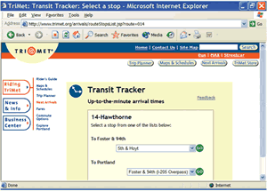
Traveler Information for Transit Riders in Portland, Oregon
© 2004 TriMet, Oregon
Transit Information Phone Systems Become More Sophisticated. Telephone information systems, staffed by human operators, have been a principal means by which commuters obtain information for most transit systems. Of surveyed users in Washington, DC, 82 percent took the trip they had called about and would not have done so without having received the information. The Washington Metropolitan Area Transit Authority found that the principal users of its phone system were transit riders of choice rather than necessity. Still, cost of staffing telephone systems with live operators has led many agencies to look for some form of automation, which can also provide innovations that increase the value of telephone information systems to transit customers.
One example of an automated telephone information system is the "560 system" in Ottawa-Carleton, Canada. Users of its system can call a telephone number for a specific stop or station, which has been assigned a 560 prefix, and obtain arrival times of the next two buses at a specific stop. They are also notified about any delays or other problems along the bus route. Comparison of routes with and without the 560 system showed a positive impact in peak period and an 8 percent increase in off-peak ridership.
E-mail Alerts Deliver Information to the Transit Customer. Another feature that is being offered by transit agencies for their commuters is an e-mail alert system with real-time alerts on a commuter's specific routes sent to a PDA, mobile phone, or to an Internet account. The customers need to sign up for the service and provide basic information on the types of information they want. The Washington State Ferries has 8,600 customers registered for e-mail notification and about half of these customers are commuters. Agency staff enter service disruption or other information, and notification is e-mailed to everyone in the subscriber database. E-mails are sent when a vessel is delayed 20 minutes or more for a major mechanical problem, when a run is cancelled, or when handicap accessibility problems occur.
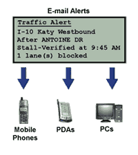
Houston TransStar's E-Mail Alert Service
© 2004 Texas Department of Transportation
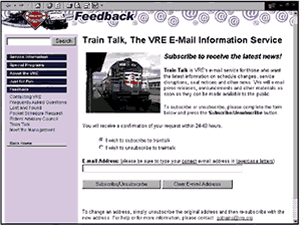
Virginia Railway Express' E-Mail Alert Service
Courtesy Virginia Railway Express, Virginia
The Virginia Railway Express provides the Train Talk e-mail news service for its customers. Approximately once per week, the agency sends out an e-mail to all subscribers that contains important service information. Train Talk is targeted at customers who want the latest information on schedule changes, service disruptions, seat notices, and other news.
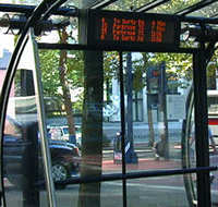
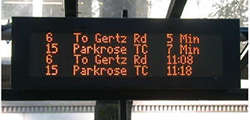
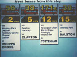
Real-time Transit Information En-Route. Automatic vehicle location systems that track buses and trains are being used to provide accurate information on arrival times to customers. This information is either presented at the bus stop or rail station through DMS or through devices that are capable of receiving wireless data, such as PDAs and cell phones. Denver RTD provides next bus arrival information to their customers through PDAs and cell phones. The Portland TriMet and the San Francisco MUNI have signs that display real-time information on routes and time of next arrival. London (England) Transport's Countdown signs list the order in which buses will reach their stop, their destinations, and the number of minutes to arrival. About two-thirds of these bus riders reported shorter wait times and nearly all felt the signs made waiting times more acceptable.
DMS for Transit Users in Portland, Oregon
Courtesy Mala Raman, Battelle
DMS for Transit Users in Portland, Oregon
Courtesy Mala Raman, Battelle
DMS for Transit Users in London
Courtesy Carol Schweiger, TranSystems
A traditional way of managing travel is to enhance the carrying capacity of the road system by encouraging commuters to carpool, and traveler information can help here too. Carpoolers and bus riders report significant time savings when HOV lanes are available. To promote ridesharing, information is increasingly available online for easier access. Online information encompasses rideshare programs, vanpool seats and routes, HOV lanes, employee-based programs, and park-and-ride lots for the commuter. In Canada, Calgary's Commuter Connections rideshare program grew from 349 carpools in November 2002 to 1,420 carpools in February 2004, and a third of participants formed carpools through the program's website, www.carpool.ca. In northern Virginia, Virginia DOT offers commuters an online method to calculate the time saved by using an HOV lane based on pre-selected origins and destinations.
Example: TravInfo™ in the San Francisco Bay AreaThe San Francisco Bay Area uses a wide variety of strategies for managing travel, and traveler information plays a central role. TravInfo is the regional traveler information system; and its goal is to broadly disseminate accurate, comprehensive, timely, and reliable information on traffic conditions and multi-modal travel options to the public. TravInfo has been providing information through a 511 telephone service and a co-branded website, www.511.org, since 2002. Managed by a partnership of public agencies led by the Metropolitan Transportation Commission, the California Highway Patrol (CHP), and the California DOT, 511 is a toll-free phone and Internet service that consolidates Bay Area transportation-related information into a one-stop resource and provides the following information: 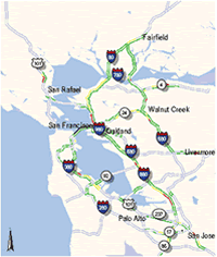 Bay Area Traveler Web Pages: Driving Time Map  Bay Area Traveler Web Pages: Bicycle Route Map Traffic
Transit
Rideshare – Carpooling and Vanpooling
Bicycling
A customer satisfaction survey of Bay Area 511 phone users in 2004 found the following:
|
In other predictable settings besides commuting, information can help travelers manage trip timing, route, mode, and destination. These settings include highway construction work zones, planned special events, tourist areas, and places where the demand for parking is high (such as downtowns and airports). Operators of the transportation system usually know when and where problems are likely to occur and, as a result, can plan informational strategies to maintain and enhance mobility.
Example: AWIS Deployment in Central ArkansasAutomated work zone information systems (AWIS) have been deployed in central Arkansas by the Arkansas State Highway and Transportation Department (AHTD) in and around several major construction and rehabilitation projects on Interstates I-30 and I-40 near Little Rock. These projects were started in 2000 and are expected to be completed in 2005. In mid-2004, three AWIS were operational on I-30 and I-40. 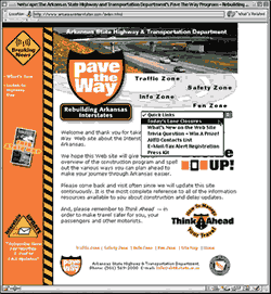 AHTD's Pave the Way Website The AWIS installation and maintenance in Arkansas are contracted out to a private company that owns and operates the equipment. The AWIS equipment being used includes remote traffic microwave sensors, radio transmitters, DMS, and stationary video cameras mounted on trailers. The data collected by the sensors and cameras are processed automatically to identify traffic conditions, such as locations and severity of slowing or stopped vehicles. Information is then relayed back to motorists via DMS, highway advisory radio (HAR) stations, and the AHTD website. The AWIS is set up to identify nine levels of severity that warrant communication with travelers. The nine alert levels are triggered on speed, volume, and occupancy levels detected by the sensors. A simplification of the alert levels is provided in the table based on speeds. When significant delays are detected, flashing beacons on HAR alert signs advise motorists entering the broadcast area to tune in with "urgent when flashing, tune to 1490 AM." If both lanes are closed, travelers are advised to use alternate routes. While the roadside message boards and radios require a 5-minute relay time, sensor-recorded traffic speeds are transmitted instantaneously to the AHTD website, www.ArkansasInterstates.com. Website visitors see a complete view of work zone traffic conditions with color-coded roadway segments indicating whether traffic is flowing, slowed, or stopped. Hovering the mouse over any of the equipment icons will call up a live video image or display the text and audio messages motorists are receiving out on the road. An evaluation of a central Arkansas AWIS on I-40 determined that people are willing to change routes when warned of congestion caused by a work zone. Truckers were much more likely to take an alternative route than travelers as a whole.
Messages Used by Arkansas AWIS |
Work zones are a renowned source of travel delay and are expected to increase in fre- quency and duration as traffic grows and our infrastructure ages. Despite the success of a wide range of new contracting and construction techniques aimed at minimizing the effects of work zones, operational strategies are also easing the way through traffic zones. In particular, AWIS are now being deployed around the country to manage demand in and around construction areas.
AWIS typically gather real-time traffic information in work zones using radar sensors and video cameras located along the roadway. These data are used to determine, automatically or by operations personnel, traffic speeds, backup locations, and queue lengths, as well as the location of incidents causing traffic to slow or stop. Together with other data such as work zone schedules, information is then provided to travelers about road/lane closures, times of construction, travel time through work zones, incident information and warnings, and detour information. Work zone information can be communicated by various means including DMS, HAR stations, 511 systems, and the Internet. Travelers can use the information to determine if their travel needs to be modified.
Sporting contests, concerts, holiday parades, and other planned special events can attract large numbers of people, placing enormous strain on the transportation system. Although not an everyday occurrence, planned special events happen with great regularity and at a time and place known well in advance.
Information Needed for Special Event Travel ManagementInformation for Both Event Goers and Other Travelers
Information for Event Goers
Information for Other Travelers
|
Techniques for managing travel during planned special events have to be tailored to both event goers and other travelers. The goals are to encourage event patrons to use travel modes other than personal automobiles, to encourage a shift in arrival and departure times to reduce peak traffic volumes, and to increase vehicle occupancy. For other travelers, the goals are to divert non-attendee travelers, around the affected area and to alter non-attendee time of travel to avoid conflict with the beginning and end of the event. While both groups can benefit from up-to-the-minute traffic information, event goers are most interested in how to reach and leave the event area. Other travelers need to know how best to avoid event traffic, if possible.
Special event information is disseminated by Internet, 511, DMS, HAR, TV, radio, and kiosks. Utah DOT's CommuterLink website (www.commuterlink.utah.gov), for instance, provided a wealth of pre-trip information during the 2002 Winter Olympics in Salt Lake City, Utah. Both visitors and residents used CommuterLink to obtain traffic information, road conditions, Olympics information (e.g., travel options and event operations information), and weather information.
Example: Kansas Speedway, Kansas City, KansasDMS and HAR have been used by the Kansas Highway Patrol and the Kansas DOT to manage events at the 75,000-seat Kansas Speedway located off Interstates 70 and 435 on the west side of Kansas City. For three major events in 2001, traveler information technology was used in conjunction with standard traffic control items such as cones, barrels, and signs. The traveler information consisted of three "Smart Zones" that integrate DMS, detection devices, and surveillance cameras on one fully portable, solar-powered platform as well as 12 portable DMS and four HAR transmitters. The Smart Zone communicates using 2.4 GHz spread spectrum radio, allowing full-motion video. From live traffic images and complementary detection data, operators in a central command post send updated traffic information to motorists in real-time. The effectiveness of "Smart Zones" became clear in the first season. During the first race weekend in June 2001, with approximately 45,000 fans, no significant delays entering the facility due to traffic congestion were reported. During the second event of the season in July, no significant delays due to ingress and egress of vehicles were reported. The video cameras were used effectively to monitor back-ups and divert traffic on a real-time basis by sending messages to the portable DMS informing drivers of alternate routes and by radioing troopers in the field informing them when and where to divert traffic. At the third event of the season, the NASCAR weekend, traffic was expected to be at its highest levels and to suffer significant delays. With over an hour before the race started, all roadways leading into the Kansas Speedway were at free-flow conditions. After the race, which is considered the worst period for traffic congestion at race facilities, the roadways leading away from the track were at free-flow condition in a record 1.5 hours. 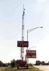 Portable Traveler Information System Used Near the Kansas Speedway |
Tourist destinations typically experience heavy traffic volumes for just a few months a year. If the location is predominantly rural, like many beaches and ski resorts, the transportation infrastructure is usually ill-equipped to deal with the crush, causing problems for residents and visitors alike. For urban areas with large numbers of tourists, like Washington, DC, visitors add another dimension to the travel problems associated with commuting and planned special events.
Traveler information can be very effective as a tool for managing travel in tourist locations during the peak season. Traveler information plays an important role due in part to the relative unfamiliarity of the travelers with the area. Information on tourist attractions, road construction, traffic conditions, transit schedules, parking, weather conditions, and lodging options are all extremely useful to tourists. In addition to the usual methods of information dissemination, staffed information stations are an option in this type of environment. A wide range of traveler information for visitors to Cape Cod, Massachusetts, is available on a website, www.gocapecod.org. In the Shenandoah Valley, Virginia traveler information for tourists is available on the 511 telephone system and on a website (www.511virginia.org).
Example: Acadia National Park, MaineAcadia National Park, located on the coast of Maine, is open year-round; but, it is one of the most visited National Parks in the summer season. The rough terrain and goal of protecting the natural wonders of Acadia severely limit the Park's ability to accommodate travel demand. To help manage the demand, the Acadia National Park, in cooperation with Maine DOT and other local organizations, has tested traveler information in the form of real-time bus departure signs and on-board bus announcements and real-time parking information on message boards. Both bus information systems aimed at having visitors use the free bus system called Island Explorer, while the parking information also sought to alter which part of the Park people visit and when. Information about the buses and parking were also available on a website. 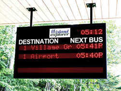 Traveler Information in Acadia National Park In a survey of visitors in 2002, more than two-thirds said the electronic departure signs and on-board announcements helped them decide to use the Island Explorer bus. And almost half of the users of the real-time parking information said it helped them decide to use the Island Explorer bus. Traveler information technologies have contributed to the overall goal of diverting visitors from personal vehicles to using the transit. The real-time parking information enhanced visitor mobility by avoidance of parking problems and traffic congestion. More than one-third of park visitors who used the signs changed the time they visited a destination, and another third changed destinations based on the information. The parking lot information was considered instrumental in reducing excess parking at two of the most popular destinations in the Park—Sand Beach and Jordan Pond—thereby shifting demand to other modes and to other destinations. |
Parking management systems can pay enormous dividends for travelers in time saved and reduced frustration and anxiety. They may also help manage travel demand because in many situations, particularly dense urban areas, during planned special events, and in tourist areas (see the Acadia National Park example above), the search for parking often keeps vehicles on the road needlessly and may cause lengthy queues that block adjacent streets. Safety is also an issue with slowing and stopped vehicles in travel lanes.
Information in the form of real-time parking availability, parking maps and prices, and shuttle schedules can help distribute traffic among the various available options. Parking information can be provided pre-trip through the Internet. However, a more common method of dissemination is through DMS that allow travelers to make a decision en-route. Parking information systems are still in their infancy in the United States, but Europe has more mature systems, where they are typically part of larger efforts to promote and preserve the economic viability of city centers and enhance information on all modes of travel into the city.
In the case of a "full" or nearly full parking situation, some systems give messages advising drivers to use transit with directions to the nearest park-and-ride lot. As drivers get closer to downtown and approach "decision points," where they can choose among routes to various parking facilities, they encounter DMS displaying real-time numbers of available spaces in two or more garages or lots. For example, in Cologne, Germany, there are 90 such locations of real-time parking signs. The system was shown to increase transit usage by diverting drivers to park-and-ride lots near transit lines. In addition, a reduction of 25 percent was noted in downtown traffic related to "searching for a parking space."
In the United States, there are three major areas where parking information is generally in high demand – central business districts (CBDs), airports, and park-and-ride lots. Most locations that provide parking information restrict themselves to static information, usually on a website that provides directions to the parking facility, fares, total spaces, access and directions to destinations, and shuttle information, if any. Examples of pre-trip parking inventory information include the CBD of Phoenix, Detroit Metropolitan Wayne County Airport, and the park-and-ride information for use of HOV lanes and transit in northern Virginia.
Given the dynamic nature of parking information, en-route parking information can be extremely valuable especially in dense urban parking-deficient settings like the CBDs of the largest cities. Nevertheless, very few real-time en-route parking information systems exist in the United States with St. Paul, Minnesota, and Baltimore-Washington International Airport being notable exceptions.
Example: Baltimore-Washington International Airport's "Smart Park"The "BWI Smart Park" system is an automated parking guidance system intended to make finding a parking space quick and easy. Ultrasonic sensors monitor the vacancy status of each space; and illuminated electronic "way-finding" signs, located at the ends of each parking row, display the number of spaces; available in each row. Green arrows direct patrons to lanes with vacant spaces. Red Xs indicate lanes where no spaces are available. Blue lights direct disabled patrons to accessible parking areas. |
Example: St. Paul, Minnesota, Parking Information SystemIn St. Paul, Minnesota, an advanced parking information system that started as a test system in 1995-96 is still being used today. Electronic signs display real-time parking availability information for planned special events in the Civic Center/Rice Park area of downtown St. Paul. Ten parking facilities are included in the system, which updates real-time parking availability every 30 seconds based on information collected from entry and exit ramps of the parking facilities. DMS are strategically located where commuters can make decisions about which parking facility to use. Each dynamic sign contains information about two or more facilities and is supplemented by directional static signage to guide the traveler. Although the Internet is not currently used for disseminating information, the capability exists. During the early stages of the project, real-time parking information was displayed on a website. The system has been well received in St. Paul and has been especially valuable during planned special events. Word of the success of the parking information system has spread, and more parking facility operators want to be included. |
Newsworthy events such as major highway incidents, poor weather, natural disasters, and national security tragedies are very disruptive of the transportation system. These events are much less predictable in terms of specific time and place than other situations that stress the transportation system. Nonetheless, a lot can be done to prepare for managing the transportation system in these circumstances including how to inform travelers about travel conditions.
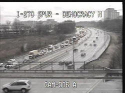
DMS in Florida
Courtesy Florida Department of Transportation
While regular traffic incidents such as highway crashes, fender-benders, and disabled vehicles affect travel at the local level and cause relatively short-term impacts, major incidents may disrupt the transportation system for days, with the disruption often spreading across multiple states. In such situations, traveler information must be disseminated across a much wider region than a single metropolitan area and targeted to long-distance as well as local travelers. Institutional and technical coordination is critical in such circumstances. Important information will often include the specific location of the incident and its effects (lane or full-road closure), alternative route information, and traffic conditions on those routes.
Example: I-95 Corridor CoalitionThe I-95 Corridor Coalition provides a forum for integrated information dissemination during incidents across the states comprising the I-95 corridor from Maine to Florida. Coalition members currently operate 40,000 miles of roadway that serve 37 percent of the U.S. population. Incident management improvements made by these agencies have had a significant effect on the nation's transportation system. While member agencies have their own individual responsibilities for collecting and disseminating incident information, the Coalition, because of its unique position and regional orientation, has enhanced this capability. Regional information is important for:
 I-95 Corridor Coalition Logo Two major incidents in early 2004 involving tanker trucks closed I-95 in both directions for significant portions of the day, one near Baltimore, Maryland, and one near Bridgeport, Connecticut. During the Bridgeport incident, requests for assistance extended as far south as Washington, DC, and to Maine in the north. TransCOM (Transportation Operations Coordinating Committee), a regional coalition of 18 transportation and public safety agencies in the New York region, activated their emergency fax and e-mail network, which has over 500 recipients in the media, trucking associations, and public agencies. The multi-agency video network system was also used to share camera images among the agencies. For the first time during a corridor incident, TransCOM requested the use of DMS and HAR to encourage drivers to switch to Amtrak. After confirming with Amtrak that seats were available, Rhode Island DOT advised drivers they could switch to Amtrak at Providence. Similarly, incident responders to the tanker crash in Maryland requested traffic operations managers in Delaware, New Jersey, Virginia, and Pennsylvania to urge travelers to find alternate routes. During the incident, state highway officials rerouted traffic on I-95 through the Baltimore-Washington Parkway and Interstate 97 using DMS, HAR, and radio and TV broadcasts. |
Traveler information is important for managing travel demand in most types of adverse weather. This includes severe weather like major snowstorms, tornados, and flooding, and commonplace weather events such as rain, fog, and high wind. (Traveler information during hurricanes is dealt with under natural disasters). Weather affects travel demand in many ways including school and work closings, road conditions and closures, and transit schedule disruptions. Travelers need weather-related information to make choices about travel mode, departure time, route selection, vehicle type and equipment (e.g., tire chains, traction equipment), and driving behavior.
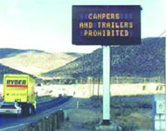
Nevada High-Wind Warning System
Courtesy Nevada Department of Transportation
Weather warnings and threat levels are often handled effectively by TV, radio, and print media; but, other ways of informing travelers include activation of flashing beacons atop static signs, posting warnings on DMS, and broadcasting messages via HAR. Route-specific road condition reports and travel forecasts are frequently provided through state agency websites. Interactive telephone systems, including 511, are also becoming increasingly popular for weather information dissemination.
Data on weather conditions for specific sites are typically collected by road weather information systems (RWIS). RWIS are a combination of detection and dissemination systems that collect, transmit, forecast, and disseminate weather and road condition information. Road-weather-sensing equipment collects data that are transmitted to automated warning systems, traffic operations centers, emergency operations centers, and road maintenance facilities. Examples of RWIS with important traveler information components include:
Example: WSDOT Weather Information SystemTo provide better information to drivers and reduce the risk of accidents, the WSDOT developed a weather warning system known as TravelAid. Dynamic message and speed limit signs were placed along a 38-mile segment of Interstate 90 that passes over the Cascade mountains through Snoqualmie Pass, an important link between the western and eastern parts of Washington State. One of the most heavily traveled east-west routes used by commercial vehicle operators, recreational drivers (i.e., skiers and holiday travelers), and commuters, the Snoqualmie Pass is prone to harsh weather conditions. Fog and rain in the summer and ice and snow in the winter make for slow travel and frequent accidents, especially in winter. The TravelAid signs are used to provide weather and roadway information to motorists to reduce the number and severity of accidents. 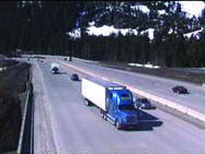 WSDOT Mountain Pass Camera Image In addition to the TravelAid signs, WSDOT provides detailed weather information on its statewide traveler information website, wsdot.wa.gov/traffic, and its 511 telephone system. The website displays road closures, fog warnings, winter storm alerts, road temperatures, and vehicle restrictions, along with images from traffic cameras. The same weather-related road conditions are reported on WSDOT's statewide 511 system. In the words of one happy customer, "I'm glad 511 has gone into effect. It's a great way to obtain highway conditions. I use it all the time to get information on Snoqualmie Pass." |
Traveler information can play a critical role in planned evacuations of people during hurricanes, floods, and other natural emergencies. By providing pre-trip and en-route travel information, emergency personnel can reduce evacuation times, decrease traveler stress, and increase safety. State DOTs typically use DMS and HAR in advance of exits and interchanges where services and alternative routes are available. Information typically includes shelter locations; alternative evacuation routes; congestion and incident information; and services such as gas stations, rest area locations, and lodging.
Many state DOTs are developing systems for evacuations in the event of natural disasters. For instance, Delaware DOT acquired a commercial FM radio station for use as a statewide travel information station. The Travelers Advisory Radio System, WTMC 1380 AM, conveys general travel information during non-evacuation periods and evacuation information in advance of hurricanes. The Florida Division of Emergency Management website, www.floridadisaster.org, provides links to hotels in Florida, Alabama, and Georgia that allow evacuees to make online hotel reservations. Florida residents contemplating travel during extreme weather can access www.dot.state.fl.us to view the statewide network of real-time traffic volume and speed data recorders.
Example: South Carolina Hurricane Floyd's Evacuation OperationsIn September 1999, roughly three million people were evacuated from coastal areas in Florida, Georgia, North Carolina, and South Carolina prior to landfall of Hurricane Floyd. Over 500,000 South Carolinians evacuated from six coastal counties. Because managers with the South Carolina DOT and the South Carolina Department of Public Safety had not agreed on a lane reversal plan prior to Hurricane Floyd, contraflow (i.e., lane reversal) was not employed during the evacuation. Consequently, travelers experienced severe congestion on Interstate 26 between Charleston and Columbia. 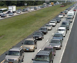 Evacuating in the Face of Hurricane Floyd Traffic and emergency managers quickly developed a contraflow plan to accommodate traffic entering in reversed westbound lanes. Managers utilized storm track, wind speed, and precipitation forecast data in combination with population den-sity and topographic information to identify areas threatened by storm surge and inland flooding. Traffic managers monitored traffic flow with two permanent vehicle detection sites along the highway and portable detection equipment on other road facilities. DMS and HAR were deployed to notify travelers of closures and alternate routes. As a result of contraflow, the maximum volume during reentry was 2,082 vehicles per hour per lane—a 44 percent increase over evacuation volumes. Contraflow operations and dissemination of traveler information significantly improved mobility by increasing roadway capacity and traffic volumes. |
During unforeseen emergencies like earthquakes, hazardous material spills, or terrorist attacks, there is often no warning or precursors to the event and travel must be managed in stressful and uncertain conditions. In such situations, traveler information can play a key role in reducing uncertainty and stress among travelers and improving system throughput. Travelers need to be told about road closures, alternate routes, transit service disruptions, disaster recovery information, and safety information. Often, catastrophic events result in long-term disruptions to travel, and traveler information can be used to provide trip planning information such as construction schedules and road closures.
Transportation officials in New York City and the Washington, DC, area (September 11, 2001), Baltimore (rail tunnel fire, July 18, 2001), and California (Northridge earthquake, January 17, 1994) all used a multi-pronged strategy to disseminate traveler information immediately after the catastrophe. Agencies used TV, radio, DMS and HAR, websites, telephone services, maps, and personnel on the street to provide information to the public.
The 511 telephone traveler information system can also support getting information to citizens at the time of an emergency. However, agencies recognize that 511 systems are likely to be "stressed" by the extremely high demands for information under those circumstances.
Example: Use of Traveler Information on September 11, 2001, in New YorkTraveler information aided both agencies and travelers on September 11, 2001, and in the months after the terrorist attacks. On September 11, alerting motorists of problems long before they reached the Manhattan area was of critical importance. DMS were used to communicate real-time information to travelers. Within 2 minutes of the decision to close the George Washington Bridge, the DMS alerted motorists 10 miles away. In the hours after the attacks, the New York DOT also deployed portable DMS at New York City bridge and tunnel entrances. 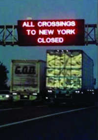 Traveler Information Posted on September 11, 2001 The regional organization TransCOM provided a cooperative, coordinated approach to regional transportation management during and after the attacks. After TransCOM alerted I-95 Corridor member agencies of problems in the New York City region, these agencies used HAR and DMS on I-95 as far south as Delaware and as far north as New Haven, Connecticut, to alert travelers to avoid the New York City region. After the terrorist attacks on the World Trade Center, transportation agencies utilized radio, TV, and newspapers to relay information on highway and transit conditions. The New York DOT also used HAR broadcasts to give up-to-date traveler information. One day after September 11, the Metropolitan Transportation Authority reported 10 million hits on its website in one day, five times the normal volume, as people tried to obtain up-to-date information on transit operations. |
1. Traveler information successfully helps manage transportation demand. Travel improvements have been documented in many areas and situations:
2. The potential for traveler information to manage transportation demand has not been fully realized.
3. Traveler information is relatively inexpensive and quick to implement, but requires an ongoing commitment from a transportation agency.
4. Public agencies need to monitor the success of their traveler information systems to maximize their investment.
5. Public and private organizations can learn a lot from failed traveler information systems. Failure stems from many causes, including technological problems, inadequate understanding of traveler behavior, poor execution, insufficient promotion, and other reasons. The difficulties and failures experienced in some of these early forms of traveler information systems are part of a normal process of trial and error that have provided useful lessons for systems that came later. For example:
6. Traveler information will need to be provided as a public service for most travelers.
7. To be successful, traveler information systems must be based on thoughtful planning and cooperation between public and private entities.
8. A marketing campaign aimed at raising awareness and stimulating usage is an essential component of a program to improve traveler information and travel demand.
Traveler information implementations are expected to become more robust and widespread due to improvements in technologies and applications. Quality and quantity of data are increasing as sensors and communication technology improve and become cheaper to deploy. Those data can be combined in ever-more-useful ways that benefit travelers, and technological evolution will ensure that travelers receive information in new ways, as well. A few examples include:
Providing Travel Time Information: Currently, most traveler information systems in the United States stop short of providing predicted travel times to commuters. However, reliable travel time information can greatly influence driver behavior including choice of route, modes, and departure times. For instance, while the locations and time of incidents are often the core elements of a typical system, commuters may not know of the travel time impacts of the incident, due to the technological limitations in estimating trip times. Transportation agencies in a few places in the United States have begun to provide estimates of travel time, such as the San Francisco Bay Area and Seattle. Moreover, the private sector sees a market for the information, and some firms now offer travel time information to their clients.
Right now travel time information is constrained by limitations in technology for collecting and processing information. Use of vehicles as probes is an extremely useful means of collecting travel time along road segments. For example, electronic toll tags create signals that can be collected and processed to estimate travel time in areas with electronic toll collection, as is the case in the San Francisco Bay Area and the New York City region. In Seattle, the WSDOT uses loop detector data to measure traffic flows on segments of freeways and applies an algorithm to those data to estimate travel time. Both these approaches to travel time signify future directions that an increasing number of traveler information systems are likely to take, so that it will become possible to tell travelers how long a route will take to traverse instead of showing them a "delays possible" sign.
Personalized Traveler Information: People are constantly bombarded with information, and new personalized travel information services are emerging as attractive options. In addition to the previously discussed "alert" services, the Georgia DOT, for example, has launched the "MyNaviGAtor" service that lets travelers set up a personal webpage as part of the DOT's website, www.georgia-navigator.com. Not only can the user select information on specific routes of interest, but the user can choose how the information is presented: maps, traffic cameras, trip times, message signs, incident and construction listings. The webpage is updated with information each time the user logs on, and the user can establish up to four different profiles for different types of trips.
A prototype of a tool for personalized traveler information has been developed by Mitretek Systems using XML (eXtensible Markup Language) to gather and display web-based traveler information. Named TripInfo, the tool enables the traveler using a web browser to access the system which generates a route, determines relevant websites along the route, contacts each site, and extracts relevant information from the site. It organizes this information into a traveler report for the specified route.
In-Vehicle Traveler Information: To enable travelers to make travel decisions while en-route requires the ability to provide up-to-date traveler information to mobile media. The use of wireless enabled devices like PDAs, cell phones, and pagers are becoming commonplace. However, in-vehicle traveler information in the United States has until recently been restricted to AM and FM radio broadcasts and localized HAR. However, this picture may soon change as new technologies achieve greater penetration in the consumer market.
The delivery of in-vehicle information is currently more prominent in Europe than in the United States. Radio data system-traffic message channel (RDS-TMC) and TrafficMaster service provide traveler information to thousands of vehicles in the United Kingdom and other parts of Europe. A survey of RDS-TMC users revealed that 50 percent of drivers changed plans, 87 percent saved time and reduced stress, and only 3 percent got the same information from another source. Drivers were reported to like having access to journey times, seeing the complete network, and getting personalized information.
Similarly, Japan's Vehicle Information and Communication System (VICS) provides real-time traffic information to travelers and commuters through in-vehicle navigation devices. Information from VICS include traffic congestion, travel time, location of accidents and roadwork, speed and lane regulations, and parking lot locations and availability. The VICS center collects information systemati-cally on road traffic conditions, and the center processes the information and transmits to navigation systems installed in vehicles using beacons set up on roads. In 2003, over eight million VICS-ready in-vehicle devices were sold.
In the United States, as in-vehicle navigation systems become increasing popular with consumers, improved methods of traveler information dissemination are possible, leading to an increased potential for managing demand en-route like influencing route choice and parking. The advent of satellite radio systems provides a new means of communicating with in-vehicle devices. For example, two firms, NAVTEQ and XM Radio, will be offering satellite traffic information service in which a vehicle's on-board navigation system can display current traffic information for a driver's chosen route. The in-vehicle devices will receive traffic incidents and average traffic speed along specific roadways throughout the country from the XM Radio satellites.
Lappin, J. 2001. "What Have We Learned About Advanced Traveler Information Systems and Customer Satisfaction?" in What Have We Learned About Intelligent Transportation Systems? FHWA-OP-01-006 (Washington, DC).
Transportation Research Board. 2003. Advanced Features of Transit Websites, TCRP Report 84 (Washington, DC).
Transportation Research Board. 2003. Transit Information and Promotion: Traveler Response to Transportation Systems Changes, TCRP Report 95, Chapter 11 (Washington, DC).
U.S. Department of Transportation, Federal Highway Administration. 2003. Innovative Traffic Control – Technology and Practice in Europe (Washington, DC).
U.S. Department of Transportation, Federal Highway Administration. 2002. Intelligent Transportation Systems in Work Zones: A Crosscutting Study (Washington, DC).
U.S. Department of Transportation, Federal Highway Administration. 2002. Managing Travel for Planned Special Events, FHWA-OP-04-010 (Washington, DC).
Federal Highway Administration
Office of Operations
400 7th Street, SW
Washington, DC 20590
202-366-6726
www.ops.fhwa.dot.gov
Federal Highway Administration
U.S.Department of Transportation
400 7th Street, S.W. (HOP)
Washington,DC 20590
Toll-Free "Help Line" 866-367-7487
www.ops.fhwa.dot.gov
EDL Document No.: 14072
Publication No.: FHWA-HOP-05-005