Mainstreaming Integrated Corridor Management: An Executive Level Primer
Chapter 2. Background on ICM
This chapter provides the definition and defining characteristics of Integrated Corridor Management (ICM), offers an overview of the United States Department of Transportation (USDOT) ICM program, and provides a brief discussion of how ICM works.
What is ICM?
ICM follows the evolution of Intelligent Transportation Systems (ITS) technologies. Agencies first deployed individual devices, followed by separate modal systems, and ultimately integrating devices and systems into multimodal ICM. ICM improves regional response — not just corridor response - by integrating existing ITS devices, systems, and assets controlled and operated by multiple agencies with multiple stakeholders, to create proactive solutions to manage demand and capacity across modes in each corridor. ICM is only possible as a result of mining "big data," which was not available as recently as a decade or so ago.
ICM is an approach designed to actively monitor for the most severe atypical recurring and nonrecurring events that impact traffic on already congested trunk highways or freeways that define a corridor. Because of near constant congestion, even minor events on an anchor facility can have a huge impact, even if those facilities may already deploy highly advanced systems like ramp metering, high occupancy vehicle lanes, or peak hour enhancements. The latter strategies do their best to mitigate an already congested facility, but one which can instantly degrade into stop-and-go speeds due to even the most minor incident.
ICM requires the institutional, operational, and technical integration of as many participating agencies as are available to combine their assets into one unified real-time response. ICM is "regional" but is often defined by the major trunk highway. Therefore, a corridor-defined region is bounded by a "travel shed" of (mostly) commute and daily trips that are germane to the subject artery highway and the subordinate parallel and coexistent modes and routes that are also germane to that shed. Think of the travel shed as a "watershed," in that a common set of streams (of traffic) "drain" into a single larger body of collection (see Table 1). In an ICM context, the "corridor" is comprised of all the multimodal options and traffic systems that exist and can reasonably service trips within the travel shed. For example, a corridor may contain a freeway management system, several arterial signal systems, transit bus routes, and a commuter rail system. At various times, all of these systems may participate in an ICM response.
| Term | Definition |
|---|---|
| Corridor | (Also, the "region,") defined by the trunk highway, and bounded by a "travel shed" of (mostly) commute and daily trips that are germane to the subject artery highway and the subordinate parallel and coexistent modes and routes that are also germane to that shed. |
| Travel Shed | The boundary of all first- and last-mile trips that have a high feasibility of using the primary facility of a given corridor. |
| Integrated Corridor Management System (ICMS) | A system designed to implement ICM within a given area. The system monitors traffic, looks for unusual events or delays, assists with decision-making and communications, and generally operationalizes the ICM strategies for the corridor. |
| Decision Support System (DSS) | Software that assists or automates portions of the decision-making process needed as part of an ICMS. The DSS monitors traffic conditions, compares to typical trends, models alternative solutions and strategies consistent with expert rules that have been programmed in, predicts the impact of those solutions, and assists with implementation and evaluation of a given response. |
| Business Rules | The agreed-upon policies, procedures, and protocols of the participating agencies that govern the way in which individuals and agencies interact within the ICMS. The business rules reflect the operational strategies and constraints that have been pre-approved by the ICM stakeholders as suitable candidates for creating response plans within an ICMS. |
Each unique travel shed, then, would have its own different ICM partners, including all proximate department of transportation regional transportation management centers, cities, or boroughs along that corridor as well as the agencies that operate in or oversee each individual shed. A neighboring travel shed of another, distinct ICM corridor would have a new mix of partner agencies and would be as different from the first one as it would be from a different region or State.
ICM goes beyond nominal (i.e., day-to-day) traffic management and traditional incident response (i.e., a detour) on a highway, as those operational practices are typically only reactive and do not include ICM's proactive engagement of other agencies' assets on parallel routes or alternate travel modes. ICM strategies are characterized by actively changing signal timings, promoting (and if need be, temporarily increasing) transit alternatives, providing bus bridges, modifying toll rates, changing ramp meters, and generally flexing the entire corridor to absorb the congestion vent rather than merely responding only near the event on the subject anchor highway.
ICM combines two fundamental concepts: active management and integration. Active management involves real-time monitoring and assessing performance of the transportation system and dynamically implementing responses to fluctuations in demand. In ICM, all individual facilities are actively managed so that operational approaches can be taken in real-time in response to events anywhere in the system. Integration requires actively managing assets in a unified way so that corrective actions can be taken to benefit the entire corridor, and not just parts of it. Integration occurs in the following three dimensions:
-
Institutional Integration — Involves the coordination and collaboration between multiple agencies across jurisdictions (i.e., transportation network owners) in support of ICM. This includes the distribution of specific operational responsibilities and the sharing of control functions that transcend institutional boundaries.
-
Operational Integration — Involves the implementation of multi-agency transportation management strategies, often in real-time or planned, and promotes the sharing and coordination operations across the transportation networks in the corridor to facilitate the management of the total capacity of the corridor.
-
Technical Integration — Provides the means (i.e., communication links, system interfaces, and associated standards between agencies) by which system information, operations and control functions are effectively shared and distributed across the transportation network. It also provides agencies and their respective transportation management systems with immediate information on the impacts of operational decisions, so that agencies can evaluate their impacts and take corresponding action.
Table 2 below describes the defining characteristics of ICM. As shown by the various dimensions, ICM can be characterized as multimodal, multijurisdictional, traveler/person-focused, integrated, proactive, comprehensive, and collaborative. In other words, agencies having an ICM mindset work collaboratively across modal and jurisdictional boundaries to integrate their systems for the benefit of people traveling in and through the corridor.
ICM can be characterized as multimodal, multijurisdictional, traveler/person-focused, integrated, proactive, comprehensive, and collaborative.
| Dimension | ICM is not... | ICM is ... |
|---|---|---|
| Facilities/Modes/Networks | Primarily unimodal, such as a freeway network, arterial streets, and transit routes that simply co-exist | A multi-modal network encompassing the main transportation options within a corridor/travel shed |
| Integration of Transportation Systems | Separate systems (e.g., freeway management, arterial signal, incident management, or bus Automatic Vehicle Location (AVL) system) | Integrated, system of systems |
| Priority | Moving vehicles | Moving people (travelers) and goods |
| Jurisdictions | Optimizing for an individual jurisdiction | About solving travel problems across multiple jurisdictions |
| Traveler Information | Separate information for drivers and transit users | Updated information across all modes in a corridor, coordinated with the Integrated Corridor Management Systems (ICMS) |
| Operations decisions within the corridor | Independent, agency specific actions | Coordinated and communicated actions |
| Agencies and stakeholders | Optimizing an individual agency's system | Multi-agency collaboration and coordination |
| Performance monitoring | Vehicle-focused measures | Traveler focused, multimodal measures |
| Approach to response plans? | Reactive, ad-hoc | Proactive, pre-planned, predictive |
Background on the ICM Program
The USDOT initiated the ICM Program to research the integration of transportation networks within urban travel corridors. Starting in 2006, USDOT began research into ICM as an approach in congestion management, by optimizing the use of existing infrastructure and assets, and by leveraging unused capacity along our nation's corridors. The ICM Program Objectives are provided below.
ICM Program Objectives:
- To demonstrate and evaluate pro-active integrated approaches, strategies, and technologies for efficient, productive, and reliable operations.
- Provide the institutional guidance, operational capabilities, and ITS technical methods needed for effective Integrated Corridor Management.
The ICM program consisted of four phases, as detailed in Figure 1. A brief description of these phases is provided below.
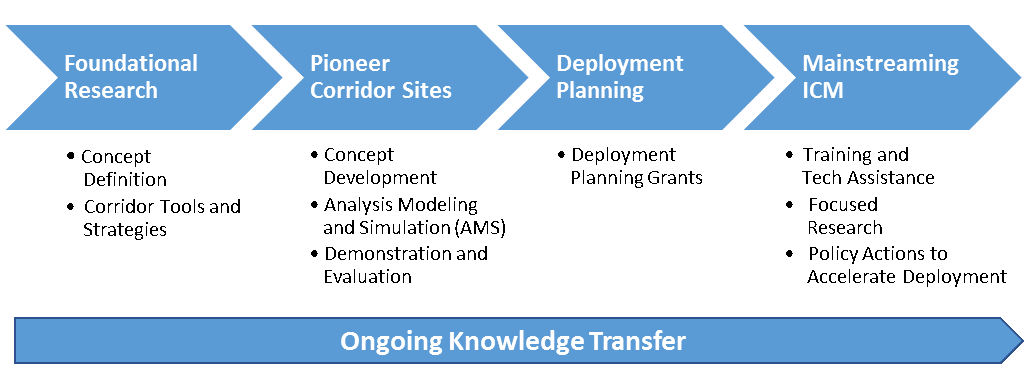
Figure 1. Chart. Major Phases of the USDOT ICM Research Program
(Source: USDOT)
During Phase one, foundational research was performed to understand both the institutional, operational, and technical integration required of corridor management and the development mitigation strategies. Phase two solicited actual corridor stakeholders, termed the Pioneer Sites, via a competitive funding process to develop concepts for the integrated operation of corridor networks, to analyze the benefits of demonstrations, and then conduct two large-scale ICM demonstrations in San Diego, CA and Dallas, TX. The eight pioneer sites (noted in Table 3) were selected from across the U.S. and had representative configurations and characteristics of similar corridors across the country. The Pioneer Sites development process was divided into three stages. In Stage one, the eight pioneer sites developed concepts of operations (ConOps) and system requirements for implementing ICM in their corridors. Stage two involved analysis, modeling and simulation (AMS) of ICM strategies on three corridor networks (Dallas, San Diego, and Minneapolis). In Stage three, two large-scale ICM demonstrations (I-15 in San Diego, CA and US-75 in Dallas, TX) were implemented and evaluated.
| Pioneer Site Locations (City and State) | |
|---|---|
| Dallas, TX
Houston, TX San Antonio, TX San Diego, CA Oakland, CA |
Minneapolis, MN
Seattle, WA Montgomery County, MD |
Phase three built off the success of Phase two's Pioneer Sites and provided competitive grant funding for an additional 13 sites across 10 States to develop "pre-implementation" documents and begin active planning for integrated corridor management systems. A total of 33 sites applied and 13 were selected in highly congested areas. See Table 4 for a list and Figure 2 for a map of the 13 selected corridor locations. The planning grants provided assistance in the development of pre-implementation documents, such as Concept of Operations (ConOps), System Requirements (SyRS), Analysis Modeling and Simulation Plans, and/or ICM Implementation Plans.
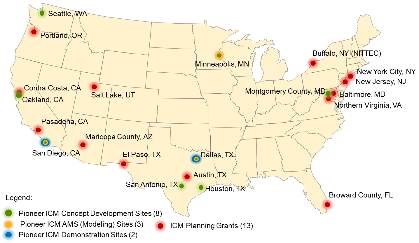
Figure 2. Chart. ICM Pioneer Site and Implementation Planning Grant Corridor Locations
(Source: USDOT)
| State | Lead Agency or City | Corridor Description |
|---|---|---|
| Arizona | Maricopa County | I-10 through the Phoenix metro area and multiple east-west parallel routes. |
| California | California Department of Transportation (Caltrans) | I-210 on a 22-mile section from the 134/210 interchange near downtown Pasadena to the Foothill Boulevard Interchange in La Verne. |
| California | Contra Costa County | State Route (SR)-4 in the city of Hercules from I-80 to I-680. |
| Florida | Broward County | I-95 on a 25-mile section in Broward County. Commuter rail, transit bus service, inter-city rail (including Amtrak) park & ride lots and bike trails. |
| Maryland | Maryland State Highway Administration | Three corridors connecting Washington, DC and Baltimore: I-95, MD 295 (the Baltimore-Washington Parkway), and US 1 between MD 32 and I-695. |
| New Jersey | New Jersey Department of Transportation (NJDOT) | New Jersey Turnpike (I-95), Garden Parkway and US 1 and US 9 from Woodbridge (south) to the Holland Tunnel (north). |
| New York | City of New York | In the New York/New Jersey metro area, the corridor includes sections of Route 495 (the Long Island/Queens-Midtown Expressway) and crosses midtown Manhattan, the Lincoln Tunnel and the Queens-Midtown Tunnel. |
| New York | Niagara International Transportation Technology Coalition (NITTEC) | I-90 within the Buffalo-Niagara region, including the Peace Bridge and the I-190/I-90 interchange to the south and the I-190/I-290 interchange to the north. |
| Oregon | City of Portland | I-84 from downtown Portland encompassing over 45 square miles. Light rail and streetcar routes. Local streets. Bus and bike routes. |
| Texas | City of El Paso | IH-10 from US-54 to Loop 375, US-54/IH-110 from IH-1 to Loop 375. This project is 16 miles combined. Bus routes. |
| Texas | City of Austin | IH-35 between US 183 and State Highway (SH) 71 |
| Utah | Utah Transit Authority (UTA) and Utah Department of Transportation (UDOT) | Major north-south roadways, representing approximately 25 miles, from downtown Salt Lake City to Lehi City, including I-15, State Street and Redwood Road. Commuter rail services. |
| Virginia | Virginia Department of Transportation (VDOT) | Northern Virginia east-west corridors including I-66, SR 7, US 29, US 50 and SR 267. The Virginia Railway Express Manassas line, Metro Silver and Orange lines, commuter bus routes, and commuter parking lots. |
The fourth and final phase of the ICM research program is referred to as "Mainstreaming ICM" and focuses on mainstreaming ICM concepts and strategies, through efforts such as this primer, to encourage further adoption of ICM, and consists of the continued knowledge transfer of ICM concepts, methods, tools, and products, to encourage the adoption of ICM into everyday transportation planning, project development, and operations. Mainstreaming activities also include focused research to assist with deployment challenges and policies to encourage deployment, such as establishing ICM as an eligible or even preferred project type in various deployment grant programs. Note that knowledge transfer activities have been an ongoing part of every program phase, as shown by the continuous activity bar in Figure 1.
For additional information regarding the ICM Program, please see Integrated Corridor Management (ICM) Program: Major Achievements, Key Findings, and Outlook. See chapter 6 for more information on this resource.
How Does ICM Work?
Very briefly, ICM is implemented through a system, called an integrated corridor management system (ICMS) with a decision support system (DSS) that monitors traffic conditions in the corridor, looking for anomalies in traffic patterns or significant events that change the traffic situation enough that alternative approaches to managing the multimodal corridor should be evaluated for possible implementation. Once an atypical event triggers such an evaluation, then the DSS will model one or (often) more alternative solutions (composed of multiple strategies that stakeholders have agreed could be implemented by the different agencies) as compared to the "do nothing" alternative. If the alternative solutions are predicted to be significantly better than the "do-nothing" alternative, the solution with the best outcome is recommended for approval by an ICMS operator(s) or coordinator and instituted in real-time.
The DSS then continues to monitor network conditions after the response plan is implemented to determine if it is working or further adjustments are needed. The DSS can have varying levels of capability and support and may involve more or less human involvement in the process of evaluating and implementing the strategies. The strategies that the DSS evaluates have been pre-approved and agreed to by the individual agencies and are the business rules that the DSS is programmed to evaluate. The strategies can include providing pre-trip and en-route traveler information, recommending and guiding travelers to diversion routes or alternate modes, modifying the traffic signals or ramp meters to accommodate more traffic, temporarily adding capacity to transit modes, facilitating smooth transfers at network junctions, and many other options. Resources and more information on DSS can be found in chapter 6.