Measures of Effectiveness and Validation Guidance for Adaptive Signal Control Technologies
Chapter 4. Candidate Measures of Effectiveness for Validation of Operational Objectives
A variety of MOEs have been used to measure ASCT performance. New measures and approaches are emerging as high-speed IP technology has enabled easier access to high-resolution signal timing data. The following MOEs are presented and identified as candidate measures to validate that ASCT meet their operational objectives. Note that the use of the word “validate” is important here. In order to validate that an ASCT or any mitigating strategy has met its operational objective it does not necessarily need to have a base scenario to be compared with. If the validation is done with respect to a baseline performance, then that traffic condition needs to be as statistically similar to the scenario that is controlled with the ASCT as possible. As discussed in the previous section, this is one of the main challenges of evaluation studies. Simulation testing is most suited for this kind of validation comparison, but simulation testing is expensive, time-consuming, and results in yet a different set of issues due to modeling assumptions, behavioral rules and input data.
To the extent that data and corresponding MOEs are available for a statistically similar base scenario, as long as the ASCT provides acceptable performance on the objective, the ASCT should be considered to be validated. If data and corresponding MOEs are not available from a baseline scenario, which would be most common for incidents, similar situations may have to be created artificially in the field. For example, using traffic cones or agency vehicles to create simulated breakdowns or lane closures for both situations with and without ASCT might be used as a surrogate technique for validation of the functionality.
In addition, validation does not imply any absolute measurement that an ASCT is superior to any other available option, including implementation of alternative fixed timing plans or any of the other wide ranging features of actuated-coordinated controllers. In many cases, simple adjustments to actuated operation can go a long way towards accommodating variability without the expense and complexity of adding ASCT. Many of these valuable features are identified in FHWA-HOP-11-027.
Each ASCT has a different set of formulas, rules, and optimization functions that contribute to the effectiveness of the timings that are implemented in the field at any time. It cannot be known implicitly what the optimal response could have been without a) perfect knowledge of the state and intentions of every system user, and b) a specific optimization goal is agreed upon. The performance of one ASCT versus another cannot be compared absolutely unless they are all given exactly the same problem to address. This cannot be done in any real world situation since no two systems can be brought to bear on exactly the same traffic at exactly the same time.
Table 3 summarizes candidate MOEs for each operational objective. Each MOE is denoted as a candidate since it is not necessary to calculate or compare all of the measures to validate the functionality of a system. Each MOE also has a different level of difficulty in implementation or interpretation. In the sections following the table, we provide a definition of each measure and some discussion of the data requirements to compute the information. The measures and techniques identified as candidates are all generic measures that are not part of the calculation engine of any particular ASCT system. Measures from ASCT systems that are described in the open literature are not considered candidate MOEs in order to keep the process as generic and transparent as possible.
Table 3. Candidate MOEs for Validation of Operational Objectives.
| Operational Objective |
Candidate MOEs |
| Smooth Flow |
Route travel time, delay, average speed
Link travel time, delay, average speed
Green bandwidth on route
Percent arrivals on green, by link
Platoon ratio, by link
Number of stops per mile on route |
| Access equity |
Phase green to occupancy ratio by movement
V/C ratio by movement
Queue length by movement |
| Manage queues |
Queue length by movement
Number of stops per mile on route
Time to process equivalent volume |
| Throughput |
Time to process equivalent volume
Traffic volume |
| Changing objectives by TOD |
Covered by MOEs from other objectives |
Route Travel Time
Route travel time is defined as the time it takes to travel from a given origin to a given destination along a given route. Travel time is the most commonly used measurement in evaluation of traffic system performance. The best possible travel time in a traffic system is defined as the time it would take to travel from origin to destination at the free-flow speed for each link in the route. Travel time is defined with respect to a given route distance; so it is not a measure that can be compared from one site to another. Similarly, route travel time can depend on the level of traffic demand.
There are several technologies that are available for measurement of travel time. They generally fall into one of two groups:
- GPS probe vehicles.
- Vehicle re-identification technology.
Probe vehicle data is good for collecting detailed performance for each component of a route but is expensive to collect to comprehensively cover the various traffic situations (a.m., p.m., mid-day, off-peak, weekend, traffic patterns, day of week, etc.) of interest. Probe vehicle data sources include laptop applications, phone and tablet apps, and proprietary ATIS data.
Vehicle re-identification technology (Bluetooth, vehicle signatures, license plate reading) is able to record 24/7 information for the end-to-end trip time on a route, but cannot provide detailed information on vehicle performance in between the end points of the trip. Based on the technology type, vehicle re-identification methods can only record a sample of the total traffic stream. In most situations, this sample should be considered adequate for the purpose of validating objectives. As early as 2009, there are literatures that describe data collection using Bluetooth-enabled MAC address readers, GPS-enabled data loggers and signal systems with better logging and vastly expanded storage capabilities. The Bluetooth devices are described in Tarnoff (2009) and Caltrans (2010). Other techniques using magnetometers and license-plate readers report positive re-identification, from one array to another can range from 50 to 70 percent depending on the spacing and geometry of an arterial.
Route Average Speed
Route average speed is simply the route distance divided by the travel time. Average speed can be measured by GPS probe data and vehicle re-identification systems. Similar to travel time, average speed is sensitive to traffic volume, speed limit, and link types.
Link Travel Time/Link Average Speed
Link travel time and link average speed is defined as the travel time (average speed) from the beginning of a street link to the limit line or stop bar of the next traffic control device. Notionally a route contains more than one link. Technologies for collecting this data are the same as for route travel times and average speeds. System advance detection and mid-block speed trap sensors are also frequently used to measure link average speed (as well as volume and occupancy levels). Single-zone sensors are not particularly accurate in recording speed estimates as they rely on assumptions of average vehicle length. Various types of sensor technology (video, loops, radar, etc.) induce their own biases as well. Other sources should be consulted for more information on sensor technology benefits and challenges.
Route Travel Delay
Route travel delay is defined as the difference between the time it takes to travel from a given origin to a given destination along a given route, and the time it would have taken to travel that route at the free-flow speed for each link in the route, without having to stop. Technologies for collecting this data are the same as for route travel times and average speeds.
Link Travel Delay
Link travel delay is defined as the difference between the time it takes to travel from the beginning of a given link to the limit line or stop bar of the end of the link, compared to the time it would have taken to travel that link at the free-flow speed. Technologies for collecting this data are the same as for route travel times and average speeds.
Route Traffic Volume
Route traffic volume is defined as the number of vehicles that travel from the origin to the destination of a route in a given period of time. Throughput is measured as the rate of flow, so volume is the direct measurement of throughput.
There are several technologies that are available for measurement of traffic volume. They generally fall into one of two groups:
- Point sensors (road tubes, mid-block sensors, exit sensors).
- Vehicle re-identification technology.
Road tubes, mid-block sensors, and exit sensors (i.e., sensors that measure the traffic on the departure leg of an intersection) are frequently used to measure traffic volume. Most systems can be configured to provide reliable data. Various types of sensor technology (video, loops, radar, etc.) induce their own biases. Other sources should be consulted for more information on sensor technology benefits and challenges.
For the purpose of ASCT validation, the main challenge of using point sensors for measuring traffic volumes on a route is that this technology does not accurately reflect the origin-to-destination volume, and rather reports the total volume that crosses that point during a given time. This would thus include traffic from every other route with that destination including side-street turning flows. Methods such as identified by (Fehon et al., 2010) can be used to generate estimates of total travel time and total delay impacts from probe runs and volume collection.
Vehicle re-identification technology (Bluetooth, vehicle signatures, license plate reading) is better than point detection at identifying particular trips on a route, but cannot capture the exact number of vehicles on the route because they can only record a sample of the total traffic stream. In most situations, this sample should be considered adequate for the purpose of validating objectives, rather than generating total impacts that can be used for further extrapolation for B/C estimation.
Time to Process Equivalent Volume
A variation of the measurement of throughput for a fixed time period is to measure the time in which it takes for a given number of vehicles to be processed by a system. This MOE allows comparison of two methodologies to react to incident or event conditions, or to manage the shoulders of the peak period. This metric is simply a variant of throughput, so it can be computed from the same technologies and data used to compute throughput. It will be important to aggregate the volume data in small enough intervals for accurate comparisons. Five-minute summaries should be sufficient.
Green Bandwidth on a Route
The bandwidth (number of seconds) of the green time along a route can be used as a surrogate indicator for the performance of the travel on a route. Bandwidth only indicates opportunities for progression, rather than the real performance. Most past evaluation studies have not used green bandwidth in any performance assessments. Since ASCT are continually modifying the splits, offsets, and other parameters, the green bandwidth on any route will be changing. Green bandwidth can only be evaluated by obtaining high-resolution phase timing data (i.e., event-based data on each interval change or second-by-second status) from the ASCT or underlying signal system.
Percent Arrivals on Green
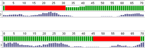
A measure of individual phase progression performance is the percent arrivals on green. This measure estimates the proportion of vehicles that arrive to a green light versus the proportion that arrive to a red light. This provides an estimate of total stops, and identifies the quality of the offsets between two coordinated intersections. This measure can be obtained through monitoring of high-resolution occupancy measured by advance detectors on the coordinated approach and high-resolution phase timing data from the ASCT or underlying signal system. This concept is illustrated in Figure 3.
Figure 3. Illustration. Illustration of Data Used to Calculated Percent Arrivals on Green.
(Source: Kimley-Horn and Associates, Inc.)
From several cycles of cycle-by-cycle occupancy data for each second in the cycle, the average occupancy for each second over a cycle is calculated. This is illustrated in Figure 3. Similarly the proportion of time when the coordinated phase is green over each second of the cycle is calculated for the same time interval. This is illustrated in Figure 3 in the row below the cycle time. The average percent arrivals on green is then calculated by the percentage of the total detector profile that is correlated with a green phase indication after shifting the detector profile several seconds to account for the travel time from the detector location to the stop bar. Alternatively, one could calculate the percent arrivals on green for each cycle, and then average the percentages to obtain an average percentage of arrivals on green for a time period.
Simple calculations for percent arrivals on green do not inherently take into account queues at the stop bar that might fill in from side-street phases during the red interval. As such, shifting the arrival profile forward based on the travel time to the stop bar will slightly overestimate the quality of nonstop progression on a given link. Other research, such as work by University of Minnesota (Liu and Ma, 2009), attempts to generate virtual vehicle profiles (similar to those drawn on time-space diagrams by your optimization software of choice) that estimate the percentage of arrivals on green and the length of the queue. This technique is discussed further in the section on queue measurements.
The percentage of arrivals on green provides an estimate of the coordinated performance of a specific link, but not on a whole route. Since the percentage of arrivals on green is a ratio measure, it is comparable across a range of cycle times and green times. Such a measure can be automatically and continuously computed from high-resolution data and thus does not require probe information or ancillary vehicle re-identification systems and equipment. The reader is pointed to the papers referenced in this report for more detail.
Platoon Ratio
Platoon ratio is a measure of individual phase progression performance derived from the percentage arrivals on green such that Rp=%arrivals_on_green*(C/g) when C is the cycle time and g is the green time (Smaglik et al., 2007). This measure is derived from the HCM definition of arterial performance (ITE, 2000; 2010) as illustrated in Table 3. Smaglik, Bullock, and Sharma (2007) identified the use of arrival type (AT) as a better means to measure the effectiveness to describe the quality of progression from one signalized intersection to the next along a coordinated corridor. The AT parameter is based upon the percentage of vehicles arriving during the green indication, when they arrive during the green interval, and the density of the arriving platoon. The AT parameter is important to signal operators for two reasons.
Table 4. HCM Arrival Type to Platoon Ratio Assignments.
| Arrival Type |
Range of Platoon (Rp) |
Default Value (Rp) |
Progression Quality |
| 1 |
≤0.50 |
0.333 |
Very poor |
| 2 |
>0.50-0.85 |
0.667 |
Unfavorable |
| 3 |
>0.85-1.15 |
1.000 |
Random arrivals |
| 4 |
>1.15-1.50 |
1.333 |
Favorable |
| 5 |
>1.50-2.00 |
1.667 |
Highly favorable |
| 6 |
>2.00 |
2.000 |
Exceptional |
Source: ITE Highway Capacity Manual 2000.
First, it provides a method for accounting for delay experienced along a coordinated arterial for analysis using the HCM delay equations. Second, it provides a measurement that can be used to assess the performance of an arterial signal system’s progression quality. However, it has been shown that collecting accurate data on quality of progression using the methodology set forth in Chapter 15 of the HCM is difficult and extremely labor-intensive, as it requires the evaluation of the performance of multiple approaches over several time periods. The Smaglik et al. (2007) study concluded that an on-line quantitative progression quality assessment tool is needed, which is enabled by access to high-resolution phase timing and detector information. Similar to percent arrivals on green, the measure requires no probe data or vehicle re-identification equipment.
Similar to percent arrivals on green, the platoon ratio applies to an individual link, but not a whole route. Since the percent arrivals on green is a percentage or ratio measure, and the platoon ratio is a simple transformation of that, the platoon ratio is comparable across a range of cycle times and green times. Figure 4 illustrates how the arrival type can be used to graphically compare two signal timing conditions.
Figure 4. Illustration. Arrival Type Performance Before and After Offset Modifications.
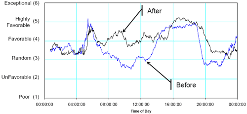
(Source: Bullock et al., 2008.)
Number of Stops per Mile
The number of stops ona route is an important performance measure for smooth flow and queue management objectives. In most literature, a “stop” is defined as a prolonged period of time that the vehicle is traveling less than some threshold speed (e.g., <three mph, for >10s). Joining the back of a queue and then creeping a few feet every few seconds is not typically recorded as multiple stops unless the vehicle proceeds above the threshold speed for a prolonged period (e.g., 10s) before returning to a speed below the threshold again. Recording the number of stops requires high-resolution GPS probe data that can report vehicle location and speed on a frequent basis, at least every one to three seconds. The total number of stops on a route is an important measure, but it is not comparable from one location to another due to the dependency on the route distance. The number of stops per mile is suggested to provide a more comparable, generic measure.
Phase Green Occupancy Ratio
The degree of saturation is the primary indicator of phase performance from the historical HCM (2000; 2010). The degree of saturation indicates the suitability of the split time to the arriving demand but is difficult to measure directly since it requires knowledge of arrival demand (not served volume). One surrogate for this is the green occupancy ratio (Smaglik et al., 2011). This measure is simply the ratio of the detector occupancy during the green phase to the total green available in the split, with a minor adjustment for the “unusability” of green time that occurs between following vehicles. This metric is typically computed using sensors at the stop bar and requires high-resolution phase and detection data, particularly occupancy data.
As shown in Figure 5, the green occupancy ratio (GOR) overestimates, but reasonably tracks, the volume to capacity ratio. The GOR is also affected by the length of the detection zone. GOR is a measure that ranges by definition from zero to one. As defined, there is no available extension to this methodology for capturing degree of saturation values that exceed one.
Figure 5. Illustration. Illustration of Comparison of Detection Length on Calculation of GOR and V/C.
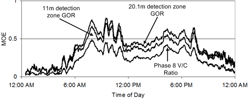
(Source: Smaglik, 2011.)
Served Volume to Capacity Ratio
Served Volume to Capacity ratio is another surrogate for the degree of saturation. (Smaglik et al., 2011) also shows that this measure can be computed from high-resolution phase and detector data, such that:
Figure 6. Equation. Served Volume to Capacity.
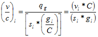
(Source. Smaglik, 2011.)
Where vl is the observed volume during green, gl is the green time, C is the cycle time, and sl is an estimate of the saturation flow rate. qg is equivalent to vl. Since this measurement is based upon volume or counts, long detectors at the stop bar or limit line are not particularly suited for measurement. Counting sensors or very short zones should be used for this purpose.
Queue Length by Movement
Queue length is an important MOE for a variety of objectives. Almost no previous evaluation approaches discuss measurement of queues except on side-streets using manual observer (HCM) methods. Many ASCT use estimates of queues to model traffic performance and optimize timings. Queue length is typically reported as a distance (feet, meters) or as a number of vehicles (or passenger vehicle equivalents, in the case where trucks and buses are in the queue). Accurate measurement of queues has historically been difficult to do due to a wide range of factors, including mid-block sources, sinks, turning traffic, and technology. Some video systems can be configured to measure and report queue distances but are constrained by their field of view.
NCHRP 03-79 describes the input-output and hybrid input-output calculation methods that can be used to compute queue lengths up to the point of the advance detector, using high-resolution phase timing and detector information (Bonneson et al., 2005). If the detector is placed as an exit detector, a queue the entire length of the link can be measured. Placement of detection at exit points is typically cost-prohibitive, unless already required by the ASCT itself.
Another queue estimation method is available that can determine queue length from advance sensors (Liu and Ma, 2009). This method uses a macro traffic model based on the fundamental diagram to estimate the length of the queue from high-resolution phase and detector data (see Figure 7).
Figure 7. Illustration. Example Queue Length Estimation Results.
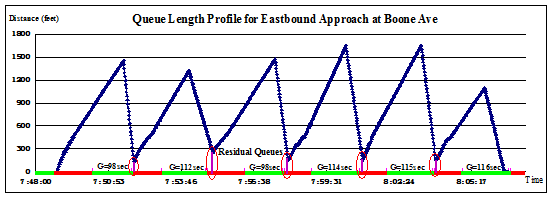
(Source: NCHRP 03-90 Final Report, pending.)
This method has been shown in field trials to produce acceptable results on high-speed arterials. The University of Minnesota is currently testing the performance in locations with short links and grids; some testing on short links was done as part of NCHRP 03-90 (publication pending). The concept has been patented and a small business has been established to commercialize the technology, although the algorithms are available in the open literature. Two of the strengths of this method are the ability to estimate queues further upstream from where the detector is placed, and the ability to estimate quantitative measures of oversaturation. One weakness of the approach is that currently the theory can only estimate a queue that is at maximum two times the length that can be serviced in one green phase.
Oversaturation Metrics
The degree of saturation (DoS) for a phase can be greater than one when the demand exceeds the capacity. This is commonly referred to as oversaturation. DoS of 1.3 for example would indicate that there is 30 percent more demand for the phase than the green time will allow. In this situation, the queue will grow without bound unless the green time is increased, or the arrival rate is decreased. Preventing the onset of oversaturation and recovering from oversaturation is one of the key objectives that may be able to be addressed by deployment of ASCT. Limited discussion of quantification of these situations is available in existing literature.
By modifying green times, ASCT can prevent overflow queues from occurring or flush out queues faster in recovery. There are very limited techniques for measurement of oversaturation. As part of NCHRP 03-90, two metrics for oversaturation intensity were developed. One metric represents the amount of green time in the cycle that is spent servicing the queue from the previous cycle (Temporal Oversaturation Severity Index) and the other metric represents the amount of green time in the cycle that is wasted because of downstream blockage (Spatial Oversaturation Severity Index) [publication is pending]. The technique was developed as an extension to the queue estimation work of Liu and Ma. Table 5 illustrates typical results for these metrics for a short link between two intersections that experiences both an overflow queue and downstream blockage due to a short 15-minute surge in traffic demand.
Table 5. Example Quantitative Measures of Oversaturation.
| Cycle Start |
Available Green(sec) |
OSI: Created by Overflow Queue – Overflow Queue |
OSI: Created by Overflow Queue – Unusable Green (sec) |
OSI: Created by Overflow Queue – T-OSI (%) |
OSI: Created by Spillover – Unusable Green (sec) |
OSI: Created by Spillover – S-OSI (%) |
| 17:06:31 |
136 |
0.0 |
0.0 |
0.0 |
0.0 |
0.0 |
| 17:09:31 |
136 |
0.0 |
0.0 |
0.0 |
3.0 |
2.2 |
| 17:12:31 |
136 |
89.6 |
0.0 |
0.0 |
28.0 |
20.6 |
| 17:15:31 |
136 |
164.3 |
7.2 |
5.3 |
28.8 |
21.2 |
| 17:18:31 |
136 |
0.0 |
13.1 |
9.7 |
15.0 |
11.1 |
| 17:21:31 |
136 |
180.4 |
0.0 |
0.0 |
41.7 |
30.6 |
| 17:24:31 |
135 |
165.3 |
14.4 |
10.7 |
34.1 |
25.2 |
| 17:27:31 |
139 |
138.2 |
13.2 |
9.5 |
25.2 |
18.1 |
| 17:30:31 |
120 |
125.3 |
11.1 |
9.2 |
16.3 |
13.6 |
| 17:33:31 |
141 |
0.0 |
10.0 |
7.1 |
8.6 |
6.1 |
| 17:36:31 |
135 |
0.0 |
0.0 |
0.0 |
0.0 |
0.0 |
Source: Liu, Wu, and Gettman, 2010.
One limitation of the indices is that these metrics only scale from 0 to 100 percent. Extended modeling concepts would be required to estimate situations where queues are so long that multiple green intervals are required before a vehicle in the queue is serviced.
Reliability of Travel Time
Reliability in travel time is an important aspect of the effectiveness of ASCT. Reliability measures have rarely been estimated in previous signal system evaluations. Figure 8 illustratesillustrates the potential improvements of a mitigation strategy that are ignored if the focus is only on the change to the average performance.
Figure 8. Illustration. Representation of the Value of Reliability Improvements.
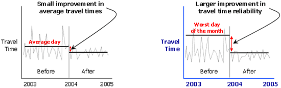
(Source: Federal Highway Administration, 2008.)
The most effective methods of measuring travel time reliability are to use the 90th or 95th percentile travel times, buffer index, and planning time index, as explained in the following sections.
Several statistical measures, such as standard deviation and coefficient of variation might also be used. However, they treat early and late arrivals with equal weight. Assumptions of Normal distributions should not be used for this purpose as travel time performance is not symmetric with respect to the mean value. A Poisson or Beta distribution is more appropriate, but most standard statistical techniques applied in the literature use the assumptions of Normality.
90th or 95th Percentile Travel Times
Computing the 90th or 95th percentile travel time is perhaps the simplest method to measure travel time reliability. With enough observations, the value can be simply determined. With fewer observations, a statistical model is needed to predict what the 95th percent percentile value would be.
Buffer Time
The buffer time represents the extra time (or time cushion) that travelers must add to their average travel time to ensure on-time arrival. For example, a buffer index of 40 percent means that for a trip that usually takes 20 minutes a traveler should budget an additional eight minutes to ensure on-time arrival 95 percent of the time.
Average travel time = 20 minutes
Buffer index = 40 percent
Buffer time = 20 minutes × 0.40 = 8 minutes
The eight extra minutes is the buffer time. Therefore, the traveler should allow 28 minutes for the trip in order to ensure on-time arrival 95 percent of the time.
Planning Time
The planning time represents how much total time a traveler should allow to ensure on-time arrival. While the buffer time represents the additional travel time that is necessary, the planning time is just the total travel time that is necessary (see Figure 9).
Figure 9. Illustration. Reliability Measures Compared to Average Congestion Measures.
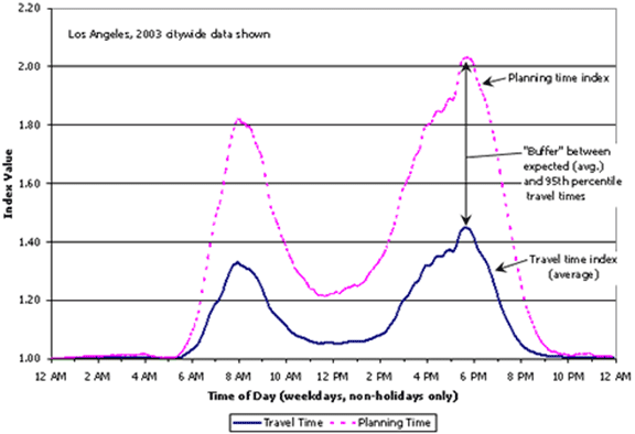
(Source: Urban Congestion Reports.)
Reliability Indices
Both of these measures can also be expressed as indices to compare one route to another. For example, a planning time index of 1.60 means that for a trip that takes 15 minutes in light traffic a traveler should budget a total of 24 minutes to ensure on-time arrival 95 percent of the time.
Normal travel time = 15 minutes
Planning time index = 1.60
Planning time = 15 minutes × 1.60 = 24 minutes
The planning time index is especially useful because it can be directly compared to the travel time index on similar numeric scales. The travel time index measures the ratio of the difference between the best observed travel time and the average travel time.
Like percentages, these ratios can become nonsensical when the route distance or time is very short. If the normal travel time is four minutes but the 95 percent travel time is six minutes, the planning index is 1.5. Reporting and comparing ratios of this nature is always challenging. Figure 9 illustrates the relationship between the buffer index and the planning time index. The buffer index represents the additional time that is necessary, whereas the planning time index represents the total travel time that is necessary.
Reliability measures of travel time are derived from the base measurements and thus require no additional data collection systems or methods.
Reliability of Phase Performance
Reliability in travel time is an important aspect of the effectiveness of ASCT. Reliability in other measures is similarly important to measure changes in mitigation strategies. As illustrated previously, Figure 8 illustrates the potential improvements of a mitigation strategy that are ignored if the focus is only on the change to the average performance.
One metric that has been proposed to capture the reliability of phase performance is phase failures. A phase failure occurs when the traffic demand exceeds the green time for a phase resulting in an overflow queue that must be serviced in the following cycle. A control strategy that reduces the number and frequency of phase failure events would is considered more reliable. (Smaglik et al., 2006) describe simple diagnosis techniques from high-resolution phase and detector data for marking suspected phase failures, such as indicated by v/c ratios that are > 1.0 as illustrated in Figure 10.
Figure 10. Scatter Graphs. V/C Ratio by Phase by Time of Day.
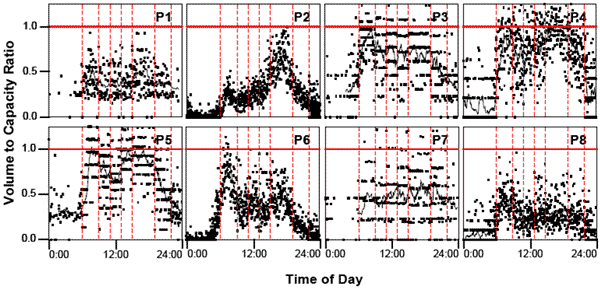
(Source: Bullock et al., 2008.)
Plots are helpful for humans to make decisions and assess comparative performance, but such displays must be translated into numbers for quantitative comparisons. Signal systems have long included split monitoring functions that tabulate average and variance of phase times for given time of day. Typical split monitor summary statistics are shown in Figure 11. Similar tabulation of v/c estimates and other metrics such as phase failures computed on a cycle-by-cycle basis could be used to compare the reliability of phase performance.
Figure 11. Screen Shot. Example Split Monitoring Summary Statistics.
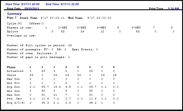
(Source: Miami-Dade County, FL signal system, 2011.)
Derived MOEs
Impact on society and the public is also of importance in assessing the performance of ASCT against their operational objectives. Reduction in fuel use, emissions, and dollar-cost impact or benefit/cost ratio are typically used to estimate impacts on society. Most past studies include some discussion of these impacts to ensure that the system was a valuable investment. There are several assumptions that are necessary to convert from objective measurements such as travel time to societal impacts. While societal impact measures are valuable to estimate, they should not be used to compare the effectiveness or value of one system versus another.
Fuel Use
Fuel use for an individual trip can be computed from GPS probe vehicle trajectories using assumptions about vehicle make/model. Extrapolating individual probe performance to fleet impacts requires assumptions about the mixture of the fleet in a given locale, including the distribution of make/model/year/condition/environment and the percentage of trucks and other heavy vehicles.
Emissions
Emissions output for an individual trip can be computed from GPS probe vehicle trajectories using assumptions about vehicle make/model/condition/environment. A variety of tools are available, including MOBILE6, CMEM, MOVES, and VT-MICRO. Extrapolating individual probe performance (such as is done using CMEM) to fleet impacts requires assumptions about the mixture of the fleet in a given locale, including the distribution of make/model/year and the percentage of trucks and other heavy vehicles. Recent research has indicated that measurement of air quality impacts from changes in average speed is not reliable. Measurement of acceleration and deceleration due to stops is necessary for reliable characterization of emissions impacts.
Net Present Value and Benefit/Cost Ratios
It is an important justification of any project to show that the benefits of the project outweigh the costs of implementation. Such practice is common in transportation engineering. For example, The U.S. DOT TIGER grant process requires the computation of B/C ratio of any project according to sound economic principles including the computation of the Net Present Value of all anticipated impacts over a significant time period (e.g., 20 years). Estimates for societal impacts of ASCT can have significant bias due to assumptions on the price of fuel, value of time, and how benefits would continue to accrue due to the ASCT versus the “do nothing” alternative. In particular, most past studies neglect the fact that most agencies will retime signals on three- to five-year intervals. More research is necessary to develop a recommended practice for calculation of B/C ratios for ASCT deployment.
Down-Selection of Metrics for Assessment of Operational Objectives
All of these MOEs cannot be implemented and tested in this project based on budget and schedule. The following methods summarized in Table 5 are proposed as the focus of this process as a proof of concept for validation of ASCT.
Table 6. Proposed MOEs for each Operational Objective.
| Operational Objective |
Proposed MOEs |
| Smooth flow |
Route travel time, delay, average speed
Link travel time, delay, average speed
Traffic volume on route (throughput)
Percent arrivals on green, by link
Platoon ratio, by link
Number of stops per mile on route |
| Access equity |
Phase green to occupancy ratio by movement
V/C ratio by movement |
| Manage queues |
Number of stops per mile on route |
| Changing objectives by TOD |
Covered by MOEs from other objectives |
These metrics can all be measured by collection of data using GPS probe vehicles, vehicle re-identification systems, high-resolution signal and detector data, and screen-line traffic volumes. Measurement of queues should be deferred at this time due to the technical complexity in implementation of the appropriate algorithms from available data sources. Similarly, prescription of methodology for calculation of derived measures such as fuel use, emissions, and B/C ratios should be deferred to future work.