Measuring Border Delay and Crossing Times at the US–Mexico Border
Final Report
Automated Crossing and Wait Time Measurement
(You will need the Adobe Acrobat Reader to view the PDFs on this page.)
CHAPTER 2: BRIDGE OF THE AMERICAS
Value and Significance of the El Paso Region Commercial Trucking Industry
El Paso, Texas is currently the sixth largest city in the State of Texas and the 22nd largest city in the United States. Ciudad Juárez, El Paso’s sister city across the border, is the largest city in the State of Chihuahua and the fifth largest city in all of Mexico. The metropolitan area comprised of Ciudad Juárez and El Paso consists of more than 2.6 million people, making it the second largest community on the US–Mexico border.(2) This large population is largely supported by the number of jobs that the local manufacturing industry in the region produces. These manufacturing facilities – often referred to as “maquiladoras” or “maquilas” on the Mexico side – not only produce jobs but also are responsible for the flow of raw materials and goods that are shipped to and from the United States in significant volumes. A maquiladora is a manufacturing facility located in Mexico that temporarily imports materials for assembly on a duty-free basis, provided the product is re-exported. This arrangement has evolved into a system of transfer stations, distribution centers, and warehouses on the US side of the border and manufacturing plants in Mexico. The majority of freight shipped through the El Paso–Ciudad Juárez POE system is maquiladora trade.
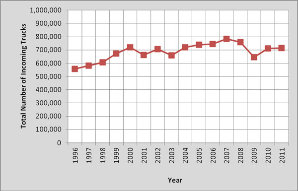
Following the implementation of the North American Free Trade Agreement (NAFTA), trade between the United States and Mexico increased substantially. Northbound commercial movements through El Paso–Ciudad Juárez gateways peaked at 782,000 trucks in the year 2007. While a slowdown in the US economy in 2008 (particularly in the automotive and housing segments) and international trade has reduced the number of US-bound trucks, the El Paso–Juárez metropolitan area remains one of North America’s largest manufacturing hubs. An estimated 6 percent of the US national economy crosses the border in the El Paso region.(3) Over the past decade, the overall growth of US-bound commercial movements between Ciudad Juárez and El Paso increased by more than 85,000 crossings during the first eight years but decreased over the last two years, so that there is a slight net decrease. These numbers are shown in figure 3.
http://www.bts.gov/programs/international/transborder/TBDR_BC/TBDR_BC_Index.html 4
Figure 3. Chart. Annual trend of US-bound truck movements through El Paso ports of entry.
El Paso – Juárez Port-of-Entry System
The El Paso–Ciudad Juárez metropolitan area is served by three international commercial vehicle crossings. The Santa Teresa/San Jeronimo, New Mexico POE is a land border crossing 11 miles west of El Paso. The other two commercial crossings, which are physically in the vicinity of El Paso–Ciudad Juárez, are the BOTA and Zaragoza–Ysleta POEs; both are international bridges over the Rio Grande River. No tolls are collected at the Santa Teresa or BOTA crossings; a toll is collected at the Zaragoza–Ysleta crossing.
The locations of these three ports are illustrated in figure 4.
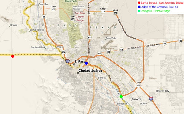
Figure 4. Map. El Paso area with commercial vehicle crossings.
Overall US-bound truck traffic at both commercial crossings in El Paso–Ciudad Juárez peaks between 10:00 AM and noon. During the early hours of the day, empty trucks cross US-bound through BOTA to pick up loads for maquiladora assembly plants. Even before BOTA closes for operation, some traffic voluntarily diverts to Ysleta, causing a period of high demand around 5:00 PM. Around 7:00 PM, loaded vehicles create another period of high demand at the Zaragoza–Ysleta crossing. These afternoon peaks result from shipments that leave Mexican maquiladora plants at the end of the second manufacturing production shift. There is significantly less crossing activity at the Santa Teresa POE throughout the day than at either the BOTA or Zaragoza–Ysleta POEs.
The Bridge of the Americas
The BOTA facility is located in the center of the El Paso–Ciudad Juárez metropolitan area, as illustrated in figure 5. The bridge is used for both commercial truck and passenger vehicle movements, and it has two separate structures–one for US-bound traffic and one for southbound traffic. Passenger vehicles and commercial trucks access the bridge via Cuatro Siglos (a street on the Mexican side of the border) and are directed to specific lanes by road signs in order to separate the two types of vehicular traffic using the bridge. Once on the physical bridge, trucks and passenger vehicles are separated by a concrete barrier. Truck traffic is handled by two dedicated outside lanes on each bridge structure. Local transportation companies funded the construction of a replacement bridge capable of handling commercial traffic in 1998.
Commercial freight accesses BOTA shortly after Boulevard Cuatro Siglos and Mexican Highway 45 merge, approximately ½ mile southeast of the physical bridge. Passenger traffic is diverted to Boulevard Ing. Bernardo Norzagaray at this point. Passenger traffic accesses BOTA from Avienda Abraham Lincoln, which runs north-south in Ciudad Juárez. After crossing the bridge, passenger vehicles have direct access to I-110, which links up with US Highway 54, I-10, and Loop 375. Commercial vehicles, after clearing the CBP and/or BSIF compound exit onto Gateway Boulevard North and enter the El Paso road system on East Paisano Drive, which provides access to US Highway 54.
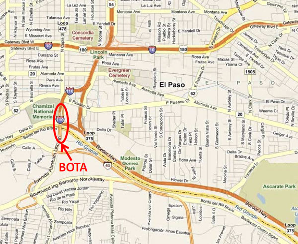
Figure 5. Image. Location of Bridge of the Americas.
US-bound Crossing Statistics
BOTA is the fifth largest commercial POE in the State of Texas in terms of number of US-bound trucks crossing. A list of the top ten POEs in the State of Texas for 2011 along with the number of US-bound trucks crossing at each POE is presented in table 1.
| Bridge | Number of US-bound Truck Crossings |
|---|---|
| World Trade Bridge | 1,327,479 |
| Pharr – Reynosa International Bridge | 452,821 |
| Ysleta – Zaragoza Bridge | 379,508 |
| Laredo – Colombia Solidarity Bridge | 374,781 |
| Bridge of the Americas | 337,609 |
| Veterans International Bridge | 177,986 |
| Camino Real International Bridge | 106,423 |
| Del Rio – Ciudad Acuna International Bridge | 62,966 |
| Progreso International Bridge | 42,605 |
| Free Trade Bridge | 30,773 |
Source: CBP
Figure 6 shows the numbers of US-bound crossings at BOTA in 2011, broken down by month.
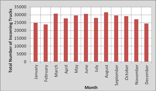
Figure 6. Graph. Monthly US-bound truck volume through BOTA in 2011.
Operational Characteristics
There are several key agencies involved in the border crossing process for US-bound commercial trucks at BOTA. These agencies include:
- US Federal Agencies - Customs and Border Protection, Federal Motor Carrier Safety Administration (FMCSA), U.S. Department of Agriculture, Drug Enforcement Agency.
- US State Level Agencies - Texas Department of Public Safety (DPS).
- Mexican Federal Agencies - Aduana (Mexican Customs).
The following describes the three principal facilities through which a US-bound truck will pass at BOTA:
Mexican Export Lot – A facility operated by Aduana (Mexican Customs) that is responsible for inspecting export materials leaving Mexico. Only a small percentage of freight is physically inspected at this facility for audit purposes.
US Federal Inspection Compound – This facility is operated by CBP. Its primary function is to make sure no harmful or illegal freight is permitted to enter into the United States. Secondary inspections can occur here if CBP feels it necessary to examine further the driver, freight, or conveyance. These secondary inspections can include intrusive measures (physically unloading the trailer to examine its cargo) or non-intrusive measures (x-ray or gamma ray imaging).
Border State Inspection Facility – The BSIF (a designation used by the State of Texas for this type of facility) is operated by the DPS. Its primary function is to ensure that tractors and trailers entering the United States from Mexico are safe enough to operate on US roadways. Secondary inspections of the vehicles can occur here if deficiencies are revealed through a preliminarily review of the conveyance by the BSIF. The FMCSA also has onsite representatives dedicated to ensuring the safety of trucks and trailers that would enter the United States.
The US-bound commercial freight border crossing process begins at the Mexican Export Lot on the south side of the border (also known as the Aduana facility). After clearing customs on the Mexican side, a truck crosses the physical bridge structure. Immediately upon entering the United States, the truck proceeds to the Federal Inspection Compound. Entrance to the Federal Inspection Compound is through one of six primary inspection booths. At these primary inspection booths, a CBP officer determines whether the truck requires any secondary inspection and if so directs the driver to it, or otherwise instructs the driver to proceed to the exit. The CBP officer will give final clearance to exit the Federal Inspection Compound at one of two booths at the exit of the premises, at which point whe truck proceeds on to the BSIF.
A one-lane access road that passes under US Highway 54 connects the Federal and State Inspection Facilities. Weigh-in-Motion sensors measure the weight of every truck that travels on this access road. Upon leaving the access road and entering the BSIF, trucks continue moving toward an inspection shed. Drivers of trucks departing the inspection shed are instructed by two overhead signs immediately after the inspection to either proceed to the exit of the facility (East Paisano Drive) or to secondary State inspection. If they are selected for secondary inspection, trucks will bear right after the inspection shed and loop back into the middle of the premises for further examination.
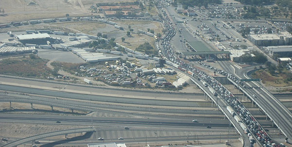
Figure 7 is an aerial view of BOTA, looking south across the Rio Grande river from El Paso, Texas.
BOTA operates from 6:00 AM to 6:00 PM Monday through Friday and from 6:00 AM to 2:00 PM on Saturdays. Empty truck traffic prefers using this free bridge to avoid paying the toll at the Ysleta–Zaragoza Bridge. Only trucks with empty trailers are permitted to cross between the hours of 6:00 AM and 8:00 AM. In 2003, one of BOTA’s two northbound lanes was converted to a designated lane for trucks whose carriers participate in the FAST Program. The FAST lane occupies the outside lane (the farthest right lane for US-bound traffic) on the physical bridge structure at BOTA.
2 http://www.elpasotexas.gov/city_manager/_documents/Presentation%20-%20Joyce%20AHMO%20Vitality%20of%20Border%20Regions%2010-26-06.pdf ↑
3 America.Gov Online, “US–Mexico Border Officials Balance Security, Commerce Needs,” September 24, 2007, http://www.america.gov/st/washfile-english/2007/September/20070924141658ajesrom0.7344171.html ↑
4 U.S. Department of Transportation, Research and Innovative Technology Administration, Bureau of Transportation Statistics, Border Crossing/Entry Data; based on data from US Department of Homeland Security, Customs and Border Protection, OMR database. ↑