Best Practices for Road Weather Management
Florida DOT Bridge Wind Speed Alerting System
The Florida Department of Transportation (FDOT) has deployed a high-wind alert system for road bridges. The system assists the transportation and public-safety communities by providing real-time wind speed status information during severe weather events from each monitored bridge structure. This information is used to assist transportation managers with bridge closure decisions.
Historically in Florida when a severe weather event occurs, such as a tropical storm, hurricane, or nor’easter, local law enforcement personnel must deploy to each bridge in advance of the weather event. The officer takes periodic wind speed measurements and reports the information to their local law enforcement agency which may eventually make the decision to close a bridge. This protocol puts law enforcement personnel in harm’s way unnecessarily and deploys them inefficiently precisely during a time when they may be needed elsewhere. Further, requiring them to make wind speed measurements with hand-held anemometers is not an accurate means of collecting meteorological data. There is also minimal dissemination of the pertinent wind speed data to local and regional public safety and transportation stakeholders with this protocol.
With the new FDOT wind alert system, these shortcomings will be addressed. The data is reliably collected from the system, and it is automatically and instantly disseminated to FDOT Regional Traffic Management Centers (RTMC) and to local public safety officials. All parties will have more accurate data from which to make informed decisions about critical issues like bridge closures and evacuation routes.
The system has been deployed on over twenty bridges in northeast Florida as part of a pilot project. All critical waterway bridges and interchange flyovers in this area of the state were instrumented. This included all barrier island bridges, most river bridges and the three major highway interchanges in the Jacksonville, FL area.
The reduced expenses associated with this project is due to the use of low cost wind-only detectors and solar-powered satellite transmitters that utilize a free telemetry service offered by the National Oceanographic and Atmospheric Administration (NOAA) called the Data Collection System (DCS). There is therefore no monthly reoccurring operational cost for the system (other than maintenance). The installation cost to instrument a bridge is approximately $10,000 (material and labor). FDOT is currently procuring satellite communications ground station equipment to enhance the dissemination of data to RTMCs state-wide.
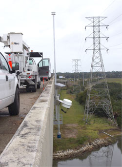
System Components: Each bridge is outfitted with a Data Collection Platform (DCP) that includes an ultrasonic wind sensor installed at approximately ten feet above the bridge road deck, as shown in Figure FDOT-1. The wind sensor connects to a data logger that performs analytics to discern wind gusts and continuous high winds. Multiple alarm thresholds are used to detect high wind conditions, triggering the data logger to transmit an alert message via a NOAA Geostationary Operational Environmental Satellite (GOES). The satellite transmitters are solar powered. The GOES transmits alerts to FDOT, where they can be disseminated via the FDOT statewide area network or via the Internet.
System Operations: Sampling of wind conditions is designed to maintain a low-power draw for the installation. Wind measurements are performed during one minute sample periods that are spaced ten minutes apart. Wind anomalies associated with passing vehicles are filtered out during this process, ensuring that only continuous winds and gusts are reported.
If the wind conditions trigger any of the multiple alarm thresholds, one or more alert messages are relayed via GOES to FDOT. Currently, FDOT is building two satellite communications ground stations to receive bridge wind alerts from GOES. Once received, those alerts are disseminated to the state-wide RTMCs. The main ground station is strategically located away from the coastline and next to a FDOT communications network hub. FDOT operates a redundant statewide area network over microwave and fiber links that provides a highly reliable connection to the RTMCs (these connections are 99.999% reliable, experiencing just 5 minutes of down time per year). This feature will help ensure that data is securely and reliably disseminated to the RTMCs even during severe weather events that may compromise commercial telecommunications infrastructures.
In the RTMCs computers will monitor the wind speed alerts and display them graphically on a map of the area. Alerts are received at the RTMC once wind speeds at any bridge reach thirty miles per hour (mph). Alerts continue to be received for each additional 5 mph incremental increase. The RTMC personnel can inform local public safety officials of each new alert condition on a bridge, giving law enforcement officers enough time to deploy and secure a bridge for closure. The system will also inform RTMC personnel when wind conditions are receding.
An additional software tool is being developed to provide authorized local public safety and emergency management personnel direct access to the wind speed data. FDOT is developing an Internet web application that will permit local officials to monitor the FDOT wind alert data securely over the Internet via dissemination from the NOAA ground station in Virginia. This secondary means of viewing the wind alerts will give hundreds of authorized public safety officials the ability to monitor local bridge wind speed conditions without compromising FDOT internal network performance or security.
Transportation Outcome(s): This new FDOT bridge wind speed alerting system will provide a more efficient, safe, and accurate method for collecting and disseminating information about potentially dangerous wind conditions on bridges. In addition, this new system will be able to share severe weather data with the FHWA and its Clarus initiative, as well as other agencies such as the National Weather Service.
One of the most significant benefits of this project is the low-cost way in which it was implemented. The use of the NOAA GOES system to collect wind speed alerts from the bridges will create a substantial savings on operational costs. For example, had FDOT used cellular telephone modems (a common approach) to communicate with the bridge DCPs, an eventual statewide deployment could cost the state $750,000 over five years, just for the cell phone bill. The use of solar panels saves even more money since running power lines to remote bridge locations is very expensive.
Implementation Issues: The installation of the bridge wind speed monitors required FDOT and its contractors to develop a mounting method that was performed quickly to minimize lane closure time, but also robust enough to withstand bridge vibrations and severe wind conditions. The location on each bridge was usually chosen to be the highest point, but also a point with a clear view of the southern sky so that the satellite transmitter could communicate with GOES. To avoid return visits to bridges to make installation changes, each bridge DCP was configured and initially tested on a rooftop Florida DOT test stand before being deployed.
Contact(s):
- Randy Pierce, Florida DOT Telecommunications Administrator, 850-410-5608.
- Peter Vega, Florida DOT District 2 ITS Engineer, 904-360-5463.
Reference(s):
- Florida DOT, Sunguide Disseminator Newsletter, October 2011. “A New Public Safety Focus for FDOT and ITS.”
- NOAA Data Collection System Website.
Keywords: wind, bridge, high wind warning system, public safety, emergency management, traffic management centers, advisory strategy, severe weather, hurricane, tropical storm, evacuation, high-profile vehicles, safety, satellite, NOAA, data collection system, data collection platform, sensor, solar-power.
previous | next