Synthesis of Active Traffic Management Experiences in Europe and the United States
3.0 US Techniques
As noted previously, ramp metering and managed lanes comprise the primary types of techniques currently under operation in the US that can be managed actively, with many metropolitan areas employing both ramp metering and managed lane facilities. Ramp meters are stop-and-go traffic signals placed at an on-ramp to control the frequency at which vehicles enter the freeway traffic stream. Managed lane facilities can include high occupancy vehicle (HOV), high occupancy toll (HOT), transit only lanes, and express lanes. They can be concurrent, contraflow or reversible lanes, whether operated part- or full-time.
3.1 Ramp Metering
Ramp metering, which maintains smooth freeway mainline flow by breaking up platoons of entering vehicles and/or limiting vehicle entry at entrance ramps, has been proposed and implemented in a number of metropolitan areas in and outside the US to mitigate freeway congestion due to merging vehicles.
The primary objectives of ramp metering include managing traffic demand to reduce congestion, improving the efficiency of merging, and reducing accidents—all of which lead to improved mainline freeway flow. In some situations, high volume freeway mainline flow can accommodate disbursed merging vehicles, but often cannot handle groups of vehicles at once. Ramp meters may control ramp traffic based on conditions in the field or manually to optimize the release of vehicles entering the freeway facility.
Ramp metering that is operated at pre-determined fixed-times of day is typically not considered an active management technique – while its operation can be demand based (on historical demand data), it does not manage the demand in a real-time active manner (It could be argued that even though a ramp metering system is set to start and stop at the same time every day, if it is actively monitored by operators and adjusted to adapt to conditions, and/or if the overall ramp metering algorithm is proactive in nature, then it could be considered actively managed). Ramp metering that employs or is managed using an adaptive algorithm that is based on system-wide monitoring that controls the application of ramp metering is considered an active management technique. Ramp meters that are monitored, activated and adjusted based on traffic operations by staff at traffic management centers would be considered actively managed, regardless of the algorithm used by the specific ramp meter.
The success of early ramp metering applications in US cities such as Chicago, Los Angeles, Minneapolis and Seattle led to the implementation and expansion of ramp metering systems in many other metropolitan areas in the US including Phoenix, AZ; Fresno, CA; Sacramento, CA; San Francisco, CA; San Diego, CA; Denver, CO; Atlanta, GA; Las Vegas, NV; Long Island, NY; New York, NY; Cleveland, OH; Lehigh Valley area, PA; Philadelphia, PA; Houston, TX; Arlington, VA; Miami, FL; and Milwaukee, WI; as well as in cities in other countries including Sydney, Australia; Toronto, Canada; and Birmingham and Southampton, UK.
In 2000 an independent study on ramp metering was conducted in the Minneapolis-St. Paul area (Cambridge Systematics, 2001). The evaluation addressed traffic flow and safety impacts associated with turning off all 430 ramp meters for six weeks. Results released by the Minnesota Department of Transportation showed that without ramp meters there was:
- A nine percent reduction in freeway volume.
- A 22 percent increase in freeway travel times.
- A seven percent reduction in freeway speeds, which contributed to the negative effect on freeway travel times. The reliability of freeway travel time was found to decline by 91 percent without ramp meters.
- A 26 percent increase in crashes, which was averaged for seasonal variations. These crashes broke down to a 14.6 percent increase in rear-end crashes, a 200 percent increase in side-swipe crashes, a 60 percent increase in “run off the road” crashes, and an 8.6 percent increase in other types of crashes.
While ramp metering is more prevalent in the US, it is also employed in Europe. Germany has noted that ramp metering effectively prevents the drop in traffic speeds normally associated with merges and allows for the harmonization of traffic flow on major controlled access roadways. Ramp metering was found to reduce crashes with person and property damage by up to 40 percent, with no negative effects on the adjacent roadway network. On highway A40, a test program from 1998–2002, showed a reduction in accidents of 55 percent, and a 65 percent reduction in severe accidents (translated from “Europe on Course—Telematics on German Roads” German Ministry for Transportation, Construction and Housing 2005).
3.2 Managed Lanes
A popular approach to mobility management in the US is managed lanes, which are defined as dedicated highway facilities or lanes in which operational strategies are implemented and managed. Many of the current strategies are not managed in real time, but with technology advances more real time applications are being considered and implemented. Managed lanes can facilitate traffic flow in response to changing conditions by controlling user eligibility, access and/or pricing. Traditional lane management strategies include high occupancy vehicle (HOV) lanes, high occupancy toll (HOT) lanes, express lanes and reversible lanes. Of the listed managed lane strategies, the only two that can currently be considered as “actively” managed are HOT lanes and express lanes that are dynamically priced.
This chapter includes a description of European traffic management techniques with specific examples from Germany, Denmark, the Netherlands, and the United Kingdom. Information, experience and data were highly variable in their availability and therefore, some management techniques are discussed in greater detail than others. All techniques described include a definition of the technique and an associated benefits assessment. When information was available for a given technique, information on operational and safety considerations was included as well.
The following European techniques are discussed:
- Speed Harmonization/Lane Control: dynamically and automatically reducing speed limits in or before areas of congestion, accidents, or special events to maintain flow and reduce risk of collisions due to speed differentials.
- Queue Warning: warning motorists of downstream queues and direct through-traffic to alternate lanes, to effectively utilize available roadway capacity and reduce the likelihood of collisions related to queuing.)
- Hard Shoulder Running: using the shoulder (inside or outside) as a travel lane during congested periods to minimize recurrent congestion. Hard shoulder running can also be used to manage traffic and associated congestion immediately after an incident.
- Junction Control: using variable traffic signs, dynamic pavement markings, and lane use control to direct traffic to specific lanes (mainline or ramp) based on varying traffic demand, to effectively utilize available roadway capacity and manage traffic flows to reduce congestion
- Dynamic Re-routing: changing destination signing to account for downstream traffic conditions
- Traveler Information: providing estimated travel time information and other conditions reports allowing for better pre-trip and in-route decisions
3.3 Speed Harmonization
Speed harmonization (also known as variable speed limits in the US) has been used in the Netherlands and Germany since the 1970s, where it is typically implemented on roadways with high traffic volumes, with a goal of improving traffic flow. In the Netherlands, speed harmonization has been used for many years for the purposes of creating more uniform travel speeds and managing traffic during adverse weather conditions. Lane control displays are used for mitigation of incidents, maintenance and construction. In Germany, approximately 200km (124 miles) of roadway are managed using speed harmonization and lane control. In Denmark, speed harmonization, also referred to as variable speed limits, is deployed to manage construction project-related congestion on the ring road around Copenhagen.
Figure 1 shows speed `harmonization signing in the Netherlands, while Figure 2 shows the Dutch signage application of the dynamic speed limit system in the Randstad area.
Figure 1. Speed Harmonization Signing in the Netherlands
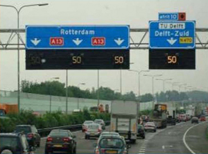
Source: Dutch Department of Transportation
In general, the European experience has been that at least one lane control display should be visible at all times for maximum effectiveness. In the Netherlands, gantries supporting speed controls are typically spaced an average of every 1,600 feet. In Germany, overhead sign bridge spacing is every 3,300 feet (1 km), but varies with installation and can extend farther, depending on sight distance. In addition to sight-distance and geometric considerations, cost may ultimately play a role in the spacing of lane control displays. Gantry spacing for the UK M42 motorway pilot project that implemented a combined speed harmonization and hard shoulder running installation was approximately every 1,600 feet (500 meters). Future UK managed motorway installations may ultimately consider a minimum spacing of approximately 2,600 feet (800 meters) and a maximum spacing of 3,300 feet (1000 meters) (UK Highways Agency Interim Advice Note 87/07, 2007).
Figure 2. Dynamic Speed Limits in Randstad Area
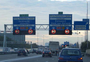
Source: Stoelhorst and Havermans Centre for Transport and Navigation, 2008
Lane control displays provide the flexibility to help manage incidents or address maintenance activities. When congestion is present, the speed limit is dynamically adjusted and displayed. When an incident occurs, a lane may be closed by showing a red ‘X’. Advance notice of an incident is usually provided by indicating to motorists that they should switch out of that lane. This is typically done by using a diagonal arrow pointing to a neighboring lane. In the Netherlands, when an incident occurs, they use a cocked arrow, followed by a red “X” to move drivers out of the lane. On the M42 motorway in the UK, lane control displays are typically enabled for four gantries upstream from the closure or incident, with the first indication being a reduction in standard operating speed, the second a further reduction in speed, and the following two gantries using cocked arrows to move drivers out of a closed lane(s).
Critical to success of speed harmonization is the traveler’s trust in the real-time operation of the system, including how it is being operated, its reliability, and the sense that it is being implemented for a valid purpose that will result in true safety and travel time benefits. Hence traveler information and in many cases queue warning are treated as crucial components for maximizing effectiveness of this technique. Operating the system on a 24/7 basis also generates public trust in the system whenever conditions warrant, and these conditions do not necessarily mean 24/7 staffing of the operation center.
Benefits Assessment
Germany has perhaps the longest history of speed harmonization projects, dating back to the 1970’s. Their experience has shown that speed harmonization results in lower accident rates and typically results in a modest (5-10 percent) increase in roadway capacity. This is accomplished in part because the variable speed limits decrease the likelihood of severe congestion by increasing the stability of traffic flow (translated from “Europe on Course—Telematics on German Roads” German Ministry for Transportation, Construction and Housing 2005).
When implemented in Germany on the A5 motorway between Bad Homburg and Frankfurt/West, speed harmonization was associated with a 27 percent reduction in accidents with heavy material damage and a 30 percent reduction in personal injury crashes (Sparmann, 2006). In Bavaria, accidents were reduced by up to 35 percent, with 31 percent fewer crashes involving injuries (translated from “Europe on Course—Telematics on German Roads” German Ministry for Transportation, Construction and Housing 2005).
In the Danish case, as a result of the traffic management applications implemented (speed harmonization, lane management and variable message system)—traffic loads on the surrounding streets were less than expected and accidents did not increase appreciably during the re-construction of the M3 Motorway, even though the existing roadway lanes were narrowed during the construction period (Wendelboe, 2008).
England has also applied speed harmonization, known locally as Variable Mandatory Speed Limits (VMSL). On M-42, speed harmonization with hard shoulder running resulted in a seven percent increase in capacity and less overall congestion over the 12-month study period. Statistically valid safety analysis requires three years of data, but the initial results are encouraging (Mott MacDonald Ltd., 2008).
Additionally, a number of countries have documented a reduction in vehicle emissions after the implementation of speed harmonization. In The Netherlands, local traffic emission reductions of NOx were in the 20 to 30 percent range and PM10 was reduced by approximately 10 percent in the four test locations. In the UK, initial results found that vehicle emissions were reduced between four and 10 percent depending on the pollutant, and fuel consumption was also reduced by four percent (Mott MacDonald Ltd., 2008).
Operations
In the UK, speed harmonization has been applied to the six-lane M42 motorway (three lanes in each direction) in the West Midlands near Birmingham. In locations where hard-shoulder running is also applied to the outside shoulder, speed harmonization is included for the hard shoulder lane as well. Speed harmonization in the three-lane sections is automatically activated based upon flow and speed thresholds, though operators may adjust the operation if required. In general, speeds are adjusted approximately three gantries (approximately 1,500 meters or nearly 1 mile) back from the area of reduced speeds or an incident.
Speed harmonization with hard shoulder running (four lanes) is also based on predefined flow and speed thresholds. However, activation is not automatic, since operators need to ensure that the hard shoulder running lane is not blocked by debris or stopped vehicles. When activated, the speed limit is 50 mph or less (Mott MacDonald Ltd., 2008).
Operations for the Washington State Department of Transportation (WSDOT) speed harmonization/queue warning system will be similar to the UK M42 motorway system in that the over-lane speed and lane control signs are automatically activated based on identified thresholds. Under normal congested conditions reduced speeds will be shown on the over-lane signs and reduced speed warnings and information will be provided via side-mount signs and traditional VMS approximately two gantries (1 mile upstream) from congested conditions. The gantry immediately preceding the back of the queue will display the lowest designated speed on the over-lane signs. Over-lane signs on subsequent gantries within congested conditions will be turned off and the shoulder-mount and traditional VMS will provide regulatory and informational messages as necessary. Under incident conditions that include a lane blockage, approximately four gantries upstream from the lane blockage will be employed to first reduce traffic speeds and then divert traffic from the blocked lanes.
Operations for the Minnesota Department of Transportation (MnDOT) intelligent lane control and variable speed limit system are generally similar to those discussed for the WSDOT system. Under normal congested conditions, two gantries prior to congested conditions will be engaged and five gantries prior to a blocking incident will be engaged, with the first two gantries displaying speed reductions and the remaining three displaying lane control information (Kary, 2009).
Enforcement and Compliance
Enforcement of the speed harmonization system’s reduced speeds in the Netherlands and England is automated. The automated speed enforcement system in the Netherlands measures average speeds over a two to three km (1.2 to 1.8 miles) section of the highway. In England, digital cameras are being used to record the license plates of violators who do not comply with the reduced speeds shown on the over-lane signs. Not all digital cameras are actively monitored at any one time, but the randomness of monitoring helps promote widespread respect among motorists. The threshold for what constitutes a speed offense is also random, based on the number of observed offenses so that only the worst offenders are cited.
Thus far, England’s experience on M42 near Birmingham illustrates high compliance with the posted speed limits using the Association of Chief Police Officers (ACPO) thresholds for enforcement. This threshold T is defined as being 10 percent higher than the posted speed S plus two mph, or:

Speed data were collected from January 2006 to September 2007 at 12 locations in each direction and analyzed applying the above thresholds for compliance with the posted speed limit. For speed limits of 50, 60, and 70 mph, compliance was 94 percent or better in all cases. For 40 mph posted speed limits, compliance was 84% or better. On the hard shoulder running lane, compliance was 97 percent or better at a 50 mph speed limit and 93 percent or better at a 40 mph speed limit (Mott MacDonald Ltd., 2008).
During the M42 pilot project study, surveys were performed to determine public awareness of signs and information. Each survey was split into two populations: local users and long distance users. Both groups had high (over 90 percent) awareness of the signs in the study section. However, they noted that some driver education is still necessary, particularly with the ‘lane ahead closed’ sign indicating that the lane was closing and drivers should therefore change to a neighboring lane. During 2007, a total of 25 percent of local users did not know the meaning of the sign (Mott MacDonald Ltd., 2008).
Capital, Operations and Maintenance Costs
Capital costs of speed harmonization can vary considerably by installation. This variance in cost is a result of the overall infrastructure approach to gantry/sign-bridge placement distances (1/4, to ½ to ¾, to 1 mile spacing), the number of lanes being spanned, the type of roadway that gantries/sign-bridges are being place on (at-grade or structure), the application of over lane, variable message and side mount signage, and the need for new or additional ancillary equipment (power, fiber optics, data feed, etc).
As an example of the difference in capital costs due to infrastructure, the M42 project in the UK is estimated in USD equivalent (USD equivalent based on 2008 exchange rates) per mile costs of approximately $18 million per mile (UK Department for Transport, 2008), which also includes the costs related to hard shoulder running. Whereas, the conceptual cost estimates for the Washington State speed harmonization/queue warning system were projected to range between $2.4 and $5.5 million per mile depending on the roadway segment (WSDOT, Active Traffic Management Conceptual Design and Cost Estimates, 2008). WSDOT developed an average conceptual cost estimate for a three-lane section of approximately $3.2 million per directional mile and approximately $4.0 million per directional mile for a five-lane section. It is important to note that the WSDOT costs do not include implementation of hard shoulder running.
As is demonstrated by the information above, capital costs for these systems can vary dramatically depending on the desired system, the inclusion of shoulder operations, signage requirements, gantry/sign bridge spacing, upgrades to ancillary equipment, and associated emergency refuge areas if desired. Therefore, it is critical to develop the overall system concept first and then determine the system requirements and operational approach to fully understand and estimate system costs. Operation and maintenance cost variances are due to the level to which existing traffic management systems are already employed along the roadway, the operational philosophy employed for the proposed speed harmonization system and finally the integration of speed harmonization facilities and operations into an existing traffic management center.
Queue Warning
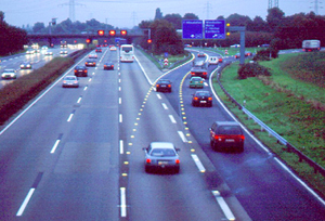
A key component of Germany’s speed harmonization system is the addition of queue warning. A congestion pictograph or icon is displayed on both sides of the gantries to alert motorists of congestion ahead (Figure 3). Alternatively, the pictograph may be displayed on an overhead DMS. The value of the system lies in being able to reduce the occurrence of incidents caused by the congestion.
Figure 3. Queue Warning—Side-Mount Congestion Icons
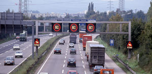
Source: Hessen, Germany
Queue warning systems are very frequently combined with speed harmonization systems given the large number of design elements they have in common. The Dutch system also incorporates queue warning in their speed harmonization system; motorists are alerted of downstream queues with flashing lights in addition to variable speed signs. As a result, there are few examples of queue warning systems operating in the absence of other traffic management strategies, which makes separate quantification of benefits and costs difficult.
Benefits Assessment
In Germany, the pilot project queue warning system was implemented on the A8 motorway between Stuttgart and Ulm. Positive results measured from the pilot included fewer accidents and reduced accident severity, a considerable reduction of high travel speeds, harmonization of all driving speeds, closer headways and more uniform driver behavior, and a slight increase in capacity, when compared to other motorways. In general, motorists were found to drive with greater caution due to the increased awareness of oncoming risks and downstream queuing. The result of this successful pilot has been its broader implementation across Germany and the inclusion of this strategy in the overall approach to managing congestion (Sparmann, 2006).
The Dutch have reported benefits of congestion warning (queue warning) in combination with speed harmonization in terms of a 15 to 25 percent decrease in primary accidents and a 40 to 50 percent decrease in secondary accidents from their safety assessments in 1983 and 1996, as well as an increase in throughput of four and five percent (Middelham, 2006).
3.4 Hard Shoulder Running
In Germany, hard shoulder running (also called temporary shoulder use) is applied with speed harmonization typically to address recurrent congestion and bottlenecks, but can also be deployed for non-recurrent congestion or incidents. This strategy allows for additional capacity during congestion and has been in use since the 1990s.
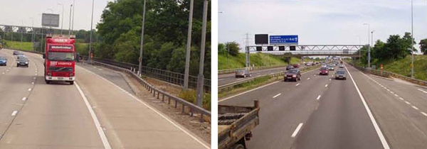
The Netherlands started using hard shoulder running in 2003 as part of a larger program to improve use of the existing infrastructure. The system on the M42 motorway in England utilizes the availability of the shoulder for travel rather than for emergency refuge only (Figure 4). To ensure its safe operation, additional emergency refuge pull-outs are spaced approximately every 1600 feet (0.31 miles) with emergency call boxes (Figure 5). Temporary shoulder use is almost universally deployed in conjunction with speed harmonization.
Benefits Assessment
In the Netherlands, implementing temporary shoulder use has had an overall capacity increase of seven to 22 percent by decreasing trip travel times from one to three minutes and increasing traffic volumes through the area up to seven percent during congested periods (Taale, 2006). In Germany, this technique has demonstrated a 20 percent increase in rush-hour capacity and reduced air and sound pollution along Munich area freeways (translated from “Europe on Course—Telematics on German Roads” German Ministry for Transportation, Construction and Housing 2005).
Figure 4. Hard Shoulder Running When Active and Inactive
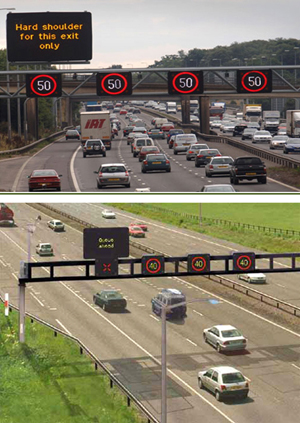
Source: UK Highways Agency
As described in the Scan Report (Mirshahi et al., 2007), temporary addition of a shoulder lane allows congested roadways to have higher throughput at reduced speeds, as indicated in Figure 6. However, the key to hard shoulder running is that the segment must extend through the roadway bottleneck. If it does not extend beyond the bottleneck, traffic is simply fed at a greater rate into the segment that is already over capacity, thereby compounding the congestion.
Figure 5. Emergency Pull-Outs Associated with Hard Shoulder Running
Source: Mirshahi, et al., 2007
Operations
In the UK the Highways Agency currently activates their speed harmonization system whenever hard shoulder running is in effect. The addition of the shoulder as a travel lane tends to increase speeds on neighboring lanes due to the sudden reduction in traffic density. There is some debate about whether or not there needs to be a limit imposed on the speeds during shoulder operating periods. Nonetheless, a conservative approach may be prudent for the initial implementation until post-implementation studies can be performed and analyzed.
Figure 6. Speed-Volume Relationship of Temporary Shoulder Use
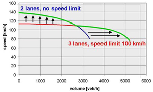
Source: Lemke and Irzik, 2006)
The hard shoulder running implementation in the UK currently only extends between major freeway interchanges (or junctions, as they are called in the UK). There is consideration underway of extending hard shoulder running through junctions where right-of-way and other considerations allow, but this approach has not yet been implemented. The initial plan calls for these through-junction lanes to be permanently open, as opposed to dynamic opening and closure as in traditional hard shoulder running (UK Highways Agency, 2008).
Safety and Design Considerations
Safety is generally the greatest concern when implementing shoulder-running strategies, since use of the roadway outside shoulder as a travel lane results in the loss of a continuous emergency refuge area for disabled vehicles and during incidents. Depending on the length of the hard shoulder running section, European examples suggest that the provision of infrequent paved emergency refuge areas or pull-outs should be considered during analysis and design of the affected segment. Alternative refuge areas would be outside of the shoulder area and would provide a designated place for stalled or disabled vehicles while allowing use of the hard shoulder as a travel lane (Figure 5). In England, the alternative refuge areas are spaced every one-third or one-fourth mile. Alternatively, Germany does not generally include refuge areas. Very short segments may not require a refuge area.
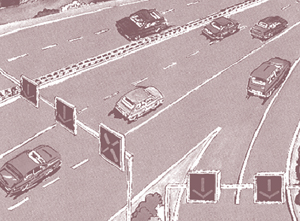
Pavement markings for the hard shoulder vary by installation and country as well. In Germany, the outside edge is not striped, which makes the lane appear more like a shoulder. However, in the Netherlands, the outside edge has a solid stripe, except in the emergency refuge area locations where it is dashed. This makes the shoulder appear more like a travel lane. Dynamic lane markings such as lighted pavement markers could be used to assist in delineating the travel lanes for motorists, especially for dynamic changes in ramp exits as shown in Figure 7.
Figure 7. Junction Control at an Exit with Hard Shoulder Running
Source: The Netherlands
Another safety issue relates to impediments in the shoulder (i.e., stalled vehicles or other debris) that needs to be cleared before opening the lane to use. The English approach requires a visual inspection of the shoulder before it is opened. This requires some intervention on the part of operators, which means that the system cannot be automatically engaged. Verification that the lane is clear of obstacles is completed via CCTV cameras for the M42 motorway system and for shoulder operation in Germany. Clearly, this requires strategic camera placement to ensure the affected shoulder is clear and can be opened for hard shoulder running.
In Germany, the Netherlands, and the UK, temporary shoulder use is typically implemented in conjunction with speed harmonization. In the Netherlands, additional traffic management and ITS treatments are used along with hard shoulder running to help mitigate any adverse safety consequences. These include (Helleman, 2006):
- Overhead lane signs;
- Emergency refuge areas with automatic vehicle detection (in-pavement loop detectors);
- Speed reduction during times of temporary shoulder use;
- Variable route signs at junctions;
- Advanced incident detection;
- CCTV surveillance;
- Incident management; and
- Roadway illumination.
3.5 Junction Control
A method to dynamically change lane allocation at an interchange is called Junction Control. It can be used at freeway off-ramps or on-ramps (Figure 7 and Figure 8); particularly for high volume ramps often associated with major freeway-to-freeway interchanges. The rationale for use is that in some traffic conditions or at certain times of day, it may be more effective to use existing downstream or upstream lanes for one type of movement or for traffic coming from the main lanes while at other times of day it may be more effective to use the through lanes for the ramp movement. For example, when ramp volumes are relatively light or mainline volumes are very heavy, it might be most effective to have an entrance ramp merge into the right lane. However, there may be times that the volume on the ramp is extremely high while the mainline volumes are low. In this case, traffic merging from the on-ramp will have to find gaps in the mainline traffic, despite the mainline traffic being relatively light. The delay caused by hesitation and time required to find a gap may be disruptive to ramp capacities and flows and thus, create a situation with higher rear-end collision potential on the ramp. Junction control is used to “close” the right lane of the mainline upstream of the ramp through the use of lane control signs in order to give ramp traffic a near free-flow onto the mainline. Junction control provides priority to the facility with the higher volume and gives a lane drop to the lesser volume roadway.
Figure 8. Junction Control On-Ramp Schematic
Source: Germany
Junction control can also be used at off-ramps, especially when hard shoulder running is used, to dynamically create a two lane off-ramp with a freeway drop lane and an option lane. Junction control is only advantageous at on-ramps when the mainline has spare capacity (giving priority to a higher merge volume). Similarly, junction control at an off-ramp is only desirable if an exit ramp has available width to accommodate an additional exit lane (giving priority to a higher exiting volume and/or downstream merging volume).
Benefits Assessment
In the Netherlands, a pilot junction control project at the Diemen interchange resulted in a reduction of overall mean travel times of seven and eight percent and reduced vehicle delay of four and 13 percent for both mainline and merging traffic, respectively (Helleman, 2006).
Operations
Junction control has been applied in Germany, typically at merge points or entrance ramps where there are a lower number of travel lanes downstream of the merge point. This requires the installation of lane control signals over the upstream and merging travel lanes, dynamically providing priority to the facility with the higher volume (Tignor, et al., 1999). The noted examples do not typically employ dynamic lane markings to match the changed merge conditions communicated by overhead signs, although this dual approach has been applied in the Netherlands.
3.6 Dynamic Re-routing
Dynamic re-routing involves directing motorists to take an alternate controlled access route within a regional freeway network, using either full-matrix dynamic message signs or rotational prism guide signs. The signs change with traffic conditions to provide information regarding queues, major incidents, and alternate routes.
In Germany, the use of dynamic re-routing information is a critical component of their ability to meet their national goal, which is to serve 80 percent of all trips on the motorway network using real-time traffic and traveler information by 2010. In the Netherlands, dynamic route information has been provided since 1990, currently utilizing over 100 gantries to display informational panels across the country on major motorways. Figure 9 shows a dynamic route sign in the Netherlands (Middelham, 2006).
Figure 9. Dynamic Route Information in The Netherlands
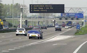
Source: Middleham, 2006
A hybrid sign can also be used for dynamic re-routing. A static sign comprises the major portion of the sign, but the route shields and destinations are changeable within the fixed sign panel, such that they can direct motorists to take the alternate route. These hybrid signs are typically located over the affected lanes approaching an interchange. For the normal “through” route, the shields and destinations are deactivated (changing the shield and destination part of the panel to background blue or in the case of US implementation, green) or displaying route closure notification in the same space. Meanwhile, the exit or diverging ramp sign includes the alternate route shield with downstream destinations. Algorithms are applied to properly display the route diversion on all affected downstream signs, and can be automated or manually activated from a traffic control center. Dynamic re-routing typically addresses only the most prominent or strategic routes within a freeway network. Dynamic re-routing may also be employed with junction control to help manage traffic in a variety of contexts. For example, if junction control is used to provide additional exit lanes and reduce through lanes at a particular junction, dynamic re-routing could be used to divert through traffic to parallel routes. Similarly, junction control can also support dynamic re-routing by providing additional capacity to a particular movement that has been targeted for re-routing.
Benefits Assessment
The ability of this technique to divert up to 40 percent of through-traveling vehicles was shown on Nuremberg area freeways in Germany, leading to reduced travel times and emissions (translated from “Europe on Course—Telematics on German Roads” German Ministry for Transportation, Construction and Housing 2005). The Dutch have estimated a five percent improvement in overall system performance associated with dynamic re-routing (Middelham, 2006).
Compliance
The driver compliance rate increased on German freeways when a reason for the re-routing was given in addition to the alternate route information (translated from “Europe on Course—Telematics on German Roads” German Ministry for Transportation, Construction and Housing 2005). Assessment studies completed by the Dutch indicate that between eight and 10 percent of drivers comply with the changed route information (Middelham, 2006).
3.7 Traveler Information
The Germans, Danes, and Dutch successfully employ traveler information to increase roadway efficiency and performance. In Germany, the traffic management centers (TMC) serve a critical role in disseminating information to roadway users about incidents, congested conditions, and other events or situations that may impact operations. The TMCs use the traffic data to change speed, lane usage, and route guidance information. One of the methods of informing drivers is to use rotational prism guide signs that change with traffic conditions.
In Denmark, the Traffic Information Center (TIC) was established in 1982 in a joint effort with a private company to provide traffic reports on morning radio news programs. The TIC covers all of Denmark and operates 24 hours a day, seven days a week. Traffic-related data is acquired from a number of sources, such as law enforcement, counties, municipalities, private citizens, private companies, transportation agencies, traffic reporters, road sensors, monitoring cameras, and weather stations. The TIC disseminates information in a variety of ways to reach the largest number of potential users.
Benefits Assessment
Traffic information systems in Germany have proved effective, especially when integrated with other traffic management systems (translated from “Europe on Course—Telematics on German Roads” German Ministry for Transportation, Construction and Housing 2005).
3.8 Summary
There are a number of traffic management techniques that can be applied on a spot basis, a roadway basis and on a system-wide basis to positively affect overall roadway and system operations. The application of combined set of traffic management techniques at the system-wide level is a considerable undertaking, but one that can yield considerable operational benefits and system-wide efficiencies.
All countries discussed in this report have or are implementing or expanding a variety of traffic management techniques. However, the UK is perhaps approaching the concept of traffic management on a system-wide, multimodal basis most fully by embarking on their managed motorways approach, which strives to manage the entire roadway system and other modes interfacing with the roadways as efficiently and effectively as possible using multiple management strategies. In this sense, the UK is approaching the concept of Integrated Corridor Management that has recently been discussed in the US, in which management strategies are applied to an entire travel corridor (freeway, ramp systems, transit facilities and parallel arterials) to best utilize all transportation facilities, regardless of facility type or jurisdiction, within a travel-shed.