Chapter 5: Transportation Needs During Activation and Operations
Successful transportation during evacuations depends on careful planning. This is important when evacuating special needs populations, as the type of vehicle provided can expedite or complicate evacuations. Collaboration between providing agencies is critical, as response vehicles may be mustered from a variety of public and private agencies. Communication serves a critical role in successfully transporting special needs populations, including communication between drivers and dispatchers, between responding agencies, and between the public and responders. Use of intelligent transportation systems (ITS), where available, may enhance response as well. ITS can provide critical real-time information to evacuees and those transporting them, which may reduce the amount of time spent in evacuation operations.
Mobilizing Vehicles and Vehicle Operators
Response plans at agency and jurisdictional levels should include clearly stated procedures for mobilizing vehicles and vehicle operators. Mobilization should occur using pre-planned lists of agencies, drivers, vehicles, and other personnel and resources required for special needs evacuation operations.
Providing agencies or companies and vehicle operators should be notified as far in advance as possible to ensure they will secure their homes and families prior to service in the emergency event. They also need time to prepare people with special needs and to arrange shift assignments and alternates with their staff.
It has been reported that transportation personnel had a difficult time volunteering to drive buses because family evacuations were not provided for; prior planning was not fully considered; and in some cases, essential personnel were not clearly identified. [38] Two weeks after Hurricane Katrina hit New Orleans, Mayor Nagin stated on Meet the Press:
“Sure, there was [sic] lots of buses out there, but guess what? You can’t find drivers that would stay behind with a Category 5 hurricane, you know, pending down on New Orleans. We barely got enough drivers to move people on Sunday, or Saturday and Sunday, to move them to the Superdome. We barely had enough drivers for that. So sure, we had the assets, but the drivers just weren’t available.” [39]
Staging areas with clear access and egress for staff and vehicles should be designated in plans. However, if they are not viable at the time of the operation, alternatives should be considered. Arrangements for food, water, or EMS should include directed delivery to the staging area. Enough supplies should be ordered to accommodate the needs of drivers, mechanics, and other staff. Additional staff required for evacuation assistance should be simultaneously mobilized and assigned to drivers and vehicles.
Staging area staff will brief transportation operators and assistants on routes, shelter locations, anticipated traveling conditions, and the needs of evacuees (including the presence of service animals or specialized or heavy equipment) so that each route is run as efficiently as possible.
Dispatch and Tracking
Mobilization for rapid-onset events may occur under unfavorable conditions. As a result, communications with operators, dispatchers, and evacuees is needed to ensure that passengers are prepared and waiting in appropriate locations and that operators are fully aware of their assigned routes. Passengers will need to know information such as pick-up locations, what they need to bring with them, and accurate information on the disaster. For more information on communicating with special needs passengers, see Chapter 4.
An essential line of communication is between dispatchers and drivers. Dispatchers should keep track of the following, in addition to other needs as determined through local planning:
- Driver names and contact information
- Vehicle information (owner, number, license plate, type, capacity, etc.) and assignment
- Route maps
- Locations of fuel and emergency vehicle repair facilities
- Contact information for interpreters and translators
- Evacuee information (where available through evacuation registries)
- Contact information for liaisons and other people and agencies that will provide critical, up-to-date information
- Names and contact information for people assisting with evacuations (e.g., mechanics, personnel at fuel depots, staging area workers, assistants traveling with vehicles).
Accurate lists of people working during the evacuation should be maintained to ensure the safety of all responders. Tracking is also necessary to ensure each vehicle is returned in proper condition to the owner and each responder is properly credited with work.
Passenger manifests should also be provided to the dispatcher or another entity to enable immediate tracking of those being evacuated. In this way, the driver will not be the sole holder of the manifest, allowing for back-up information. Although it is important to recognize that passenger manifests are resources, it is also important to be aware of confidentiality issues and sensitivity regarding the information in the manifest. Passenger manifest sharing should be done when necessary and as appropriate between agencies.
FEMA is developing a National Mass Evacuation Tracking System (NMETS). NMETS is an open source database system designed to track the movement of people, pets, bags, and medical equipment. The single national system can assist state and local agencies in tracking the movement of evacuees and provides additional modules to support congregate care facility management. The system requires enrollment of the evacuee prior to transport. The evacuee receives a barcode bracelet that can link him/her to traveling companions, service animals, household pets, and medical equipment.
In the event of an evacuation, Texas evacuees will be registered on site and issued a bar-coded RFID wristband. An evacuee’s wristband will be scanned by the GDEM with a wireless device as the evacuee boards a state-contracted vehicle, and the information will be added to the bus boarding log. Evacuee intake information and location will then be sent wirelessly to the data center at the University of Texas Center for Space Research. Vehicles will be equipped with a Global Positioning System (GPS) to track the vehicle’s location along the evacuation route. Upon reaching the destination, the SNETS will update evacuee profiles and provide real-time information. This will enable the state to respond to inquiries from the public about evacuated family members and reunite them. [40]
Operations: Evacuation and Re-entry
Evacuation and re-entry operations will be similar in the way drivers and passengers are mobilized and coordinated. Drivers and dispatchers must be aware at all times of roadway closures and restrictions resulting from hazardous conditions and changes to shelter locations and capacities. This can be addressed through normal agency procedures or via a designated liaison to dispatchers to provide current and timely information. On the federal level, ESF-1 handles this coordination.
Re-entry will include the clearance of vehicles into areas as allowed by law enforcement. Dispatchers must maintain current roadway conditions, weather updates, and/or other emergency information to prevent the return of people into hazardous areas. Particular attention should be given to electric and other utility outages, as persons with disabilities may be dependent on those services for daily medical needs. This information should be provided through normal channels as determined by local emergency management structures. See Chapter 8 for further information on re-entry.
Field checklists placed in each vehicle or at staging areas can be used to guide the evacuation and re-entry processes, particularly when new operators are being used or when plans are being executed for the first time. Checklist items may include, but are not limited to, the following:
- Driver identification (ID)—name, contact information—and credentials
- Location of staging areas
- Location of vehicle keys and back-up keys
- Emergency contact for drivers and format (e.g., Citizens’ Band [CB] radio, push-to-talk, emergency frequencies for radio communication)
- Dispatch contact and alternate
- Route maps and alternate route maps
- Lists of evacuees per vehicle with contact information
- Shelter locations and types (e.g., general population, special medical needs, pet-friendly)
- Specialized equipment required (e.g., wheelchair lifts, foreign language information)
- Fuel locations
- Instructions for breaks and shift changes
- Local information sources (e.g., 211/511 systems, highway advisory radio [HAR])
- Point-of-contact for rumor control (to verify road closures or shelter changes that may be announced by the media or purported by evacuees)
- Worksheets for trip times (departure and arrival); mileage; passenger names and counts; driver name, company, and contact information; staging areas; pick-up points; and shelter locations. Detailed records must be kept for any potential cost reimbursement.
Critical to the success of mobilization and operation are current information and clear instructions. For a sample worksheet on record keeping for trips, refer to Annex 4.
Using ITS in Evacuations of People with Special Needs
ITS includes vehicle and infrastructure technologies used to collect and distribute transportation-related information among vehicles, the roadway, the environment, transportation system managers, and system users. Generally, ITS applications are not usually discussed in emergency management plans. Despite this lack of focus, these tools can aid system administrators, emergency personnel, and evacuees during a mass evacuation. [41]
In planning for disasters and evacuations, ITS can be used to identify transportation system vulnerabilities and aid in the development of countermeasure strategies. During an evacuation, officials can use ITS to collect real-time data related to current roadway conditions and to monitor evacuation progress. [42] These applications may be used to facilitate communication and direct resources and to aid in evacuations by timing traffic signals, approximating travel times, and providing detour information. To maximize the benefit of ITS tools, the system should be extended throughout the evacuation route to the sheltering point. ITS can also be useful in assisting re-entry after a disaster to help guide returnees home via the best route. [43]
While ITS applications can be useful under certain conditions for evacuation planning and execution, agencies incorporating ITS into an evacuation plan must be aware of the limitations of ITS. Many technologically advanced ITS applications depend on electricity and wired communications. Natural disasters have the potential to leave ITS tools inoperable due to power outages, communications disruptions, and even damage to the equipment. Installing applications with independent power sources such as solar cells and wireless communications such as Wi-Fi or WiMax can improve system performance during a disaster but cannot ensure system operability. [44]
The following describes some of the most common ITS tools and their use in aiding those evacuating people with special needs.
Traffic Management Centers (TMCs) and EOC
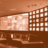 TMCs can serve as the transportation-specific operations center for all incoming ITS information. The EOC or even the staging area can use this information to facilitate communication with emergency workers. Sometimes, the two centers are located within the same facility. However, most often, these facilities are linked electronically or through transportation liaisons to the EOC who are familiar with how to obtain, analyze, and interpret transportation data. Transportation agency and emergency personnel at the TMC or EOC may use data collected at TMCs to make real-time evacuation decisions and monitor progress, including decisions that will aid in the evacuation of elderly and disabled persons. [45] Information from cameras and traffic counters monitoring roads around hospitals, nursing homes, and other such facilities can be used to better route vehicles providing evacuation assistance to these facilities. These applications can help determine where incident response and removal may be required and provide overall travel time information. [46] The TMC’s effective management of available capacity reduces the potential for operational failures, which can cause gridlock, long hours of delays, vehicle breakdowns, frustrated travelers, and significant risks to the evacuees. [47]
On August 1, 2007, a bridge collapsed on I-35W in Minneapolis, Minnesota, and there was an interest in how the city’s Wi-Fi network could be used to support the emergency response. According to w2i Digital Cities’ James Farstad, “Immediately following the collapse, city emergency and community communications centers were flooded with incoming alerts from witnesses to the tragedy. In the 90 minutes following the event, the city’s 911 Emergency Communications Center handled more than 450 calls. Its 311 Non-emergency Communications Center logged over 600 contacts. Cellular carrier systems in the region were overloaded within 30 minutes.” Numerous other potential applications of the wireless network were identified including “opening an alternate path to electronic communication and information for city personnel; extending the Wi-Fi network infrastructure to fully blanket the scene of the bridge collapse for emergency personnel on-site connectivity; implementing live multiple perspective camera coverage of the scene for EOC and Command Post uses; and providing community links to City of Minneapolis resources, Hospital Emergency Coordination Units, State of Minnesota Department of Transportation traffic routing information, Red Cross Blood Bank collection points, and local and national news outlets.” [48]
Cameras/Closed Circuit Television
Closed-circuit television (CCTV) provides an advantage over loop detectors by allowing officials direct visual confirmation of traffic and weather conditions, sometimes including a multiple perspective camera view of major traffic arteries for TMC staff. This technology can assist transportation personnel in closing roads determined to be unsafe and developing appropriate rerouting. [49] Such information could be transmitted to those vehicles transporting evacuees with special needs to reduce delays and the time the evacuees spend being transported to a shelter, alternate nursing home location, or other such facility. CCTV also provides a secure means of linking the centers of operation during an evacuation including the TMC, EOC, public safety, fire department, and shelters. When connected to a wireless network and operating under their own power, these CCTV signals open a path to electronic communication and information for evacuation managers even if other municipal functions shut down. [50]
Variable Message Signs (VMS)
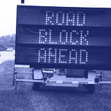 VMS, also known as changeable message signs (CMS) or dynamic message signs (DMS), are electronic road signs that display messages to systems users. VMS can be permanent fixtures or portables devices, displaying either a preprogrammed message or one programmed in real time. The signs can display travel times, locations of traffic incidents, or locations of shelters for evacuees. [51] VMS are especially helpful to hearing-impaired evacuees who are unable to hear radio announcements or information from 211/511 systems. [52] VMS are usually controlled from the TMC, so coordination with the TMC staff will be necessary if the EMA wants messages posted regarding the evacuation or re-entry.
Traffic Counting Devices
These devices are installed into the roadway to count the number of vehicles on the road. Data from these devices can be used to provide emergency personnel with the quickest route to and from evacuation sites and shelters, especially when transporting people with special needs. Permanently installed traffic counters can supply data to one or more locations, generally a statewide, regional, or local transportation agency. Information can also be sent into the TMC and can be shared with the EOC. It is important to note that there is sometimes a delay associated with the devices supplying the traffic count data back to the collection point. This is primarily due to the type of communications system used to transmit the data. However, even with such delays, this is often the most up-to-date information available on traffic volumes during the evacuation. In addition, it is useful to have a redundant communications system in the event the primary system is inoperable. Since not all communities have installed permanent traffic count stations, historical traffic count data collected manually can aid planners in estimating roadway conditions during the evacuation.
Traffic Control Devices
These devices can help transportation managers to maximize evacuation efficiency by enabling designated vehicles to move more freely on otherwise gridlocked roads. While such devices can assist all evacuees, they are especially useful when transporting people with special needs to avoid medical emergencies, rapidly transfer trauma patients, and other such functions that reduce the duration of the evacuation. Traffic control devices include:
- High occupancy vehicle (HOV) lanes/bus-only lanes can allow buses and other vehicles to transport people with special needs to shelters quickly in order to return and pick up more passengers.
- Pavement markings can designate specific evacuation lanes or lanes that are designated for emergency vehicles.
- Interconnected traffic signals decrease the time that evacuating vehicles spend waiting for green lights by synchronizing traffic signals, thereby increasing traffic flow. An optimal signal pattern for an evacuation scenario can be created in advance for quick implementation during an actual event. Additionally, like cameras and other ITS applications, independent power sources can be installed on traffic signals to allow for continued use during a power outage.
- Traffic signal pre-emption are devices on some traffic signals that allow an approaching emergency vehicle to change the traffic signal timing pattern to allow them to proceed unimpeded through the intersection.However, the use of such devices may disrupt the major direction of traffic flow during an evacuation, so their use during that time must be carefully considered.
- Ramp meters are traffic signals installed on highway entrance ramps to control the flow of traffic by allowing vehicles to enter the highway in a uniform manner.
- Ramp gates are deployable gates on highway entrance/exit ramps that prevent traffic from entering or exiting the highway at that point. These can be especially useful if a reverse flow lane is being utilized.
- Reversible lanes allow for an increased traffic flow in a particular direction. Some highways are designed to accommodate reversible traffic on a daily basis, such as during daily rush hour periods or special events. Utilizing these extra lanes can increase the available throughput volume of traffic during an evacuation.
In addition to planned reversible lanes, transportation agency staff can decide to reverse the direction of all inbound lanes, even further increasing the number of vehicles exiting an evacuation area. While possible, this practice should only be implemented in situations where additional roadway capacity is required. Measures to keep vehicles from entering the lanes further up the road must be taken, and there must be a detour return route for municipal and emergency vehicles. However, if an otherwise non-reversible lane is reversed, ITS applications such as cameras, CCTV, and loop detectors can assist in the coordination. Such traffic control devices are owned and operated by transportation agencies at the state and local levels. It is important that these agencies be represented in evacuation planning and operations so they can make the adjustments necessary to the traffic control devices to support the evacuation and re-entry.
Traveler Information
Traveler information systems vary from HAR with limited broadcast ranges to speech-activated automated phone services available to users to provide route-specific traffic, weather, and shelter information such as available transit services and expected travel times and evacuation duration. [53] HAR services may be provided by fixed or portable radio systems, and messages may be easily changed for various conditions and language needs. Before or during a disaster, evacuees can dial a pre-designated number on a landline or cellular telephone to get traveler information. Information may be specific to the jurisdiction or agency operating the service, such as sheltering information via ARC services (as in certain locations in Florida) or evacuation route information from state and local governments. The availability of traveler information services varies widely, with most locations not offering substantial detail at present. Each service provides limited options for the deaf and hard-of-hearing, and alternate information or TTY services should be considered in addition to traditional services. It is important to keep in mind that jurisdictions may have different call numbers. Some cities like New York City maintain a non-emergency general information number (311) that may provide information for evacuees. Such a system allows the 911 number to remain open for emergency calls.
The southeast Florida, Central Florida, and Tampa regions under the Florida Department of Transportation implemented 511 systems where users can obtain information about congestion, travel times, and road closures. A separate hotline provides information on hurricane shelters. Florida also makes its state and regional 511 services available online, allows users to customize its 511 information including travel trips for specific routes, and will present customized information when calling 511 via caller ID. [54] Generally, a state or local transportation agency maintains these 511 systems. Emergency managers should coordinate with the appropriate agency to provide the content for any recorded messages as well as real-time information to be provided on these 511 systems.
Service Patrols [55] (Traffic Incident Management [TIM] assets)
Service patrols can be transportation workers or contractors under agreement with the state transportation agency who are dispatched to support law enforcement, fire, and rescue personnel in addressing traffic incidents. They may be used along evacuation routes to mitigate or rapidly address incidents and maximize traffic flow. [56] While they serve an important purpose to the general public, including directing traffic and providing fuel for motorists, these patrols can be especially helpful to evacuees who need assistance. Other ITS applications can be used to ensure that service patrols can operate effectively and efficiently during an evacuation. This could include using cameras and CCTV to provide service patrols with real-time information and taking advantage of reversible lanes, shoulder use, and special signal control strategies to allow them to quickly move within the evacuation zones. [57]
Service patrols are generally operated by state and/or local transportation agencies either with their own staff or through a contract. Service patrols are generally found in major urban areas, although some do operate on a limited basis in more rural areas. Service patrol vehicles travel a certain route or geographic area and assist motorists in need. The TMC maintains contact with service patrols and can dispatch them to a particular location to respond to a specific need such as a traffic crash observed via the TMC’s CCTV cameras. For an evacuation, the service patrol vehicles may be stationed along the evacuation routes at certain intervals so they can quickly respond to an incident such as a vehicle needing fuel, fixing a flat tire, or other minor repairs. Providing these services can help to move disabled vehicles out of the traffic stream to allow other evacuating vehicles to pass. To provide information to decision makers considering establishment of a service patrol, FHWA published a Service Patrol Handbook in November 2008.
[38] Litman (2006) Lessons from Katrina and Rita: What Major Disasters can Teach Transportation Planners
[39] Litman (2006)
[40] Wise Research Ltd/Using RFID, “Texas to Use RFID to Manage Citizen Evacuations.” December 11, 2007.
[41] FHWA, Using Highways During Evacuation Operations for Events with Advance Notice.
[42] W2i, Minneapolis Bridge Collapse Provides Early Test of Wi-Fi Network.
[43] FHWA, Using Highways During Evacuation Operations for Events with Advance Notice.
[44] Ibid.
[45] National ITS Architecture Team, Disaster Response and Evacuation.
[46] FHWA, Using Highways During Evacuation Operations for Events with Advance Notice.
[47] National ITS Architecture Team, Disaster Response and Evacuation.
[48] W2i, Minneapolis Bridge Collapse Provides Early Test of Wi-Fi Network.
[49] National ITS Architecture Team, Disaster Response and Evacuation.
[50] W2i, Minneapolis Bridge Collapse Provides Early Test of Wi-Fi Network.
[51] FHWA, Using Highways During Evacuation Operations for Events with Advance Notice.
[52] CalSILC, CA Wildfires for People with Disabilities.
[53] Florida Elder Affairs, Disaster Preparedness Guide.
[54] Florida Elder Affairs, Disaster Preparedness Guide.
[55] Service patrols will have different names around the country (e.g., incident management assistance patrols or courtesy patrols).
[56] National ITS Architecture Team, Disaster Response and Evacuation.
[57] National ITS Architecture Team, Disaster Response and Evacuation.