Technologies That Complement Congestion Pricing—A PrimerA Menu of Technology OptionsThere is a range of technologies that comprise an intelligent infrastructure that actively monitors and manages transportation assets. Such technologies are applied by transportation agencies to anticipate, manage, and intervene in the operation of the transportation system to sustain the safe and efficient movement of people and goods. What follows are the types of technologies that are most commonly used for managing freeways and arterial highways, transit systems, and commercial vehicles. These are technologies that can vastly extend the benefit derived from a congestion-pricing approach. Influencing Travelers En RouteTravelers already on the transportation network can be influenced towards other routes and modes to avoid higher tolls at peak times, congestion, or traffic-impeding crashes. En route information has the potential for redistributing demand and maximizing available capacities across all available facilities. Dynamic Message SignsA widely applied technology for en-route–traveler information is through dynamic message signs (DMS). DMS also can be applied to describe the congestion pricing for using a particular facility. For example, DMS can show the dynamic price for vehicles that do not meet the occupancy requirement in order to use the high-occupancy toll (HOT) lanes along I-95.2 Understanding this cost can motivate a traveler to explore or continue to use other travel options, such as rapid transit. Perhaps most visibly, over 40 metropolitan areas in the United States already use DMS for providing travel time information along highway segments. The effective application of DMS can prepare a traveler to decide on taking a diversion route if there is some incident or construction activity downstream. Full-Matrix SignsFull-matrix signs spanning the roadway can be effective in emulating a guidance sign, but with the added benefit of changing into various guidance signs to promote positive progression as vehicles continue to their destinations. This is beneficial for dynamic routing to divert motorists toward unfamiliar routes to circumvent congestion. Several assessment studies have indicated that under normal conditions, between 8 and 10 percent of motorists adhered to the route information, and network performance improved by 5 percent. Germany applies full-matrix signage to perform dynamic routing based on measured traffic conditions and incidents. Influencing Travelers Pre-TripEngaging travelers before they begin their trip offers the best chance of influencing their overall travel. Providing real-time status of all available travel options, plus tools for planning the travel, can motivate travelers toward fewer congestion-inducing choices and provide the information needed by travelers who wish to avoid paying higher toll rates that may be charged during peak times. Web-Based Traveler InformationWeb-based traveler information provides an on-demand service for travelers who seek information on toll rates, alternative modes, and traffic and travel conditions. This type of approach is most common for pre-trip traveler information, in which a traveler may plan a route and compare monetary costs and travel times for various travel options. Travelers can access a complete range of real-time multimodal transportation information at home, work, and other major sites where trips originate. Based on this information, the traveler can select the most cost-effective departure time, route, and modes of travel, or perhaps decide not to make the trip at all. Many traveler information Web sites in the United States and abroad enable this convenience, most notably in San Francisco (e.g., www.511.org) and the United Kingdom (e.g., www.transportdirect.info). 511 Telephone-Based Traveler InformationThe Federal Communications Commission (FCC) established the 511 dialing assignment specifically for the purpose of providing telephone-based traffic and travel conditions information. Since 2000, over 40 systems have been established across the United States, with some systems covering entire States and others covering only specific urban areas. A 511 Deployment Coalition of States was established to provide guidelines to promote consistency of the service and its interface. Although 511 is aimed toward delivering pre-trip traveler information, studies indicate that travelers use 511 for en-route information when they experience unusual congestion from a crash or some other lane-blocking event. Transit Traveler InformationTransit traveler information is critical for encouraging passenger-car commuters onto transit vehicles. To accomplish this, transit information needs to provide not only transit schedule and fare information, but also compelling transit reliability. Now that the Web is being used increasingly at transit locations, transit providers can offer real-time information about arrival times at transit-vehicle stops. This encourages ridership, because travelers can directly integrate the transit schedule with their personal schedule. An example of this approach exists in the New York City area’s Trips 123 tool (www.trips123.com), which offers trip-planning tools that consider real-time transit status. Influencing Personal BehaviorAdvances in telecommunications and information technology make it possible to highly influence individuals. Directly targeted information gives individuals the widest perspective for making their trip choices, or not traveling at all. In-Vehicle Traveler InformationIn-vehicle traveler information is widely available through much of Europe, several nations in Asia, and in America’s largest markets. A component of Germany’s real-time traffic and traveler information program is the Radio Data System–Traffic Message Channel (RDS-TMC), which is broadcast on commercial and public FM stations. These RDS-TMC signals are received on in-vehicle global positioning satellite (GPS) and navigation units and relay route conditions and routing information that may not be displayed through DMSs. Many automotive manufacturers now install these receivers in their vehicles. In the United States, providers such as Tom Tom, XM NavTraffic, and Sirius Traffic broadcast similar location-based traffic conditions in the largest urban markets. Targeted Traveler InformationPersonalized traveler information that is conveyed directly to the traveler is common in many regions. Examples include alerts via text messaging to mobile phones and email alerts that describe impediments to travel, the price schedule for the congestion pricing scheme, and the anticipated travel times. Often a traveler can define filters that enable tailored information to be delivered at specific times or when an anomalous event occurs. The sophistication of technology that pushes information to individuals is growing rapidly, particularly with location-aware mobile phones that can accept information specific to the traveler’s location. TeleworkTelework, or telecommuting, enables one to choose no transportation mode at all. In essence, some trips to work can be avoided by moving the work to the worker. Not all activities can be satisfied through telecommuting; however, pollution reductions have been demonstrated through aggressive marketing of telecommuting to employers. Influencing Vehicle Flow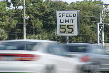
Variable speed limit sign deployed on I-4 in Orlando, Florida. Managing the supply of roadway capacity helps to delay the onset and magnitude of congestion. Regulating the flow of vehicles onto a freeway has been demonstrated to improve the travel performance for all travelers. With congestion pricing of a freeway, price signals are used to reduce demand during peak times and to prevent a breakdown of traffic flow. However, demand tends to vary from day to day, and it is difficult to set toll rates to perfectly match the variations in demand. Complementary strategies, such as ramp metering and variable speed limits, can help moderate flows on days when toll rates are not perfectly matched to demand. Variable Speed LimitsVariable speed limit (VSL) signs are both regulatory and dynamic and establish a new speed limit that suits the prevailing flow conditions. VSLs can be applied to provide speed progression in which a sequence of VSL signs display incrementally reduced speed limits along a highway section. This has the effect of gradually slowing the progression speed of vehicles over a longer distance. The effect of applying VSL in this manner is reducing sharp variances in speed in a short length of roadway, thus reducing a causal factor in rear-end collisions that impede overall flow. Speed variance reduction was observed in the implementation of VSL in several European cities.3 Germany observed a 30-percent reduction in personal injury crashes. The Netherlands applied VSL to help reduce carbon emissions in sensitive areas and observed a 16-percent crash reduction while increasing throughput by 5 percent. Ramp MeteringRamp metering has been demonstrated in numerous metropolitan areas throughout the United States, and it has been proven effective for reducing travel time and improving travel speed. The implementation of ramp metering for a variably priced-lane facility rests with stabilizing the entry of vehicles to the non-managed lanes and preserving free flow for as long as the capacity permits. The residual benefit is smoother operation for the variably priced lanes, which may become sensitive to capacity breakdown conditions in the non-managed lanes. An evaluation of ramp metering in Minnesota revealed dramatic results.4 When the meters were shut down, traffic volumes on the freeway mainline were observed to decrease by 9 percent, there was no appreciable change in the volumes on the parallel arterials observed, and freeway speeds were reduced by 14 percent (i.e., 11.9 km/h; 7.4 mi/h), resulting in greater travel times that more than offset the elimination of ramp queue delays. Moreover, when the meters were shut down, there was no appreciable change in the travel times on the parallel arterials, travel times were nearly twice as unpredictable, and crashes on freeways and ramp segments increased by 26 percent. Special-Use Ramp Management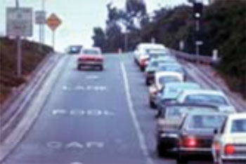
Special-use ramp management. Special-use ramp management treatments include strategies that give “special” consideration to a vehicle class or classes to improve safety, improve traffic conditions, and/or encourage specific types of driving behavior. The most popular special-use ramp management application is the designation of high-occupancy vehicle (HOV) bypass lanes or ramps. Designation of HOV bypass lanes and ramps limit use of these facilities to only those vehicles with multiple occupants in an effort to reduce overall freeway delay. Adaptive Signal ControlAdaptive signal control continuously monitors arterial traffic conditions and the queuing at intersections and dynamically adjusts the signal phasing to accommodate the broadest free flow for all approaches. The adjustments to the signal timing could be influenced by counting those vehicles that are equipped for the variably priced roadway and by extending the green phase; thus, these vehicles could enter the limited access facility more quickly. As an alternative, the adaptive signal control can detect high-capacity vehicles, such as those in Bus Rapid Transit, and adjust the signal timing for those vehicles as well. For more information, please visit the FHWA Every Day Counts – Adaptive Signal Control Web site. Lane ControlsLane controls establish restrictions on speed and use for specific lanes, such as dynamic shoulder travel lanes. They may also be used on regular lanes to ensure safety when dynamic shoulder lanes are in use for travel. By using lane controls with dynamic shoulder travel lanes, the structural width of the roadway can be fully utilized for periods of the day when there is a capacity demand. Enabling this temporary travel lane is valuable for older facilities in which there is a limit on available space for a permanent travel lane. If a single lane on an existing facility is under consideration for conversion to a variable-priced lane, the remaining general-use lanes can be augmented for specific periods of the day using lane controls. This would enable the opportunity to maintain a level of service for the flow of the general-use lanes and to minimize the impedances for congested flow on those general-use lanes upon the variably priced lane. Alternatively, all lanes could be used as priced lanes during peak periods. Lane controls could be used to harmonize speeds on all lanes. In case an incident causes blockage of any particular lane, lane controls could be used to direct motorists away from the blocked lane(s) upstream of the incident location. In case of incidents, lane controls may also be used to reserve at least one “open” lane for use by high-occupancy vehicles and for those other vehicles willing to pay a premium toll. Automated Vehicle Location for TransitAutomatic vehicle location (AVL) systems calculate the real-time location of any vehicle equipped with a GPS receiver. Data are then transmitted to the transit center through radio or cellular communications and are used immediately to correct scheduling and other operational deviations. Data can also be archived and used for schedule and route planning, reporting, and performance analysis. Successful AVL and computer-aided design implementation can reduce fleet sizes by 2–5 percent. The Maryland Transit Administration reduced its fleet size in Baltimore to meet the same level of service, resulting in savings of $2–$3 million per year. |
|
United States Department of Transportation - Federal Highway Administration |
||