| <<Previous | Contents | Next >> |
Road Weather Information System
|
|
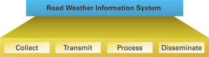
Figure 1. Road Weather Information System (RWIS)
Functions |
This document focuses primarily on the ESS, the "collection" component of the RWIS shown in Figure 1. These guidelines are intended to help establish uniformity in siting ESSs and to improve the usefulness of road weather information derived from ESS observations. Future revisions to this document may be necessary as environmental sensor technology evolves and research on the characteristics of the roadway environment is completed.
The document is designed to provide siting criteria that satisfy as many road weather monitoring, detection, and prediction requirements as possible. The criteria are based on an analysis of published documents on the siting of weather and pavement sensors, and the results of interviews conducted with nearly two dozen road weather experts representing State Departments of Transportation (DOT), equipment suppliers, and consultants. The individuals interviewed are acknowledged in Section 7 of this document. Roadway and transportation professionals, transportation agencies, researchers, ESS vendors, and meteorologists supporting the transportation community will be able to use these guidelines to aid in siting ESS equipment. The guidelines contained in this document do not represent standards for agencies or vendors to follow, but instead offer a set of recommendations.
Section 1 of this document serves as an introduction, providing the scope and purpose and defining the concept of the ESS as it applies to the guidelines that follow. This section also highlights some of the key benefits of employing RWIS ESSs as part of an Intelligent Transportation System (ITS). Section 2 establishes the ground work for deploying an ESS by helping the DOT planning team assess road weather information requirements. To help decide what sensors to deploy as part of the ESS, Section 2, supplemented by Appendix C, provides an overview of the road weather information elements that may be of interest to road operations and maintenance personnel and how these elements can be measured or detected. Additionally, Section 2 differentiates between regional and local ESS sites and discusses the siting criteria of each. Section 2 also encourages the formation of partnerships to share weather observing and road weather resources. These partnerships offer an opportunity to reduce the number of required ESSs and the cost of gathering road weather information. Section 3 builds on the previous section to recommend guidelines for selecting the ESS site and suggests tools to help make siting decisions. Section 4 provides recommendations for siting the ESS tower and individual sensors. Section 5 addresses some additional considerations to include power, communications, safety, security, and ESS metadata. Appendix A contains Acronyms and Definitions while Appendix B contains a list of References in the document. For easy reference, a checklist based on the recommendations in this document is included in Appendix D.
This document provides a set of guidelines to encourage uniform siting criteria designed to help improve the accuracy and usefulness of road weather observation data. There are several compelling reasons for uniform siting guidelines:
While there are many previously established guidelines for siting weather observing equipment,1,2,3,4 there is limited published siting information,5,6 specifically for the roadway environment. The guidelines in this document are designed to fill that gap and to improve the usefulness of road weather information specifically for the surface transportation community.
An ESS consists of one or more sensors measuring atmospheric, pavement, soil, and/or water level conditions. ESSs can be installed in situ within or along a roadway, or on a vehicle. This document only addresses stationary, in situ sensors.
|
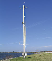
Figure 2. Road Weather Information System (RWIS) Environmental Sensor Station (ESS) |
Figure 2 is an example of an ESS with multiple sensors located on Route 528, the Beeline Expressway, near Cape Canaveral, Florida.
|
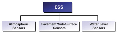
Figure 3. Environmental Sensor Station (ESS) Categories |
Figure 3 shows the ESS sensor categories that provide information to identify roadway weather conditions of interest. ESS data are collected in a remote processing unit (RPU) and transmitted to a central processor. Resulting road weather information is used to activate automated warning systems and provide decision support to managers in traffic management centers, road maintenance facilities, and emergency operations centers. By monitoring road conditions using pavement sensors or video, operations and maintenance personnel are able to assess how well their traffic management or winter maintenance strategies are performing, or to determine what additional actions are required. Conditions of interest include pavement condition (e.g., wet, snowy, icy, flooded, plowed), pavement chemical concentration or pavement freeze-point temperature, pavement temperature, soil (sub-surface) temperature, air temperature, wind speed and direction, precipitation, (e.g., amount, occurrence, type), humidity, atmospheric pressure, radiation (solar and terrestrial), and visibility. Atmospheric sensors are located above the roadway level and can be used to identify conditions such as strong cross winds or in combination with pavement/subpavement sensors to identify conditions such as icy roads. Some ESSs include water level sensors that are deployed in flood prone areas and on coastal roadways. While not commonly included as part of an RWIS ESS, auxiliary sensors, such as lake webcams and riverbed scouring sensors, can provide opportunities to add sensors that can help monitor and detect events resulting from water-related conditions.
|
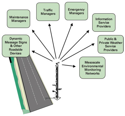
Figure 4. Environmental Sensor Station (ESS) Operational Applications |
ESS data provide many benefits, in addition to improving road safety, mobility, and productivity, by supplying information on roadway conditions essential for traffic operations, traveler information, road maintenance, and emergency response. Figure 4 identifies several additional operational applications.7 Benefits derived from these applications include:
To maximize these benefits, an attempt should be made during the planning process for siting RWIS ESSs to contact other organizations involved in similar data collection that may help both local transportation agencies and other customers (e.g., NWS; Federal Aviation Administration (FAA); U. S. Forest Service (USFS); local TV stations; universities and high schools; and, other city, county, and state agencies). Section 2.3 discusses the potential for establishing information partnerships and/or leveraging the data collected by other organizations. The Siting Checklist at Appendix D provides a reminder to the siting team to consider information partnerships during the siting process.
1 World Meteorological Organization: Guide to Meteorological Instruments and Methods of Observation, Sixth Edition, WMO-No. 8, 1996.
2 Office of the Federal Coordinator for Meteorology - Services and Supporting Research. Federal Standard for Siting Meteorological Sensors at Airports. FCM-S4-1994 August 1994.
3 US Environmental Protection Agency. Meteorological Monitoring Guidance for Regulatory Modelling Applications. EPA-454/R-99-005 February 2000.
4 US Department of Interior, National Wildfire Coordinating Group. National Fire Danger Rating System Weather Station Standards. March 2003.
5 Boselly, S.E., J.E. Thornes, and C. Ulburg. Road Weather Information Systems Volume 1, Research Report. Strategic Highway Research Program Publication - SHRP-H-350, National Research Council, Washington D.C., 1993.
6 Boselly, S.E., and D.D. Ernst. Road Weather Information Systems Volume 2, Implementation Guide. Strategic Highway Research Program Publication - SHRP-H-351, National Research Council, Washington, D.C., 1993.
7 Goodwin, L., Best Practices for Road Weather Management, Version 2.0, prepared by Mitretek Systems for the FHWA Road Weather Management Program, May 2003.
| <<Previous | Contents | Next >> |