Alternate Route Handbook
5. Alternate Route Plan Development
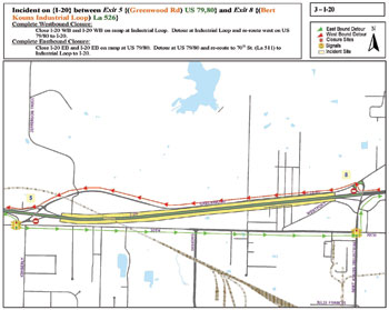 |
| Figure 5-1. Sample alternate route plan. (Source: Northwest Louisiana Council of Governments) |
INTRODUCTION
The second phase in the alternate route planning process involves alternate route plan development. The following three steps facilitate plan development:
- Determine alternate route plan content.
- Develop alternate route plan implementation guidelines.
-
Develop guidelines for discontinuing alternate route plan implementation.
DETERMINE ALTERNATE ROUTE
PLAN CONTENT
After stakeholders select the alternate route, they must determine the information to include in the alternate route plan. The area type and scope of the alternate route plan influences the level of information to be included on the alternate route plan. Table 5-1 describes the possible roles of each stakeholder involved in determining alternate route plan content.
Minimum Actions for Determining Alternate Route Plan Content
The task of determining alternate route plan content involves the following minimum action: use a paper or electronic map to illustrate the alternate route plan. Associated considerations include:
- Some agencies, rather than creating original maps, use an existing map (either a paper map or an electronic map) to indicate
(either with ink or electronically) the selected alternate route. Text describing the alternate routes should also be included. Concurrence should be sought to ensure that adequate information, to effect rapid plan implementation, is provided in the alternate route plan.
- The alternate route maps must clearly
illustrate the selected alternate route and direction of travel. In addition, it should include the location of mainline closure on the primary route.
- If color-coded routes are used on the map, then there should be some other feature (such as line weight) used to differentiate the routes. Since alternate route plans will often be photocopied, for use in the field, it is important that the routes can be clearly deciphered when shown in black-and-white.
Table 5-1. Stakeholder involvement in determining alternate route plan content
| STAKEHOLDER |
ROLE |
| Transportation/public works agency |
- As the lead agency, set up meetings for the alternate route planning process.
- Provide most of the traffic-related information for roads that traffic is diverted from in addition to roads that are used as alternate routes.
- Develop alternate route plans.
- Provide responder (dispatch) contact information for inclusion in the alternate route plan.
|
| Law enforcement |
- Provide input regarding its duties and responsibilities during alternate route implementation.
- Outline implementation activities, including equipment and personnel deployment, in the alternate route plan as agreed to by all participating stakeholders before the plan is finalized.
- Provide decision criteria for ranking law enforcement officials that may serve as the Incident Commander at the scene.
- Provide responder (dispatch) contact information for inclusion in the alternate route plan.
|
| Fire department |
- Provide input regarding when alternate route implementation will occur relative to critical response actions (e.g., incident stabilization, treatment of injured persons) that must take place at the incident scene upon responder arrival.
- Provide decision criteria for ranking fire officials that may serve as the Incident Commander at the scene.
- Review and approve the alternate route plan before the plan is finalized. The fire department should provide responder (dispatch) contact information for inclusion in the alternate route plan.
|
| Emergency medical service |
- Provide input regarding when alternate route implementation will occur relative to critical response actions (e.g., treatment and transport of injured persons) that must take place at the incident scene upon responder arrival.
- Review and approve the alternate route plan before the plan is finalized.
|
| Turnpike/toll authority |
- Provide most of the traffic-related and operations information for toll roads shown on the alternate route plan.
- Develop alternate route plans for toll road facilities.
- Provide responder (dispatch) contact information for inclusion in the alternate route plan.
|
| Planning organization |
- Share knowledge about an area as a whole that could help provide valuable information in an alternate route plan.
|
Ideal Actions for Determining Alternate Route Plan Content
The following ideal actions may be applied in addition to the minimum action:
- Create detailed alternate route maps. Associated considerations include:
- If available, GIS software is ideal for creating alternate route plans. A separate layer may be created for each feature. GIS software generally provides the capability of assigning a specific line weight or line pattern, in addition to color, for various features. Because a map with too much information can become cluttered, GIS allows response maps specific to each agency to be created, showing only the information that is needed by that agency. Also, different levels of implementation (e.g., long-term versus short-term) can be indicated on different layers.
- Composite maps should be printed on paper and saved in an easily accessible format (such as a portable document format file) for quick reference. Concurrence should be sought to ensure that adequate information, to effect rapid plan implementation, is provided in the alternate route plan. Information that should be included on an alternate route plan map is:
- Limits of closure on main road.
- Alternate route, including arrows showing direction of traffic if the route is used one-way only.
- Location of all traffic signals and associated jurisdiction (State, county, local), as shown in figure 5-2.
- Location of other traffic control devices, such as ramp meters and lane control signals, supporting alternate route operations.
- Location of CMS and permanent/temporary trailblazer signage supporting alternate route operations.
- Stationing locations of law enforcement and other personnel involved in providing traffic control during plan implementation. Figure 5-3 shows an alternate route plan that specifies locations where law enforcement must provide traffic control.
- Roads and ramps (e.g., freeway entrance ramps upstream of the incident site) that are closed, including the location of primary route closure for which the alternate route applies.
- Number of lanes on alternate route.
- Geometric information (e.g., turning radius and length of curves and ramps), as shown in figure 5-4.
- Speed limits.
- Ownership of roads.
- Roadway pavement type, as shown in figure 5-5.
- Background traffic volumes.
- Background vehicle composition (e.g., percent heavy vehicles, buses).
- Parking prohibitions.
- Height and weight restrictions.
- Locations of police stations, firehouses, hospitals, schools, major traffic-generators.
- Photos or drawings of trailblazer signs to be used during implementation, as shown in figure 5-6.
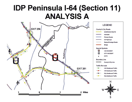
- Figure 5-7 shows a detailed alternate route plan for an urban area. Figure 5-8 shows a detailed alternate route plan for a rural area. Figure 5-9 shows a detailed alternate route plan that includes both freeway and street alternate routes. Note that not all alternate route plans will necessarily include all of the above-listed information.
- Each map should be assigned an index number. An index map makes it easy for responding personnel to find the appropriate alternate route plan map based on the location of primary route closure. It should show the limits of primary route closure for each alternate route plan map in the set. In order to facilitate creation of the index map, it is important to assign an index number to each plan in the set.
- Include detailed information on the alternate route plans on how to implement the alternate route. Associated considerations include:
- Alternate route plans should include detailed information on the duties of each stakeholder involved prior to, during, and after the implementation of the alternate route. Flowcharts and tables are ideal for this purpose. In addition, contact information should be included for pertinent response personnel. Figure 5-10 shows an example flowchart for implementing special traffic signal timing plans during alternate route operation.
- An alternate route checklist should be incorporated so that appropriate signage, including CMS message sets and traffic control devices, are deployed when the alternate route plan is implemented. Figure 5-11 shows an example of an alternate route checklist.
- Contact information for all agencies, within the area covered by the plan, that may participate in plan implementation should also be included in the alternate route plan. Contact information should include both office and off-hours (remote) contacts. Figure 5-12 shows an example of an agency contact matrix.
- All stakeholders involved in alternate route plan implementation should review the plans to ensure that (1) the information presented is accurate, (2) they understand their roles and responsibilities, and (3) they have sufficient resources to fulfill their roles and responsibilities.
- Include maps showing the location of all supporting ITS equipment. In addition to alternate route plan maps, it is often useful to include a map showing the location of permanent ITS equipment (see figure 5-13). Pertinent ITS equipment shown includes (1) information dissemination equipment, such as CMSs or HARs, (2) surveillance equipment, such as detectors or closed-circuit television cameras, and (3) traffic control equipment, such as ramp meters. These maps are useful both for planning alternate routes as well as for reference when the alternate route is being implemented.
- Supplement alternate route plan maps with written directions. At times, written directions confirm map specifications and may be easier to follow than graphic instructions included on a map, particularly if the plan has been photocopied or faxed.
- Include a traffic signal timing plan. The alternate route plan should include the modification of the traffic signal timing to accommodate the additional traffic volume (see figure 5-14). The plans should clearly indicate for each intersection the cycle length and the green time split assigned to the alternate route.
- Include a traveler information plan. Associated considerations include:
- If traveler information devices, such as CMS or HAR are used, a plan showing sample message sets should be included. Ideally, messages should be planned for all scenarios covered in the plan set. Figure 5-15 shows an example of a CMS plan, and figure 5-16 shows an example of a HAR plan.
- The plan should include protocol for media outreach, both for peak periods and off-peak periods. Broadcasters may routinely include traffic reports during morning and afternoon peak travel periods, but special announcements may have to be made during off-peak periods.
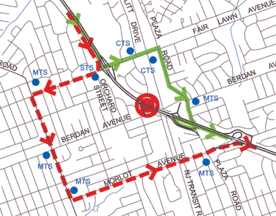
MTS = Municipal traffic signal
CTS = County traffic signal
STS = State traffic signal |
| Figure 5-2. Specification of traffic signal jurisdiction on an alternate route plan.
(Source: New Jersey DOT) |
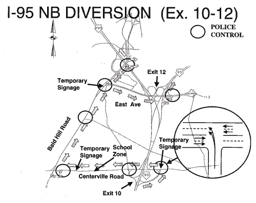 |
| Figure 5-3. Alternate route plan showing law enforcement traffic control locations. (Source: Rhode Island DOT) |
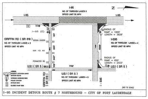 |
| Figure 5-4. Alternate route plan showing interchange and intersection details. (Source: Florida DOT District IV) |
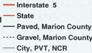 |
| Figure 5-5. Legend showing ownership and roadway pavement type. (Source: Marion County, OR, Department of Public Works) |
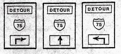 |
| Figure 5-6. Graphic of trailblazers included in an alternate route plan. (Source: City of Dayton, OH, Police Department) |
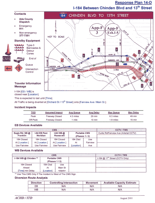 |
| Figure 5-7. Detailed alternate route plan in urban area. (Source: Idaho Transportation Department) |
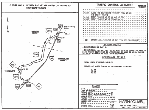 |
| Figure 5-8. Detailed alternate route plan in rural area. (Source: North Carolina DOT) |
 |
| Figure 5-9. Alternate route plan showing freeway and street alternate routes. (Source: Virginia DOT) |
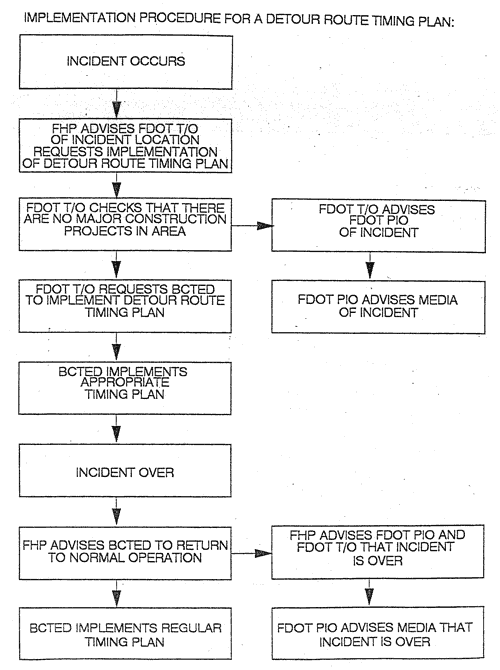 |
| Figure 5-10. Implementation flowchart. (Source: Florida DOT) |
(Chapter 5 is continued on next page.)
|