
|
||
4.4.3 Integration of ITS Elements in the RegionIn this section we detail how the ITS elements outlined in the previous sections could be integrated. Some of the integration described in this section is currently done; the subcommittees developed other interactions as possible ways the elements could be integrated in the future as different ITS systems come on line. The Transportation Management Committee began to look at these interactions by considering them on a macro or system-wide scale. It is at this point where the ITS National Architecture came into extensive use for this process. The committee began by using the ITS National Architecture's overall summary diagram, also known as the sausage diagram. Figure 22 illustrates the National Architecture's macro view of all the possible interactions between ITS elements. Note that the ITS National Architecture contains four different possible entities for information connection: centers, travelers, vehicles and roadside elements. Boxes within these four centers are called subsystems. 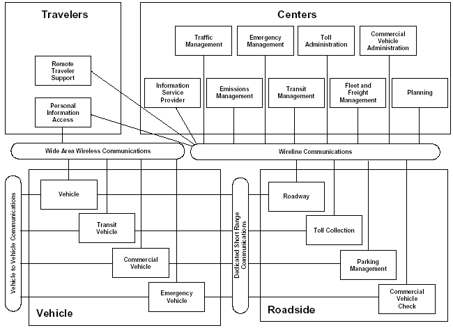
The Transportation Management Committee's first task was to tailor this diagram to reflect central Ohio current and future implementation (Figure 23). Below is a table developed by the Transportation Management Committee that illustrates the ITS elements – current and planned – in central Ohio.
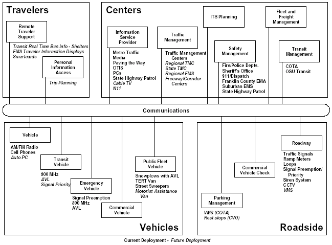
Note how the regional stakeholders involved in this process have eliminated some of the subsystems used in the ITS National Architecture and listed under each subsystem examples of local applications. However, at this level of resolution, understanding any of the detailed interactions between these entities is difficult if not impossible. Therefore the Integration Study next developed Functional Flow Diagrams to understand the interactions in more detail. These Functional Flow Diagrams were based on the Market Packages from the ITS National Architecture, but expanded and modified for local use. Those very familiar with the ITS National Architecture will note that beyond the macro view illustrated above, the committee significantly modified the way to present the detailed interactions between these ITS elements. Functional Flow Diagrams are, simply put, diagrams of the pieces that are required to implement a particular transportation service. They are tailored to fit real world transportation problems and needs. It was MORPC's goal to make this Integration Strategy for central Ohio as understandable as possible, and for this reason much of the jargon-rich language of the ITS National Architecture was replaced with, hopefully, easier to understand terms. Figure 24 illustrates how to read a Functional Flow Diagram. 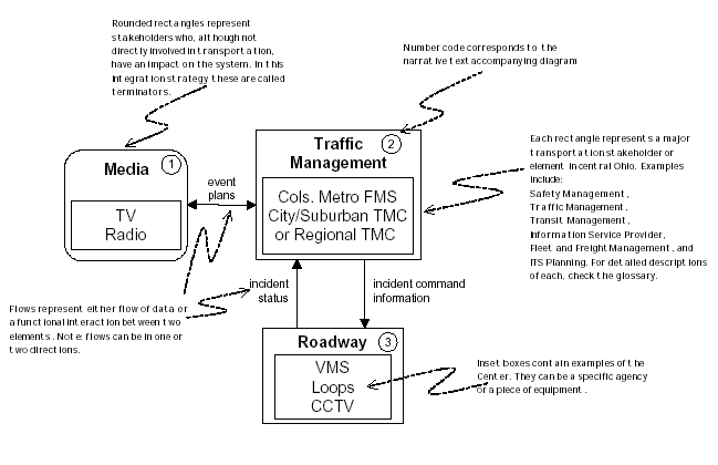
Through these diagrams, MORPC and the committee were able to map out the interaction (current and future) between ITS elements in the region. All boxes in the Functional Flow Diagrams are numbered and correspond to numbered paragraphs found in the text below them. The following sections are divided along loose functional areas:
|
||||||||||||||||||||||||||||||
| US DOT Home | FHWA Home | Operations Home | Privacy Policy | ||||||||||||||||||||||||||||||