2.0 Technical Approach (Page 1 of 2)
2.1 Disadvantages of Manual Collection
The process of getting data collectors onsite and ready to go at a border crossing is detailed and expensive. The collection itself can be physically challenging. There are a number of areas in which automating the process of data collection would offset current disadvantages. Permanent or semi-permanent vehicle sensing technologies, capable of operating in inclement weather, would be an attractive alternative to the current labor-intensive process.
Sovereignty Issues
While Canada and Mexico are friendly nations, getting permission to operate on their soil is not trivial, even with NAFTA. In all cases, data collectors must have the absolute approval of Customs and Immigration. That approval must include provision for being in that nation as well as on the premises of their facilities. Formal, time-consuming paperwork is often required. Any equipment installed in Mexico or Canada would need written approval also, but its continued operation would generally be on a non-recurring basis. Conversely, on-site personnel typically have to have written permission or passes from one or more agencies for each visit.
Other Approvals
Crossings that have bridges may have private authorities, (such as Ambassador Bridge at Detroit-Windsor), who own and operate the bridges and whose approval is required while on their property. Toll operations may be conducted by a national agency (as in Mexico), a city (as in Laredo and El Paso), or an authority (as Ambassador Bridge). Their approval is also required.
A host of additional approvals may be needed, including national or state police, the General Services Administration (GSA) or its equivalent across the border, local municipalities, local law enforcement agencies, and consulates. Even with close communications, data collection can easily get disrupted if knowledge of the agreed arrangements hasn't reached all the right people in Customs, Immigration, GSA or other on-site organizations. Some of these agencies are large and it is important to ensure that every key person knows what has been orchestrated.
Logistics
In the majority of cases, data collectors have to travel an appreciable distance to reach the site. That involves airfare, rental cars, lodging and meals, labor, shipment of equipment, and sometimes out-of-country auto insurance.
Safety
While this has not been a problem to date, there is no question that operating in the vicinity of a stream of tractor-trailers whose drivers are on tight deadlines requires collectors to be constantly aware of their surroundings. A secondary issue is personal security. While data collectors are generally in the vicinity of Customs operations, some may have to venture to remote locations to stay ahead of a queue. This situation can introduce new and unexpected traffic conditions. Or the collector may find that the area does not appear to be in a particularly safe neighborhood.

Figure 1. Data Collectors Have To Make Safety the Top Priority
Weather
Temperatures along the Mexican border can easily top 100 degrees F. The Canadian border can be hot as well, but rain – particularly in conjunction with cool temperatures – can be challenging to the data collector on the Canadian border. Of course, the Canadian crossings have very cold temperatures during the winter months, but ice and snow would affect many of the sensing technologies as well. Some of the collection points experience high winds, and the data collectors may be exposed to wind-driven grit generated by passing trucks. In fact, data collectors in El Paso experienced dust storms at the Zaragoza Bridge crossing at El Paso-Juarez during the 2001 truck travel study, at which time visibility dropped rapidly. The effectiveness of sensing technologies can also be reduced by weather, particularly fog, ice, and snow.
Limited collection times
Data collectors must arrive at pre-determined times. The process of scheduling those times must take into consideration national holidays on both sides of the border. It must identify the periods that are most conducive to actual collection of limited data. It must ensure that all necessary approvals have been secured and word is out. Said another way, there is pressure to ensure that quite a number of "moving pieces" come together as planned so as to maximize the results possible during this limited period. Any disruptions at this point, whatever their nature, must be responded to aggressively.
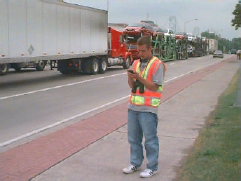
Figure 2. The Head of a Queue Can Be Far Away from the Border Crossing
2.2 Assumptions and Issues
The essential function that any candidate sensing technology must possess is the ability to collect data that allows measurement of truck travel time and, consequently, delay. A number of technologies exist – or soon will – that can use a variety of approaches to accomplish that same objective. However, there is a key challenge that confronts most of the technologies that could potentially be used in the methodology. That challenge is the need to have paired upstream and downstream collectors – in the same traffic flow direction – located in different countries. For the technologies that require onsite infrastructure to accomplish that, sensing technologies will need to be in Canada or Mexico in order to yield the paired data needed for matching. There is only one technology type that would not require such infrastructure: mobile phone locating, discussed in section 2.6.3.
Two important features that a successful sensing technology used for this application must possess are the ability to (1) identify a specific truck with a high degree of accuracy (i.e., 75% or greater), and (2) record an individual truck with a high degree of geolocation accuracy. That accuracy is assured with the technologies that have sensing technologies situated at specific locations, but it is currently more difficult to obtain with mobile phone locating.
It is not necessary that a sensing technology be able to capture every vehicle for the purposes of travel time data collection. It may, however, be an important requirement for inspection, tolling or other cooperative uses. That is not practical with the current manual data collection techniques, nor is there any compelling argument for an automated system to capture 100 percent of the vehicles especially if doing so results in higher costs. Total capture would be a useful feature but not essential.
This might mean that sensor hardware could be mounted to read vehicles in one of two or more lanes, assuming that there is no characteristic of the facility's geographic layout that results in any appreciable difference between the lanes. However, a collateral feature that is desirable is the ability of the sensing technology to yield the hourly crossing data, which has been difficult to get for both directions of travel at some border crossings.
If a sensing technology requires infrastructure, then ideally the sensing technologies will be mounted in similar – or comparable – configurations on both sides of a border crossing, for consistency. Obviously, any such arrangement will have to be worked out with Mexico or Canada. It is not often that the U.S. government purchases and arranges installation of hardware across the border, although that has reportedly been done.
Undoubtedly, there could be sensitivity to that issue unless it was clear that it is expressly for traffic measurement or if the technology is part of an operations improvement program for inspection and other purposes. There might be many benefits that accrue to Mexican or Canadian Customs, such as providing hourly counts, communicating trade information or toll charges. The USDOT data needs can be integrated into the information being communicated.
The license plate readers and vehicle matching technologies are sensing technologies that require infrastructure and have portable options. However, these portable options are quite expensive, costing tens of thousands of dollars per lane, and these platforms may have problems with vandalism if remotely located. It is difficult to align the portable license plate readers in a manner that equals the effectiveness of a hard-mounted reader.
2.3 Characteristics of the Border Crossings
Traffic flow measurements at the border crossings vary as a result of season, day, time of day, number of booths manned by Customs personnel, and additional security measures in effect (particularly after 9/11). When there is no congestion at primary or upstream of it, then the flow rate (trucks per hour) is equal to the existing demand (the amount of traffic volume that results at a facility under some set of travel conditions). This situation typically occurs when a crossing opens after being closed for a night or before any traffic starts to build up. It is used in the calculation for "travel time with no delay." If a queue exists at the border crossing, then the measured flow rate reflects the downstream bottleneck capacity; thus, actual measured flow rates would be less than the demand. Delay is measured in terms of flow rate and travel time in excess of the free-flow value.
2.4 Where Would Sensors Be Located?
For a technology that requires on-site infrastructure to replace data collectors, two sensing technologies will be needed for each direction of flow. The first sensor needs to be located in the exporting country upstream from the entry point into the Customs facility, generally just beyond the point to which queues ordinarily extend. Ideally, this would be in a location that all inbound trucks must pass (in other words, there are no other routes that could feed trucks into the queue downstream from this point).
The second sensor needs to be a short distance downstream from primary (in the importing country). Currently, downstream data collectors are stationed within approximately 180 feet from the booths at the primary checkpoint. The sensing technologies could perhaps be located where trucks leaving from the bank of (up to ten) primary booths could be funneled into fewer lanes, for technical considerations or reasons of economy.
Figure 3. Primary on the Mexican Side of the Zaragoza Bridge (El Paso-Juarez)
Figure 4. Primary on the U.S. Side of the Zaragoza Bridge (El Paso-Juarez)
Any radio frequency (RF) communications that are short-range or line-of sight would not work well at some locations, particularly the ones at which there are long bridges or a lot of steel mass (see figures 5 and 6).
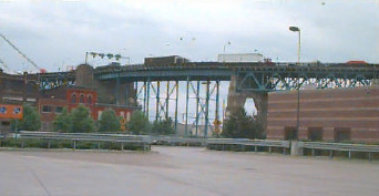
Figure 5. Some of the Border Crossings Have Large, Imposing Bridges
(Shown: the Ambassador Bridge, Detroit-Windsor)
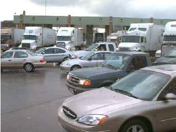
Figure 6. Discharge from Primary Can Be Congested
(Shown: Canadian side of Ambassador Bridge, Detroit-Windsor)
2.5 Overview of Vehicle Sensing Technologies
Table 1 lists vehicle sensing technology types and examines a number of characteristics that would factor into their individual suitability for the intended purpose of travel time calculation. The top-level characteristics of each are then discussed.
2.6 Candidate Sensing Technologies
To be a candidate for the short list of this study's trade-off study, a sensing technology must be able to:
- make positive identification of both inbound and outbound trucks at a matched pair of two points (upstream and downstream) that correspond to where data collectors are currently stationed for manual readings;
- time-stamp each vehicle that is positively identified at its detected location so as to enable travel time calculations, and;
- operate in all weather conditions found at a border crossing.
| Technology | Travel Time S/W[1] |
Low Volume Count | Not Privacy Invasive | Inclement Weather | Low Infra Cost | Positive ID |
|---|---|---|---|---|---|---|
| Ultrasonic | Yes | Yes | ||||
| Microwave Doppler | Yes | Yes | Yes | Yes | ||
| Microwave True Presence | Yes | Yes | Yes | Yes | ||
| Passive Infrared | Yes | |||||
| Active Infrared | Yes | |||||
| Visible VIP | Yes | |||||
| Infrared VIP | ||||||
| Acoustic Array | Yes | |||||
| SPVD Magnetometer | Yes | Yes | Yes | Yes | ||
| AVI Laser | Yes | Yes | ||||
| AVI RF Active Tags | Yes | Yes | ||||
| AVI RF Passive Tags | Yes | Yes | Yes | |||
| AVI RF Smart Tags | Yes | Yes | ||||
| AVI Smart Cards with RF Transponders | Yes | Yes | Yes | |||
| AVI IR Tags | Yes | Yes | Yes | |||
| AVI Smart Cards with IR Transponders | Yes | Yes | ||||
| Enhanced Common Inductive Loop | Yes | Yes | Yes | Yes | Yes[2] | |
| Signature Inductive Sensors (Enhanced Loop-Based Traffic Surveillance) | Yes | Yes | Yes | Yes | Yes | |
| Mobile Phone Locating | Yes | Yes | Yes | |||
| License Plate Reader | Yes | Yes | Yes | |||
| Vehicle Matching System | Yes | Yes | Yes | Yes |
1. Refers to travel time software currently in use.
2. Enhancement involves circuit card.
The sensing technology types in Table 1 that meet these essential criteria are examined in greater detail below. A "Yes" entry in Table 1 indicates a positive trait. A candidate sensing technology would ideally also be:
- inexpensive to purchase, install, and maintain;
- not easily vandalized;
- not seen as invasive of privacy by its users;
- capable of use without installation outside the U.S. border;
- able to count all vehicles that pass (as a collateral benefit to the overall border crossing truck travel time program); and
- communicate information (or connect to a computer that will) for other purposes (toll, Customs, etc).
None of the technologies that are examined below has all of the desired attributes. Furthermore, the only technologies in this list that are currently known to already have software for calculating travel times are the Automatic Vehicle Identification technologies (used for electronic toll collection) and the Vehicle Matching System (which is being used in Europe). However, development of software to work with any of these sensing technology types should be possible without great expense.
Automatic Vehicle Identification (AVI) refers to the components and processes of a toll collection system in which the equipment is able to determine ownership of the vehicle in order to charge a toll to the proper customer. AVI technology is broken down into three main categories: Laser, Radio Frequency (RF), and Infrared (IR).
2.6.1 Automatic Vehicle Identification (AVI) Laser
AVI Laser systems read a bar code attached to a vehicle, which is read by a laser scanner as a vehicle passes through a toll lane. This technology is susceptible to weather and dirt. Also, the barcode must be reasonably close to its reader, which reduces the distance over which this system can work.
2.6.2 AVI Radio Frequency (RF)
AVI RF systems utilize a transponder tag that is read by an RF reader/antenna. Some RF tags are used for vehicle-to-roadside communications, which can be used to inform the driver of traffic conditions. RF technologies include RF tags, RF smart tags, and smart cards with RFR transponders.
An RF tag is a device located in or on the vehicle that is used in conjunction with an in-lane RF antenna to communicate identifying information about the vehicle and customer to the toll system. The information stored in the tag is fixed (read only) and cannot be changed. The RF tag does not have any processing capability. This type of tag is referred to as a Type I tag. Some tags have an updatable (read/write) area on which an antenna/reader may encode information such as point of entry, date/time of entry, etc.
A RF tag operates in a half duplex mode, which means that it cannot send and receive data at the same time. The signal that it uses can be generated in one of two ways: actively (in which the RF tag contains a transmitter and generates its own RF signal) and passively (in which the RF tag modifies and reflects the signal it received from the antenna/reader. A passive RF tag does not contain a transmitter).
An RF smart tag is an RF device located in the vehicle that is used in conjunction with an in-lane RF antenna/reader to communicate identifying information about the vehicle, customer, and account balance to the toll system. Some portions of the tag information are fixed (such as vehicle and customer data) while others are updatable (such as account information). The smart tag contains a microprocessor which is updated each time the smart tag is used. RF smart tags operate in full duplex mode, meaning that they are able to send and receive data at the same time. They actively generate the signal used to communicate with the antenna/receiver via a transmitter.
The smart card with RF transponder is an integrated circuit device that contains a microprocessor and memory and stores account balance information. For toll collection, smart card use requires the smart card itself and a separate RF transponder (tag). The RF transponder is a device located in the vehicle that interfaces to the smart card and allows the smart card to communicate with the in-lane antenna/reader. In addition, the transponder contains information about the vehicle that it transmits to the antenna/reader along with the smart card information. The tags used with smart cards employ either full or half duplex communications with active or passive transmissions.
The toll operation at the World Trade Bridge near Laredo, Texas utilizes smart cards with RF transponders to collect tolls for around 95 per cent of outbound trucks (i.e., trucks leaving the U.S. for Mexico). There is an associated weigh-in-motion sensor that helps the toll agency charge by axle and weight. The weigh-in-motion sensor cable is located approximately 150 feet from the entrance to the truck tollbooths and extends across all eight lanes. This is the only smart card/transponder arrangement on the Mexican border, and it might present a great opportunity for a pilot test.
With this type of system, each toll lane is equipped with an RF antenna that is usually mounted in the center of the lane above the roadway. The reader sends out a signal via the antenna to the tag that lets the tag know that it should begin communication. The tag returns a unique ID number that is used to identify the vehicle (customer) to the electronic toll collection (ETC) system. In the case of read/write tags, smart tags, or smart cards with an RF transponder, the tag may transmit additional information such as account balance or point of entry and the reader may send back updated information to be encoded on the tag/smart card. The maximum read/write range of RF tags is generally up to about 100 feet. In use, they are usually within 20 to 30 feet of the antenna during communication.
Advantages of AVI RF sensor technologies include proven technology and relatively low cost. Disadvantages include infrastructure costs and the need for cross-border operational agreements.
previous | next