|
|
|
final report
Traffic Congestion and Reliability: Linking Solutions to Problems
2.0 Background to the Congestion Problem
2.1 THE SOURCES OF CONGESTION
Congestion results from the interaction of many different factors — or sources of congestion. Congestion has several root causes that can be broken down into two main categories:
Too much traffic for the available physical capacity to handle – Just like a pipe carrying water supply or the electrical grid, there are only so many vehicles that can be moved on a roadway for a given time. Transportation engineers refer to this as the physical capacity of the highway system. Physical capacity is determined by such things as: how many lanes are available to carry traffic, the curvature of the highway, side clearance, and interchange and intersection design (for example, length and position of on-ramps and exclusive turning lanes at intersections). Physical bottlenecks are locations where the physical capacity is restricted, with flows from upstream sections (with higher capacities) being funneled into them. This is roughly the same as a storm pipe that can carry only so much water — during floods the excess water just backs up behind it, much the same as traffic at bottleneck locations. However, the situation is even worse for traffic. Once traffic flow breaks down to stop-and-go conditions, capacity is actually reduced — fewer cars can get through the bottleneck because of the extra turbulence. Bottlenecks can be very specific chokepoints in the system, such as a poorly functioning freeway-to-freeway interchange, or an entire highway corridor where a system of bottlenecks exists, such as a closely spaced series of interchanges with local streets.10 Physical capacity can be reduced by the addition of "intentional" bottlenecks, such as traffic signals and toll booths. Opportunities to improve the operation of "intentional" bottlenecks can have the effect of boosting physical capacity.
Traffic-influencing events – In addition to the physical capacity, external events can have a major effect on traffic flow. These include traffic incidents such as crashes and vehicle breakdowns; work zones; bad weather; special events; and poorly timed traffic signals. When these events occur, their main impact is to "steal" physical capacity from the roadway. Events may also cause changes in traffic demand by causing travelers to rethink their trips (e.g., snow and other types of severe weather).
Physical bottlenecks have been the focus of transportation improvements — and of travelers' concerns — for many years. On much of the urban highway system, there are specific points that are notorious for causing congestion on a daily basis. These locations — which can be a single interchange (usually freeway-to-freeway), a series of closely spaced interchanges, or lane-drops — are focal points for congestion in corridors; major bottlenecks tend to dominate congestion in corridors where they exist. Many acquire nicknames from local motorists such as:
- "Spaghetti Bowl" in Las Vegas;
- "Hillside Strangler" in Chicago; and
- "Mixmaster" in Dallas.
How bad congestion becomes at a bottleneck is related to its physical design. Some bottlenecks were originally constructed many years ago using designs that are now considered to be antiquated. Others have been built to extremely high design specifications and are simply overwhelmed by traffic. A recent examination of national bottlenecks identified the worst physical bottlenecks in the country and examined the positive effects that improving them could have on travel times, safety, emissions, and fuel consumption. Table 2.1 provides a ranking of these bottlenecks.
| Rank | City | Location | Annual Hours of Delay (Hours in Thousands) |
|---|---|---|---|
| 1 | Los Angeles | U.S. 101 (Ventura Freeway) at I-405 Interchange | 27,144 |
| 2 | Houston | I-610 at I-10 Interchange (West) | 25,181 |
| 3 | Chicago | I-90/94 at I-290 Interchange ("Circle Interchange") | 25,068 |
| 4 | Phoenix | I-10 at SR 51/SR 202 Interchange ("Mini-Stack") | 22,805 |
| 5 | Los Angeles | I-405 (San Diego Freeway) at I-10 Interchange | 22,792 |
| 6 | Atlanta | I-75 south of the I-85 Interchange | 21,045 |
| 7 | Washington (DC-Maryland-Virginia) | I-495 at I-270 Interchange | 19,429 |
| 8 | Los Angeles | I-10 (Santa Monica Freeway) at I-5 Interchange | 18,606 |
| 9 | Los Angeles | I-405 (San Diego Freeway) at I-605 Interchange | 18,606 |
| 10 | Atlanta | I-285 at I-85 Interchange ("Spaghetti Junction") | 17,072 |
| 11 | Chicago | I-94 (Dan Ryan Expressway) at I-90 Skyway Split (Southside) | 16,713 |
| 12 | Phoenix | I-17 (Black Canyon Freeway) at I-10 Interchange (the "Stack") to Cactus Road | 16,310 |
| 13 | Los Angeles | I-5 (Santa Ana Freeway) at SR 22/SR 57 Interchange ("Orange Crush") | 16,304 |
| 14 | Providence | I-95 at I-195 Interchange | 15,340 |
| 15 | Washington (DC-Maryland-Virginia) | I-495 at I-95 Interchange | 15,035 |
| 16 | Tampa | I-275 at I-4 Interchange ("Malfunction Junction") | 14,371 |
| 17 | Atlanta | I-285 at I-75 Interchange | 14,333 |
| 18 | Seattle | I-5 at I-90 Interchange | 14,306 |
| 19 | Chicago | I-290 (Eisenhower Expressway) Between Exits 17b and 23a | 14,009 |
| 20 | Houston | I-45 (Gulf Freeway) at U.S. 59 Interchange | 13,944 |
| 21 | San Jose | U.S. 101 at I-880 Interchange | 12,249 |
| 22 | Las Vegas | U.S. 95 west of the I-15 Interchange ("Spaghetti Bowl") | 11,152 |
| 23 | San Diego | I-805 at I-15 Interchange | 10,992 |
| 24 | Cincinnati | I-75, from Ohio River Bridge to I-71 Interchange | 10,088 |
Source: Unclogging America's Arteries: Effective Relief for Highway Bottlenecks, American Highway Users Alliance, February 2004. Delay is the extra time it would take to travel through the bottlenecks compared to completely uncongested conditions. The report did not consider many severe bottlenecks from the New York City area. As most travelers know, congestion in and around the boroughs of New York can be significant. However, a very large amount of delay in the New York area is related to bridge and tunnel crossings into Manhattan, most of which are toll facilities. Also, while the New York metropolitan area is laced with Interstates, parkways, and expressways, they seldom reach the proportions seen in other major areas, except where multiple highways converge on bridge of tunnel crossings. (A typical lane configuration for a New York area freeway is six lanes, three in each direction. But there are many of these.) Toll facilities were excluded from the study because toll facilities are fundamentally different from other physical bottlenecks (such as freeway-to-freeway interchanges) that are prevalent around the country. Delay comparisons between toll facilities and other types of bottlenecks might not be consistent since different modeling techniques would be used. If objective field measurements of delay could be made at all locations around the country, several river crossings into Manhattan would no doubt be included in a list of the nation's worst bottlenecks.
Most of the worst bottlenecks identified in Table 2.1 are specific chokepoints: freeway-to-freeway interchanges where both freeways carry extremely high traffic volumes. However, several of them were identified as "bottleneck systems." In such areas, a single dominant bottleneck does not exist. Rather, traffic flow is influenced by several smaller bottlenecks.
The study noted that many of the bottlenecks are either under reconstruction or will be shortly. It also noted that the improvement "packages" undertaken by transportation agencies commonly combine reconstruction with other strategies such as operational improvements, high-occupancy vehicle lanes, transit service, and toll lanes.
However, just focusing on physical bottlenecks only tells a fraction of the congestion story. The transportation profession has come to recognize that the level of congestion on a roadway is determined by the interaction of physical capacity with events that are taking place at a given time. For example, the effect of a traffic incident depends on how much physical capacity is present. Consider a traffic crash that blocks a single lane on a freeway. That incident has a much greater impact on traffic flow if only two normal lanes of travel are present than if three lanes are present. Therefore, strategies that improve the physical capacity of bottlenecks also lessen the impacts of roadway events such as traffic incidents, weather, and work zones.
Only recently has the transportation profession started to think of congestion in these terms. Yet it is critical to do so because strategies must be tailored to address each of the sources of congestion, and they can vary significantly from one highway to another. Nationally, an estimate of how much each of these sources contribute to total congestion is as follows and depicted graphically in Figure 2.1:11 These estimates are a composite of many past and ongoing research studies and are rough approximations.
Figure 2.1 The Sources of Congestion
National Summary
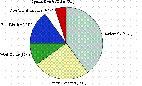
It is important to note that these global estimates of congestion sources do not necessarily hold for specific highway corridors. For example, some highways may have high crash rates, leading to a greater proportion of congestion due to traffic incidents. Others may be dominated by a physical bottleneck, such as a narrow bridge, leading to a higher proportion of bottleneck-related congestion. Differences in congestion sources between rural and urban are particularly striking. In rural areas, just about any delay that occurs will be event-related rather than caused by bottlenecks (insufficient capacity). In fact, in rural areas, preliminary estimates suggest that traffic incidents and work zones alone cause 80 to 90 percent of what delay that does occur. Of course, the total amount of delay in rural areas (about 400 million vehicle-hours of delay annually) is but a fraction of what occurs in urban areas (about 5.1 billion vehicle-hours of delay).12 These distinctions are extremely important because they indicate what specific strategies should be implemented at any given location.
2.2 THE GROWING IMPORTANCE OF TRAVEL TIME RELIABILITY
A Definition of Travel Time Reliability. The traveling public experiences large swings in congestion level, and their expectation or fear of unreliable traffic conditions affects both their view of roadway performance, and how and when they choose to travel. For example, if a road is known to have highly variable traffic conditions, a traveler using that road to catch an airplane routinely leaves lots of "extra" time to get to the airport. In other words, the "reliability" of this traveler's trip is directly related to the variability in the performance of the route she or he takes.
Reliability and variability in transportation are being discussed for a variety of reasons. The two terms are closely related, but are slightly different in their focus, how they are measured, and how they are communicated:
- Reliability is commonly used in reference to the level of consistency in transportation service; and
- Variability might be thought of as the amount of inconsistency in operating conditions.
Measures can be developed to relate the reliability/variability concept to "average measures" of mobility (i.e., measures that capture average conditions such as average delay, average speed, etc.) and to identify differences in performance by time of day, assessing the methods to measure reliability for long and short trips, different trip purposes, trip locations, etc.
With this discussion in mind, from a practical standpoint, travel time reliability can be defined in terms of how travel times vary over time (e.g., hour-to-hour, day-to-day). This concept of variability can be extended to any other travel time-based metrics such as average speeds and delay. For the purpose of this report, the terms travel time variability and reliability are used interchangeably.
What Causes Travel Times to Be Unreliable? The sources previously identified (e.g., traffic incidents, weather, and work zones) that contribute to total congestion also conspire to produce unreliable travel times, since events and demand volumes vary day to day. To illustrate how travel times vary, we observed travel times on a 4.05-mile stretch of I 75 in central Atlanta, from the I 20 junction to the I 85 split (Figure 2.2). To develop this figure, we calculated travel times of trips made at 15-minute intervals for the three-hour period from 4:00 to 7:00 p.m. (Data were taken from the NaviGAtor traffic surveillance system for 2002). This corridor is extremely heavily traveled: one location on this stretch carries more than 320,000 vehicles per day. The variability in travel times is caused by the interaction of the physical capacity, traffic demand, and all the events that occurred on this roadway section in 2002. That is, the interaction of all the sources of congestion produce unreliable travel times, as shown in the distribution of existing travel times.
Figure 2.2 Actual and Improved Peak-Period Travel Times on I-75 Southbound
Central Atlanta, 2002
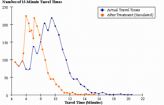
Source: The data plotted above for "Actual Travel Times" came from the NaviGAtor system in Atlanta, Georgia. The highway segment covered by these data is 4.05 miles long. Average travel times for vehicles moving along this segment were computed at 15-minute intervals for the three-hour period from 4:00 to 7:00 p.m. on weekdays for 2002. (This time slice is usually called the "afternoon peak period.") A total of 12 15-minute intervals are therefore present each weekday. If trips were able to be made at 55 mph, they would take 4.4 minutes to complete.
However, the average travel time for the 4:00 to 7:00 p.m. period is about nine minutes, indicating that (on average) peak-period trips are made at 27 mph on this segment. Many trips take much longer — a few took as long as 20 minutes (an average travel speed of about 12 mph). Others were made in shorter amounts of time. This large variability in observed travel times is due to traffic-influencing events occurring on different days, added on top of an already congested system. (The I 20 interchange at the south end of this stretch is a known bottleneck.) Traffic incidents may happen on some days but not on others. Bad weather and temporary work zones may compound the effect of traffic incidents or may happen by themselves.
The "After Treatment" travel times show the effect of reducing all travel times above seven minutes by 25 percent (hypothetically). This was done to simulate the effect of reducing the impacts of traffic-influencing events on travel. The "tighter" (less spread-out) distribution for the "After Treatment" case indicates that reliability (variability) has been improved. Also, since the majority of trips now have lower travel times, total delay also is reduced. This is indicated by the "After Treatment" curve's shift to the left. More specifically, the average travel time is now about seven minutes in the "After Treatment" case, reduced from nine minutes.
What Are the Benefits of Making Travel Times More Reliable? If it is possible to reduce the impact of these events on travel, a double benefit is realized: not only are conditions made more "reliable" (that is, less variable), but overall delay is reduced as well. This is because extreme events, especially in combination, lead to high congestion. As a proof of principle, we examined what effect this would have on the Atlanta travel times. We reduced all of the abnormally high travel times (those greater than seven minutes for the 4.05-mile corridor) by an across-the-board 25 percent. As shown in Figure 2.2, the effect is to reduce delay and improve reliability. Making improvements in both the average congestion level and reliability is significant for a number of reasons:
- Reducing total congestion saves time and fuel, and leads to decreased vehicle emissions.
- Reducing congestion at international border crossings leads to lower transportation costs and benefits the national economy as a whole. Further, reducing congestion on U.S. highways for freight moving between Canada and Mexico fosters international trade. Therefore, congestion on U.S. highways has a large influence on the efficiency of international trade.
- Improving reliability leads to more predictable and consistent travel in the corridor, something that all travelers seek: they do not have to budget as much extra time in order to arrive on time at their destinations. This is particularly important for truckers and shippers. Many activities (e.g., manufacturing, sales) are now closely timed to the arrival of shipments. Businesses depend on shipments to show up at precise times rather than holding onto inventories. Many types of personal travel — such as getting to business appointments and child care pickup on time — are also sensitive to unreliable travel times.
- Treating three major components of unreliable travel — traffic incidents, bad weather, and work zones — also leads to safer highways. By reducing the duration of these events, we are reducing how long travelers are exposed to less safe conditions.
What Value Does Providing Reliable Travel Times Have? Commuters as well as freight carriers and shippers are all concerned with travel time reliability. Variations in travel time can be highly frustrating and are valued highly by both groups. Previous research13 indicates that commuters value the variable component of their travel time between one and six times as much as average travel time. And the increase in just-in-time (JIT) manufacturing processes has made a reliable travel time almost more important than an uncongested trip. Significant variations in travel time will decrease the benefits that come from lower inventory space and the use of efficient transportation networks as "the new warehouse." Therefore, in both the passenger and freight realms, evidence suggests that travel time reliability is valued at a significant "premium" by users.
How Do We Measure Travel Time Reliability? Formal measures of how "unreliable" travel times are can be derived from describing the size and shape of the distributions, such as those shown for Atlanta in Figure 2.2. A complete description of the different measures can be found in Appendix C, but all of these relate directly to describing the distribution of travel times as they occur throughout the year. Returning to the Atlanta example, reliability statistics can be computed from these data, for both actual conditions and the hypothetical case of reducing abnormally high travel times (Table 2.2). These statistics verify what we observed in Figure 2.2 — that both delay and reliability are improved by treating "extreme" events. Operational strategies — which treat these extreme events — therefore have the effect of not only improving reliability but reducing total congestion as well.
| Southbound, 4:00 to 7:00 p.m. | ||
|---|---|---|
| Travel Time Measure | Observed Travel Times | Abnormally High Travel Times Reduced by 25 Percent |
| Average Travel Time (minutes) | 9.0 | 7.1 |
| 95th Percentilea (minutes) | 13.1 | 9.8 |
| Buffer Time Indexa | 46% | 39% |
a Reliability measures used by FHWA for performance monitoring. See Appendix C for definitions and discussion. The 95th percentile travel time is referred to as the "Planning Time Index" elsewhere in this report. The Buffer Time Index is the 95th percentile travel time normalized to the average travel time (see Appendix C). For both the 95th percentile travel time and the Buffer Time Index, high values indicate unreliable travel times.
Does Congestion Level Influence Travel Time Reliability? In other words, if travelers on average can expect high congestion, are their travel times also more variable? In general, the answer is "Yes." Figure 2.3 shows the Buffer Time Index plotted against the Travel Time Index for highway corridors in four cities. The plot reveals that as the average congestion level (Travel Time Index) increases, travel times become less reliable (as indicated by an increasing Buffer Time Index).14 Why does this occur? As congestion builds (i.e., the Travel Time Index increases above 1.0), the highway becomes more "vulnerable" to disruptions caused by events such as bad weather, work zones, and traffic incidents. That is, once traffic has broken down to stop-and-go conditions, throwing an additional event on top causes even greater problems. In other words, "congested highways also are unreliable highways."
Figure 2.3 Relationship Between Congestion Level and Reliability
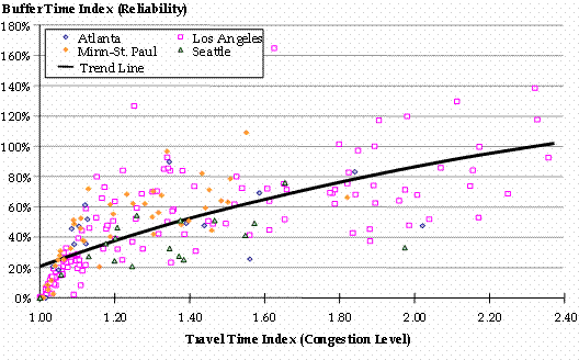
Source: Analysis of data from FHWA's Mobility Monitoring Program (see Appendix A for a description of this data source). Each point on the graph came from individual freeway corridors in Atlanta, Minneapolis, Los Angeles, and Seattle.
The Travel Time Index is a measure of the total amount of congestion. It is the ratio of the peak-period travel time to the travel time under ideal conditions. A Travel Time Index value of 1.3 indicates that peak-period travel takes 30 percent longer than under ideal conditions. Another way to think of this measure is as a "multiplier." That is, the value of the Travel Time Index is the amount you would multiply the "ideal" travel time by to get the actual travel time you experienced. Thus, "Travel Time Multiplier" would be an alternate name for this term.
The Buffer Time Index is a measure of reliability, or more appropriately, unreliability. As it increases, travel times become more unreliable. Although conditions vary from highway-to-highway and city-to-city, a general relationship between congestion level and reliability is present in these data — as congestion increases, so does unreliable travel.
Many more performance measures can used to monitor congestion besides these. Appendix B has a discussion of performance measures.
10 In rural areas, physical bottlenecks take a different form. Highway grades can be a significant problem for large trucks in rural areas. Also, surges in travel to resorts during the "peak" season and travel around holidays can overwhelm physical capacity for some time. However, since traffic is lower in these cases or only lasts for a short periods of time, the total amount of delay on a yearly basis is far less than in major urban areas, where just about every weekday of the year is congested.
11 http://www.ops.fhwa.dot.gov/aboutus/opstory.htm; estimates of the effects of variable traffic demand are not available.
12 Preliminary estimates from the Temporary Loss of Capacity project underway at Oak Ridge National Laboratory. Estimates of rural delay include traffic incidents, weather, work zones, and traffic signals. Rural delay also includes that due to highway grades and high demand in recreational areas, but these have not been addressed.
13 Cohen, Harry, and Southworth, Frank, On the Measurement and Valuation of Travel Time Variability Due to Incidents on Freeways, Journal of Transportation Statistics, Volume 2, Number 2, December 1999, http://www.bts.gov/publications/journal_of_transportation_and_statistics/volume_02_number_02/.
14 A brief explanation of these terms appears in Figure 2.3. Appendix C has a more thorough discussion.
Previous |Table of Contents | Next
| Last modified: February 1, 2017 | ||