Mitigating Work Zone Safety and Mobility Challenges through Intelligent Transportation Systems
Case Studies
CHAPTER 4 - MANAGING TRAFFIC DURING CONSTRUCTION BY SUPPLEMENTING EXISTING PERMANENT ITS: I-15 CORE, UT
Many agencies across the country have some roadway mileage where permanent intelligent transportation system (ITS) technology has been deployed for transportation management purposes. When road maintenance or rehabilitation/reconstruction occurs within or near these permanent deployments, agency staff and personnel may use these systems to minimize the impacts of the road work activity. This chapter provides an example of how the Utah Department of Transportation (UDOT) combined temporary work zone-specific ITS efforts with their existing transportation management system on I-15 through Orem-Provo to help manage traffic during construction.
Overview of the Project
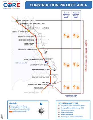
I-15 serves as the main north-south artery in Utah. Within the Orem/Provo region, UDOT conducted a 24-mile widening and reconstruction project, as shown in Figure 12. Called the I-15 Corridor Expansion (I-15 CORE) project, this $1.725 billion project involved the addition of two lanes in each direction of travel and the widening and reconstruction of 10 interchanges and 63 bridges. This design-build (DB) project had the potential to significantly disrupt public mobility and safety, as well as freight movement, so UDOT desired an aggressive construction schedule. As a result, the project had full closures at night, interchange closures, and peak period lane reductions on I-15. The notice-to-proceed (NTP) was given in January 2010, with project completion set at 35 months. It was one of the most aggressive schedules for a project of this size ever let in Utah (and possibly the U.S.).
UDOT has extensive permanent ITS capabilities. The UDOT traffic operations center (TOC) is a computer-controlled system designed to monitor and manage traffic flow on freeways and key surface streets throughout the State. System components include closed-circuit television (CCTV) cameras, electronic changeable message signs (CMS), the 511 Travel Information Line, coordinated traffic signals, ramp meters, traffic speed and volume sensors, pavement sensors, and weather sensors. The center is connected to smaller traffic control centers in Salt Lake City and Salt Lake County. The existing freeway traffic management system that was already in place along the corridor (initially implemented for the 2002 Winter Olympics in Salt Lake City) was used and enhanced to facilitate the management of travelers through the corridor during the I-15 CORE project.
Applicability of the Engineering Design Process to the Case Studies
Defining the Problem
|
Key Problem
|
As part of the project development process, UDOT established three key project goals:
- Minimize inconvenience to the public,
- Uphold the public trust, and
- Maintain regional mobility.
The project posed significant challenges to meeting these goals. The biggest challenge was that only one alternative detour route (an arterial) was available adjacent to the freeway. Thus, the region would have limited ability to absorb any diverted traffic from I-15 during periods of temporary capacity reductions. In addition, lane shifts, the restriction of shoulders, and other temporary geometric constraints could increase the effect of incidents and special events occurring in the region. Additionally, there was the potential for congestion to develop in locations along I-15 where existing ITS infrastructure was limited or non-existent, thereby limiting the ability of TOC personnel to respond quickly and properly to any issues that arose. Therefore, efforts focused on ways to maximize the traffic-carrying capacity of the arterial street system and on providing travelers with accurate travel information to assist them in making trip decisions.
A regional travel demand model was used to develop an understanding of how travel patterns might change during construction. A work zone delay analysis program developed by UDOT staff (similar to QuickZone) was then used to further estimate possible project impacts. Additional analyses were done by the various DB teams during their maintenance-of-traffic (MOT) designs that were required as part of their bids.
Specifying Key Requirements of the Solution
|
Solution Requirements
|
As part of the DB proposal request, UDOT established basic traffic mobility requirements regarding allowable times and dates for freeway lane closures and let the contractor develop the rest of the MOT plan. The three main solution requirements involved the coordination of traffic signal systems within Orem and Provo, making solutions compatible with existing TOC components, and aiding travelers with making trip decisions.
Given the availability of the existing UDOT TOC, emphasis was put on determining how to enhance the current capabilities of the system to maximize its potential benefit for managing traffic during construction. The TOC was heavily involved in the development of a request for proposals (RFP), and TOC staff were integrated in the project management team to facilitate identification and implementation of traffic management strategies as needed during construction. Other entities on the project management team included consultant staff, ITS deployment consultants, and local signal contractors.
Identifying and Evaluating Alternatives
Because UDOT has significant permanent ITS capabilities in place, they focused on alternatives that would make use of these capabilities. UDOT wanted to integrate efforts to manage work zone impacts with its existing TOC, so all alternatives identified and considered were assessed with an eye towards compatibility with that system and with the potential for keeping those improvements in place once the project was completed. A windshield survey was performed in the corridor early in the planning process to determine what “holes” in traffic management infrastructure existed (especially camera coverage). As part of the alternatives identification, vehicle detectors, CCTV cameras, traffic signal control systems, and CMS were inventoried to identify locations where additional temporary or permanent infrastructure was needed.
It became apparent during the project planning process that it would be extremely beneficial to upgrade the arterial signal systems in Provo and Orem to become compatible with the UDOT centralized signal system. This would allow for the use of an existing ITS capability during the project, while improving the TOC capabilities long-term after the completion of the project. Cooperative agreements were established between UDOT and the cities to help define how the signals would be operated and coordinated, and the systems upgraded to be compatible with the UDOT system. UDOT also decided to make strategic investments in permanent ITS infrastructure, using its normal capital and operating budgets and procurement procedures, to expand its capabilities within the corridor.
Selecting, Designing, and Implementing the Best Solution
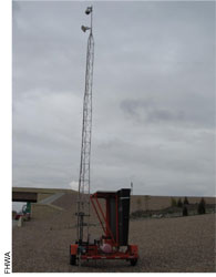
While some identified needs were for temporary devices during construction, the long-term needs of the TOC were considered as part of the implementation process. Portable traffic sensor stations were procured as part of the project in a few instances until permanent sensors could be installed (see Figure 13). In other locations, a need was identified for a few temporary ramp metering systems to maintain management capabilities until the widening effort on I-15 was completed and such metering would not be required. In addition, the winning DB team examined traffic management needs in the corridor, and proposed an arterial travel time monitoring and information system for the alternate route, State Street, as a value-added component to its proposal to aid travelers in making trip decisions.
Improvements were subsequently made to several signalized intersections, adding left turn phases and right turn overlaps to improve overall signal operations and flexibility to deal with changing traffic patterns that might develop. A “mini” TOC was created and housed in the project offices to allow staff to monitor MOT setup and view issues in the corridor in real time. A number of incident detour plans were developed for the corridor, and courtesy patrols in the corridor were enhanced. Two years prior to the I-15 reconstruction, ramp meters were installed knowing they would be reconstructed as part of the I-15 project. Plans were made to maintain all devices during construction to allow project staff to manage delays. Close coordination between the UDOT TOC and public involvement staff further helped to minimize delays throughout the life of the project.
Some of the additional ITS devices identified as being needed for the project were paid for through normal TOC funding mechanisms. Other additions were then incorporated into the project bidding requirements. Some of the technology (such as the northbound travel time arterial system on State Street) was proposed by the winning team as a value-added concept that was accepted by UDOT, but handled directly by the contractor. In general, UDOT has a well-structured process for obtaining ITS equipment and services. No specific issues or problems with procurement were identified during the case study. It was noted that the procurement process for ITS in general has evolved as needed over the past 20 years.
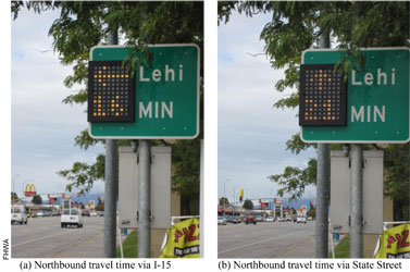
As noted above, the winning DB team proposed a value-added real-time arterial travel time system for the alternate route, State Street, to improve route choice by providing motorists comparative travel times along the arterial and via the adjacent interstate (see Figure 14). A series of six sensor “pucks” per location was installed in one lane of the arterial every 0.5 to 1 mile. Electronic vehicle “signatures” were tracked from location to location along the arterial from which travel times could be calculated. The winning team also proposed additional courtesy patrol vehicles in the corridor (UDOT was operating 3 vehicles prior to construction) to further reduce the response time and magnitude of incidents on traffic delays.
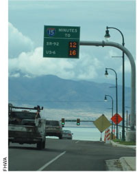
The freeway ITS and arterial signal system operated on a fiber optic backbone, which was maintained throughout the construction process. Some radios were purchased and installed on the project and connected to the fiber optic backbone in a few instances to maintain functionality of some of the devices. As with most ITS deployments, UDOT established a significant testing protocol of devices and subsystems as they were brought online, both for any construction-related implementations (such as the supplemental temporary ramp metering systems), as well as any of the final build devices that were installed (such as the travel time signs as shown in Figure 15).
Although UDOT retained responsibility for operating the ITS deployment during construction, the DB team was assigned maintenance responsibility for keeping devices operating, communications flowing, etc. Some training was needed to bring the DB team up to speed on some of the systems (signal timing, ramp metering). Failure to keep the system functioning warranted withholding of payment.
The TOC was operated weekdays between 6 am and 10 pm, and from 10 am to 8 pm on Saturdays. The center was also staffed for special events or construction activities outside of these windows as needed. TOC staff managed information disseminated on the various signs in the corridor, and monitored the various ramp meters to ensure they continued to function as intended. The TOC goal was to “stay ahead of the congestion curve” as long as possible. Staff also monitored conditions on the arterial street system and had large number of timing plan alternatives that could be implemented quickly as conditions warranted.
Evaluation and Lessons Learned
Usage Statistics and Performance Evaluations
Overall, UDOT was happy with the operation of the system and believed that it significantly reduced the number and magnitude of delays and congestion that would have been incurred during construction if the system had not been in place and operational.
UDOT performed traveler surveys in the corridor every quarter during the project. The surveys consistently demonstrated a high level of customer satisfaction and support of the traffic management actions undertaken by UDOT. UDOT also prepared annual reports about the project, documenting the following items:
- Key traffic management and control actions implemented,
- Public awareness and involvement activities undertaken,
- Number of full I-15 closures performed at night,
- Peak period lane reductions on I-15 enacted,
- Interchange closures,
- Actions implemented during major special events, and
- Preview of work and closures anticipated for the next year.
UDOT focuses on travel times, delay, and speed as primary measures of effectiveness for ITS deployment. Both duration and magnitude of delays are considered. These measures were continuously monitored during the I-15 CORE project. Table 4 summarizes some of the impacts of construction activities documented in the annual reports.
| Measure | 2010 | 2011 |
|---|---|---|
| Full I-15 Closures: Number of nights | 30 | 32 |
| Full I-15 Closures: Maximum delays | 50 minutes | 45 minutes |
| Full I-15 Closures: Typical delays | 15 to 30 minutes | 15 minutes |
| Full I-15 Closures: Maximum queue | 3 miles | 2.5 miles |
| Full I-15 Closures: Typical queues | 0.5 to 2 miles | 0.25 to 2 miles |
| Full I-15 Closures: Maximum duration of congestion | 180 minutes | 180 minutes |
| Full I-15 Closures: Typical duration of congestion | 60 to 90 minutes | 15 to 120 minutes |
| Peak period lane reductions: Number of days | 76 northbound, 99 southbound | 76 northbound, 104 southbound |
| Peak period lane reductions: Typical queues | 2 miles | 2 miles |
UDOT also used the ITS devices to help mitigate the impacts of construction on certain special events that occurred during the year. These events included Brigham Young University (BYU) football and basketball games, the July 4th fireworks celebration, large concerts, and snowstorms. Special timing plans on the arterials were developed to encourage more use of those streets, and information about alternate routes and parking access points were disseminated via CMS and the media.
The system was instrumental in encouraging diversion away from I-15 during certain phases of the project, and in accommodating that traffic on the arterial street system. Diversion rates around 20 percent were routinely accomplished, and on nights when full closures of I-15 were implemented, up to 50 percent diversion prior to the point of closure was noted. UDOT expects the approach taken on I-15 regarding the use of ITS to be the model for all future major projects of this type.
The effectiveness of the arterial street travel time system was somewhat limited, but was still considered a worthwhile addition to the project. Initially, it was envisioned that diversion from I-15 would occur primarily in the northbound direction, with State Street being used by trips originating south and east of the interstate when traffic conditions were degraded on northbound I-15. The vehicle detection technology used to track vehicles was found to track only about 1 percent of the vehicles using the northbound arterial, and led to sizeable errors (30 to 40 percent) in travel time estimates being generated. UDOT noted that they adjusted the times on those signs and on the I-15 travel time signs under congested conditions to encourage or discourage diversion from the freeway.
The availability of mobility-related data from the various ITS components also benefited the project contractor. UDOT staff noted that there were instances where lane and ramp closure restrictions were relaxed at the contractor's request, once staff had the opportunity to review the traffic data and determine that relaxing the restrictions would not adversely affect travel conditions. In this way, construction time windows were able to be effectively maximized.
Lessons Learned
Include maintenance of ITS devices in the list of conditions warranting liquidated damages – Although UDOT retained responsibility for operating the ITS deployment during construction, the DB team was responsible for keeping the various ITS devices in the corridor operational. Initially, the contractor was not always timely with making whatever repairs and adjustments were needed to keep the devices working, to the point that UDOT decided to withhold payment on the project until repairs were made. Adding ITS device maintenance as an item with liquidated damages for non-performance could help ensure that the contractor understands the importance the agency is placing on keeping the system operational at all times.
Leverage the ability of contractors to innovate on how to best accommodate traffic during construction – UDOT was pleasantly surprised with several ideas that the winning contractor presented in their MOT approach to the project. Using contracting approaches that allow (and reward) contractors for innovative approaches to managing traffic provides benefits to the contractor, the department, and ultimately, to the traveling public.
Verify that proposed innovations and technologies will operate as advertised – The arterial street travel time system that the contractor proposed was envisioned to be a good value addition to the project. However, the technology suffered from a number of issues, ranging from a deployment approach that limited the ability of the system to track vehicles from sensor location to sensor location along the corridor to problems with the sensor devices themselves. It would be preferable to more fully assess the viability of the proposed installation before it is deployed.
Consider using temporary ramp meters if peak-period demands will exceed the reduced work zone capacity during construction – Ramp metering along many of the ramps on I-15 allowed UDOT to effectively manage peak traffic demand and travel conditions. As construction progressed on the project and modified travel patterns, there were opportunities to put temporary meters in place to maintain management capabilities at some of the ramps that were not metered. This allowed UDOT to more effectively manage traffic within the project. Once construction was completed and I-15 capacity increased to the point where ramp metering was not needed, it could be removed.
< Previous | Next >